Terpeast
-
Posts
6,618 -
Joined
-
Last visited
Content Type
Profiles
Blogs
Forums
American Weather
Media Demo
Store
Gallery
Everything posted by Terpeast
-
Yeah that makes sense
-
Interesting. Not quite sure what to make of this. Could it be coincidental with other factors being the drivers?
-
Awesome, thanks! Looks like it’s at -0.32 now, with it being closer to -0.2 a couple days ago
-
Definitely made great progress on the PDO. Looks slightly negative to me, or even neutral (within +/- 0.5 is how I define neutral), just a tad warm across the entire basin. Where do we get the daily PDO chart? It was -0.33 last time I saw it posted here. As far as the IOD goes, I’m not sure it has much value in winter season forecasting. I couldn’t find a strong correlation with EC temps, precip, or snowfall. If anything, we want it to be positive. For the MJO, just about all phases are going to be open for business, including 4-6. The difference this year is that 8-1-2 should also be open for business.
-
True, its MEI was 0.9 so it must have snuck its way into my list. I’ll exclude that next time
-
From 0.6? That's quite the big jump. I'm thinking 0.8 or so. But it will be telling. There's a big difference between <1.2 MEI ninos and >1.2 MEI ninos since 1980. MEI <1.2 MEI >1.2
-
In the winter, yes. But it's still early-mid fall, so the wavelengths are different this time of year. I think you and bluewave were alluding to the correlation flip in October a couple of weeks ago, and I think this is a good example.
-
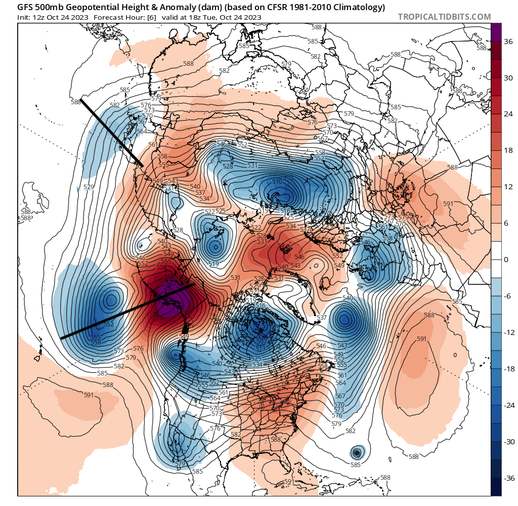
Powerful rex block in place with troughing off Japan having an impact on SSTs in the N Pac, and the PDO. North Pac SST anomaly changes over the last 15 days: This is reinforcing the recent PDO rise from extreme negative to neutral territory, which is a sign that the atmosphere may decouple from the PDO going into winter. Of course, as I said would happen before, going from extreme -PDO to a decoupled PDO would be rough for us for a while with strong -PNA episodes. Like the one happening now, giving record 80 degree warmth over the eastern seaboard. This is a necessary evil to rip the bandaid off.
.png.66ddf715fdd3647784a6bb868402587b.png)
-
34.9 with a light frost
-
I noticed that, too. I think you and I are looking at the same area, and bluewave may be looking at a different or smaller area
-
Yeah it’s not a guarantee as we’ve had a couple of ratters in the nino cohort (72-73, 91-92 and probably another within the 50s) The definition of a modoki is even more nebulous to me, so I just stick with east based, basin wide, or west leaning based on where the forcing is. I’ll have a write up on this in Nov when I do my outlook, but current thinking is that an “decent but not crazy” winter is the most probable outcome, with a 09-10 redux being the second likely outcome. Another ratter i think has the least chance of happening, but still a non zero chance
- 921 replies
-
- 12
-

-
Gotcha. Just noticed "EMI", not "MEI". Dyslexic moment
-
Is that the new MEI value?
-
I think with the PDO rising to neutral, but with the lack of upper OHC, I think this nino holds at around 1.6-1.7 at least for the next few weeks with weakening trades.
-
The difference here is that I’m saying the far-south blocking has indeed happened before in specific cases (note that I’m not blending them), and the MA still got hit. Where I agree with you is that this kind of blocking will be more frequent going forward. I guess our difference lies in what really happens in our backyards when we get those blocking episodes. In an el nino, I say bring it on.
-
@bluewave Pertinent to our discussion, I like what this met was saying about HL blocking (starting at 10 min): While he didn’t specifically mention the AMO, he showed the interplay of blocking between low pressure systems in other parts of the globe, and how that delivers cold air outbreaks. We have to look at the entire hemisphere when looking at blocking.
-
Low of 42
-
I prefer looking at the entire northern hemisphere and expanding the gpm scale. You only have the scale at +/- 50 gpm, which leaves out a lot of detail and we don’t know where the center of blocking really is. Then zooming into only north america cuts out a lot of other details, like the interplay between blocking and aleutian lows/ridges. Besides 1983 and 1996 had blocking pretty far south, enough to cover NE with above normal height anomalies. Finally, the 2020s were all ninas with moderate to strong -MEI. This is the first year in the 20s that the MEI has finally flipped into el nino territory. We don’t have a sample size to work with in the 20s.
-
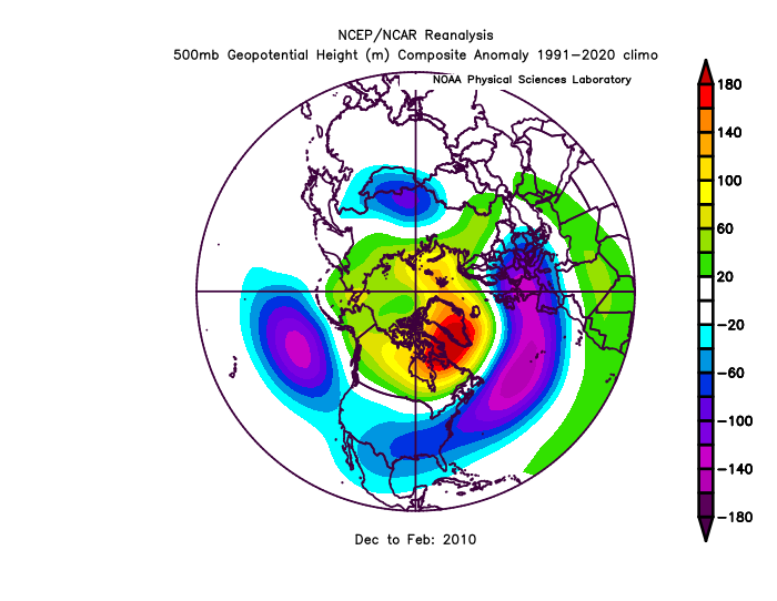
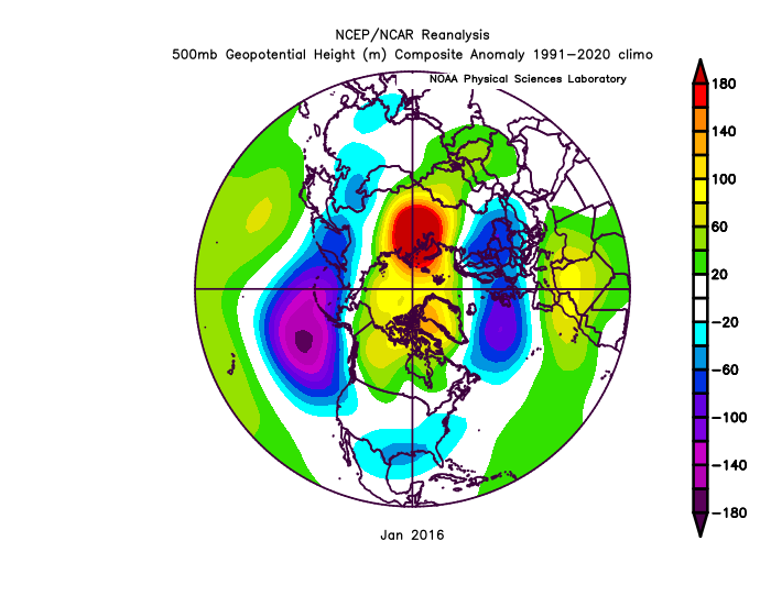
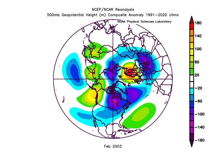
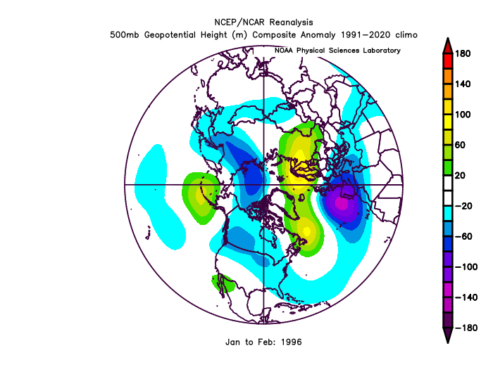
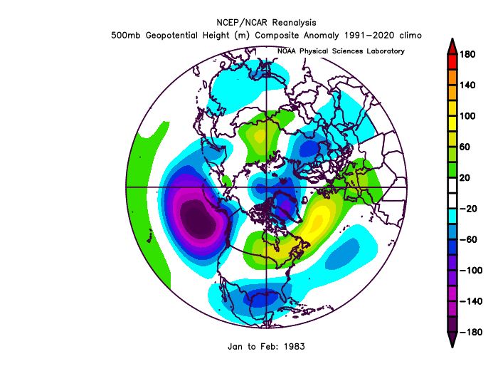
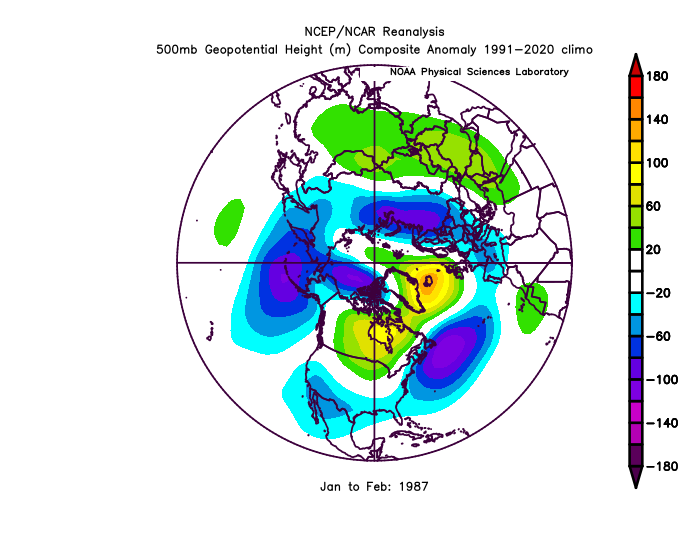
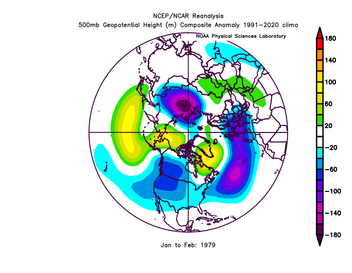
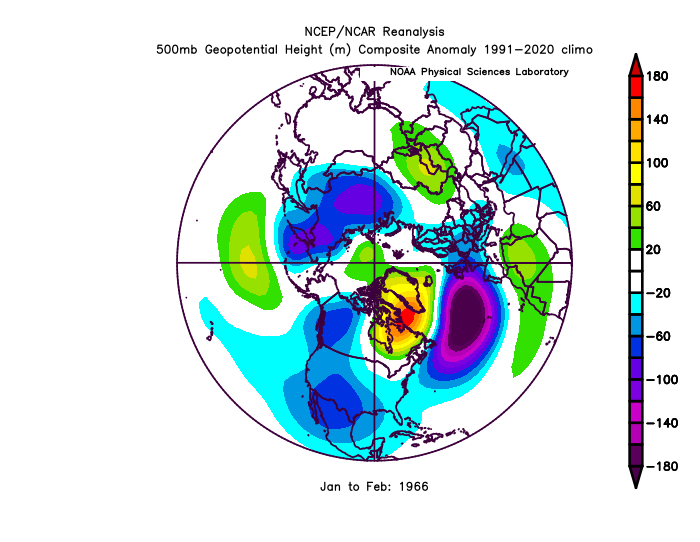
So I went down this rabbit hole... (lol) I compared the AMO-H5 regression with the months containing the biggest MA snowstorms going back to 1966. Here is the AMO-H5 regression, which supports the theory that a warm Atlantic promotes HL blocking further south or SW than Greenland: I tried to explore the amplitude of the AMO and its relationship with HL blocking, but I couldn't find anything compelling. I think the ENSO variance (and other tele's) washes it out when I combine too many years. Next, I compared the above chart to the months containing (or leading up to) the biggest MA snowstorms, starting with the holy grail of 2010: Look how pretty far south that blocking was. Very similar to the AMO-H5 regression, except the trough under the block was much deeper (stronger jet). Also, the presence of an aleutian low was key. Next up, 2016: That block was pretty far north up Baffin Bay, paired with a strong aleutian low and a strong STJ. I think it was the pacific that really drove this one without much need for blocking. Or something is getting washed out with mixed signals throughout the full month. Now, Feb 2003: That's a weird one. No blocking, except all the way out to scandinavia. There's even a SE ridge OTS. Canada was very cold, so it was one big massive overrunning event as opposed to a miller A bomb. Next up, 1996: A lot of mixed signals resulting in a washed out look, but you can see a -NAO with two areas of blocking. One primary over Scandinavia, and one secondary off Newfoundland. That's pretty far south for a block, and yet, the MA went on a massive heater... despite a weak aleutian ridge signal. Strange but fun winter... it could easily have gone the other way. Next, 1987: One area of east-based blocking up over Iceland with a strong -NAO and 50/50 trough. Presence of Aleutian troughing. Now, 1983: That block was so far south that we even have troughing over Greenland, with +H5 anomalies over New England. And yet we got a historic KU. Very strong aleutian low a big player here. PD1 1979: Block was far south/southwest of its typical orientation, and PDI was a cold storm that ranks #3 at DCA. No other storm has been able to top this one at this specific airport site. We also see western troughing and a weak aleutian ridge here. Finally, 1966: This block was pretty far southwest, accompanied by a noteworthy low to the west of Europe. All in all, a further south/southwest based block should actually be reassuring for us folks in the MA and SE as it likely helps, not hurts, our prospects of getting a big snowstorm as long as the other tele's support it, namely ENSO and PDO. But if you live in Maine or Boston, it's probably bad news (and I'm sure you've suspected this already). NYC is kinda in between.
-
Yeah you do make a good case on this. Last year was a very strong nina in terms of MEI, though. PDO was deeply negative, so we had a -PNA firmly in place, which helped link the SE ridge with the south-based block. This year is different (most likely) so maybe this will create some new scenarios where south based blocks will actually help the MA & SE with snowstorms… IF we get enough cold air via +PNA to begin with.
-
Makes sense. The next thing I want to try is to break out tiers of positive AMO and see how the strength affects blocking, and then maybe project this year out because the AMO is in unchartered territory. Could it mean more suppressed tracks during a nino as the block forces storms to go under it? Could it force storms to cut as they eject eastward, or is that more of a nina thing even with strong blocking? Could it also mean that storms will be even more juiced and even slower moving as they “sit n spin”? Means someone is getting over 40” somewhere Who knows, maybe all of the above… in one season.
-
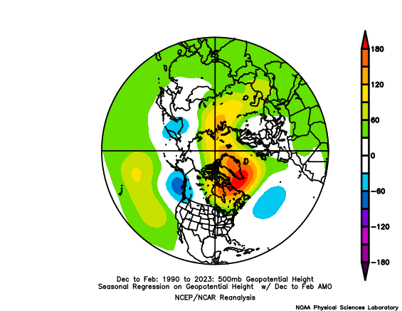
I found something potentially interesting. According to this dataset, the AMO is at its highest ever. https://www1.ncdc.noaa.gov/pub/data/cmb/ersst/v5/index/ersst.v5.amo.dat Latest AMO is well over +1 in the last several months. Latest Sept value is +1.41 If this has any actual bearing on winter, it may favor south/SW shifts to N Atlantic blocking based on a H5 regression vs AMO using 1990-2023 as the base period. Look at the gpm values in the axis... the signal is strong. Very strong. Any thoughts? Is this important to include in our winter outlooks? Or am I just going down another rabbit hole?

-
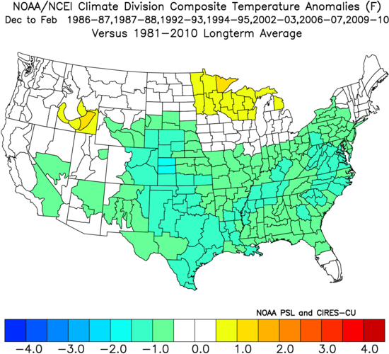
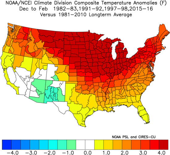
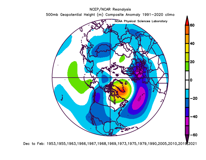
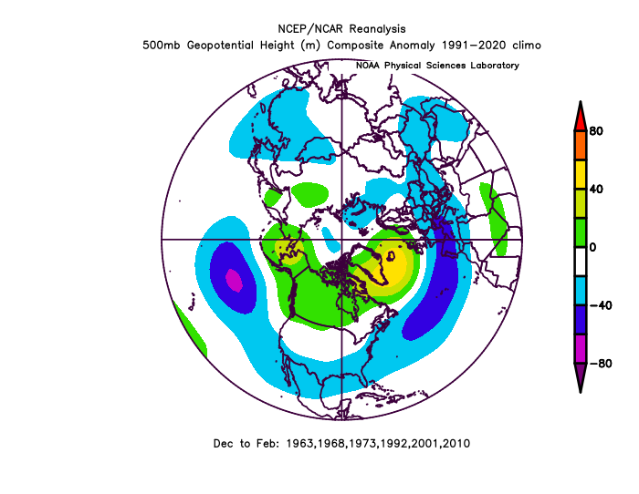
Since we're heading into neutral PDO territory, but we still don't expect it to go positive. PDO may bounce in the cold neutral range from here on out. So here's what a cold-neutral PDO winter looks like at 500mb. I didn't filter by ENSO or any other tele. All winters between a DJF average of between 0 and -0.5 PDO since 1950. - weak signal of an aleutian ridge and some western US troughing, which makes sense - stronger blocking signal over on the atlantic side, but may be confounded by other contributing factors like qbo, etc Take it fwiw. I've also been playing around with analog winters that followed a strong rise from deeply negative PDO. I used -1.5 as the threshold anytime between April and July preceding the following winter, and selected winters that were neutral PDO on average. It is rare for a deeply negative PDO to rise to neutral so quickly within 6-9 months into the following winter. This has only happened 5 times in the last 70 years. This year may be the 6th. Here's a 500mb composite of winters following a strong and rapid PDO rise out of deeply negative territory: This time you see an aleutian low N of Hawaii, which had to be the driver of the strong PDO rise, and it seems to have stuck throughout those winters. Also N atlantic blocking seems to be a recurring theme. Note I changed the contour intervals to get rid of the exaggerated cold bias of older analogs.
-
Yeah, the oct run of the euro must have been initialized when the pdo was close to -3. Last I checked, we’re within 0.5 of neutral, so I’m curious what the nov run will have to say. Maybe it’ll look more like the sept run, or maybe it’ll stick with the SW trough idea, or come up with something entirely different.
-
Octorcher or Roctober 2023 Discussion Thread
Terpeast replied to Damage In Tolland's topic in New England
It was never going to be long lasting. The N pac rex block causing the -pna and the subsequent flip to cold is only going to last 5 days, so both warm and cold are going to be transitory.