Terpeast
-
Posts
6,687 -
Joined
-
Last visited
Content Type
Profiles
Blogs
Forums
American Weather
Media Demo
Store
Gallery
Everything posted by Terpeast
-
I think we’re going to see crazy swings like this this winter, given all the mixed signals we’re seeing now
-
Its a pretty +pdo look
- 1,295 replies
-
- 1
-

-
- wishcasting
- almost winter
- (and 1 more)
-
43, rain Nice to see precip/radar overperforming vs models
-
Yeah.. I don’t really follow 850mb wind anoms in the tropics because all the models show something completely different even for the same runs. What gets posted here is often different from what I see on the model sites. So I gave up on following this
-
Light rain, 46
-
The pacific is much better now than it was a couple months ago. It’s not ideally where we want it to be yet, obviously. But it’s slowly been getting better. If it backtracks in Dec-Jan though, this winter is going to be an uphill battle For now, we’re still in the game.
- 1,295 replies
-
- 4
-
-
- wishcasting
- almost winter
- (and 1 more)
-
Yeah, we don't want to gamble with that over just perturbing the PV. There's little support for a SSW event though, only 4 ensemble members show it
-
Only made it to 76 before the clouds moved in from the NW, down to 71 now
-
Pretty consistent with my outlook
-
Yeah, I’m a bit concerned about the marine heat wave off Japan, but that’s not a PDO thing, something else is going on
-
And that’s not the worst thing. We (well, I) don’t want a super nino. It’s a hit vs miss gamble for one HECS, and if we whiff it’s yet another ratter. Besides the last 3 times we had a super nino, we had triple dip La Ninas right after. So I’m not rooting for a super, personally. And I agree with you that we don’t get there.
-
I just think it mostly means we’ve peaked. we’ll see about those wwbs east of the dateline starting nov 15, but hard to say if that will move the needle
-
Only made it to 61 today after hitting 77 yesterday
-
I don’t know about the NOAA data for real-time monitoring because it’s monthly and I would think there is some kind of lag. I mean if the big pdo rise is not showing in that dataset, it may either mean its a month behind or something isn’t right with their data
-
Time sensitive - WCS daily PDO holding at -0.88. Looking at the ensembles, I expect it to hold around there or touch -1 again, then rise after that.
-
Absolutely. It could swing the other way next month, or take its sweet time into getting above 0.5 till January. But then again, I expected it to come in at 0.75 this month and I was wrong. So...
-
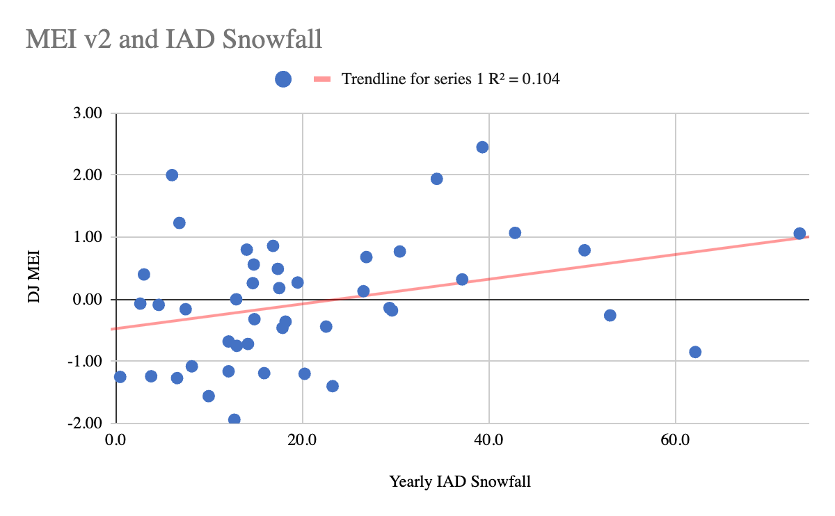
For KIAD, there is a weak positive correlation between snowfall and MEI. It's noisy and mostly a crapshoot, but we can clearly see a few things: - If the MEI is less than -1.0 (stronger Nina), it gets very difficult for us to reach climo or above. Most often we end up with less than climo. - If the MEI is greater than +1.0 (stronger Ninos), we likely get a warm winter overall and MAYBE with a HECS that pads snowfall totals. No HECS? Ratter. - If the MEI is between -1.0 and +1.0, it really can go either way. Notice that if we are between +0.5 and +1.2 (which I prefer using as the cut off), our chances for a colder and snowier winter go up. MEI +1.2 or higher: MEI between +0.5 and +1.2 So this recent drop in MEI probably precludes us from getting over +1.2, which may be a good thing in avoiding a mild winter for the CONUS, but I think we will need to get a more favorable nino profile in the pacific to get a colder winter than the last 8 years.
- 1,295 replies
-
- 14
-
-

-
- wishcasting
- almost winter
- (and 1 more)
-
Great job, I think we're tracking along the same lines for our outlooks. I have mby at 60% chance of above snowfall climo, so you're about 10% more bullish than I am
-
And he’s willing to discredit his own work in hopes of getting one. I’m thinking maybe I should have used RONI instead.
-
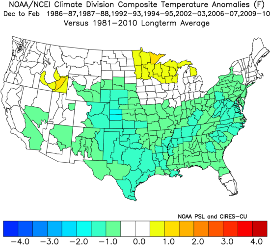
And it also came after a triple dip nina (kind of - 85-86 was cold neutral)
- 1,295 replies
-
- 5
-
-
- wishcasting
- almost winter
- (and 1 more)
-
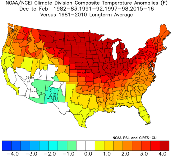
Too soon, same thing happened in 1986-87. It’ll probably go back up in the next month, but if it doesn’t, then I’ll probably consider updating my outlook.
- 1,295 replies
-
- 1
-
-
- wishcasting
- almost winter
- (and 1 more)
-
It's going to be a noisy day tomorrow. Get ready... (I've already said my piece earlier today)
-
Sorry @GaWx This is what I used, not the other link. It was a pain to copy the color coded table into my own excel, though.
-
https://psl.noaa.gov/enso/mei.ext/table.ext.html Just note they don't match up well with the new v2 index though
-
Well, he's got a point right there.