Terpeast
-
Posts
6,649 -
Joined
-
Last visited
Content Type
Profiles
Blogs
Forums
American Weather
Media Demo
Store
Gallery
Everything posted by Terpeast
-
Light snow finally
-
Nothing. Band split apart and went around me
-
MJO going into phase 3 by mid-late Feb. MJO 1 (where we currently are) in a weak nina (-GLAAM regime) is actually warm for the east, 2 less so, and 3 is cold. Usually assume a few days lag, so the "warm up" behind the frigid saturday makes sense.
-
I wouldn’t be surprised to see a similar storm track as the Jan 25 one. Not saying same results exactly, but more of a general idea where it tracks towards the TVA/OHV region with gulf moisture feed, and then coastal transfer. Obviously a further south track across TVA then across S VA would yield better results for our backyards.
-
And this general look is now within 10 days, lowering the chances of yet another rug. Can still lose it, but the idea of a wave undercutting the decaying block has been on the ensembles for at least a few days now.
-
Thats been the theme for 6+ months now
-
If I wanted to troll the forum, I would post this: Oh wait... (its an op run 10 days away, so don't take it too seriously)
-
I wondered the same thing when I saw my temp at 42
-
Looks like the follow up is for C/S VA instead of NC... does this trend continue? We'll find out after the commercial
-
I'm no expert on the stratosphere, but it looks like it's about to split into two, which promotes more HL blocking?
-
Bad news, aigfs is an op model so little confidence in its blizzard scenario. The GOOD news is ensembles (including euro and ai euro) do have some support for that scenario by undercutting a s/w under HL blocking. The ens means is smoothed out, but if you can “read between the lines” you can see a sharper trough or ULL swing across the mid-south towards us from feb 13-16.
-
As a glass half full kind of guy, I’m with you. The very fact that NC got their HECS should give us a lot of optimism about our future winters. We will get ours one of these winters, and many more to come. Instead and unfortunately, some choose to look at it as a zero-sum game where we get mad when folks south of us are getting more snow than we do. I also don’t think we’re done with winter yet, but if we really are, we have an El Nino to look forward to. It’ll probably be a milder winter than the last two, but at least we’ll have our chances with an active STJ.
-
Lock it up
-
32 now. But not much melting if any
-
Since I moved back to the area, we've gotten zilch in March... so the WDI is off the charts.
-
Sacrifices must be made
-
Strat warming is on the atlantic side, so that should knock the AO back down. Can already see hints of it doing that in the dashed mean line starting to turn downwards right at the end.
-
Both GEFS and EPS have a follow up wave on the 15th after a cutter, with a cold enough airmass for us. I'll be watching that one.
-
LOCK IT IN
-
Phil says nasofast...
-
Looks like a potential swfe overrunning event from midwest to NE, but could include us depending on how well we hang onto the cold. Usual disclaimer applies
-
Nothing new. Lived through some bad runs and plenty of close misses here. At least everything is still white here with 6 ft snow piles as if we had just gotten a flush hit.
-
It does show some undercutting energy that could give us a mixed event or moderate snow if we could hold onto enough cold. Early for details, but it’s not a total shutout
-
And btw, the pattern we just had really delivered. We just didn’t have all of the luck on our side. Could just as easily have had 2 blizzards in one week, so if I see Jan 2026 analog again, I’ll by honking loudly about it.
-
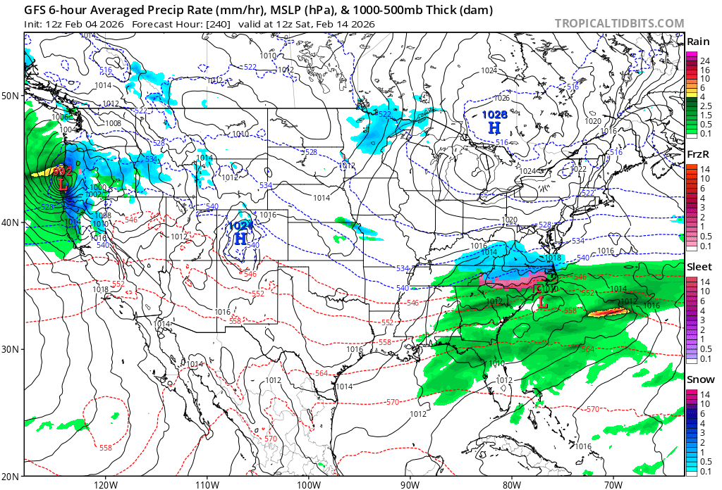
Looks like a big change/flip in the long range over the last 24 hours. One run does not make a trend, but 3 00z/12z runs in a row just did a resounding repudiation of the freezing february pattern. Interestingly, AI ensembles led the way on this. We may be able to thaw this glacier out by presidents day weekend, or if its not as warm as progged, weekend after. Unfortunately we may have lost big snow chances for the next 2 weeks, and by the time it gets cold again with the SSW effect and weak MJO 3, we’d be running out of time by that point. Not saying it won’t snow then, but more likely to be smaller to moderate events.