psuhoffman
-
Posts
27,417 -
Joined
-
Last visited
Content Type
Profiles
Blogs
Forums
American Weather
Media Demo
Store
Gallery
Everything posted by psuhoffman
-
Not going to do them much good. By the time they build up their base the torch will come and obliterate it. Its likely going to be a very rough year for them. By the time we get consistent cold (if we do) its likely too late for them to recover. They might have a good second half but losing the front 1/2 of winter is a killer for them. And in years where it’s crappy early often people turn to other things or go out west and it impacts them later too. Just realistically it’s going to be a bad year for them. It happens. They are used to it. The resorts that do a good job managing their Capitol will survive so long as we don’t get multiple years like that strung together.
-
This is an oversimplification but as the heat released from the convective waves expand away from the equator (poleward) it is deflected to the right of its path by the coriolis effect. So basically... vs the cold phase convection locations the exact effect of the mjo wave phases change seasonally as the wavelengths and resistance to the heat release changes. But in winter that is the basic effect.
-
I do a lot better than DC. And I’m not complaining. But I’m not far enough north that I’m not susceptible to snow droughts also. But when it’s good it can get really good. And when the pattern is marginal it can be pretty good here. But the total fail suck fest patters aren’t much better here either. I’m not the frozen tundra or anything.
-
Draw a line west of the mountains and that’s about how much...and you wouldby like it. You would sacrifice a few small storms from west to east clippers for big totals where CAD saves us from a flip. Our best storms that track south of us have enough easterly wind component that the downslope isn’t an issue. It’s when we’re stuck in a pattern with lows going to our west that it sucks but that pattern wouldn’t be that good anyways.
-
I work in Baltimore. So I’m well aware. I often see it go from snowcover to nothing once I get into the city. From experience I don’t expect there to ever be much at work.
-
The climo thing is old. I get frustrated when we go stretches without snow and I get more of it so I don’t blame anyone for the frustration. So simply saying it has sucked is fine. When I go off on someone like Mdecoy or whatever he is going by now, it’s not for being frustrated, it’s for making up BS climo proclamations. It’s ok to feel like it sucks. But it’s not ok to pretend this isn’t normal. Truth is our climo sucks. Every once in a while we get lucky with a year or most recent a string of them when snow comes easy. The other 75% of the time is long stretches of nothingness with an occasional fluke storm or two mixed in if we’re lucky. Our base state is suck. We’re just far enough north that in a rare good pattern where the jet gets suppressed near our longitude we can get into the goods. The rest of the time we’re frustratingly too far south. Close enough to feel screwed when the storms go just north of us.
-
I thought it was a bad run.
-
How much did Baltimore city get March 21 2018?
-
It doesn’t look good but there are ways out. Those years were mostly Nina’s. If the NAM state flips the last week of Jan the mean pattern may look more like the non Nina analogs I posted. The new weeklies are a better look in Feb. not great. But they won’t be right exactly. If they are wrong and the trough is a bit more suppressed with a bit more ridging over the top it becomes a good look. If it’s the other way...not so much. Flip the coin.
-
Off hour run. Toss it. ...it is ugly though. Undoes all the improvement as goes right back to a neverending shutout look. But like I’ve said the gefs is more prove to run to run shifts. Unless it has multiple runs or the eps heads that way I’m not sweating it.
-
Like it matters he just tossed out a 12” storm as “barely counting”. Lol
-
I counted jan 2019....the rest are out of season and I dont remember dec 2017 I think it was Dec 9 2017. I had 6” up here. The cities only had 2” or so but I know not far NW had 3-5”. I think IAD had 4. Maybe it missed lees burg.
-
We've had one snowstorm since 2016 blizzard....what are you going to smite? Dec 2017, March 2018, Nov 2018, Jan 2019 And here come the reasons they all don’t count lol.
-
I actually liked him and corresponded with him semi regularly through emails when I was a meteorology student at Penn State in the late 90's and early 2000's. He was always friendly and helpful with my questions and seemed like a really nice guy. He also seemed to really know his stuff. I still think he knows his stuff...I just think he has an agenda. The last time I messaged him we got into a spat about my local climo and his forecast. He was trying to use Washington's snow average to say my area verified his forecast. And then he refused to believe me that I averaged 40" here. And when I pointed out that DC didnt get what DC averages he got snippy. That was the last private conversation I ever tried to have with him. I will admit he has also said some dumb things about teachers that didn't sit well with me but mostly its just his act got old after a while, and he went off the deep end with everything.
-
Both the EPS and GEFS have been moving the extent of the pac ridge further north and that is a significant change also. The more it builds over the top the more it helps attack the TPV over the pole and helps press down on the flow over the CONUS. When we were seeing unanimous support for an incredibly anomalous flat central pac ridge north of Hawaii that was really bad. This look not nearly as much. Still not good yet...but not the utter dumpster fire it was.
-
This is closer to workable than where it was 2 days ago. get that Scandinavia ridge to poke into the NAO domain a little more and it sets off the chain reaction we need. It’s still got a ways to go but we’re seeing progress. I can see an easy way out from that look. The one the other day when the euro spilled a whole blue paint can all over the high latitudes was hard to even see an easy way out. Seeing it back away from a continuation of the raging +NAM state is the best sign.
-
Definitely. What I am most encouraged about is where that might go. The look day 10-15 is still not really great for snow...but that look matches patterns that rolled forward lead to snowier times. Not there quite yet but build that ridging over the top just a little more and suddenly the western energy starts to slide across under us and its game time again.
-
In fairness to JB (you all know I can't stand him but truth is truth) he admits he was wrong quite a bit. He will spin so that it's "not his fault" with stuff like "I had this or that right but..." but the bigger issue is he is stubborn as all get out and will wait way way way too long to adjust. He is so scared to "flip flop" that he holds onto an outdated idea way too long. There are no points for that... a forecast should always be based on the preponderance of best evidence available. We have to adjust when better evidence, and in weather more recent is almost always better than older guidance/data. As for seasonally.. he will spin a crap look into "not that bad" to try to keep the weenies paying for another month or two...then admit defeat once its well into Feb and apparent his cold/snowy winter idea is toast.
-
in fairness he admitted his excitement is mostly due to lack of anything else to be excited about
-
lol I have no change in my forecast until I actually see what falls and then I will adjust/spin accordingly. Until then keep paying your subscription.
-
I suppose a true "cutter" is a storm that bombs out into the lakes...but we have come to call any system that goes to our NW a cutter. And there most definitely can be a track to our NW in a progressive pattern if there is too much ridging along the east coast and no blocking.
-
As long as it totally caves on the long range pattern too I will forgive it this once. Seriously though...I know the running joke is "why does the model with no snow always win" but that isnt true when we are in a pattern conducive for snow. Granted it does't seem that way but that is because 80% of the time we aren't in a good pattern for snow. But that is our climo. But when we know the overall longwave pattern isn't conducive for a snowstorm...going with the model with the snowy outcome, even when it's the euro, is a bad idea. I know you know that...just pointing it out before we get the typical comments.
-
One saving grace about the PAC ridge pattern is it will promote enough cross polar flow that there should be ample cold in western and northern North America. That means things can flip FAST if we can get some mechanism to get that into the east.
-
@Bob Chill That look matches the "better" enso analogs I posted earlier today way more than the disgusting looks the guidance were tossing out 24-48 hours ago. It's a subtle difference...the main one being the higher heights pressing the pattern over the top from Scandinavia and the EPO ridge poking over the top more as well. Not only is that look better for our prospects the rest of January...but it is a MUCH better omen for our prospects in February. That look tends to roll over into a pretty good pattern more often than the one we were getting yesterday. Hopefully this trend continues and we may be able to open that escape hatch after all.
-
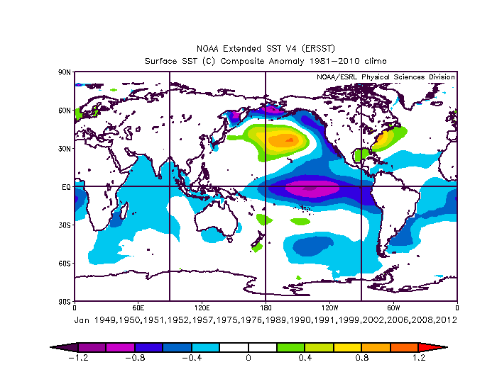
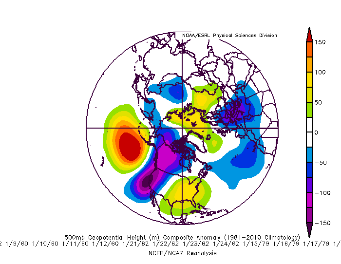
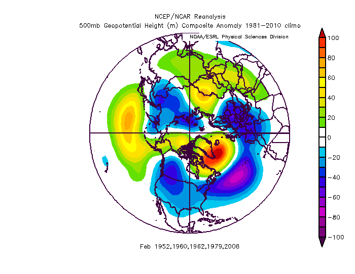
Showmethesnow and some others are all over the medium range threats. The upper low pass this weekend is interesting. My gut says the low wraps up a little too late for anything significant in our area. That is usually how these go, but that H5 pass is good enough to think a little surprise is possible. The day 6 thing depends on 2 things imo. If we can either get the energy crashing into the west to back off and not compress the flow which prevents the system digging under us in the east....OR if we can get a little more ridging near Hudson bay. There has been a trend towards some ridging there...a bit more and that can compensate and act as a bootleg block. We actually have had a lot of decent snow events from that bootleg look. But... looking ahead I wanted to post something hopeful for long range. I already posted the analogs to a January central pac ridge +NAM regime and its not good. BUT...I was thinking almost all of them are either Nina years or cold neutral following Nina years. There were no good enso comps within that set. The fact that all of them were nina years might indicate this year could have more a chance at variability than those did when the enso supported that ridge alingment more than the current sst does. Look at the SST anomalies for the years I posted before...NOTHING like this year. Almost the complete opposite actually. So I went looking for somewhat similar years where there was at least a 1-2 week pattern like what is coming during a similar enso. I will admit this took some liberties. I did restrict it to January patterns but I had to cherry pick weeks from different parts of the month to find comps. Admittedly there really are NO great comps other than nina years. And admittedly the NAM state isnt as awfull as it is right now in these 5 comp patterns I found...but overall its a close enough look to think this might have some merit. There were similar patterns for a portion of January in 1952, 1960, 1962, 1979, and 2006. 1952 was a borderline weak nino warm neutral enso. 1960 was a neutral following a nino, 1962 was neutral following a neutral. 1979 was a neutral following a weak nino, and 2006 was a very weak nina following a nino. Those are all much better enso matches. This is the composite of the January periods that looked somewhat similar to this year. This is the February patterns for those years For the purposes of scientific integrity I will admit that the methodology used to get these matches was more biased and subjective than the last set of analogs. But it is true that those others do not match our current SST or ENSO at all. These years are better matches in that regard. These years are also perfect PAC matches. They are not as good wrt to the AO/NAO though, especially for the whole month. But we don't know yet what the second half of January will be. We can assume the first half will feature a PAC ridge +NAM regime but the second half could flip enough to alter the monthly mean look some. But for these to be valid we need to see the NAM state start to flip soon. What differentiated these analogs from the others the most was that by mid January the NAM state was in transition to a negative AO/NAO combo that lasted the rest of those winters. There were absolutely no examples of a similar pac look that improved at all absent a better AO/NAO state. One other interesting thing to note, and someone asked about this yesterday. Most of the years that improved did so by retrograding the pac ridge NOT progressing it. My take away from this... if we start to see improvements up top by the middle of January the door is open to a much better outcome...and that is supported by enso analogs. But those years this pattern didn't lock in for more than 2 weeks or so. The years where this NAM/PAC combo locks in for more than 2/3 weeks or so...its permanent and lasts pretty much all winter. We are still a ways away from being at that point...and there have been some baby steps in the long range trends wrt the NAM state. So when factoring in the enso and sst there may be more hope than the previous analog look suggests.