

psuhoffman
-
Posts
27,419 -
Joined
-
Last visited
Content Type
Profiles
Blogs
Forums
American Weather
Media Demo
Store
Gallery
Everything posted by psuhoffman
-
This...we have been in a pac puke pattern from an AK vortex. That isn’t good for the pac NW either. It’s also not good for us. Right now we are in a temporary flux between patterns and that’s why we have a shot as a minor snowfall tomorrow. But the coming pattern is good for the west bad for us. But the pac coast needs an anomaly to get snow even in a good pattern.
-
I know you aren't saying its "good" just better...but my fear with that look is that even if we got a colder shot as the trough slides east...with that look in the PAC, along with the EPO/AO/NAO it would be extremely short lived and unlikely to include much snow. IMO that pattern rolled forward the CONUS is about to get blasted by pacific air again like before xmas. What is left of the western trough would roll through and then we would go zonal. A week after that pot I would suspect we would see a big blue ball up top and a ring or red around it across the mid latitudes. Very 2002 like...that is how that year evolved. We are seeing a singular point in time at day 15 which looks "better" but I don't think that look is heading anywhere positive for snow opportunities. Maybe "better" than the absolutely worst look imaginable we will be in for about a week before that...but if we were in anything close to a decent pattern now looking at that in the long ranges we would be pretty upset about that look. ETA: ironically even though the GFS looks like a hot mess on wheels at day 16, its evolving the pattern in a direction that at least has a fraction more hope/possibility beyond that time period.
-
I have flat out said it so people can hate on me if they want...but if we get to Jan 15 or so and we are still looking at what we are looking at now...then yea I agree with that. I showed how this currently pattern in January...more than 50% of the time can persist all winter. But the minority of years where this pattern in January did flip better in February the signs of that were showing up well before February. In all of those examples by the last week of January the pattern was in transition. If we get to the point where we can see to February and it still looks like utter crap with a central pac ridge and +AO we are entering territory where no previous example turned out good. We aren't there YET... still another 10 days or so to see real improvements before we are to that point, but the clock is ticking.
-
No I think there is a possibility someone in our forum gets a small event (depending on your standards, Ji and Mdecoy should probably ignore it though). But even if DC manages a nice 2" event Tuesday the idea of reaching climo for winter is still in some jeopardy given the pattern look we are seeing. But even most of our really bad years had some snow at some point. When I say things don't look good I usually mean wrt to climo not that we won't get any snow at all.
-
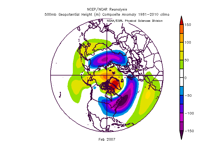
GEFS looks like crap long range BUT at the very very end its showing a way out. The NAM seems to be flipping and we are one good wave break (maybe from a cutter) from getting the atlantic ridging to build over the top and link up with the Pac ridge...and that is when that western trough will broaden and come east. You can see it starting to move east at the very end in response to the changes up top. Now taking the day 16 GEFS is silly...just saying it is on its way to a better place by February IF that look is right. Thats all. BTW, just to clarify what the purpose of my pattern posts was. I am NOT saying there is no hope. I didn't even make a real forecast...I made a seasonal one and if those pattern analogs are right it will bust. I don't really make day 20 forecasts...thats silly. I was just posting the analogs to what we are looking at and showing what the past indicates the likely outcomes are. And yea, historically most of them turned into pretty bad winters. But some did not. I am rooting for the "some that turned out ok". But the numbers are what the numbers are, not a forecast, just a "this is what happened in the past when we had a similar pattern in January". It is not what I am saying will happen or what I am rooting for. But given the reality of the past results I have tempered my own expectations so that I am not frustrated everyday when things don't suddenly look like a winter wonderland on guidance. If we get a 1960 or 2006 type pattern flip GREAT and I will be even more excited given my current low expectations. BTW we can probably include 2007 in that flip category. It didn't work out great for us but we did get some snow AND the pattern was great in Feb 2007 even if the results left a lot to be desired. As I pointed out in the climo thread...luck has as much to do with our results as pattern sometimes.
-
The discussion you replied to was comparing the gfs and gefs. The implication of what you said was clear.
-
They are exactly as useful as they were a year ago when they were still linked to the old gfs op. They didn’t degrade somehow they just haven’t progressed. The new gefs will no doubt be an upgrade. But I guarantee you the current gefs is vastly superior at very long leads to relying on a single operational run. Of ANY model
-
Day 10 op euro would actually set up a good pattern day 11-15. Builds enough of a ridge bridge to suppress the pattern get the boundary near us. A little more HL blocking and this is suddenly a really good look. We need to see the ensembles start to go this way though. So far just an op run at range
-
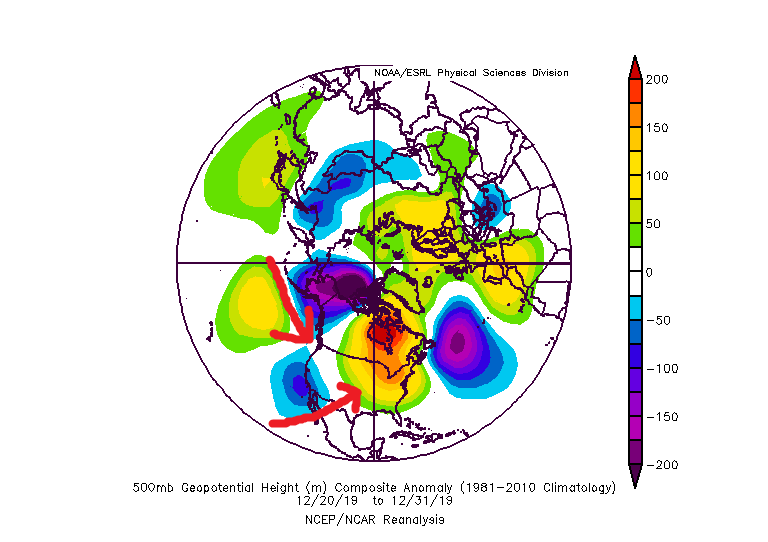
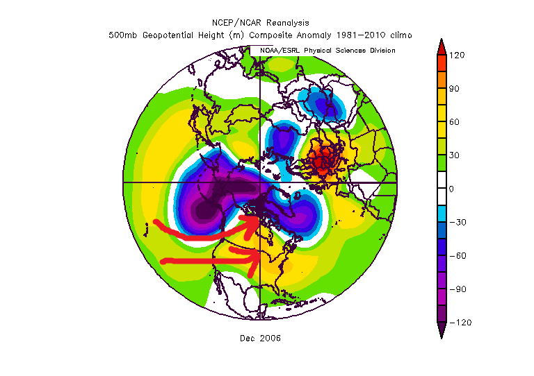
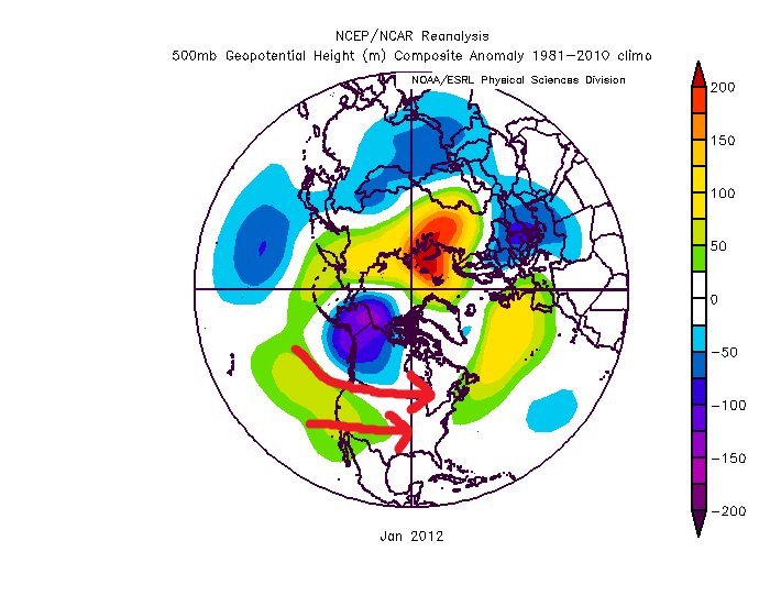
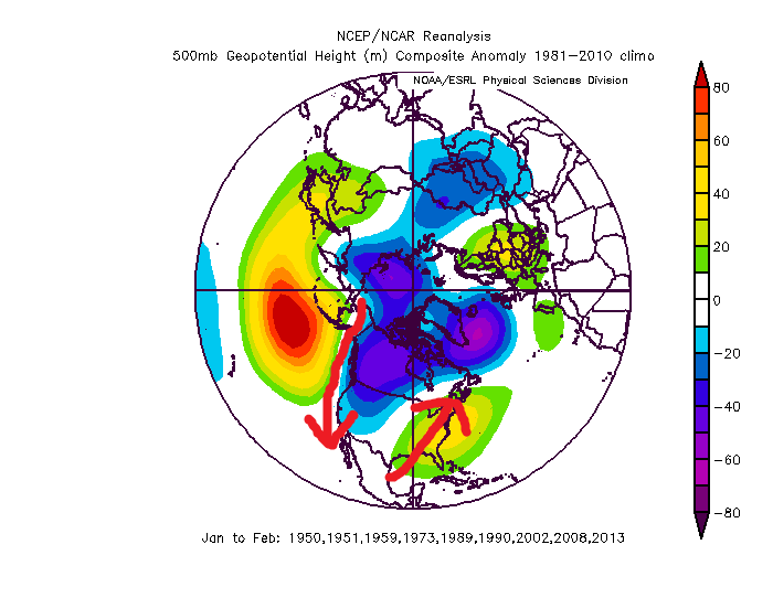
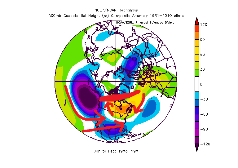
Sure but I am not going to spend as much time studying our fail patterns as I did our winning ones. I just don't hate myself that much. But I know off the top of my head what years and patterns really suck balls and put together a quick profile of some of the worst ones. First of all... while we can score a fluke snowfall in many patterns...the truth is there are way more looks that just don't work out often then there are ones that do. We are south of the mean northern stream jet in winter most of the time. It takes an anomalous pattern to get snowfall. The warm wet cold dry thing is real. Often in winter the only time the cold boundary gets south of us is after a wave passes and the flow behind it presses the boundary south. But without a favorable pattern the return flow ahead of the next wave is likely to press the boundary back to our north before it gets here. Basically the average storm track is to our north. But most patterns with some luck and some bootleg factor (like a Hudson ridge) working for us we can occasionally get snow. But most patterns without luck we can easily go with no snow as well. Bad Luck On top of that...sometimes we can just get unlucky in a perfect pattern. A storm gets suppressed, the next one is just slightly too warm, another develops off the coast...next thing you know we wasted a 2 week perfect pattern. The winter of 2007 would fall into that category. Look at this H5 pattern for Feb March was pretty good also for a good portion of it. THe first half was pretty crappy and I will use December 2006 as an example of a crap look later but even with a wasted Dec into Jan if you told me that would be our look for Feb and Mar I would take my chances. ANd while we did get some snow...we didn't cash in on the full potential and so the winter went down as a below avg snowfall year. There were 2 blockbuster coastals that year...one in Feb and one in Mar and both were just SLIGHTLY too warm at the mid levels and the big snowfall ended up a little NW of us. THere was one storm that had big potential but a PV lobe at the wrong time squashed it. And a couple others just failed to reach potential and ended up minor snowfalls. We mostly wasted a really good pattern. That has happened other times as well. On top of that, even more common, we waste a look that is OK, not great but definitely not awful and end up with a really bad result. YOu can look at the H5 for a year like 1981 and say...that looks ok. Not epic but you wouldn't think a horrible dud winter was coming, but it was. Truth is snow here is anomalous and luck wrt timing and discreet features that fall under the pattern level have a LOT to do with our results. Call it luck or chaos but pattern is only half the fight. So all that said I will focus on a couple patterns that just really really really suck and give us almost no chance for a significant snowfall, luck be damned. Some general observations First of all, any pattern that features a +NAM state without either a perfectly placed east based EPO ridge...or a really favorable PNA ridge is a fail pattern. We can score in a +NAM pattern but only with pacific help. If the AO/NAO are both awful (like right now) and the pacific inst in a very favorable state...that is a total fail pattern. That is because anything that pumps a SE ridge without resistance up top will not end well here. Additionally there is seasonal variance. The NAO is way more important later in the season. As the temperature profile tends to get colder across N. Amer later in the season and wavelengths start to shorten in Feb, and water temperatures cool along the coast, blocking on the atlantic side can influence and overcome the pacific pattern more. Early in the season we really need pacific help to have a good chance. But bad looks can be very temporary or transient so what patterns tend to give us that and lock in for an extended period of time. I assume that is what you mean because we can have a bad week even in the best winters...but what looks spell doom for a really long time and eat up a big chunk of our winter window. AK Vortex Pattern The first is an AK vortex pattern. This one is especially a killer early in the season. It can be overcome from Mid Jan onward but only with NAO blocking. Early it tends to be a problem even with blocking. Without blocking this look is a total fail pattern all winter long. You pointed out earlier that 2012 was a good example. December 2006 was also a perfect example. The last 10 days also featured this problem. I have the h5 below...the issue with this pattern is the flow under the AK vortex floods the continent with warm pac air. Without ideal blocking on the NAO side that mild air will flood across and not only will we be warm but there won't be any cold air anywhere near us. This pattern can take a LONG time to recover from. Even once the pattern improves we can waste a week just getting cold back onto our side of the hemisphere. Dec 2006 January 2012 Last week... Pac Ridge +NAM pattern The next one is the one we are about to go into according to all guidance. How long it lasts is yet unknown...but this is the absolute worst pattern we can possibly ever get into in winter, both because of how bad it can be...numerous examples of completely snowless months with this pattern...but also because of how stubborn it can be. Frankly this is the most common season destroyer of all the patterns. This one accounts for the majority of our total fail winters. This is the composite of many of our total fail years that fit this description, the Jan/Feb of 1950, 1951, 1959, 1973, 1989, 1990, 2002, 2008, 2013. All of these were single digit snowfall years at BWI except 1990 but all the snow fell that year BEFORE the pattern set in early January. look familiar? This one is real simple...that pac ridge digs the trough out west...which pumps the ridge in the east. Simple wave physics. Without extreme blocking to offer resistance that will push the thermal boundary well to our north. The reason this pattern can be so stubborn is an anomalous central pac ridge is usually a primary effect not a secondary effect. Meaning usually it is being driven by the tropical pattern in the central pacific and Maritime Continent regions. It's not a result of something that caused something that caused something...and so on. It is the direct result of a very major driver of the global pattern. IF that driver doesn't change...that ridge can park there for months. And that ridge loads a wave pattern over north america that sucks for us. It can only be overcome with extremely -NAM state to suppress the SE ridge. Too much of a good thing The last one I will cover that has accounted for some total crap years is the "too much of a good thing" pattern. I almost didn;t include this one as its a weird anomaly. This one is rare, usually only happening during a super nino. And if you just glance at the h5 it doesn't look that bad. And...it does increase the potential of a blockbuster storm. We had this pattern a few times and sometimes we get lucky and time up just enough cold to get a HECS. But if we dont....we can go long stretches simply too mild to get snow. The best examples are 1983 and 1998. Yea we had the HECS in 1983 but imagine if that one storm had not hit. The rest of the prime part of that winter was a total wasteland. Basically like 1998. The issue is hard to see just from h5 but its kinda there. The super nino. That pac trough is actually a bit much...if it was a little less anomalous and near the Aleutians not so expansive it would be perfect, and that is the typical moderate nino look. But in this case that extreme trough in the pac is flooding the CONUS with mile air. THe trough over the gulf is the juiced up STJ but the flow under the pac trough combined with the ridging across the US/Can border has flooded the US with mild air and cut off any cross polar flow to press cold into the pattern. The result is just a mild pattern with a good storm track that yields cold rain. It's not a mild look. Just not cold enough to snow. Pretty miserable really. This one suck but its not that common so I wouldn't worry too much. Plus it gives us the best chance of all the fail patterns at a fluke storm, and a BIG one at that. But since 1998 was one of our worst winters I figured I would throw in an explanation of why. There are other fail patterns...pretty much any look with a SE ridge and no blocking... but those first 2 are the main ones that can last a long time and wreck months or even a whole season. If anyone wants to add more great but I am depressed enough now so have a good night. Hope this was what you were looking for.
-
Pretty good
-
You’re right. It was Jan 2013 that featured a big disgusting central pac ridge. 2012 was a consistent AK vortex with no NAO help. An AK vortex can be ok second half but only if you have a -NAO.
-
That looks kind of Feb 1993 2015ish. 1993 was GREAT just NW of this forum. My area northwest had 4 or 5 warning level events while DC was getting 1” changing to rain each time. 2015 worked out. That’s how that pattern goes. Gradient would set up somewhere and run waves. Get north of it and it’s a good look. End up south and it’s incredibly frustrating.
-
Im with you 100%. I’m just not sure the look we are getting now isn’t going to just run the table. It doesn’t always. But I guess for my own sanity I’m coming to grips with the fact that every so often (1989, 2002, 2008, 2012)we get a year where a really strong central pac ridge just wrecks the whole winter, and maybe this is one. If things flip better I will be excited but that way if it doesn’t I’m not frustrated every week until April. Get the frustration out of the way now and then just accept whatever comes. But to each their own way of coping!
-
It is. First of all there is some historical support for this week maybe working. There were a few modest snow events at the start of the awful pac ridge patterns in the analogs. And even though the pattern has sucked we are in flux. It was mostly an awful northern pac pattern that did us in the last 2 weeks. Early in the season that’s a killer. Later that becomes less a problem. But the central pac ridge is really just getting going now. After that though (and there are some good signs today and it’s not no hope that isn’t what I’m saying) I think people would be best to accept there is a chance that look locks in the rest of winter. History says (even if we add in the more hopeful but less comparable analogs I found) there is a greater than 50% chance it does. The top analogs showing up day after day are 1989, 2002, and 2008! Im not saying abandon hope. 2006 and 2007 sneak in there sometimes too and they both got somewhat better. If the NAO flips strongly negative all bets are off but we both know that’s rare when we enter mid winter with a raging positive AO/NAO combo. Not impossible but rare. But if we expect the worst it will only make it that much better if we get a snowy period later. But I fear some weenie souls might go crazy if they are checking in everyday expecting things to improve when there is a decent chance it won’t and this is the crap look we get straight through winter.
-
Gefs doesn’t have the Kara block (which is unlikely to be correct at that range) but it is heading towards right anyways. It’s building a -NAO and weakening and retrograding the pac ridge. What we need is the right in the NAO to be stronger than the one in the pac and then we will see the western trough broaden and slide east. It’s almost there at the end on this run.
-
Kara Block FTW
-
Given the +3 AO I almost expected to see the QBO had stalled. Once near 0 like it is now, in descending mode it should be helpful. I said back in fall that I wasn’t sure how much climate change had rendered seasonal analogs useless and this year would be telling imo. Because the climate models all said +NAM warm winter. They seem to have nailed it. But a warm neutral enso following a nino, descending QBO flipping, low solar, Atlantic Tripole, northeast pac warm pool winter should be at least somewhat cold/snowy. But recently other historically snowy enso neutral years had gone more crap. I posed the question, was that just bad luck or an indication enso neutral years are skewing less snowy in the new climate regime. If this year fails to me it leans more climate change then luck imo.
-
If we get no AO/NAO help neither regression or progression will save us. We would need an almost complete reversal of the pac pattern to work without any AO/NAO help. We would want a trough exactly where the ridge is. History suggests with that anomalous a ridge there, some progression/regression is realistic but not a total flip of the pac pattern. We actually had a bit of A0/NAO help last year, not as much as the long range guidance kept teasing us with...and so not enough to get the pattern good...just enough to keep it from being total crap. But with a hostile AO/NAO that pac is a total dumpster fire. We would need so much to change in a way that is highly unlikely there without getting a NAM state reversal that its not even really worth worrying about it imo. Just not gonna happen. Basically, if the NAM stays positive the rest of winter we will very likely end up with very little snow.
-
Some recent studies suggest the genesis of this might lay with what is going on to the SW of the enso regions though. Not sure it would really change that equation much. During a strong enso event that signal could overpower this phenomenon for a while, but after it might just revert if the cause is from the IO and waters near Australia.
-
I think whether we salvage a decent winter pattern sometime the second half depends on what the MJO does. Right now the surge into a high amplitude MC wave is feeding the central pac ridge. What happens late January into Feb depends on what happens with that wave. The long range euro implies it dies then recycles back towards the warm phases in early Feb. That would probably kill winter. We might get a transient shot at something during the week the MJO wave relaxes but by the time any decent pattern could establish the wave would be surging back into warm phases, pumping the pac ridge and its winter over at that point..being early Feb and about to recycle right back where we are now. That is the 2002/2008/2012 option. And the still warming water near the MC really bothers me because it gives credibility to that possibility. If the MJO can survive into phase 8/1/2/3 then we will likely see things evolve better. I do see signs that the Atlantic wants to help, but the current mjo state is going to fight that off. The pacific will defy any wave breaking attempts from the atlantic so long as we have a high amplitude phase 4/5/6. If we can get an appreciable period either without MJO influence, or better cold phase influence I do think the atlantic will be able to bully the pattern in our favor. Last nights euro run trended more favorably wrt the mjo progression. Ironically, and its why the GFS backed off on its colder look from yesterday, the GEFS flipped places with the EPS and now shows the MJO cycling in the warm phases with no end in sight. I think how this resolves is the key to our prospects for improvement. If we see the MJO trend towards a workable look in a week or so we might be ok. If we see it start to show signs of wanting to recycle (basically a standing wave in the MC) in the warm phases all winter we are in big big trouble. Just another MJO thought (maybe someone above my pay grade can answer this) but I was thinking about how the warm phases have a much higher correlation to temps here than the cold phases. I wonder how much of that is because the warm phases directly impact the pacific ridge amplitude/location but there are two cold phase locations. The phase 8/1 out near the dateline would more directly impact our pattern by forcing the ridge east into the EPO/PNA domain, where the cold phase waves off Africa would only indirectly do that by placing a ridge in a favorable location in Asia to way downstream effect North America but there is way more that can disrupt that between there and here. I wonder if we only looked at MJO forcing near the dateline if it would have a higher correlation (similar to the MC forcing) than when we include all cold phases, some of which are from the Indian Ocean forcing. Maybe someone out there knows, I've not seen any study on this. I am not saying I think that will have much bearing on our outcome. There is a more favorable SST to IO forcing vs Dateline. Unfortunately the waters near the dateline in the PAC are cooling...not what we want. But I think there are enough signs the atlantic wants to help that if we can just get the MJO out of the "killing us" phases, even if its the less favorable IO forcing it would be enough. At least I hope.
-
It's not right/wrong...shift the ridge into an EPO ridge WITH AO blocking and that is a very good look. I was just pointing out that the comps to this pattern say that is NOT the most likely outcome. Looking at EVERY example of a similar comp pattern NONE went on to get better without blocking. NONE. That isn't a forecast...its just me pointing out that I can't find any examples of a pattern like the one we are in that improved without some help from a -AO/NAO. So I am not holding my breath on that. Secondly...in the examples that did improve, it was way more common that the blocking over the top forced the pac ridge to retrograde (at least in the mid latitudes) not progress. If that ridge did progress into the epo and link up with an AO ridge that is totally fine, just saying the numbers don't support that to be as likely as AO ridging forcing a retrogression in the PAC.
-
wrt snow climo... if you account for the curvature of the map and line up our general latitude, then account for elevation and bodies of water...you can see that mean snowfall runs mostly parallel to the latitude. Obviously you have to account for the influence of the Pacific and Atlantic and the Rockies and Apps. Plus when I say we are too far south...and people counter with Philly or NYC...they are just as much if not more east than north. If we were NORTH at NYC latitude we would be in central PA NOT NYC. It isnt fair to put us right on the Atlantic Ocean at sea level and then say "see its not that much more snow".
-
I agree with your sentiments wrt our snowfall climo. I think we remember the times other places get hit and we dont...but tend to forget the times we get snow and they do not...(it does happen) and times we both get screwed together. There is some bias there. But... comparing IAD to Philly isnt really a fair comp though. PHL is at 36' right on the Delaware rive in the coastal plainr. IAD is at 313' west of the fall line. DCA is a better regional comp to PHL. You have to account for elevation and water. A better comp to IAD in the philly area is West Chester which averages 26.5". So there is a bit more difference between DC/PHL/NYC than you are making it seem when you use IAD as a comp to urban locations at sea level in those other two cities. But it's also not as great as some like Mdecoy make it seem.
-
I agree with this. Some seem to be rooting for progression of the pac ridge...and that would be "better" but almost anything is better. It still wouldn't be a very snowy look unless it were to severely shift and a trough build in the central pac. That is asking a lot, and not much historical support for that drastic a pac pattern flip during one season. Plus...looking at some examples that worked with an epo ridge it took other factors to line up, and even that isnt all that common. 2014 we had a cooperative AO most of the winter. 2015 we got lucky with a displaced TPV in Quebec that suppressed the flow. Without that it wouldn't have worked. 90% of the time an epo ridge with a +NAM state is a good pattern to our NW and mostly a frustrating one here. The last example was the first week of Feb 2017. It looked epic from long range and then turned into cold rain and waves to our north all week. The better way to go if we want legit snow threats is to retrograde the pac ridge with some blocking over the top. Luckily the ensembles, which I trust more than the CFS, are hinting at that direction. That is where I am putting my chips.
-
Take this for what it’s worth, but history suggests we want regression not progression. First among the years with a period of similar pac ridge +AO regimes it’s very hard to find any that improved dramatically from progression of the pac absent AO or NAO help. There are a scattering of comps that lead to better patterns though from a NAM state flip causing retrogression of the PAC pattern. Get the pac ridge west a little so it stops digging the trough out west as sharp and pumping the eastern ridge. Then with blocking that’s how you can get a broad flat full conus trough. That leads to a wave pattern we can win with. ETA: it’s ok if the pac ridge is building over the top in the epo domain. But it needs to back off in the mid latitudes out of the area just west of the pna domain.


