

psuhoffman
-
Posts
27,449 -
Joined
-
Last visited
Content Type
Profiles
Blogs
Forums
American Weather
Media Demo
Store
Gallery
Everything posted by psuhoffman
-
The Gfs is handling the whole setup up top and the mid lat response completely different from other guidance. Doesn’t mean it’s wrong. It was on an island a week ago wrt how it was rolling over the western Canada ridge and it turned out right.
-
I was referring to your general overall tone. But my point was what some call pessimism is simply realism and knowing our climo. If they want smoke up their arse they can read JB. Either one.
-
Long term that AK vortex is a killer. It will try to flood zonal pac air across the conus. It can be fought off sometimes temporarily if you have good atl blocking but even then it’s a struggle. But oddly enough a lot of our snowstorms feature a trough near Alaska. That’s because there is a lag effect of several days to a week before that feature kills us. But in the meantime the short term effect often opens up a window of opportunity here if there is some atl blocking. As the ridge response to that AK vortex crashes into the west coast often there is a temporary downstream trough in the east under the blocking. For a short time it actually can favor something amplifying along the east coast. It won’t last, that’s why a lot of our storms are followed by a warm up not long after, but there is often a short period of opportunity as that AK trough sets up before the pattern goes to crap.
-
Given where we live I find his general pessimism to be grounded and realistic. It sucks for snow 90% of the time here.
-
Right now it’s EPS and GEPS v GEFS in the long range. The differences start pretty early (relative to long range) between the two camps so it should resolve soon.
-
Eps tanks the NAO just enough to fight off the pac puke for a while. Fantasy land though.
-
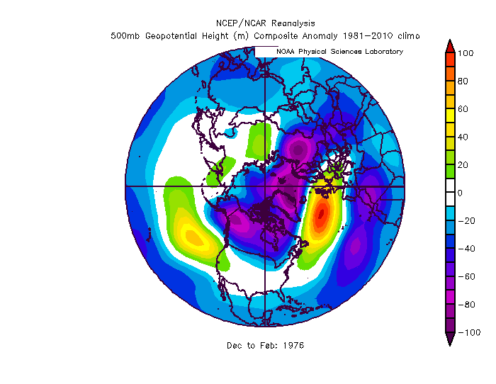
Looking at the h5 I don’t think that winter was bad luck. We rarely get much snow with a longwave pattern that features a raging +EPO/AO/NAO and WAR. That combo is a shut out the lights no hope don’t bother even paying attention pattern here. Even if we do get cold (and there were some chilly periods in 76) anything that amplified would cut in that pattern.
-
It's all about expectations. Right now I would be ecstatic if we got a repeat of 2018 or 2019 and a lot of people were complaining all through those years.
-
37 degrees and had a little mix with slush bombs during a heavier burst a little while ago.
-
Hate to be dark but deaths lag cases by about 3 weeks. 18.5 days is the average time from diagnosis to death and then add a few days for reporting delays. If you go back 3 weeks and look at the cases that correlate to the current deaths...and apply that same % to the current cases, we are looking at possibly 5,000 deaths a day around Xmas.
-
Para GFS was pretty darn good from 14 days. Was off on timing by about 18 hours...and was a bit too cold. Obviously the too cold part is the big deal...but still not a bad job there.
-
@Roger Smith 1976 was similar to last year around here...in that it was what we get when you have a raging +NAM and a crap PAC and ATL at the same time... no hope. The temps were colder that year due to a colder base state in general...but no way to get a frozen event and a favorable storm track in that setup.
-
You are kidding right? Hopefully this is you just having a dark sense of humor. 1976 was one of the absolute worst Nina winters in our area ever. It was virtually snowless in much of our region. DC finished with 2" for the whole season from a few very minor cartoppers...didn't even get 1" from a single storm all winter. The northern 1/3 of our region got a moderate snowstorm very late that winter in mid March...the rest of the region pretty much had no snow all winter except a few 1/2" naissance events. That year is a nina nightmare cautionary tale here.
-
Nice pics. With the Nina we knew a good winter was almost off the table. The signs the NAM state might not be as hostile this year leaves me hopeful we will have opportunities and this might be a more typical not great but not god awful Nina either.
-
True...but almost all the really good years have at least a snowy period somewhere in our area before New Years. Even 2015 I had a decent amount of snow here in November and early Dec before the torch set in. There are some super rare exceptions but 90% of the good years show themselves somewhat. Years where we get to Xmas with no snow anywhere in our region typically don’t end up being great years. But we kinda knew this wasn’t likely a great year already. And we could still get some decent events even if we roll into January with nada. And we could still luck into something in the next few weeks.
-
The rain held off until Xmas night I think. I remember Xmas day at my Uncle’s near Harpers Ferry WV sledding down the hill in his side yard with the kids. It wasn’t cold but it wasn’t a warm slop fest either.
-
@Ji I like your presence too. But if you throw your nonsense in the main thread then everyone else will too. Then the discussion thread ends up filled with nothing but complaining. And some aren’t even as funny or knowledgeable as you. It becomes a train wreck. Just post that stuff in here. We all read banter. We will see it. Then post your insightful stuff in the main thread.
-
If the nina does fade that could help on the PAC side...but the base state even before nina was pretty awful anyways. But as I hinted at above...if the atlantic side stays less hostile it will be able to compensate for the pacific more as we head later in winter. The NAO influence kind of peaks in Feb/Mar. If we are going to try to overcome a crap pac that is when to do it. March 2018 is a good example of that type pattern. Getting a similar type evolution but get it to set in say 2 weeks earlier and we could get a much better outcome.
-
If there is a silver lining...so far the atlantic side does not seem to be heading in a radically hostile direction. Unlike last year when both the pacific and atlantic were just hot garbage. I was never optimistic the pacific side would do us any favors. But if we are going to have a chance to overcome that...we will need a good period of blocking on the Atlantic side. We can get some opportunities as we head later into winter if the Atlantic side cooperates. December...not so much. That vortex over AK would be pretty hard to overcome even with everything else right until we get into January. But...if the Atlantic side stays less hostile we might have some hope for windows of opportunity later in winter. It's a low bar...but even that look there in the long range isn't quite as hopeless as last year when the pattern set in.
-
So sorry.
-
That pretty much sums up a typical day around here
-
Well...yea but we didn’t even need a high simply not that trough suppressing everything.
-
we would need there to be more separation then that there. There already is frankly on the guidance now but its still not quite enough.
-
Are you thinking of the Feb 21 storm? NYC got hit pretty good from that one. Some places in New England got some moderate totals from the Feb 15 2010 event. I think NYC had like 4"...but it wasn't that big a deal up there either. The Feb 21 storm though...that was a monster we just missed. But I had no issues with that...the whole period from late January to March kind of moved linearly imo. The block was at its strongest and healthiest in late January early Feb and each storm shifted a little north in progression from then on as the blocking slowly weakened. I agree the March 2010 storm has some similarity to this. It had two lobes diving into the trough and they ran interference on each other instead of consolidating the energy into one storm. This setup is somewhat similar.
-
of course having a high in a good spot is preferable. Our simplest path to snow here is overrunning. Anytime we get into needing a perfect upper level pass or phasing and all that jazz it gets complicated. We are a little too far south for all that to go easy for us...and often things come together just a little late for our latitude. But there are examples where things worked absent any real high. Off the top of my head the early Feb storm in 1995 had no high. I remember a storm in January 2001 I think where we got a decent snow with no high. The xmas day 2002 snow (our last true white xmas) had no high. The feb 2006 storm there was some really weak high in new eng but it was only like 1020 which is about what we have in this setup. There wasn't too much of a high, only like 1024 way up in Maine for the January 2011 storm. Sometimes we can work without. But yea it would make it a LOT easier with one.


