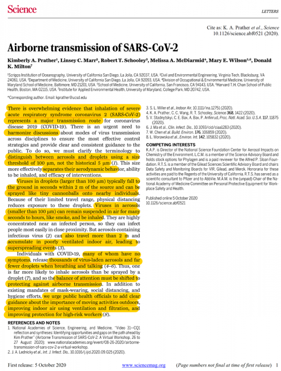
Baum
-
Posts
4,501 -
Joined
-
Last visited
Content Type
Profiles
Blogs
Forums
American Weather
Media Demo
Store
Gallery
Everything posted by Baum
-

November 30-December 2 *Potential* Winter Storm
Baum replied to Hoosier's topic in Lakes/Ohio Valley
I was referring to a gulf low moving north/northeast along or just west of the Appalachians. Irregardless, of folks who hinge on every model run. From what I can tell at this distance a good chunk of Ohio stands to get a decent early season snowfall. Seems rare to me. Not every storm is going to be the blizzard of'78. But if you don't want it blow it back my way. -
November 30-December 2 *Potential* Winter Storm
Baum replied to Hoosier's topic in Lakes/Ohio Valley
been awhile since we've seen something like this. Good sign for the upcoming winter...me thinks, -
November 30-December 2 *Potential* Winter Storm
Baum replied to Hoosier's topic in Lakes/Ohio Valley
better chance you'll be able to smell the snow that's falling 60 miles to your east on a stiff north-northeast gale. -
1979
-
local met in chitown buying in a bit. and this guy is fairly conservative...just to throw some more gas on the embers.....
-
It doesn't snow in Indianapolis. Easy toss.
-
congrats, madison.
-
LOT had the crew in. And that's okay.
-
agreed.
-
I'm much more a guy that's worried about 1-2" snow rates in Burlington,Iowa headed east-northeast into my neck of the woods in the next 3 hours versus what's happening in the Gulf of Alaska. I'm just not into the long game.
-
The flip to cold and snowy right around the holidays, after a mild November and early December, is always a good thing.
-
rockin the AC on November 10. This is a good sign for the upcoming winter.
-
your no Joe Bastardi..
-
not Halloween again
-
I like my long range maps to show "Possible Blizzard" over my area especially on holidays. A cold front doesn't do it for me.
-
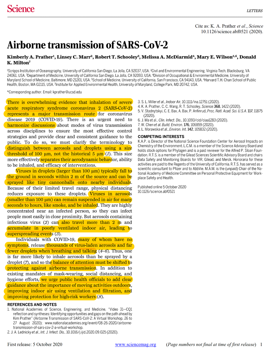
A new study just released yesterday regarding the particle size of the virus if folks are so inclined. Apologies if it was previously posted. My understanding is the particle size is relevant to the importance of mask wearing. Others here I'm sure are more schooled than I to it's relevance. Just trying to add to reasonable debate.
-
for this board, despite this particular thread "Dust in the Wind" maybe more fitting.
-
when do we begin the record breaking October heat wave thread?
-
worth the read out of Japan. https://www.medrxiv.org/content/10.1101/2020.09.21.20198796v1.full.pdf
-
I'm good with no Halloween snow.
-
i'm good with this until Thanksgiving. Than let's get a real December.
-
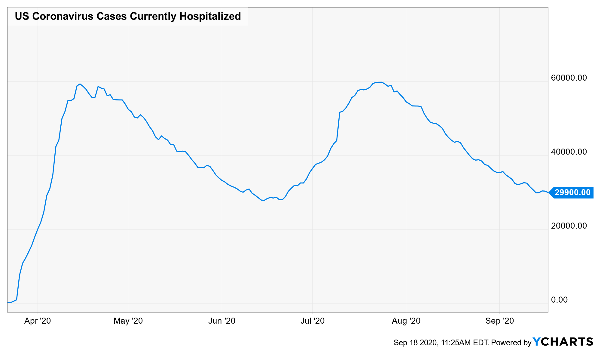
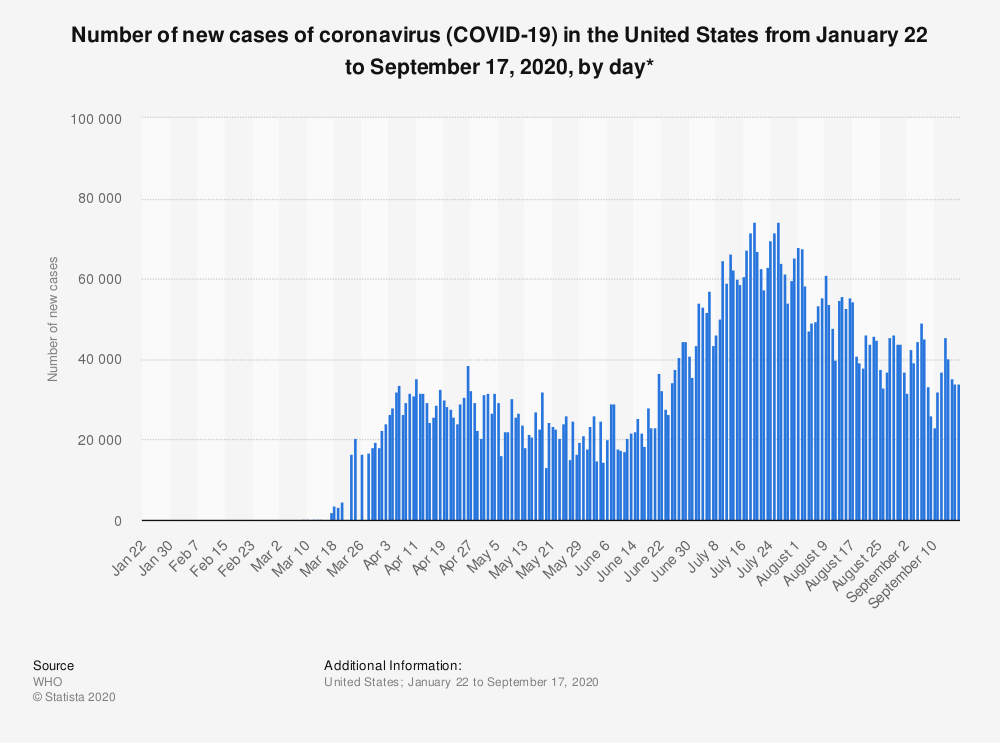
If cases and hospitalizations are your thing here is where we stand currently.

-
did you just curse us?
-
1977. Pre hoodie days. Just a KISS tee.
-
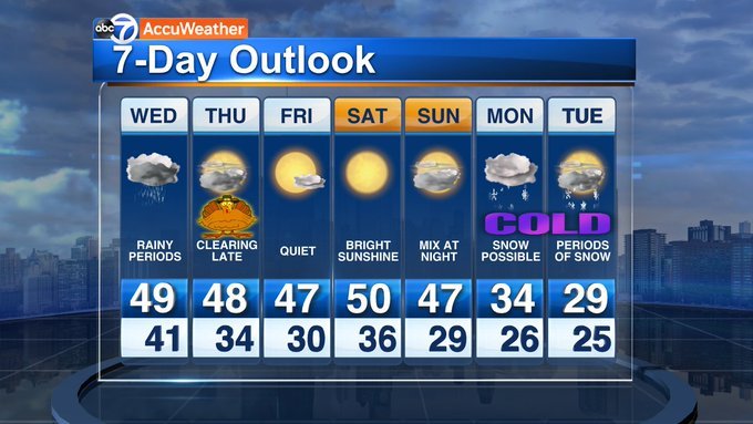
^ wow. CENTRAL LARAMIE COUNTY- INCLUDING THE CITY OF CHEYENNE 338 AM MDT SUN SEP 6 2020 ...WINTER STORM WATCH IN EFFECT FROM LATE MONDAY NIGHT THROUGH LATE TUESDAY NIGHT... TODAY SUNNY. AREAS OF SMOKE. HIGHS 90 TO 95. NORTHWEST WINDS 15 TO 25 MPH. TONIGHT CLEAR, COOLER. LOWS AROUND 50. NORTH WINDS 10 TO 15 MPH IN THE EVENING BECOMING LIGHT. LABOR DAY...SUNNY IN THE MORNING BECOMING PARTLY CLOUDY. HIGHS 80 TO 85. SOUTHWEST WINDS 15 TO 20 MPH SHIFTING TO THE NORTHWEST 15 TO 25 MPH IN THE AFTERNOON. GUSTS UP TO 35 MPH. MONDAY NIGHT RAIN IN THE EVENING, THEN SNOW POSSIBLY MIXED WITH RAIN AFTER MIDNIGHT. WINDY. MUCH COLDER. SNOW MAY BE HEAVY AT TIMES AFTER MIDNIGHT. MODERATE SNOW ACCUMULATIONS. LOWS AROUND 25. NORTH WINDS 15 TO 30 MPH. GUSTS UP TO 40 MPH IN THE EVENING. CHANCE OF PRECIPITATION NEAR 100 PERCENT. TUESDAY SNOW. MUCH COLDER. MODERATE SNOW ACCUMULATIONS. HIGHS 30 TO 35. NORTH WINDS 15 TO 25 MPH. CHANCE OF SNOW 90 PERCENT. TUESDAY NIGHT MOSTLY CLEAR WITH A 30 PERCENT CHANCE OF SNOW. COLDER. LOWS AROUND 15.