Baum
-
Posts
4,523 -
Joined
-
Last visited
Content Type
Profiles
Blogs
Forums
American Weather
Media Demo
Store
Gallery
Everything posted by Baum
-
fire it up...the dope....not the thread
-
May have broke the record for earliest it ever went dark on a 75 degree day as well.
-
I miss the 6 month out Holiday forecasts.
-
I hope I can make it: "THE UPCOMING COLD SNAP WILL NO DOUBT FEEL LIKE A SHOCK. BE SURE TO BUNDLE FROM HEAD TO TOE IN MULTIPLE LAYERS WHEN OUTDOORS THIS WEEKEND! " LOT AFD SATURDAY MOSTLY CLOUDY. HIGHS IN THE MID 30S. For most of us we move from T-shirt season to Flannel/hoodie season. No layers yet involved. Weather and fashion all in one post.
-
^ confirmed
-
I'm good with a nice November. After Thanksgiving bring on winter ala December 2000.
-
I didn't know Thundersnow became a you tube star.
-
wreck of the hardy palm tree guy. Love that tune.
-
Begonia's still rolling in my back yard.
-
yup, Dee just countered Alek's futility call.............ride it.
-
was in Petoskey,MI last week for the snow, returned home to an 80 degree weekend. Volatility FTW.
-
all in jest. I never really feel a certain storm track in October or November is a harbinger of winter cyclone tracks. Much more a pattern guy once we get later into November. Personally, would like to see a mild/dry pattern through a good part of November in hopes of change late month or early December. We're due for some weather around the holiday season.
-
^ establishing the train tracks of winter 2022/23 storms in October is also key.
-
spectacular year in these parts. Best I can recall. And the peak coinciding with neat 80 degree temps on a weekend is a rare feat. Suspect they will be clogging the storm drains tommorow.
-
from your backyard.
-
really going to enjoy the next three days. Guessing last prolonged warm spell until December. Might even take down the Christmas lights.
-
only guy on the board that drought and fire chases. Sicko.
-
kiss of death for breaking the recent trends of a mild and dry Decembers
-
Izzi about to bust to tame on his call.
-
" THEN CONDITIONS COULD BECOME VERY BAD. REASONABLE WORST CASE SCENARIO WOULD INCLUDE A PERIOD OF INTENSE (THUNDER?)SNOW WITH RATES >2"/HOUR (WHICH WOULD BE HEAVY ENOUGH TO ACCUMULATE ON ROADWAY), EXTREMELY LOW VISIBILITY, AND CONVECTIVELY ENHANCED WIND GUSTS OVER 40MPH. THE HEAVY, WET NATURE OF THE SNOW WOULD LIKELY STICK TO TREES WHICH ARE STILL LEAFED OUT WITH STRONG WINDS LIKELY DOWNING TREES LIMBS AND POWER LINES " I love it when IZZI goes rogue. Caveat:"THERE ARE A MANY UNCERTAINTIES AND POTENTIAL FAILURE MODES," Wonder who the next Met in the office gets to unravel "The Full Izzi" ?
-
"FOR ALL INTENTS AND PURPOSES, MONDAY'S WEATHER COULD EASILY BE A FORECAST ANY GIVEN DAY IN JANUARY!" - IZZIED sadly 40 degrees with a chance of flurries is not my idea of a great January day.
-
under the radar bust. LOT's Freeze Warning. Didn't appear to be close. Growing season continues....
-
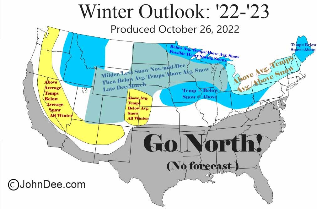
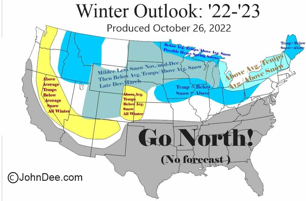
The BAM map looks more like a layout of each snowfal that fell in the LOT area last snowfall season. Minus the overdo in Mchenry county.
-
well, than they can't go wrong.
-
mumbo jumbo. If you could piece 5000 words together without actually saying anything of substance or commitment this fakecast stands out as brilliant.