stormy
-
Posts
1,570 -
Joined
-
Last visited
Content Type
Profiles
Blogs
Forums
American Weather
Media Demo
Store
Gallery
Everything posted by stormy
-
You better cross your fingers. The present trend is not your friend. 12z will give the bottom line.
-
A definite southward shift in Nam at 18z. D.C. now in the bullseye.
-
The EURO and GFS are on separate islands, about 100 miles apart. The Euro and UKIE are camped on the same island.
-
I love it !! This has been my conviction for 30 hrs. now. This thing is trending north. AS I have posted since noon yesterday, mixing will be a HUGE issue ......................................
-
The ICON is what I have been trying to communicate in the last 24 hours. Accurate? Who knows
-
I dropped from 9.3 at 06z to 5.0 at 12z on the Euro. It caved toward the GEM and GFS with the southern margin. It dropped qp in my area from .95" to .69"
-
The GFS is very erratic with the movement of low pressure from western Tennessee/Kentucky to the east coast. This must be clarified with future runs to determine who gets what.
-
If the 50/50 weakens it will cut. The 06z ECM actually shifts the 50/50 slightly west and slightly increases ne confluence , hence the slight southward shift.
-
January: Medium/ Long Range: May the Force be with Us....
stormy replied to Weather Will's topic in Mid Atlantic
Like a wall! The precip. cant' get across the mountains ................................................................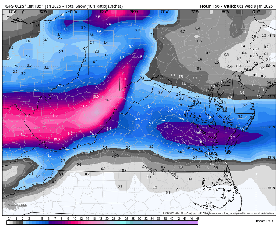
-
January: Medium/ Long Range: May the Force be with Us....
stormy replied to Weather Will's topic in Mid Atlantic
The ICON greatly diminishes Mondays potential....................... DROUGHT??................. -
January: Medium/ Long Range: May the Force be with Us....
stormy replied to Weather Will's topic in Mid Atlantic
Euro shifts north 50 - 75 miles with 12z. Not good because Miller B's are notorious for serious mixing issues. No more of this!! Get back down in Tennessee and North Carolina. -
January: Medium/ Long Range: May the Force be with Us....
stormy replied to Weather Will's topic in Mid Atlantic
A shift in the right direction!! Be patient............. I'll take my 3 inches and be happy. -
January: Medium/ Long Range: May the Force be with Us....
stormy replied to Weather Will's topic in Mid Atlantic
Excellent point!! -
January: Medium/ Long Range: May the Force be with Us....
stormy replied to Weather Will's topic in Mid Atlantic
The GFS was suppressed south which is no big deal at this point. The GEM is also suppressed south which brings it right into my backyard. -
January: Medium/ Long Range: May the Force be with Us....
stormy replied to Weather Will's topic in Mid Atlantic
12z GFS more amped. -
January: Medium/ Long Range: May the Force be with Us....
stormy replied to Weather Will's topic in Mid Atlantic
Very simple! Trash the 18Z GFS and look forward to 00z -
.32" so far. Warmer today, 56 at 9:30.
-
January: Medium/ Long Range: May the Force be with Us....
stormy replied to Weather Will's topic in Mid Atlantic
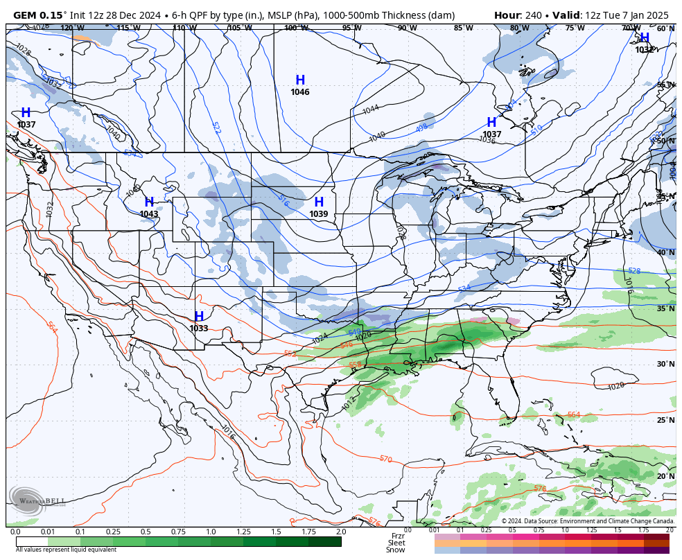
The GEM saves us at 270: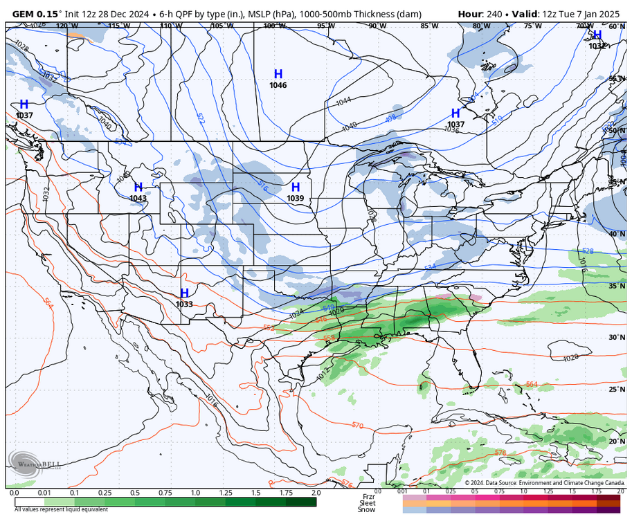
-
January: Medium/ Long Range: May the Force be with Us....
stormy replied to Weather Will's topic in Mid Atlantic
Not always but will often trend in that direction. In January of 66, I received 16 inches of snow in one storm that found heavy snow falling with a 3 pm temperature of +4! Coldest I ever witnessed in the middle of a snowstorm!! -
January: Medium/ Long Range: May the Force be with Us....
stormy replied to Weather Will's topic in Mid Atlantic
That can happen east of the mountains. 76 - 77 was possibly the coldest winter in 200 years but was often suppression city . The AO was -2.07 in December of 76, -3.76 in January of 77 and -2.01 for February 77 Read all about it: https://www.secretsoftheeasternshore.com/eastern-shore-deep-freeze/ The 1976–77 Winter in the Contiguous United States in Comparison with Past Records in: Monthly Weather Review Volume 106 Issue 10 (1978) -
January: Medium/ Long Range: May the Force be with Us....
stormy replied to Weather Will's topic in Mid Atlantic
The AO tanking to -3.00 to -4.00 is classic for historical severe patterns. 09 - 10 it tanked to -3.41 with an NAO -.1.10. The PDO was -.50 The AO is almost always the deciding factor. 77-78 found the AO tanking to -3.01 with an NAO of -.12. The PDO was +.50. -
January: Medium/ Long Range: May the Force be with Us....
stormy replied to Weather Will's topic in Mid Atlantic
The CPC January temperature anomaly along the east coast is being destroyed by the 6 - 24 day.
-
It has been cold! Forecasted high from NWS was 46. Actual high was 41!!!! This is 5 degrees colder than normal.
-
January: Medium/ Long Range: May the Force be with Us....
stormy replied to Weather Will's topic in Mid Atlantic
Last Sunday at 4:22 pm I said that Jan. 3-8 was a 5 day threat period.............................. To bat 1000, I think that I will stand pat.................. -
January: Medium/ Long Range: May the Force be with Us....
stormy replied to Weather Will's topic in Mid Atlantic
Ain't it sweet