stormy
-
Posts
1,991 -
Joined
-
Last visited
Content Type
Profiles
Blogs
Forums
American Weather
Media Demo
Store
Gallery
Everything posted by stormy
-
I commented on this in the tropical thread 15 minutes ago. Predictor radar indicates the eye will cross the coast 10 - 15 miles east of NHC plot.
-
Predictor radar indicates the eye will cross the coast 10 - 15 miles east of NHC plot.
-
Mts. of western N.C. above 4000 ft. could have gusts to 80 mph late tonight and Friday morning.
-
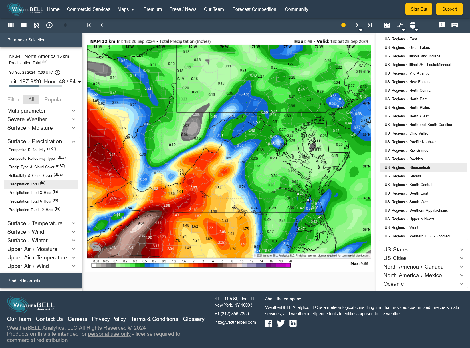
Two days straight the 18z NAM wants to keep DC East dry.

-
2.67" rain last night!
-
Latest 18z NAM gives me 1.76" from Helene and D.C. nothing......................... I hope this is wrong because D.C. could use a drenching.
-
I have been watching that H5 lp rotate east from Superior to Maine and north Atlantic all week knowing that it controlled the ultimate trac of future Helene. Southwest suppression will likely control the agenda. Latest models believe I may get an inch with D.C. perhaps a half inch. Moderate to severe drought continues in Augusta though recent rains have been very beneficial to top soil moisture. The water table continues to drop, down 12 ft. since late May.
-
The AI model is out on a limb because the others maintain an omega block. 12z will be interesting. With the block, ECM gives southwest zones .90, GEM .50", GFS .12" (deadstop at Roanoke will change)
-
The Omega Block no longer exists on the 6Z AI............. That's why Helene tracks to Hatteras instead of Cincinnati.....................
-
Western areas in the 81 corridor should have a wet week. East of 95 closer to the coast not so much.
-
Nearly equal at .79"
-
The trough amplified this afternoon, therefore the heading of 120 shifted to 190, forcing activity west of my location. .01" here and 1.05" 15 miles southwest.
-
I was clear this morning. It was pea soup yesterday morning til about 11. If yesterday had been August 15, that would have been a nice snowstorm in January.
-
The latest HRRR gives me 1.46" rain later today and D.C.- 0.................... NONSENSE!
-
The more you pay attention to the models, the more you realize that they all often stink.
-
3.05"...................... A few locations within 15 miles report over 6.00 inches!! Others, less than an inch.........
-
1.00" in the bucket at 12:15.
-
The batting average on this range will be 1000
-
.27" in the bucket at 8 am. My 8 model blend thru Friday has increased from 1.28" to 1.50".
-
Will: I would suggest that you look at the NAM 3 k This is likely closer to reality.
-
Its not all that complicated. The blocking ridge to our north is simply too strong for Eight to move north into Virginia. N.C. gets the lions share of the rain. Southwestern locations in my backyard should do better than D.C.. My 8 model blend has increased from 1.23" at 6 am to 1.28" at 2 pm.
-
I have been interested in watching the AI with curiosity about possible future superiority compared to physics based models. A comparison of the last 4 runs is not impressive.
-
The AI caved to the GFS and about an inch of rain.......................... The war between a strong ridge to the northeast and tropical/hybrid low pressure shifting northwest from Cape Fear will have the final word. Of interest, the ICON has jumped from .25" for Augusta to around 4.00".
-
The most important part of your interpretation is that "the ridging to the north is likely to prevent an escape route". This can be very important for rain producing systems or snow producing systems in winter. Historically, when the right combo. occurs with blocking to the north, look out.
-
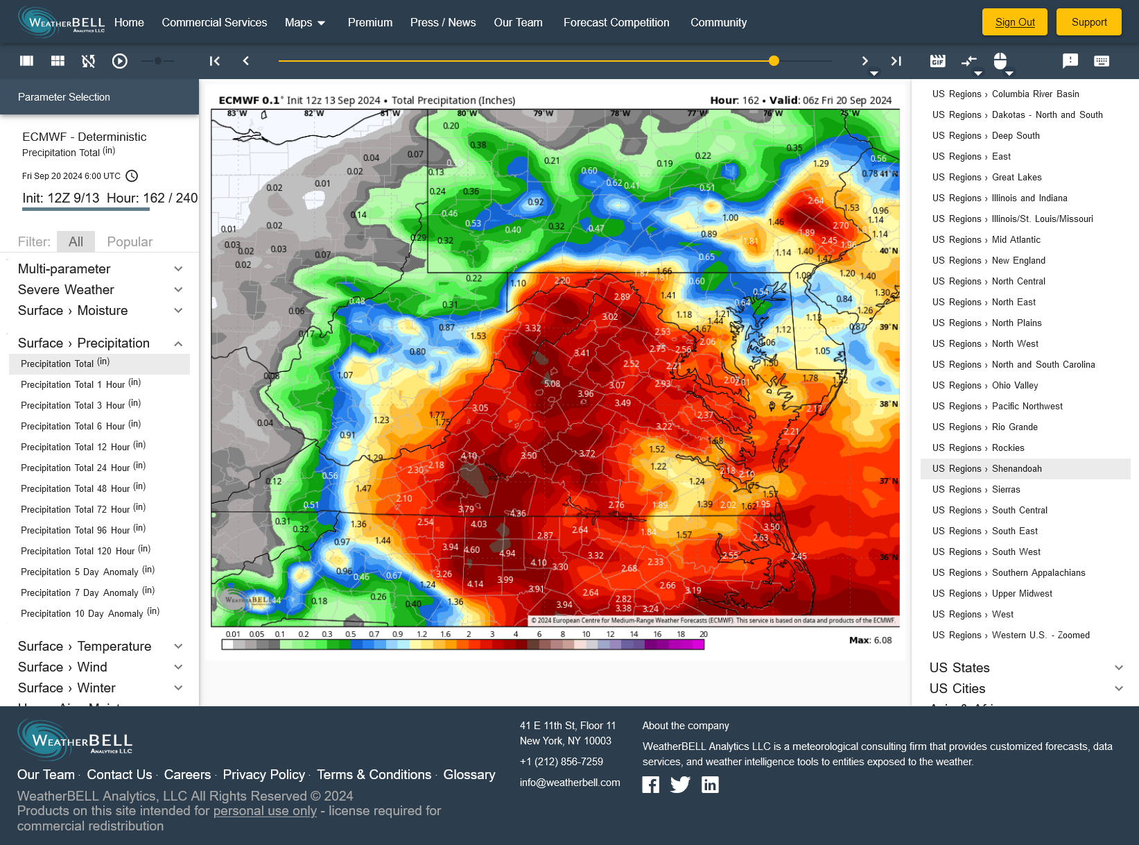
12Z EURO comes out it drought trance and gives me 5.00 inches next week compared to .05" from 06Z