stormy
-
Posts
2,102 -
Joined
-
Last visited
Content Type
Profiles
Blogs
Forums
American Weather
Media Demo
Store
Gallery
Everything posted by stormy
-
make that wind 7 - 15
-
2 inches at 1:30, 23.5 degrees with a northeasterly breeze at 7 - 5.
-
1.25", moderate snow, northerly wind 10 - 20 mph, 25.1 degrees. It has fell 7 degrees since 7am.
-
Snow began at 5 am with 32 degrees. 8:30- 30.9 degrees with moderate snow and .70". My 4 model blend is 3 inches and Kuchera is 5.0" Kuchera may be more accurate because GFS and NAM say 850mb 14 F at 1 pm which gives a ratio of 15 - 20: 1
-
May the grace of God be with you, your family and wife. I lost a very special friend to the big C a few years ago. She was robbed of a beautiful life much too soon. Hopefully, your wife can beat this bastard.
-
HP over Chicago 12z Monday will allow northward transition of southern moisture more efficiently than southern suppression from Scranton/NYC HP Thursday night. It could make a difference.
-
18z GFS shifts north with possible Monday snow.
-
The NAM is often the black sheep, but under 48 hrs it can signal a trend.
-
18z NAM shifts north for Monday
-
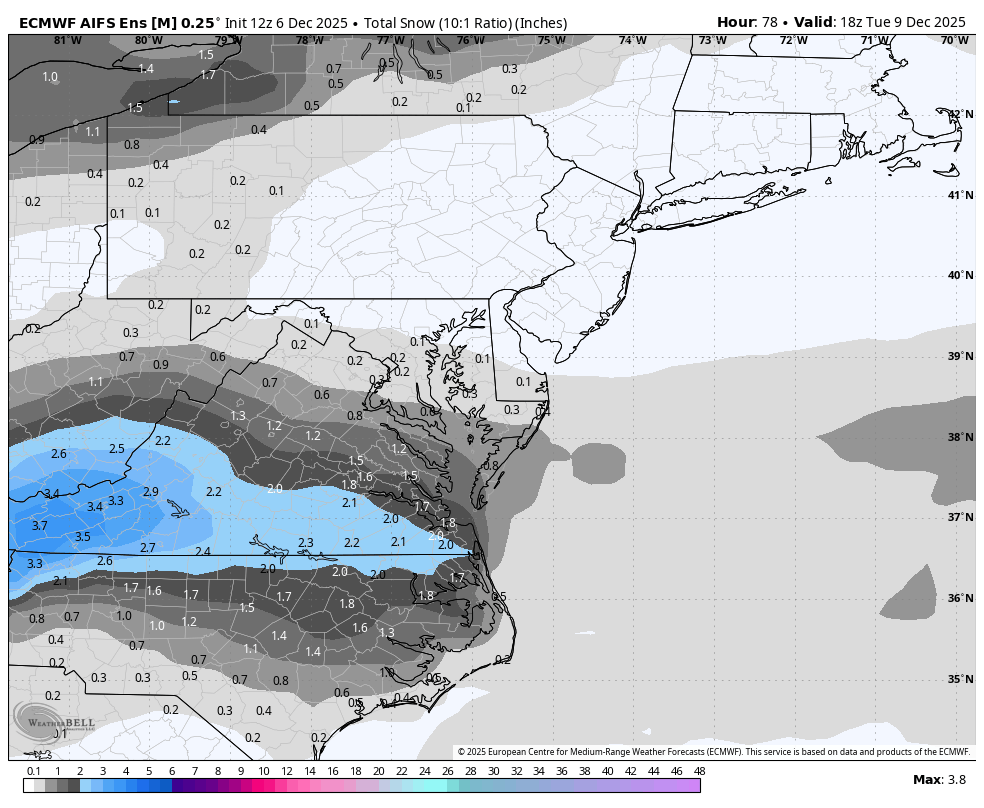
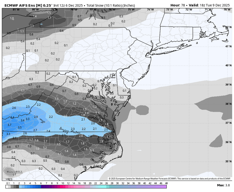
I like the Euro AIFS ens. Tuesday was wacky but it performed very well on Friday. I can handle 1.5" and be happy.
-
Wednesday's 3 inches makes 10 times in the last 45 years that Augusta County has received winter events on December 5!!!!!! The others: 2018 - 1.5" snow, 2009 - 6" snow, 2007 - .8" snow, 2005 3.0", 2003 - 6.5", 2002- 5", 1996 3.0", 1985 .50", 1984 - 1 " sleet
-
3.0 inches north side of Waynesboro. Got my driveway plowed out. Still flurries falling. 28 degrees.
-
Light snow has started at Staunton/Waynesboro with 30.3 degrees.
-
My 4 model blend increased from 1.6" at 8 am to 2.4" at 1 pm.................... I will predict 2 - 4 inches for Augusta in my newsletter a little later, with snow developing 1 - 3 am. For D.C., my thoughts are .5" - 1.0" with flurries by 5 - 6 am.
-
Congratulations Terp.!!
-
Unfortunately, this map from the WPC says it all.
-
Yes, much of the east coast was wrecked.
-
Yes, 18z gives me 1.6" compared to 12z at .7"
-
I remember that Great Ash Wednesday storm.
-
We'll be close to a 50/50 but the trajectory of the HP is a little south of ideal at Ogdensburg.
-
One great reality is that 850 temps. should not be an issue on Friday.
-
Sunshine and 40 degrees at 1pm.
-
That's a nice bump from 3.7 to 8.8".
-
.20 zr and trace of sleet. Rds, minor to moderate. 32.1/31 The person who composed the AFD from Sterling this morning is about 12 hrs. slow with the threat on Friday. "The system may spread some very light precipitation on its northern side Friday night before pushing offshore on Sat." Under slept?? The Blacksburg AFD is spot on, "Next system moves in Friday morning, snow transition to wintry mix possible". That tracs the Euro.
-
Patience is a great virtue.