

stormy
-
Posts
2,095 -
Joined
-
Last visited
Content Type
Profiles
Blogs
Forums
American Weather
Media Demo
Store
Gallery
Everything posted by stormy
-
I have been amused with some on this forum who are obviously ignorant of this present reality. If this does not change, the coming summer will be parched toast. Is no one concerned when so many seem to be concerned about "why it doesn't snow anymore"..... This is a farcical joke!! The enso shift will probably intervene. I have observed a 6 month lag in enso shift to reality. This 6 month lag encourages an increase in rainfall by late summer and a better winter next year for the snow-lovers.
-
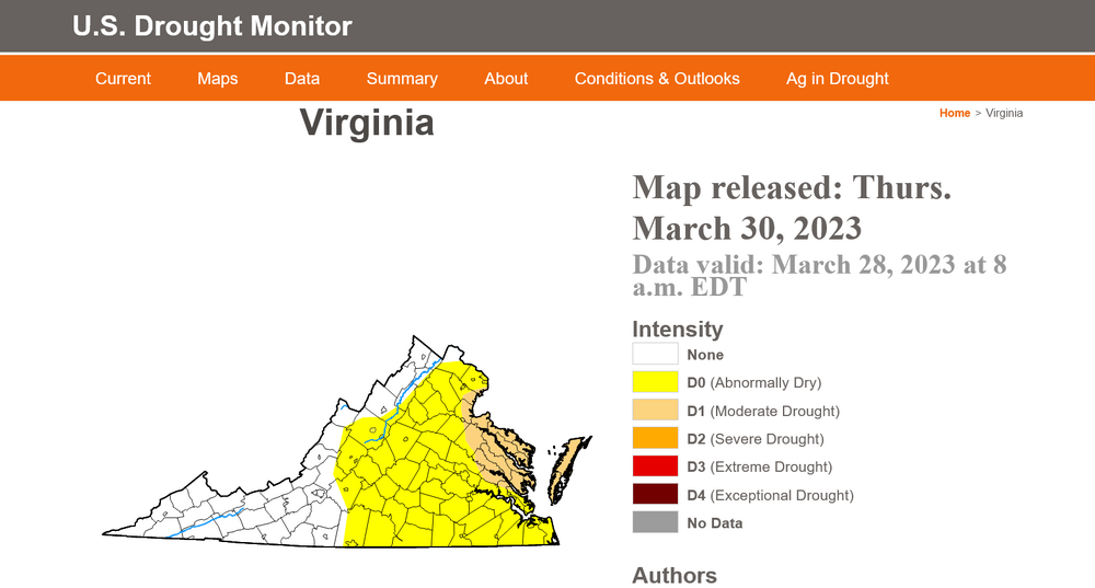
A portion of east-central Virginia was upgraded to moderate drought this morning!
-
Yes, it has been very dry for the last 30 days south, southeast and southwest of D.C.. Many areas only 25 - 50% of normal. Only areas with normal precipitation are northwest of D.C.. The U.S.D.A. Drought Monitor lists D.C. proper as being abnormally dry. During the past two weeks the percentage of Virginia abnormally dry has increased from 4% to 23%. If this pattern continues, many will be evolving into drought conditions during the spring.
-
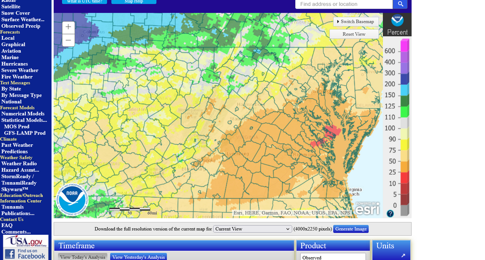
WPC not optimistic about rain during the next 7 days
-
My storm total is .33". That puts me up to .98" rain and melted snow for the entire month of March. My 40 year normal for the first 25 days of March is 2.79"
-
.18 rain since yesterday morning out in the Valley. Thankful for every drop.
-
.04" rain last 24 hours
-
Only 25% of normal rainfall to date in March in Augusta. Prominent SER threatens potential rain through Saturday.
-
I agree with you 100%. I have been attributing my observed propensity for a prominent SER to a Nina state for nearly 3 years. I will be alarmed if a Nino allows a prominent SER next winter! I despise Nina's because they usually result in below normal rainfall for my area. 2021 was over 11 inches below normal. 2022 was only 1 inch below normal but we had precip. suppression during the winter when potential snow producing systems approached. The answer to our mystery is being able to accurately identify why the SER is so prominent in today's world.
-
17 .1 this morning out in the valley
-
The SER has been a pest all winter. This is not always but a frequent reality of La Nina. NOAA is projecting a 1.0 + El Nino for next year. I am interested in your thoughts for next winter based on a 1.0 + El Nino.
-
You create an interesting consideration for me and I appreciate your thoughts! You are obviously thrilled with your battery powered lawnmower. I made the transition to battery powered drills, screwdrivers in small tools years ago and I love them. I recently had a friend encourage me to think about a battery powered chainsaw. He says that a commercial grade heavy duty saw does an amazing job.
-
I would be very happy if life brought me a lot of this for the next few months
-
I recorded VERY COLD 7 am at 12.1 on my Davis Vantage VUE and 13.1 on my Taylor. A lot of peach fruit buds frozen.............. Probably 80% at least.
-
The forecast discussion from Sterling this morning indicated that most of our region is 3 - 4 inches below normal precipitation ytd. I have a live stream running through a portion of my property. Usually, high water levels from heavy rains flush out siltation prone channels at least once a year. It has been 3 years since heavy rains produced water levels high enough to flush these channels. We get light to moderate rains occasionally but not heavy enough to produce run-off.
-
-
Keep the faith my good friend. You will be fine over the next several years. These short term cycles have repeatedly occurred over the past 100 years.
-
sleet would be ok. I'm hard up after only 1.25" of snow the entire winter. At least sleet is frozen!! Of course, I did receive 9" of snow on April 7,1971 and 7 inches on April 7, 1990. I would be more confident with a Miller A and 1040 hp over Ontario.
-
10.5 inches would make my winter out here in the valley.
-
I absolutely don't dispute short term trends. We have those many times over the past 20, 50 or 100 years. The inconvenient truth is that we don't have long term trends because as I said earlier, they do not exist. I deal in facts, not innuendo. Yes, D.C. has had a general 7 year period of below the normal snowfall of 13.8", though last year was close at 13.2". 18-19 was a 1 year blip upward above normal at 16 .9". Technically and factually, 6 of the last 7 years have been below normal. Previously, 2013 - 2016 was a 3 year period of above normal snowfall, 32.0", 18.3" and 22.2". 1926 - 1932 was a general 6 year period of below normal snowfall, though as in this recent short term trend it had 1 above normal year, 1929-30 at 18.1". 26-27-4.3", 27-28 11.1", 28-29 7.5", 30-31 2.5", 31-32 5.0". These short term trends continue as they have for a long time. If this continues for another 3 winters it will be safe to say that the trend is a very unusual long term anomaly. I do not personally attack others no matter how much I may disagree. This should be an honest and free forum as long as excessive profanity or verbal attacks are not directed toward others.
-
You are exactly right! We just went through a drought winter for snowfall but in all likelihood it will be better next year. To repeatedly make proclamations about how warm it is and insinuate we may never return to the way it used to be is demoralizing to many and certainly not productive. The chart that I posted a little while ago was not intended for illustrating long-term trends. Why would I be so foolish because long-term trends DO NOT EXIST. If we are consistently below normal for the next 50 years, then talk to me about long-term trends. That chart was simply to illustrate up and down cycles in snowfall. About this chart, PSU said " Its fine for showing up and down cycles of snowfall" Thank you
-
An interesting chart showing D.C. winter snowfall anomalies back to 1949. This reveals that the most consistent below normal stretch of winters occurred in the early to mid 1950's and again around 1990.
-
How snow is measured has a tremendous impact on totals. I notice this often in my area when looking at totals and one person is 3 inches above others a mile away. This is the guy who walks out in the middle of an unmanicured lawn with 6 inches snowboard snow and pushes a yardstick down until he reaches hard ground and is thrilled with his 9 inches of snow!
-
This perfectly illustrates the huge departure from normal in the mountains of W.Va. Percentages would have been more user friendly but this gets the job done. Thanks for posting this!
-
I had 19.25" for 20-21. Not bad. Interesting variables between D.C. and the Valley. D.C. / Baltimore have often received much more summer rain in recent years than the Valley, yet much less snow in winter.


