

stormy
-
Posts
2,000 -
Joined
-
Last visited
Content Type
Profiles
Blogs
Forums
American Weather
Media Demo
Store
Gallery
Everything posted by stormy
-
The GEM at 240 could be on to something. Southern Arkansas to Myrtle Beach. This is not far from where the EURO was 24 hrs. ago. Verification at this range is comparable to the GFS.
-
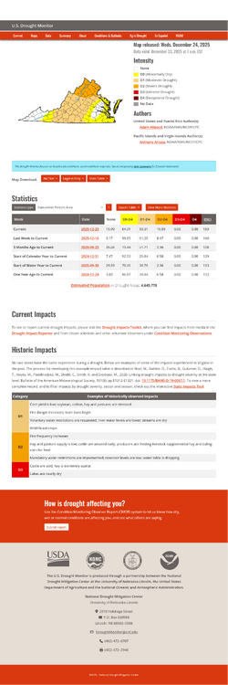
Unfortunately, the GFS believes that the drought persists for at least another 10 days..............
-
Hey Ji : That's about the same time-frame as the 00z GFS event.
-
Lets hope that the last half is rip-roaring!
-
54 degrees at 7 am with a southwest wind of 18 mph.
-
The southeast ridge pours cold water on the 00z GFS.
-
Southern Arkansas to Norfolk on the deterministic is reminiscent of tracks from January 1966. Other pieces of this puzzle not fitting together. AI and EPS don't like northern Va.. I was hoping to be able to feature in my Monday Newsletter Edition but I'm losing confidence.
-
And the latest Canadian ensemble maintains the same drought region for the next 10 days:
-
For you, it is a difficult question................ For others, it is a simple conclusion
-
To answer your question............... NO................ Snow results from precipitation when the 5000 ft. temperature is below 32 F.
-
JI - I have respect for your opinion........... I will do an in depth comparison of these variations and let you know.
-
24 hours ago the NWS POP for Augusta on Monday was 60%. This afternoon it has plunged to 20%....................... The Drought controls..................................................
-
Your wisdom is impressive. A lot of bullish hype in here this afternoon but I believe most don't understand or admit how difficult serious Drought is to overcome. That southern jet needs to be on steroids..............................
-
I have been comparing operational to ensembles for a long time. The ensembles have often been too bullish on precip. for Augusta that never materialized. Too many opinions. AI may be the trend for the future, but again, the AI ensemble snow prediction was nuts not long ago.
-
We can only hope
-
One last shot: Dry first 10 days of January vs. CPC Wet
-
This is the map that I was using:
-
The CPC now says trending WET January 1 - 9. The Euro and GFS says trending DRY Jan. 1 - 9. Who would You put your money on? The CPC has been wrong for so long, they gotta be right some time. OK CPC, I believe.
-
Euro AI keeps the 6/7 system down in N.C..
-
The Severe Drought now extends from Rockingham through D.C. When will it end?? El Nino coming on in 2026 gives hope.
-
There is no such thing as a consistent top performer. Most would consider the ECMWF and GFS as leading the pack, but neither one is a consistent winner.
-
MERRY CHRISTMAS to everyone............... I'm happy because I received .21" rain early this morning. Was supposed to be less than .10" Gotta run to celebrate with friends and family the rest of the day........ A whole lotta calories.
-
Remember this.............. Persistence can be a very good thing. How many times has a threat looked good on one run and been gone the next run??
-
That"s fine! You're good! For those who may seriously be disgruntled because of the 12z run of the GFS, take heart. Yes, hp was weaker and qp less, but this is 4 days away. As long as it holds on to the general idea, we have a long ways to go.
-
What folded?


