PhiEaglesfan712
-
Posts
1,415 -
Joined
-
Last visited
Content Type
Profiles
Blogs
Forums
American Weather
Media Demo
Store
Gallery
Everything posted by PhiEaglesfan712
-
E PA/NJ/DE Winter 2025-26 Obs/Discussion
PhiEaglesfan712 replied to LVblizzard's topic in Philadelphia Region
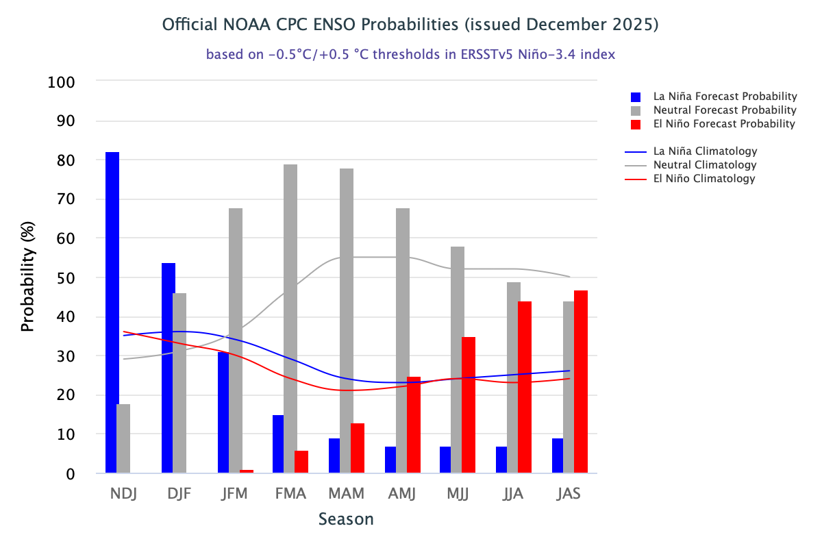
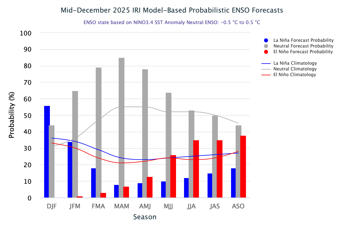
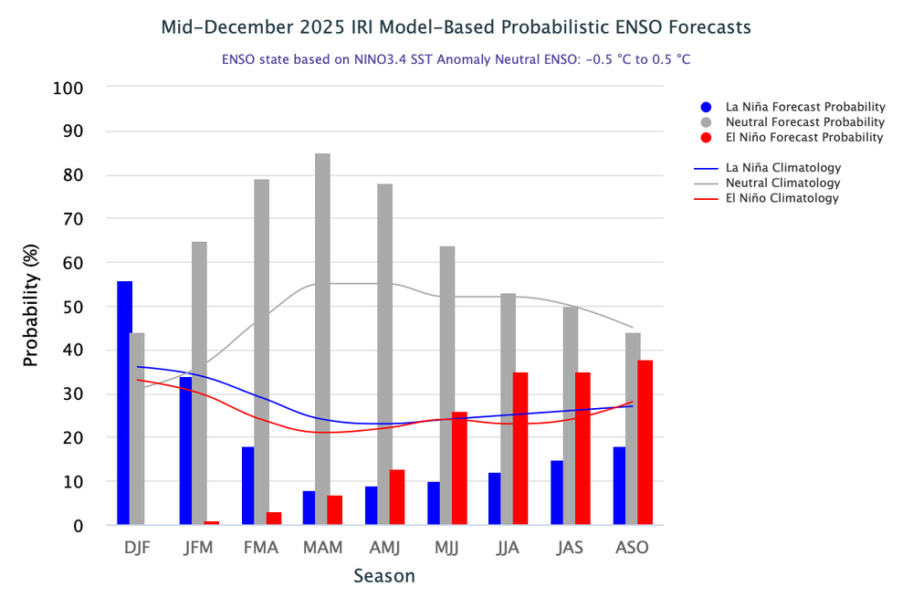
If we don't get one by January 19, then we're going to have to wait a long time for the next snowstorm. I get the feeling we're going to see above average temperatures by the time we hit mid-January. -ENSO/-PDO/-IOD years don't go all the way through December and January cold. That's something that happens in a +ENSO or +PDO winter. -
I can't wait for days when it's 80 and sunny out. March 29 was easily the best weather day of this year.
-
2025-2026 ENSO
PhiEaglesfan712 replied to 40/70 Benchmark's topic in Weather Forecasting and Discussion
NYC has not had a 4" snowfall since the January 28-29, 2022 snowstorm. -
2025-2026 ENSO
PhiEaglesfan712 replied to 40/70 Benchmark's topic in Weather Forecasting and Discussion
Thing is, 2010-11 had a very relaxed Pacific jet (we haven't had that since 2013-15). That's why December and January went all the way through cold. And the west wasn't really that warm in 10-11 (like we had in 13-14 and 14-15). Without a relaxed Pacific jet, I expect things to torch at some point in January. Coldest case scenario is January 2018, which was near normal. February is going to torch. (Sorry for those who love cold, but that's how -ENSO/-PDO/-IOD years tend to work. You just have to hope that winter returns in March. That did happen in 2017 and 2018, and even to a lesser extent, the last week of March 2011.) -
lol, this obs is way too cold. I can't wait to see obs posts like this again: "Here in East Nantmeal we are already up to 73 degrees here at 1030am." "77F Trash cans went dancing" "Am actually sitting at 82 at post time." "81F With the clouds, low DP, breeze...not bad at all out there." "80F" "Had a couple raindrops then a pretty cool sunset. Maybe some showers late tonight / early morning? 74F/ breezy" "We reached 82.2 degrees here in East Nantmeal this PM"
-
2025-2026 ENSO
PhiEaglesfan712 replied to 40/70 Benchmark's topic in Weather Forecasting and Discussion
Temperature departures like this is something you see in a +ENSO or +PDO season, not a -ENSO/-PDO/-IOD. There is definitely going to be a pattern change in January. At a minimum, either the Western US will turn cold or the Eastern US will turn warm. -
That has no correlation. NYC cashing in on a snowstorm doesn't mean everyone is going to win come January. For all we know, DC could end up with a final season snow total of 3-4" (see below). That season had one of the oddest snow distributions ever. Places in upstate NY finished the season with over 150 inches of snow, while places like Baltimore and DC finished with less than 4 inches of snow.
-
Sometimes, the models get it right. The best forecast this year was from the Euro (and just about every other model than the GFS) locking in the March 29 warming event 4-5 days out. (The GFS showed temperatures in the 30s instead.)
-
2025-2026 ENSO
PhiEaglesfan712 replied to 40/70 Benchmark's topic in Weather Forecasting and Discussion
Just like a weather pattern, these things can really turn on a dime. I thought gold and silver still had a lot of room to grow in summer 2011, but that was the peak, and the price went down for years. (Thank goodness I didn't buy.) -
I'm down for days like March 29, 2025, when it was 80 and sunny.
-
I don't think so. That was the day my brother and sister-in-law got married. I remember it being 70 and sunny in the morning, maybe a little breezy and cloudy in the afternoon during the ceremony, but no tornado.
-
2025-2026 ENSO
PhiEaglesfan712 replied to 40/70 Benchmark's topic in Weather Forecasting and Discussion
This map is very reminiscent of fall/winter 2010-11. Of course, we had a very relaxed Pacific jet that year, which explains why we went cold in the East all the way through December and January, despite their being a deep -ENSO/-PDO/-IOD. Even when things moderated out in February and March 2011, those months weren't particularly that much warmer than average. (We eventually got the warmth that year, from April-July.) We don't have a relaxed Pacific jet this year (at least I don't think), so I'd be shocked if went cold all of January. I expect a reversion to the mean, and a torch to start at some point in January, continuing into February. -
2025-2026 ENSO
PhiEaglesfan712 replied to 40/70 Benchmark's topic in Weather Forecasting and Discussion
Yes, but I'm very skeptical of this snowstorm. They were predicting 50s on Friday until of a sudden yesterday morning, now they're predicting 30s and snow. -
2025-2026 ENSO
PhiEaglesfan712 replied to 40/70 Benchmark's topic in Weather Forecasting and Discussion
They're saying a snowstorm is going to happen. I don't know to believe it. Fun fact: On March 29, 2025, widespread upper 70s/lower 80s were observed in our area. -
2025-2026 ENSO
PhiEaglesfan712 replied to 40/70 Benchmark's topic in Weather Forecasting and Discussion
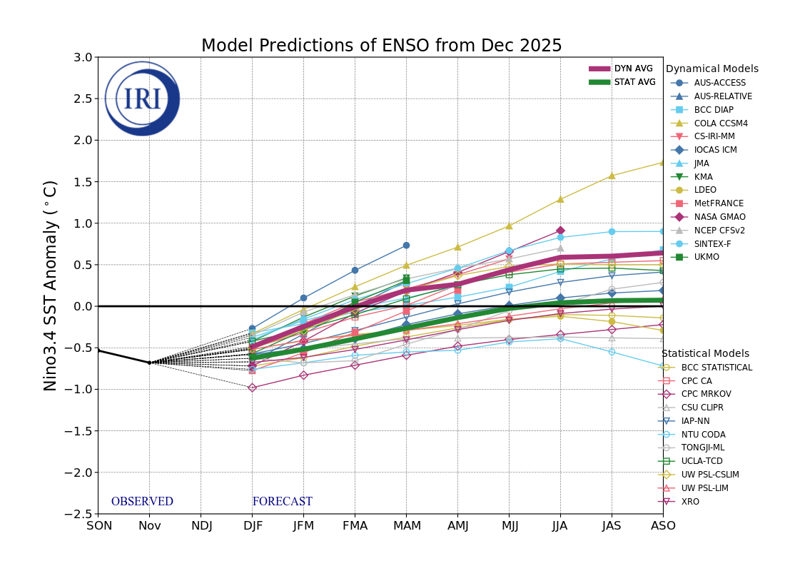
It looks like we go warm by the 2nd week of January, which makes sense, considering we haven't had a December and January go all the way cold since 2010-11: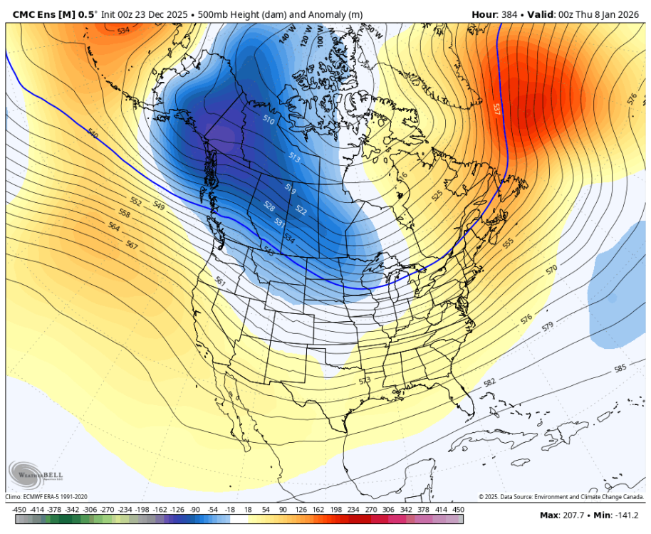
-
2025-2026 ENSO
PhiEaglesfan712 replied to 40/70 Benchmark's topic in Weather Forecasting and Discussion
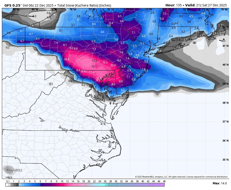
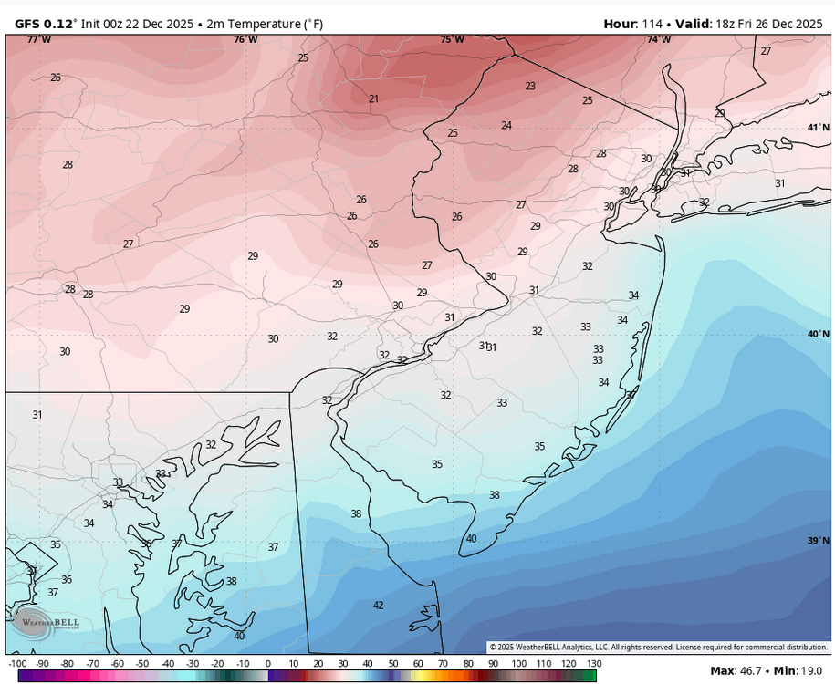
March 29, 2025 (5 days out): December 26, 2025 (4.75 days out):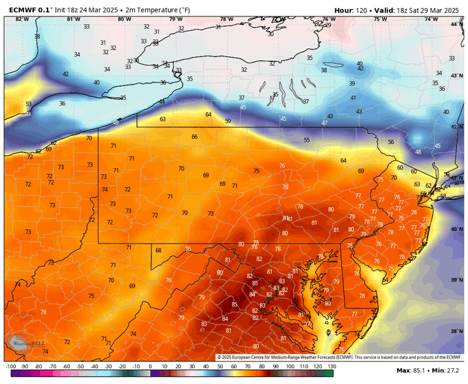

-
What about the 12/26/2010 snowstorm?
-
2025-2026 ENSO
PhiEaglesfan712 replied to 40/70 Benchmark's topic in Weather Forecasting and Discussion
lol, January isn't coming close to 21 inches of snow. The snowiest January since the 2016 storm was 2022, and that was 15.3 inches, and 2018 is the only other year since then that has even topped 10 inches. I'd be willing to bet that January ends up with less than 10 inches of snow and an above average temperature departure. -
E PA/NJ/DE Winter 2025-26 Obs/Discussion
PhiEaglesfan712 replied to LVblizzard's topic in Philadelphia Region
80 degrees on 3/29/2025 was the best model forecast of the year: -
E PA/NJ/DE Winter 2025-26 Obs/Discussion
PhiEaglesfan712 replied to LVblizzard's topic in Philadelphia Region
Just like I did on 3/29/2025, when in doubt, go the the NWS, which says too warm for snow: Christmas Day A chance of rain before 1pm. Cloudy, with a high near 44. Chance of precipitation is 30%. Thursday Night A chance of rain after 1am. Cloudy, with a low around 39. Chance of precipitation is 30%. Friday Rain likely. Cloudy, with a high near 57. Chance of precipitation is 70%. Friday Night A chance of rain before 1am. Mostly cloudy, with a low around 39. Chance of precipitation is 30%. Saturday Mostly cloudy, with a high near 51. Saturday Night A chance of rain. Mostly cloudy, with a low around 39. Chance of precipitation is 30%. Sunday A chance of rain. Mostly cloudy, with a high near 51. Chance of precipitation is 40%. -
E PA/NJ/DE Winter 2025-26 Obs/Discussion
PhiEaglesfan712 replied to LVblizzard's topic in Philadelphia Region
The miracle White Christmas in 1998. Temperatures really torched that month, with 2 days in the 70s in the first week, and temps in the mid-60s as late as the morning of the 22nd. Then, temperatures fell throughout the day, leading to the snowstorm on December 23-24, 1998. -
2025-2026 ENSO
PhiEaglesfan712 replied to 40/70 Benchmark's topic in Weather Forecasting and Discussion
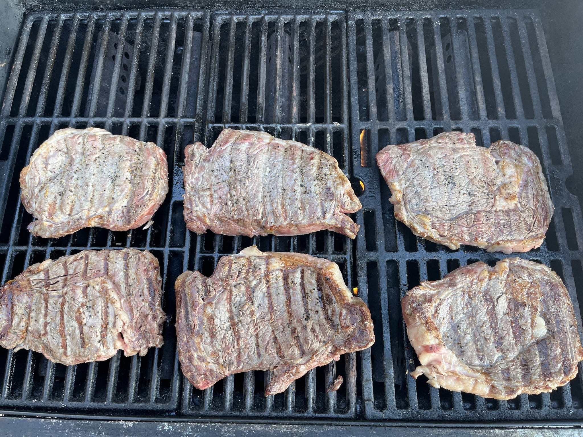
I was in North Carolina Christmas weekend in 2021, and it was really warm. I even barbecued the 26th, and have the pictures to prove it: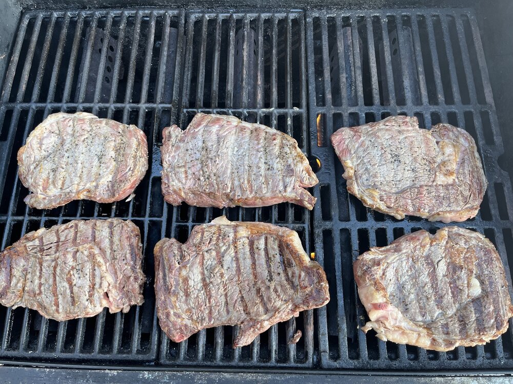
-
2025-2026 ENSO
PhiEaglesfan712 replied to 40/70 Benchmark's topic in Weather Forecasting and Discussion


-
2025-2026 ENSO
PhiEaglesfan712 replied to 40/70 Benchmark's topic in Weather Forecasting and Discussion
Oh please, no March 2001. I would not wish that on any snow lover. I'd prefer March 2017 as an analog. -
E PA/NJ/DE Winter 2025-26 Obs/Discussion
PhiEaglesfan712 replied to LVblizzard's topic in Philadelphia Region
Does this mean an early start to spring?