PhiEaglesfan712
-
Posts
1,686 -
Joined
-
Last visited
Content Type
Profiles
Blogs
Forums
American Weather
Media Demo
Store
Gallery
Everything posted by PhiEaglesfan712
-
E PA/NJ/DE Spring 2026 Obs/Discussion
PhiEaglesfan712 replied to PhiEaglesfan712's topic in Philadelphia Region
It's been like this since about March 8, a coast-to-coast torch. -
2026-2027 Super El Nino
PhiEaglesfan712 replied to Stormchaserchuck1's topic in Weather Forecasting and Discussion
The only time we got wet was the Nor'easter in the closing days of April, which brought a lot of rain the weekend of the 28th-30th. Other than that, late winter and spring 2023 was dry, with May being the driest on record. Late June and early July is when it got wet. -
E PA/NJ/DE Spring 2026 Obs/Discussion
PhiEaglesfan712 replied to PhiEaglesfan712's topic in Philadelphia Region

-
E PA/NJ/DE Spring 2026 Obs/Discussion
PhiEaglesfan712 replied to PhiEaglesfan712's topic in Philadelphia Region
Something weird is going on. I haven't seen this many temperature swings like this year. 20 degrees is normal, but there have been many 30, 40, and even one 50-degree swing so far. That isn't normal. I really hope this doesn't continue into the summer. I don't want it to be 100 degrees one day, and then 60 the next, in June or July. If I wanted this type of weather, I would move to Nebraska. -
E PA/NJ/DE Spring 2026 Obs/Discussion
PhiEaglesfan712 replied to PhiEaglesfan712's topic in Philadelphia Region
Where? Vermont? NH? Maine? Because there isn't any snow happening anywhere near here. -
All these torches since early March have hit, though.
- 970 replies
-
- 3
-

-

-

-
- april showers bring may..
- rain
- (and 2 more)
-
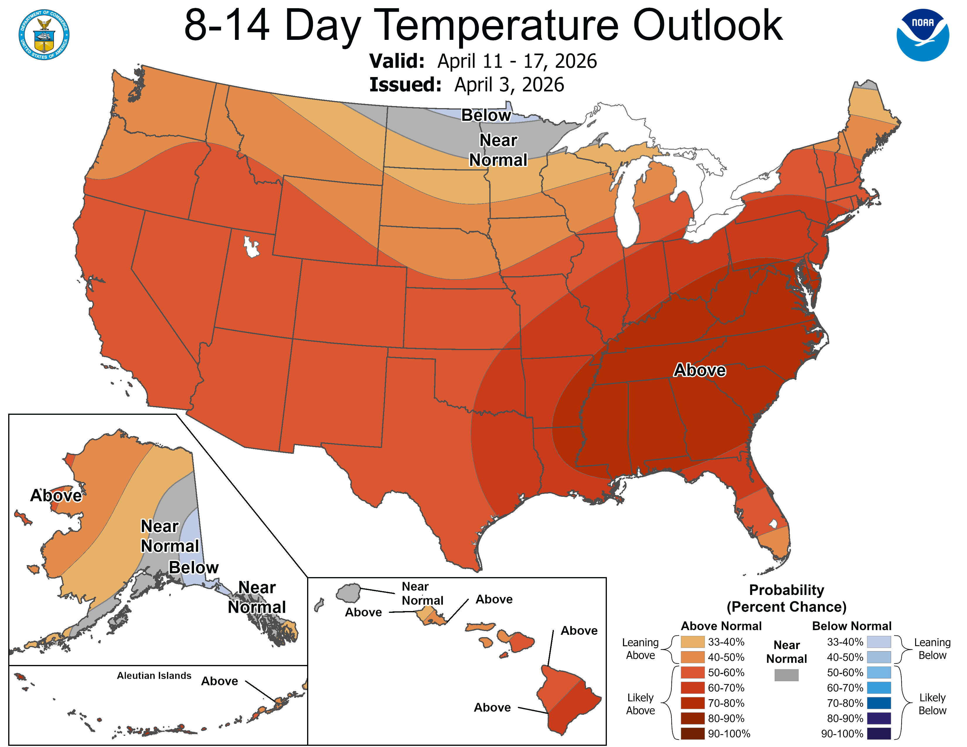
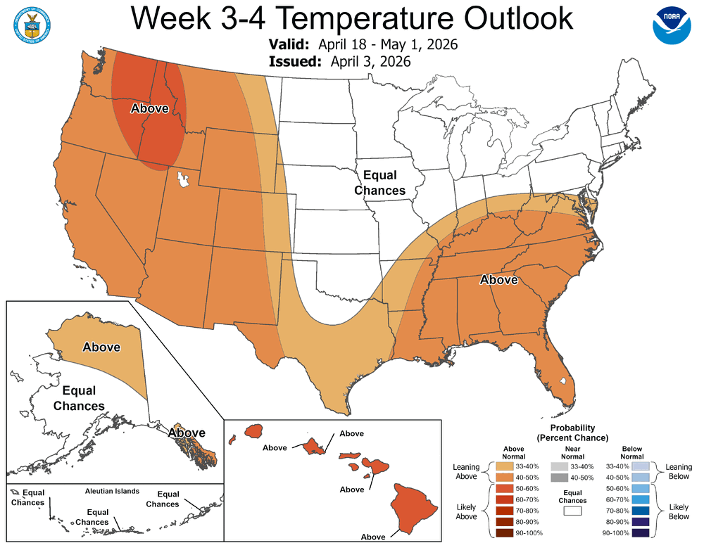
The last time they changed location was late 1930s/early 1940s, I think. Before that, it was in Center City. The EURO shows sustained warmth coast-to-coast (see @bluewave's post in page 2). We've been in that pattern since early March.
-
If that happens, and the heat dome is centered somewhere around Death Valley, the American/global temperature record of 134 degrees could finally fall.
-
There hasn't been plenty cold aloft since at least early March. I was in Vermont for 3 days (March 7-9), and it was 55+ each day. I knew winter was essentially over at that point. And that's okay, as sometimes, the coolest winters end abruptly. Look at 2010 (after February) and 2015 (after March), for example. 2010 had (at the time, it was broken only 2 years later) the warmest spring on record, and 2015 had a near record warm May. The Euro is also showing a torch pattern mid-month, coast-to-coast.
-
PHL was 84. RECORD EVENT REPORTNATIONAL WEATHER SERVICE MOUNT HOLLY NJ0530 PM EDT WED APR 01 2026...RECORD HIGH TEMPERATURE SET AT PHILADELPHIA PA...A RECORD HIGH TEMPERATURE OF 84 DEGREES WAS SET AT PHILADELPHIA PA TODAY. THIS BREAKS THE OLD RECORD OF 81 DEGREES SET, WHICH WAS FIRST SET IN 1917 AND TIED AGAIN IN 1978.TEMPERATURE RECORDS FOR THE PHILADELPHIA AREA DATE BACK TO DECEMBER OF 1873.
- 970 replies
-
- 2
-
-
- april showers bring may..
- rain
- (and 2 more)
-
2026-2027 Super El Nino
PhiEaglesfan712 replied to Stormchaserchuck1's topic in Weather Forecasting and Discussion
I wouldn't be too sure. After the 1997-98 event, a double-year strong la nina followed. -
In case you haven't gotten it by now, winter is over: https://x.com/epawawx/status/2038305484810092870
- 970 replies
-
- 1
-

-
- april showers bring may..
- rain
- (and 2 more)
-
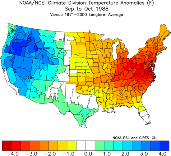
Then, there was a huge rainstorm the weekend after (which would have been a snowstorm if it happened earlier in the season). This does not look accurate. 2025 should be there, not 2023. Plus, some of those months, off memory, I can tell you should have negative temperature departures.
-
What in the Mid-Atlantic forum is this?
-
2026-2027 Super El Nino
PhiEaglesfan712 replied to Stormchaserchuck1's topic in Weather Forecasting and Discussion
Yeah, they prematurely overhyped the el nino. But by the time you got to 14-15, you just knew whenever the el nino developed, it was going to be historic. The el nino was building up for 3-4 years at that time. I'd even argue that 2024-25 was a la nina bust, as well. That one was predicted early on to be a strong la nina, but ended up as a disjointed 2-year la nina. -
A moderate el nino would be nice for a change. We haven't had a true one since 2002-03. Closest we had was 2006-07 (but that stalled at 0.9 on the ONI and RONI) and 2009-10 (but that went over 1.5). Moderate el ninos seem to be the sweet spot for good winters in the Eastern US. The only one that didn't really pan out was 1994-95, but that was due to a -PDO, and even then, we got one good month of winter weather (February).
-
March is going to be the first widespread AN temperature month for Eastern US cities since September. October and November were NN, and of course, December, January, and February were solidly BN.
-
2026-2027 Super El Nino
PhiEaglesfan712 replied to Stormchaserchuck1's topic in Weather Forecasting and Discussion
Come to think of it, 2015-16 is the only el nino post 2002-03 that is a +PDO. 2004-05 -PDO 2006-07 -PDO 2009-10 neutral PDO (November December -PDO; January February +PDO) 2015-16 +PDO 2018-19 -PDO 2023-24 -PDO -
2026-2027 Super El Nino
PhiEaglesfan712 replied to Stormchaserchuck1's topic in Weather Forecasting and Discussion
If the PDO turns positive this year, then 1988 becomes the obvious anti-2026 log. In the East, 1988 was a very warm summer, followed by a very cool fall.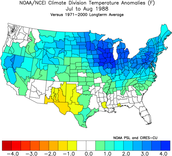
-
I mean, I called this back in early February. I just knew the cold pattern wasn't going to last forever. 3 solid BN temperature months is the most we can get at a time. The last time it happened was in January-March 2015. April 2015 is when things turned warmer, and May 2015 was a near record warm month. It looks like the same thing is happening.
-
March 7 weekend was a warm anomoly. I was in Manchester, Vermont from March 7-9 (Saturday-Monday), and it was 55+ each day. The only time I saw a frozen ground was going up to Weston on that Monday morning, before going back home.
-
I've been saying May 2015 is a good analog for April. Second month after the end of a cold and snowy winter, and a possible budding strong el nino.
-
How best to embed pictures?
PhiEaglesfan712 replied to VBweather's topic in Forum Information & Help
What this board needs to do is remove the attachment quota (like The Weather Forums does), or at least put it high enough that we don't have to remove our old attachments on a regular basis. -
The last 6 weekends (before this past one) were warm.
-
Not even just the last 2 minutes. 3:24 in the first half, Duke was up 44-25. They never score the rest of the half. If they score even 2 points in that 3:24, they would have won. It's the little things in the game, which may seem innocent at the time, that end up being the difference.