PhiEaglesfan712
-
Posts
1,684 -
Joined
-
Last visited
Content Type
Profiles
Blogs
Forums
American Weather
Media Demo
Store
Gallery
Everything posted by PhiEaglesfan712
-
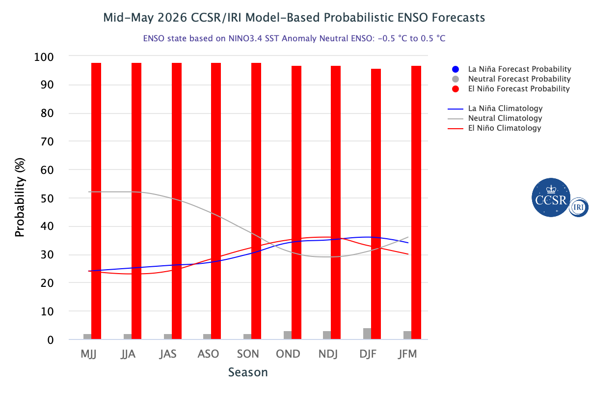
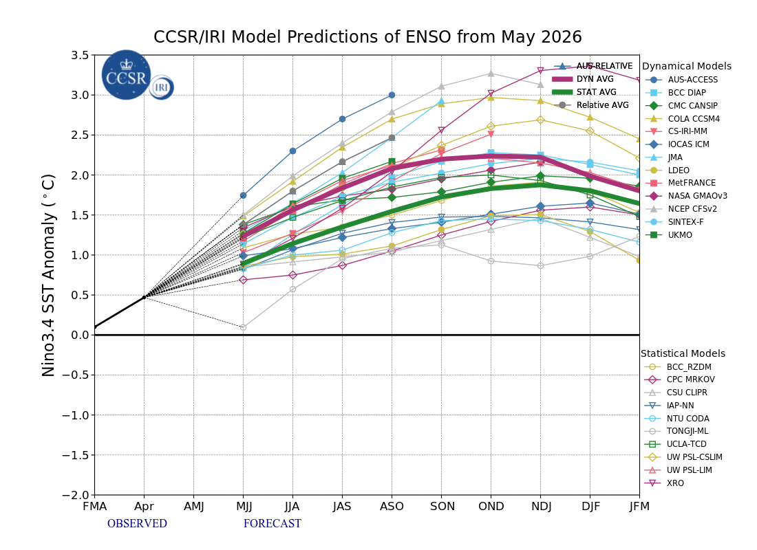
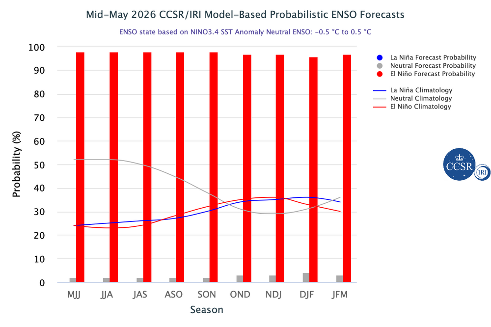
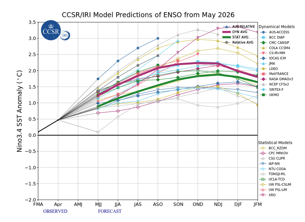
2026-2027 Super El Nino
PhiEaglesfan712 replied to Stormchaserchuck1's topic in Weather Forecasting and Discussion
Global temperatures will jump, unless we get an eruption of Mt. Rainier (and really soon). Remember, Pinatubo erupted in mid-June of a developing strong el nino. Prevented a temperature jump from happening in 1992, and in fact temporarily caused a decrease in global temperatures. Also, led to one of the coldest summers on record CONUS in 1992, as well as contributed to the great winters of 1992-93, 1993-94, and 1995-96 in the Eastern US. -
Idalia (in 2023) should have been retired as well. I guess there must be a shortage of I names that they need to keep them in there unless there is a truly historic storm.
-
E PA/NJ/DE Spring 2026 Obs/Discussion
PhiEaglesfan712 replied to PhiEaglesfan712's topic in Philadelphia Region
May average temperature finishes at 65.6 at PHL, which is 1.3 degrees above the 1991-2020 average (1.7 degrees above the 1981-2010 average). Meterological spring average temperature finishes at 57.8 at PHL, which is tied for the 3rd warmest spring on record (with 1921, and behind only 2010 and 2012). -
2026-2027 Super El Nino
PhiEaglesfan712 replied to Stormchaserchuck1's topic in Weather Forecasting and Discussion
What about a one-month relaxation like 1994-95 (which was a -PDO el nino)? November 1994-January 1995 were really warm and snowless, but there was a cold and snowy window in February 1995, before the warm and snowless weather returned in March. 94-95 ended up very warm and below average snowfall, but at least we got a respectable winter month out of it. -
The bipolar weather just doesn't seem to stop this year. It seems like this summer is going to have several 100-degree days, and several 55-degree days as well.
-
2026-2027 Super El Nino
PhiEaglesfan712 replied to Stormchaserchuck1's topic in Weather Forecasting and Discussion
New York Post posted an article about Mt. Rainier possibly erupting: https://nypost.com/2026/05/29/science/most-dangerous-us-volcano-mt-rainier-could-devastate-60000-residents/ This is probably the only thing that can prevent another temperature jump from this upcoming el nino. Remember that Pinatubo erupted in mid-June 1991, ahead of a robust el nino. -
2026-2027 Super El Nino
PhiEaglesfan712 replied to Stormchaserchuck1's topic in Weather Forecasting and Discussion
If you told me this upcoming el nino is going to be a modoki, I'll gladly take my chances with it. -
2026-2027 Super El Nino
PhiEaglesfan712 replied to Stormchaserchuck1's topic in Weather Forecasting and Discussion
Plus, a similar strength el nino in 09-10, which produced a very cold (and in the mid-Atlantic, very snowy winter) happened in between. In hindsight, though, we probably should have seen that 25-26 was going to be a cold and snowy winter in the East, and warm in the West. 25-26 was the 2nd year without a defined ENSO state. In recent times, 2nd years without a defined ENSO state (93-94 and 13-14) were cold and snowy in the East, and warm in the West. -
The easiest compromise is to meet halfway, and make it permanently 30 minutes ahead of standard time.
-
With Memorial Day in the rearview mirror, it's now time to start the summer thread. We have a developing strong/super el nino. Such summers are known for producing cooler than normal summers in the Eastern US. Such years include 1972, 1982, 1986, 1997, 2009, and 2023.
-
Can you expand these to 3 days (Saturday, Sunday, and Monday), so I can see the whole picture for the entire Memorial Day weekends? For example, 2021 at 72 and 0.00 rain looks misleading because you had highs in the 50s (probably record low maxes) and a lot of rain on Saturday and Sunday.
-
E PA/NJ/DE Spring 2026 Obs/Discussion
PhiEaglesfan712 replied to PhiEaglesfan712's topic in Philadelphia Region
You must either have the shortest memory ever or you are purposely trying to manipulate things. I love how you just disappear during a heatwave, when the weather doesn't support your agenda. I didn't see you post in early March when it was in the 80s, or in mid-April when it was in the 90s either. Anyways, you only have to go back 5 years to find a colder Memorial Day weekend (I remember this because I got my first COVID shot that Saturday, and man that was a very miserable weekend): 2021-05-29 54 48 51.0 -17.1 14 0 0.66 0.0 0 2021-05-30 53 47 50.0 -18.4 15 0 0.29 0.0 0 -
Yeah, the fact that no monthly record low was set in the post-Pinatubo years (1992-1996) makes me believe it's never going to happen again. Global temperatures have jumped so much in the last 30 years.
-
Big Temperature swings this spring 2026-03-10 83 40 61.5 19.9 3 0 0.00 0.0 0 2026-03-11 83 52 67.5 25.6 0 3 0.02 0.0 0 2026-03-12 69 35 52.0 9.8 13 0 0.16 T 0 2026-03-13 49 31 40.0 -2.5 25 0 0.00 0.0 0 2026-03-31 81 62 71.5 22.9 0 7 0.00 0.0 0 2026-04-01 84 58 71.0 22.0 0 6 0.47 0.0 0 2026-04-02 58 43 50.5 1.1 14 0 0.13 0.0 0 2026-04-03 71 44 57.5 7.7 7 0 T 0.0 0 2026-04-04 84 48 66.0 15.9 0 1 0.00 0.0 0 2026-04-05 73 48 60.5 10.0 4 0 0.41 0.0 0 2026-04-06 59 43 51.0 0.1 14 0 T 0.0 0 2026-04-07 56 38 47.0 -4.3 18 0 T 0.0 0 2026-04-08 55 31 43.0 -8.7 22 0 0.00 0.0 0 2026-04-15 91 62 76.5 22.1 0 12 T 0.0 0 2026-04-16 91 65 78.0 23.2 0 13 0.00 0.0 0 2026-04-17 83 67 75.0 19.8 0 10 0.00 0.0 0 2026-04-18 78 53 65.5 10.0 0 1 0.00 0.0 0 2026-04-19 57 44 50.5 -5.4 14 0 0.01 0.0 0 2026-04-20 55 40 47.5 -8.8 17 0 T 0.0 0 2026-04-21 58 34 46.0 -10.6 19 0 0.00 0.0 0 2026-05-18 96 65 80.5 15.7 0 16 0.00 0.0 0 2026-05-19 98 71 84.5 19.4 0 20 0.04 0.0 0 2026-05-20 95 69 82.0 16.6 0 17 0.21 0.0 0 Saturday's high projected to be only in the 50s.
-
2026-2027 Super El Nino
PhiEaglesfan712 replied to Stormchaserchuck1's topic in Weather Forecasting and Discussion
1982 wasn't W based. That one topped out at +4.6 on Nino 1+2, which is even higher than 1997 (4.1). If anything, 1982 should be E based. 82-83 peaks Nino 1+2: 4.6 Nino 3: 2.9 Nino 3.4: 2.9 Nino 4: 1.3 97-98 peaks Nino 1+2: 4.1 Nino 3: 3.3 Nino 3.4: 2.2 Nino 4: 1.1 -
Is that an all-time record high for the station?
-
Oh yeah, I almost forgot Providence's earliest 100-degree day was set last year (June 24). 98 was the previous record prior to 6/30 (set in the April 1976 heat wave).
-
2026-2027 Super El Nino
PhiEaglesfan712 replied to Stormchaserchuck1's topic in Weather Forecasting and Discussion
-
Yeah, 1976 was the year when the highest temp was hit in April, during the Easter heatwave, for many spots in New England, and as far south as Philly. Things turned cold very early that season, with October 1976-January 1977 being the coldest October-January on record. (The spring that followed was one of the warmest on record, despite a snow event on May 9-10.)
-
2026-2027 Super El Nino
PhiEaglesfan712 replied to Stormchaserchuck1's topic in Weather Forecasting and Discussion
Oddly enough, 1991 was a pre-nino May (although there would be the major volcano the following month that made sure the nino event behaved weirdly). -
E PA/NJ/DE Spring 2026 Obs/Discussion
PhiEaglesfan712 replied to PhiEaglesfan712's topic in Philadelphia Region
You'll be back to mid-50s weather by Saturday. It's been that type of spring. -
2026-2027 Super El Nino
PhiEaglesfan712 replied to Stormchaserchuck1's topic in Weather Forecasting and Discussion
09-10 showed that we can get a good winter out of a strong modoki el nino. We just need a good blocking pattern. -
I expected the temperature swings to be done by now. I haven't seen a spring as bipolar as this one (I wonder if it's due to there being a really cold winter and the ocean temps are cold), and I'm starting to worry it will bleed into summer. We've had 80 degree days followed by 30 degree ones, 90 degree days followed by 40 degree ones, and now 95 degree days followed by 50 degree ones.
-
I hope this isn't a preview of summer. I'm just tired of these wild temperature swings. I'd much rather have it be one consistent temperature, whether it be the 90s, 80s, or heck, even 70s. But I can't do it if we're going to have runs in the 100s this summer, only to be followed by temps in the 50s soon thereafter.
-
2026-2027 Super El Nino
PhiEaglesfan712 replied to Stormchaserchuck1's topic in Weather Forecasting and Discussion
Yeah, that 2018-20 period was a disjointed at best. We didn't really have a definitive ENSO or PDO state during those years (the PDO was near neutral for the greater part of almost 4 years after the mid-2010s el nino dissipated), until we got to 2020-21, which was a solid la nina and -PDO.