.jpg.b9a795a9fe89b3aa2ead015665ae36fe.jpg)
nvck
-
Posts
458 -
Joined
-
Last visited
Content Type
Profiles
Blogs
Forums
American Weather
Media Demo
Store
Gallery
Everything posted by nvck
-
just ripped snow here for about 3 minutes, hasn't dropped below 32 yet today, though.
-
Got this earlier as a cell crawled down from Clare. not a ton of lightning, but really crisp updrafts all around.
.thumb.jpg.142e0379be7558c789233b95a8908331.jpg)
-
barely hit 70 today, but plenty of showers/weak tstorms around. campus wx camera has a nice view: http://weather.eas.cmich.edu/current/webcam/2026-04-16-17-56.jpg
-
Also, thinking they may go MDT with the 1630z update
-
Beautiful light show last night here, went and sat out in a field for ~90 minutes, with constant lightning 20-40 miles away, first from the cell that moved through Saginaw, and then new stuff that back built from it, probably off of outflow?
-
What a time for the IWX radar to go down...
-
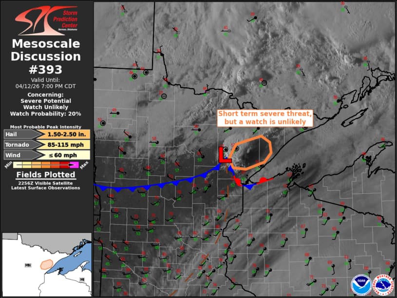
MD and then watch just issued pretty much back to back for IWX area
-
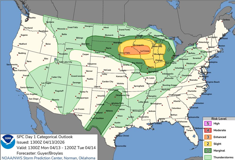
Surprised that the D2 update at 1730z didn't introduce any sort of ENH in Michigan
-
went ahead and started a thread
-
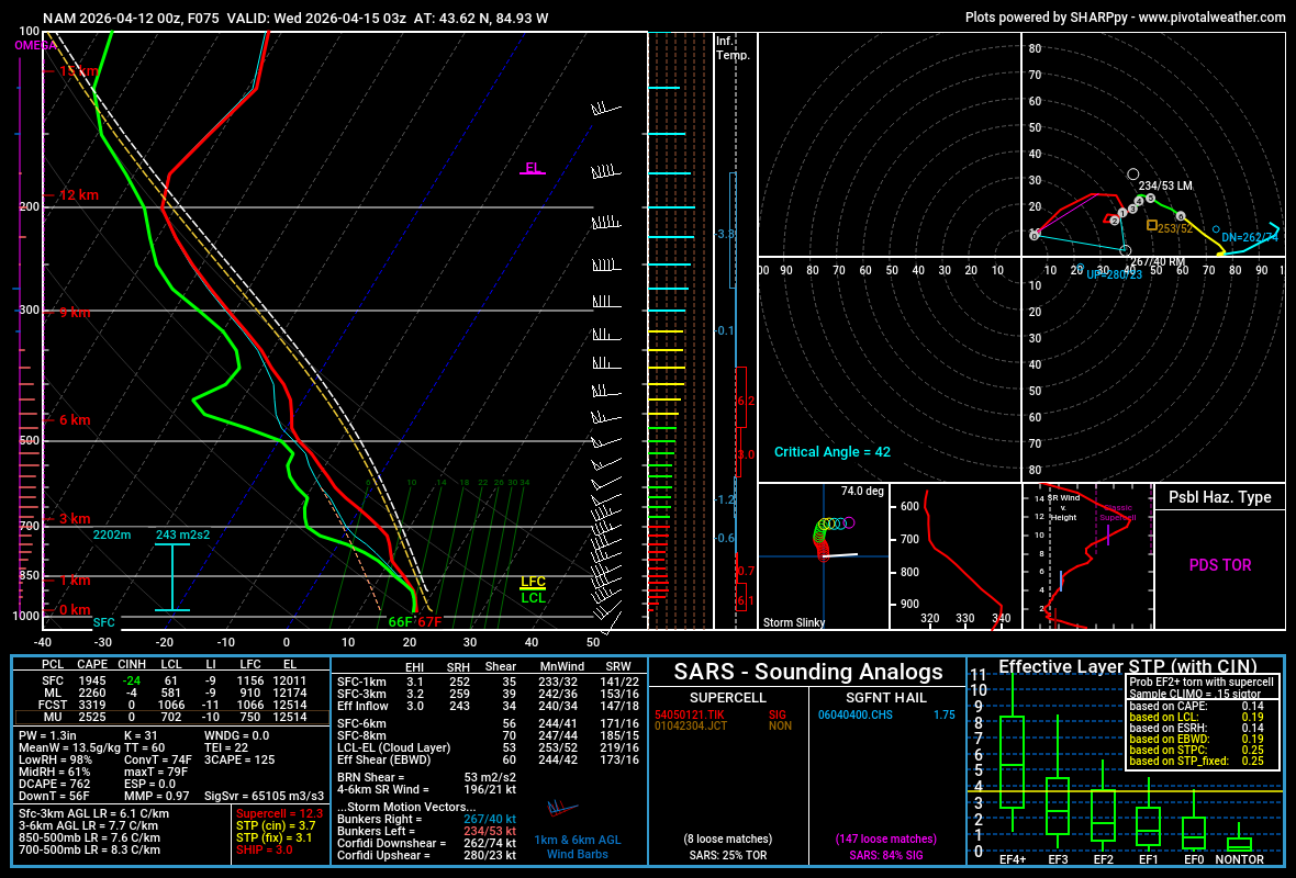
figured it's probably due, almost a lock that someone in the sub's gonna see some action today or tomorrow. primarily hail/tornado risk.
-
Single-cell MD up in your neck of the woods, @Brian D
-
warm front finally made it up here, about 45 minutes ago, 75/55 now, really feeling like we've got some good juice for storms
-
yeah, kinda concerned about flooding potential in the area this week, especially as soils are pretty saturated already
-
Yeah, sure
-
absolute peak weather here today, with what will probably be the last fully sunny day for a while.
-
tis the season

-
555 NOUS43 KDTX 052346 PNSDTX MIZ047>049-053>055-060>063-068>070-075-076-082-083-061200- Public Information Statement National Weather Service Detroit/Pontiac MI 746 PM EDT Sun Apr 5 2026 ...NWS Damage Survey for 04/04/2026 Tornado Event... .Van Buren Township Tornado... Rating: EF-1 Estimated Peak Wind: 100 mph Path Length /statute/: 3.25 miles Path Width /maximum/: 200 yards Fatalities: 0 Injuries: 0 Start Date: April 4, 2026 Start Time: 5:46 PM EDT Start Location: 2 NE Willis / Wayne County / MI Start Lat/Lon: 42.1788 / -83.5371 End Date: April 4, 2026 End Time: 5:50 PM EDT End Location: Belleville / Wayne County / MI End Lat/Lon: 42.2009 / -83.4749 The tornado started just south of Martz Rd between Rawsonville Rd and Hoeft Rd. It first flipped a hayride trailer and continued northeast toward Hull Rd. EF-1 damage occurred along Hull Rd with the greatest concentration of EF-1 damage along and just south of Hull Rd between Elwell Rd and Bak Rd. This damage included multiple trees uprooted and snapped, telephone poles snapped, and a large barn wall blown out. The tornado continued northeast crossing Sumpter Rd producing EF-0 damage with scattered large tree limbs and power lines downed. The tornado lifted right before reaching Savage Rd. && EF Scale: The Enhanced Fujita Scale classifies tornadoes into the following categories: EF0.....65 to 85 mph EF1.....86 to 110 mph EF2.....111 to 135 mph EF3.....136 to 165 mph EF4.....166 to 200 mph EF5.....>200 mph NOTE: The information in this statement is preliminary and subject to change pending final review of the event and publication in NWS Storm Data. $$ DTX confirmed an EF1 yesterday near Belleville, kinda surprised I didn't see more (any) talk about those spin-ups on here yesterday
-
approaching 3/4 of an " at the campus wx station, enough to cause some minor ponding in the fields
-
boring answer would be "frequency illusion", fun answer is that the US and (russia/china/iran) are knocking each other's military satellites out of orbit
-
up to 71 here, sunny, with a nice breeze. really the type of day you could just spend entirely outside and not complain
-
seems like it verified fairly well
-
sunday could have a legit hailer threat for a lot of the OV, 2k+ cape on the NAM & pretty steep lapse rates (7-8C/km)
-
haha, i bet. i'd like to experience it at least once in life. also crazy that he's seen an order of magnitude more snow this season than me, in the same state.
-
just insane, thanks for sharing. i don't think i can even imagine having so much snow on the ground, for such a long period of time.
-
76mph gust at KDAY
.thumb.jpg.ad3a2e31d30aff035044689b311a0540.jpg)
.jpg.2bb15fd602eeb4905069c18c634f958d.jpg)