.jpg.b9a795a9fe89b3aa2ead015665ae36fe.jpg)
nvck
-
Posts
445 -
Joined
-
Last visited
Content Type
Profiles
Blogs
Forums
American Weather
Media Demo
Store
Gallery
Everything posted by nvck
-
https://arstechnica.com/science/2025/12/trump-admin-threatens-to-break-up-major-climate-research-center/ Ik people stay away from politics here, but this would be awful if it happened. even if nothing happens (it probably won't), I hate that our field is politicized needlessly, and this really undermines the stability of the work they do at ncar
-
hitting 54 today has dissolved whatever snowpack remained from Saturday. Was nice while it lasted, but will take a couple weeks of warmth before (hopefully) a return to the cold
-
.thumb.jpg.ad3a2e31d30aff035044689b311a0540.jpg)
Winter 2025-26 Medium/Long Range Discussion
nvck replied to michsnowfreak's topic in Lakes/Ohio Valley
https://x.com/i/status/2001009884540834205 Fwiw (not much, probably) -
thinking that somewhere in the middletown to wilmington to circleville area is gonna cash w/ 7-8", just have gotta get lucky with the these bands of higher rates.
-
Really coming down here now, starting to accumulate on grass/vegetation, not much on the roads yet though. Temp is just below 32f, so hopefully it starts dropping soon and we see some higher ratio stuff move in
-
bengals tickets for a game w/ low teens air temp and sd's wind chill are going for about $20 on the upper bowl, lower for 40-50. Will probably be there, thats almost too good to pass up.
-
Wow that clipper today trended real far south and real weak, local mets have been scrambling to drop totals, the ones who had 3-5 for the Cincy metro really caught out, looks like most will be lucky to see 2.
-
We closed twice last year for cold, but never had enough snow to close for that
-
University delayed start until 11am, doesn't really seem like 4" would warrant that, but I guess so
-
Started coming down here around a half hour ago, hoping for a good 4-5 inches
-
crazy what a difference a few dozen miles makes
-
Winter 2025-26 Medium/Long Range Discussion
nvck replied to michsnowfreak's topic in Lakes/Ohio Valley
looks like 4-6" probable here by tomorrow afternoon, the hrrr finally got with the program and came way south. -
1 here right now, still looking for our 1st below 0 low. got about 15 minutes to get it, until the sun is really up.
-
Winter 2025-26 Short Range Discussion
nvck replied to SchaumburgStormer's topic in Lakes/Ohio Valley
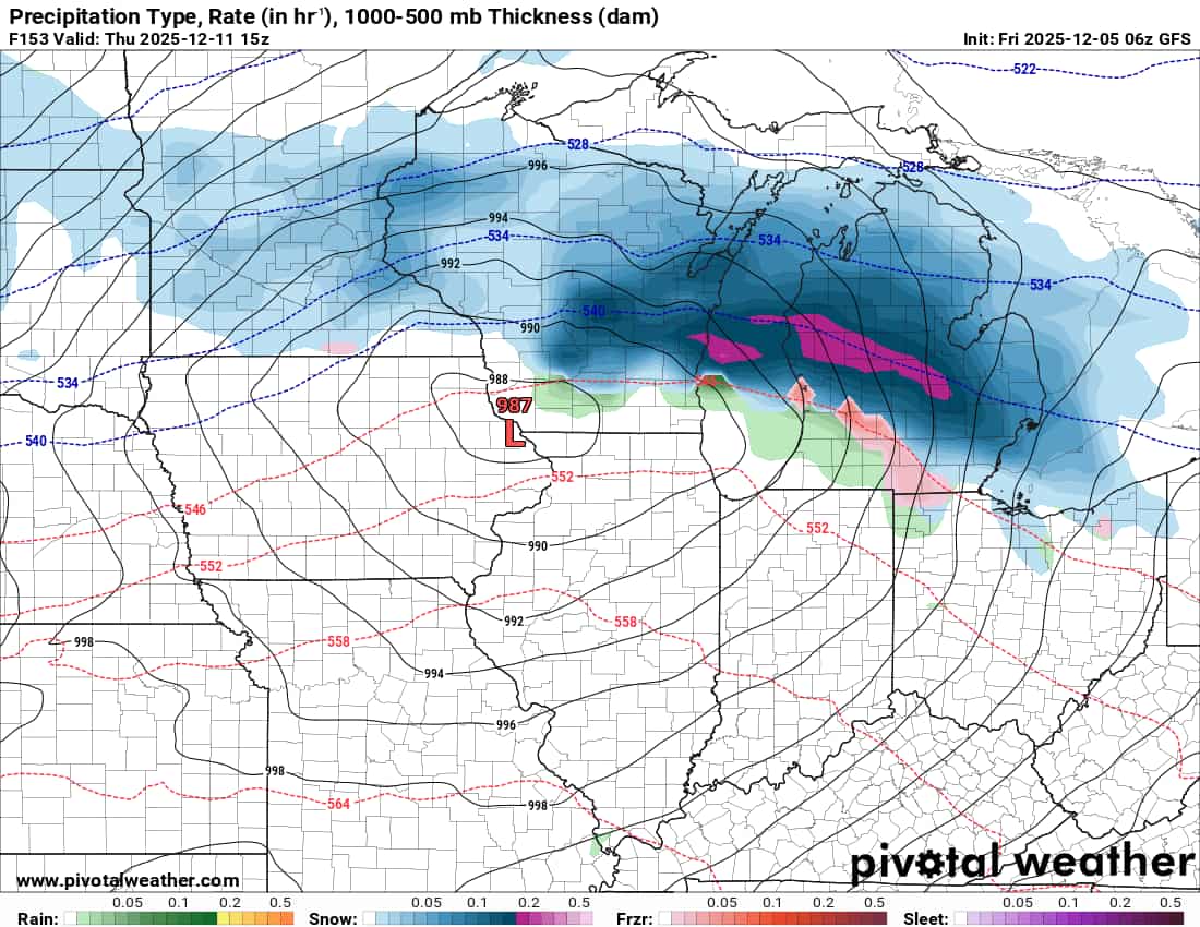
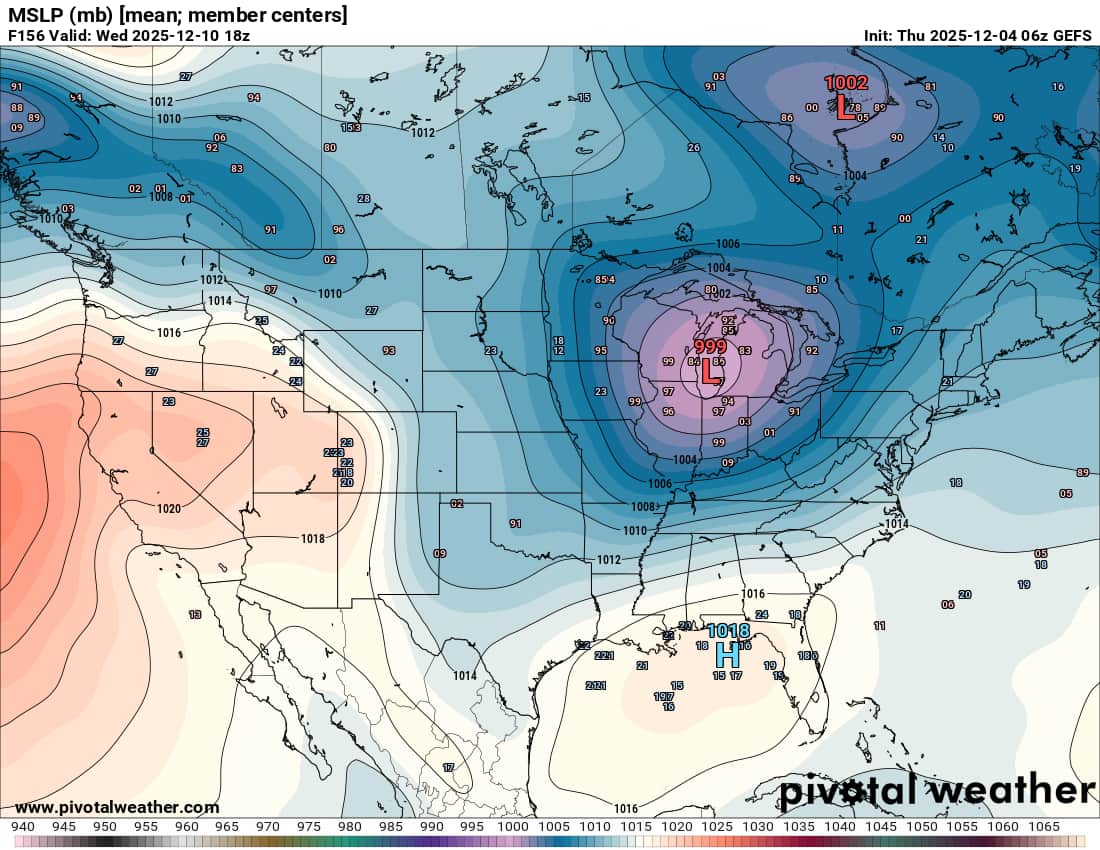
6z HRRR way, way north with the Wednesday system, and about 10mb deeper, faster than any other model -
Winter 2025-26 Medium/Long Range Discussion
nvck replied to michsnowfreak's topic in Lakes/Ohio Valley
#lockingitin (its 15mb weaker and a fifth of the snow on the new runs) -
Winter 2025-26 Medium/Long Range Discussion
nvck replied to michsnowfreak's topic in Lakes/Ohio Valley
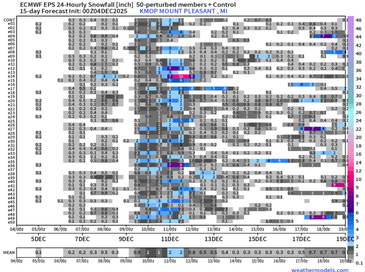
all-time weenie run for Mid-Michigan on the 6z gfs...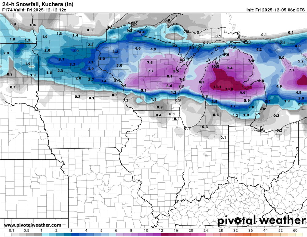

-
fire up!! yeah fair, i know a lot of people who are doing a minor or double major with met and gis
-
only got down to 14 here, but winds stayed between 6-10mph all night. yesterday's freezing rain/drizzle event left a nice coating of ice on the roads and sidewalks, and the snow now has a nice crust of ice on it as well.
-
haha you should've been here last January, we had almost a foot in a 24hr span.
-
Winter 2025-26 Medium/Long Range Discussion
nvck replied to michsnowfreak's topic in Lakes/Ohio Valley
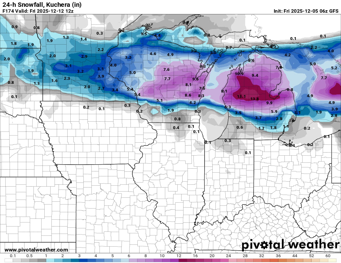
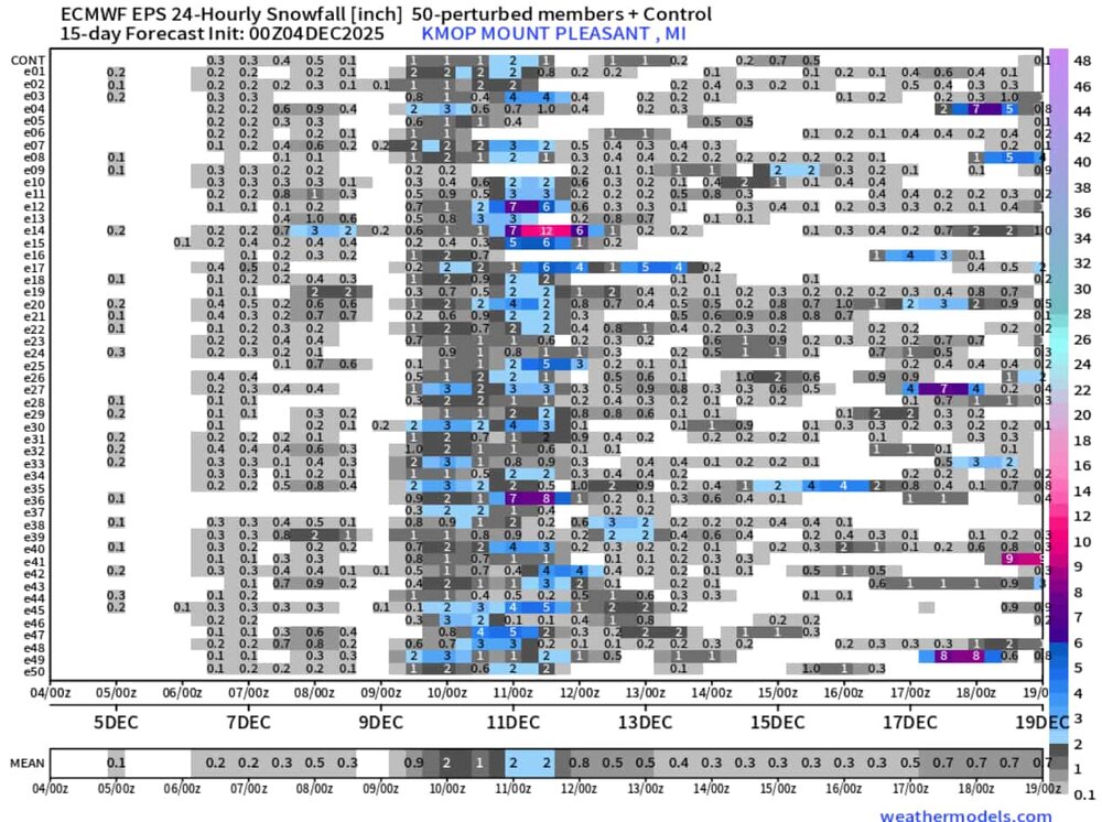
Eyeing next tuesday-wednesday-thursday for the next possible system of note around here. GRR mentions a lot of uncertainty, but the west ridge being a little more amplified should allow for a sw or two to ride the ridge down to the GL area and maybe bring a couple inches of snow. Would be a nice send-off from Michigan EPS 24hr snowfall very cluttered in that timespan but that 2nd system, late on the 10th-11th, has been uptrending a little bit the past few runs.
-
anyone know why NWS cleveland is issuing AFDs and other products for WIlmington? Been going on since Friday afternoon. staffing issue?
-
Winter 2025-26 Medium/Long Range Discussion
nvck replied to michsnowfreak's topic in Lakes/Ohio Valley
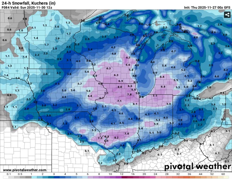
should be a nice early-season event for parts of IN and OH that missed out on the past weekend's big one.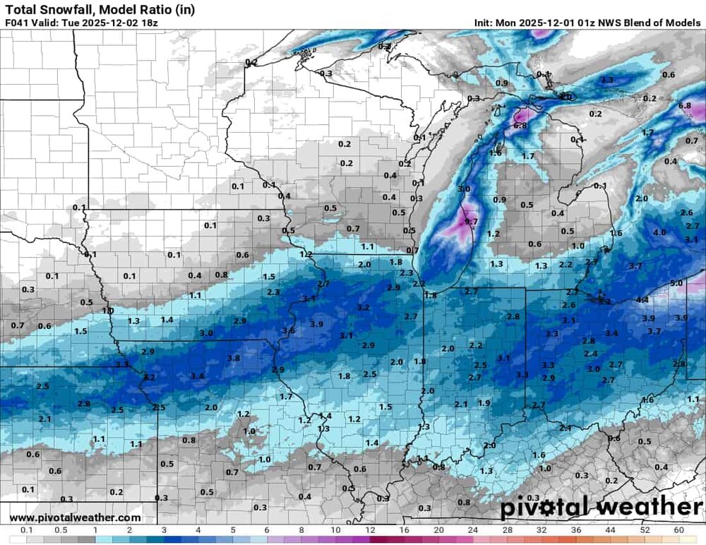
-
temp never really got below 34 here last night for any of the flurries to stick, then a changeover to rain stopped any hopes of accumulations. Still, really fun storm to track and I wasn't really expecting much down here anyways.
-
Looking less likely we'll get much of anything down here in s Ohio, although the GFS and nam are stubbornly holding onto a couple inches before some rain. Looking forward to seeing 6-8 on the ground headed back north, tho.
-
slightly lower totals across the board, vs the 18z