.jpg.b9a795a9fe89b3aa2ead015665ae36fe.jpg)
nvck
-
Posts
458 -
Joined
-
Last visited
Content Type
Profiles
Blogs
Forums
American Weather
Media Demo
Store
Gallery
Everything posted by nvck
-
1 here right now, still looking for our 1st below 0 low. got about 15 minutes to get it, until the sun is really up.
-
.thumb.jpg.ad3a2e31d30aff035044689b311a0540.jpg)
Winter 2025-26 Short Range Discussion
nvck replied to SchaumburgStormer's topic in Lakes/Ohio Valley
6z HRRR way, way north with the Wednesday system, and about 10mb deeper, faster than any other model -
Winter 2025-26 Medium/Long Range Discussion
nvck replied to michsnowfreak's topic in Lakes/Ohio Valley
#lockingitin (its 15mb weaker and a fifth of the snow on the new runs) -
Winter 2025-26 Medium/Long Range Discussion
nvck replied to michsnowfreak's topic in Lakes/Ohio Valley
all-time weenie run for Mid-Michigan on the 6z gfs...

-
fire up!! yeah fair, i know a lot of people who are doing a minor or double major with met and gis
-
only got down to 14 here, but winds stayed between 6-10mph all night. yesterday's freezing rain/drizzle event left a nice coating of ice on the roads and sidewalks, and the snow now has a nice crust of ice on it as well.
-
haha you should've been here last January, we had almost a foot in a 24hr span.
-
Winter 2025-26 Medium/Long Range Discussion
nvck replied to michsnowfreak's topic in Lakes/Ohio Valley
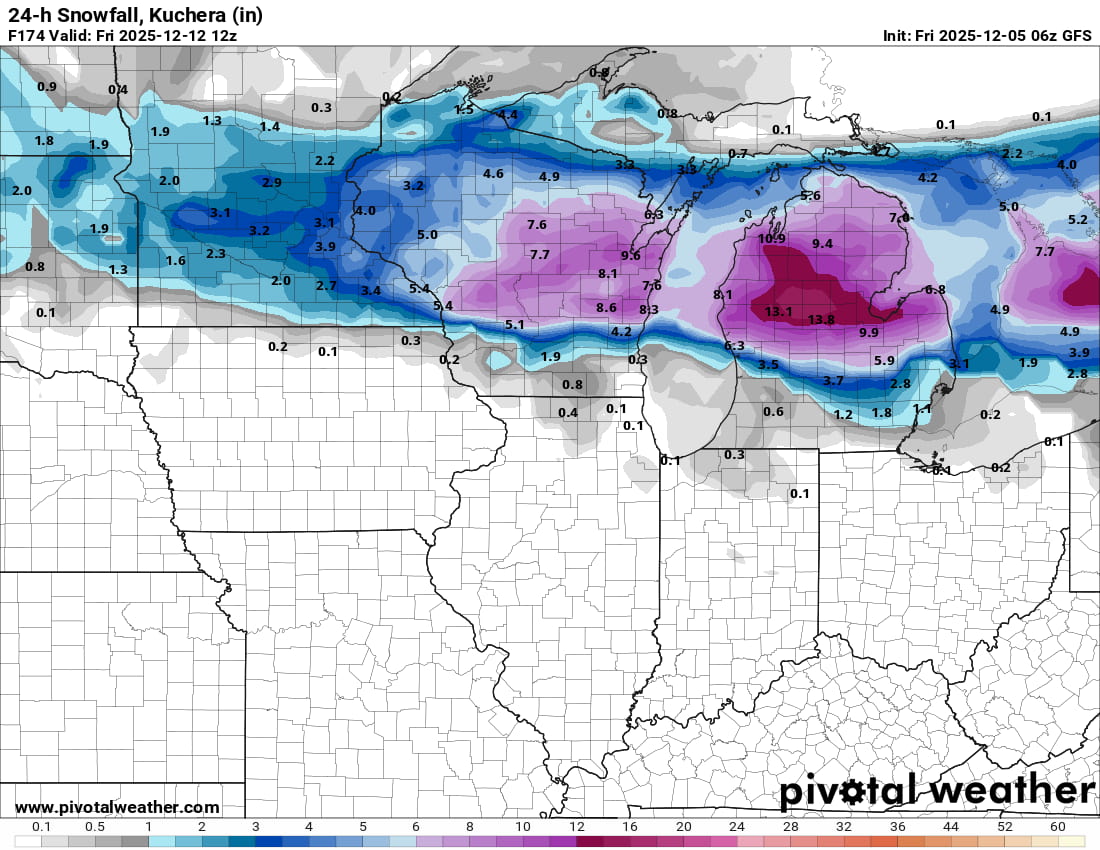
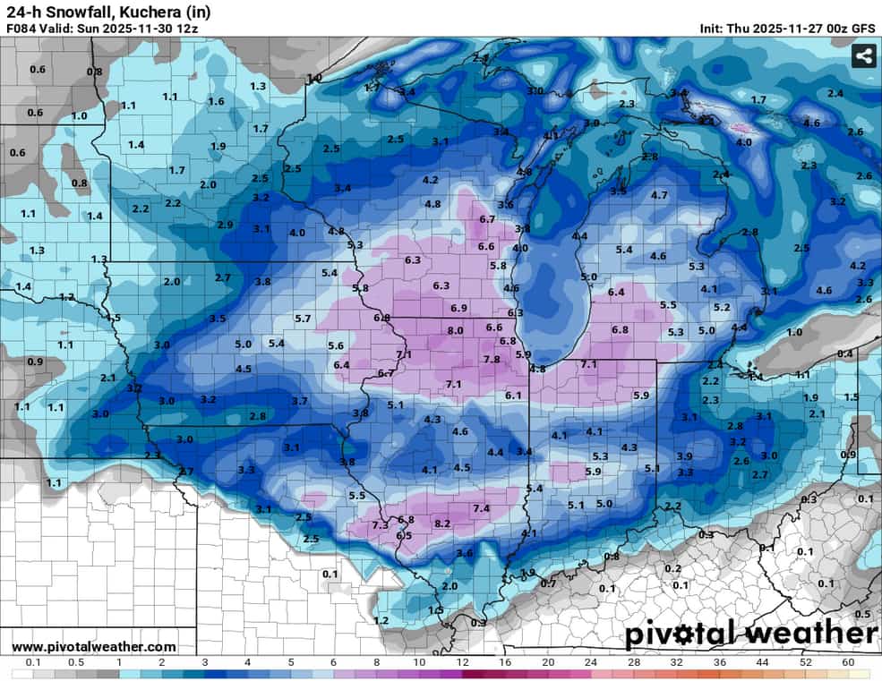
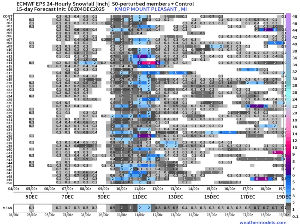
Eyeing next tuesday-wednesday-thursday for the next possible system of note around here. GRR mentions a lot of uncertainty, but the west ridge being a little more amplified should allow for a sw or two to ride the ridge down to the GL area and maybe bring a couple inches of snow. Would be a nice send-off from Michigan EPS 24hr snowfall very cluttered in that timespan but that 2nd system, late on the 10th-11th, has been uptrending a little bit the past few runs.
-
anyone know why NWS cleveland is issuing AFDs and other products for WIlmington? Been going on since Friday afternoon. staffing issue?
-
Winter 2025-26 Medium/Long Range Discussion
nvck replied to michsnowfreak's topic in Lakes/Ohio Valley
should be a nice early-season event for parts of IN and OH that missed out on the past weekend's big one.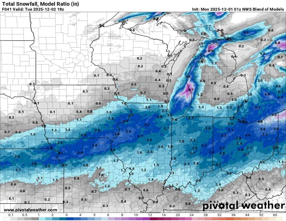
-
temp never really got below 34 here last night for any of the flurries to stick, then a changeover to rain stopped any hopes of accumulations. Still, really fun storm to track and I wasn't really expecting much down here anyways.
-
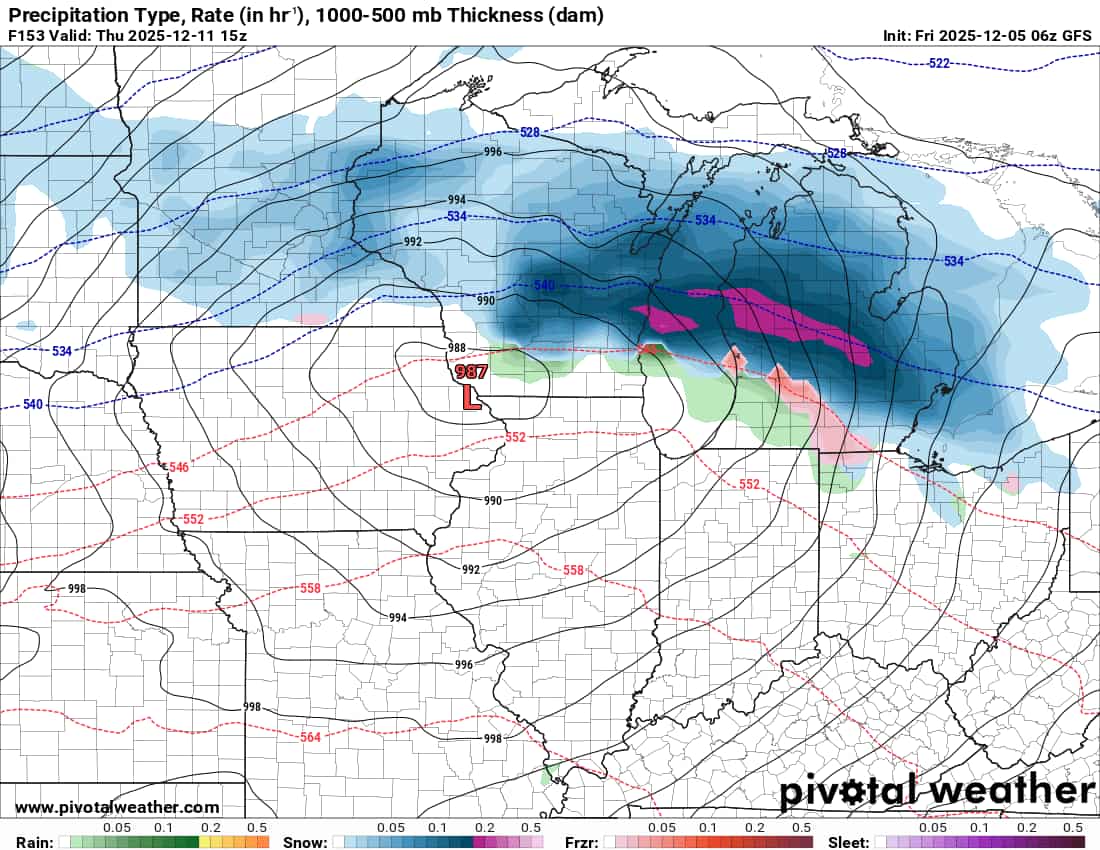
Looking less likely we'll get much of anything down here in s Ohio, although the GFS and nam are stubbornly holding onto a couple inches before some rain. Looking forward to seeing 6-8 on the ground headed back north, tho.
-
slightly lower totals across the board, vs the 18z

-
new gfs maybe seems slightly south w/ the surface low?
-
Scaled(54_).jpg.89693a39565f61e118f95ed43d33728e.jpg)
-
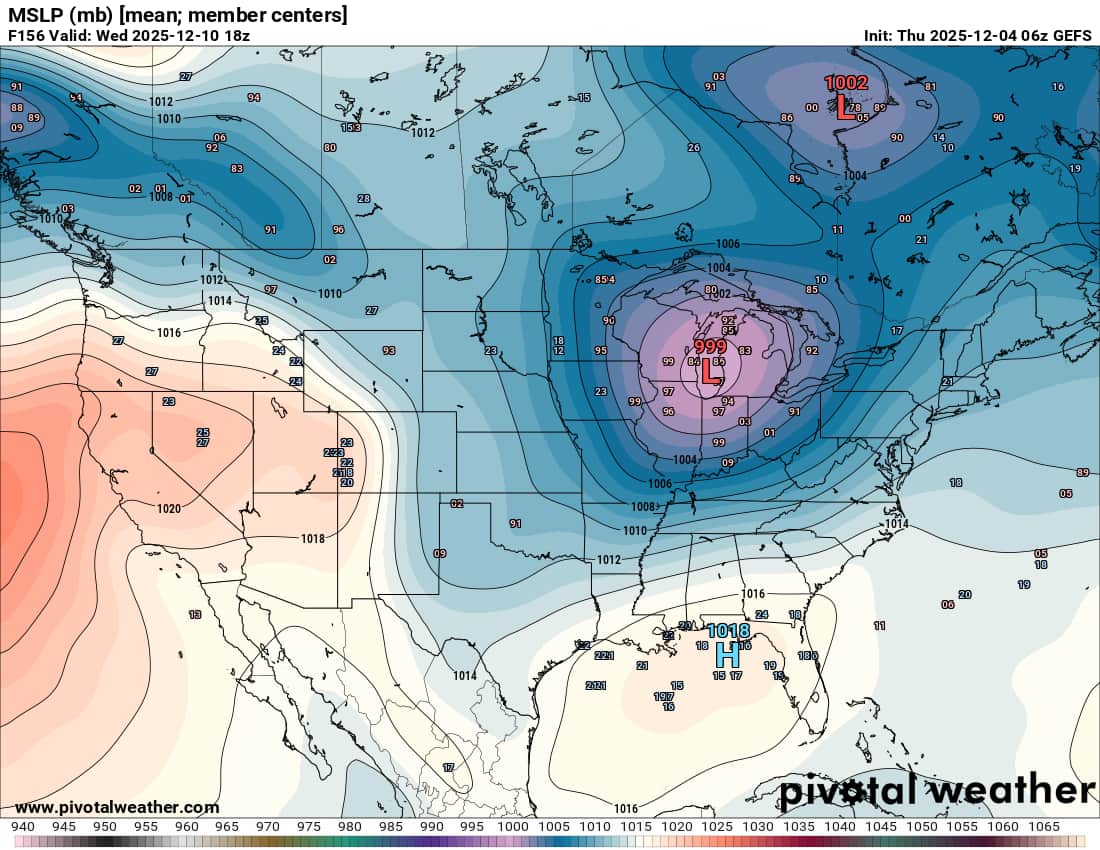
There is a reduction from the 12z, but relative to the 6z and 0z, looks fairly similar
.gif.a0e43d02452a32850913d70e1fd54304.gif)
-
we can't have our cake and eat it too...
-
If snow really makes it to Cincinnati on Saturday .... I'd be shocked to say the least lol
-
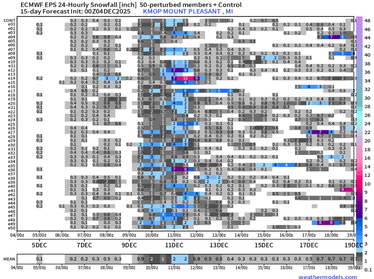
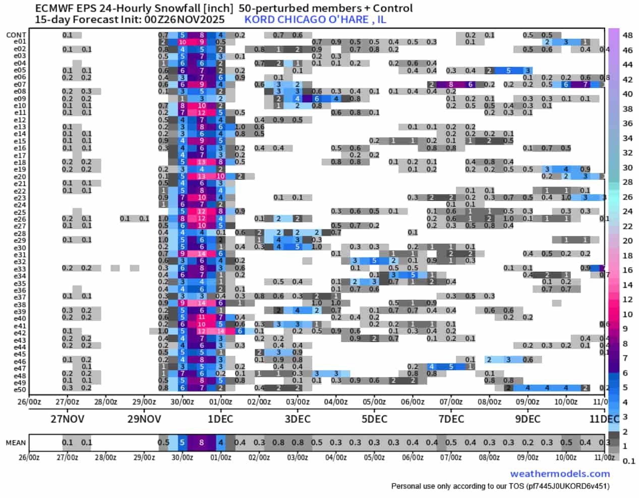
24hour snow at o'hare from the 00z eps. Trended up vs the prior day's 00z and 12z runs, no members w/ less than 3" now.

-
35mph gusts at like 4:30 woke me up this am, lots of stressed people on campus (we still have class today) who have to drive either north or to the west side of the state
-
18z euro has a slightly stronger low, and a rain/snow line similar (slightly north) to the 12z. still sketchy if ur a chicago poster
-
nothing but the best over there
-
think they might need to curve that arrow preeeeeeetty sharply in the opposite direction
-
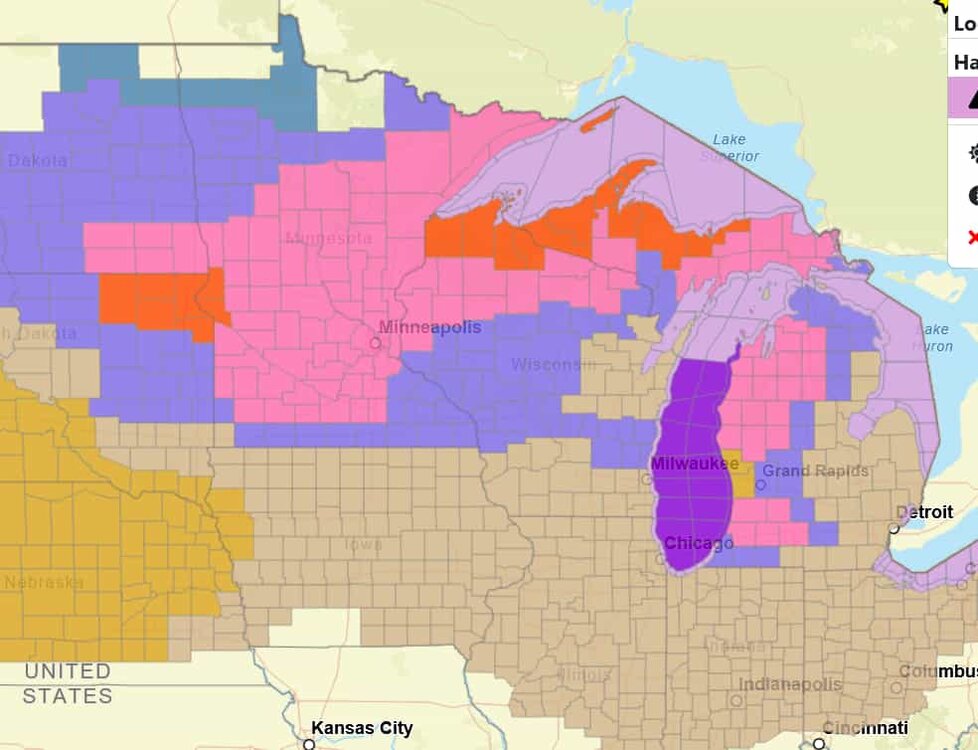
Good to see some colors back on the map
-
waiting on the euro in a couple hours, but between this run and the icon, its a good trend imo. keeps the rain/snow line south of i-94 in mi