.jpg.b9a795a9fe89b3aa2ead015665ae36fe.jpg)
nvck
-
Posts
462 -
Joined
-
Last visited
Content Type
Profiles
Blogs
Forums
American Weather
Media Demo
Store
Gallery
Everything posted by nvck
-
Heavy rain and some rumbles of thunder this morning, but it's been clearing out over the past hour or so, up to 81/72 at CVG. interested in what this line coming from our west will bring
-
crazy how perspectives on heat vary so much / change so quickly. coming out of the winter, first 70 degree day of the spring is usually pretty jarring, feels *hot* in the direct sun. after a few months of that, though, the 82 degree high here today felt super pleasant, even in direct sun
-
Last 2 runs of the nam are interesting around here for Saturday afternoon/evening
-
95% live w/in a county or two of 94 from Minneapolis to Detroit, it seems lol
-
https://x.com/i/status/2079366233460281713
-
Never seen anything like what's going on in Wisconsin rn
-
Rare to see the CSU and SPC so at odds (wrt Tuesday). 12k NAM has a couple rounds here locally, one midday and one later in the evening, while the RRFS has just one, in the afternoon. my interest is certainly piqued whenever we get strong flow in the summer, so expecting at least a few SVRs throughout the day.
-
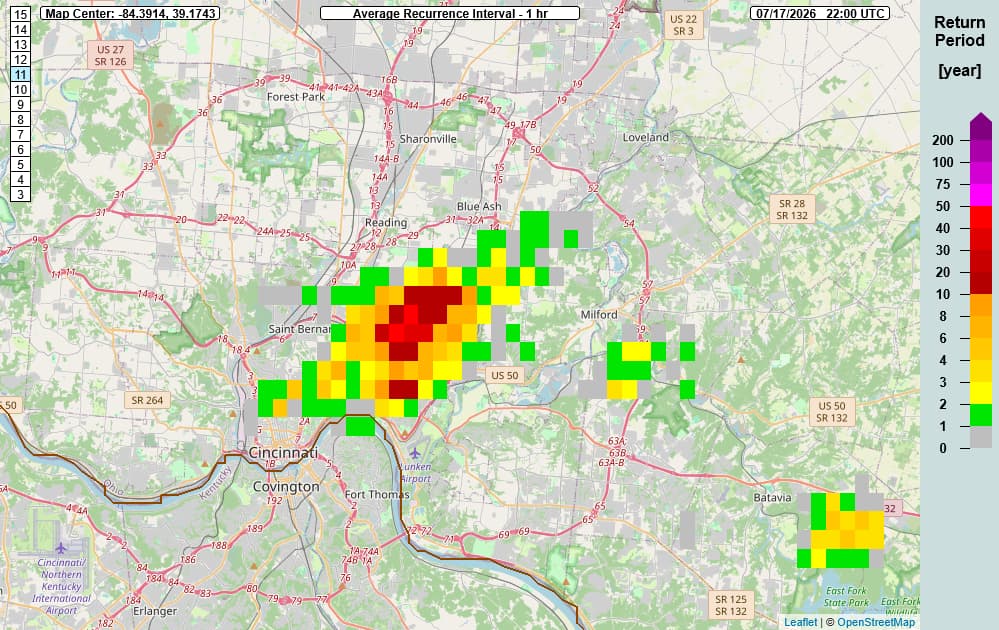
sig flash flooding here yesterday, 1-in-49 year return period. more prefrontals this afternoon before a shot at something more substantial tn
-
looks like we'll get lucky enough to avoid most of it in the cincy metro, aqi around 110 here. just north in middletown, dayton, columbus, seeing readings in the 500-600 range, though.
-
New hrrr has the whole LP engulfed in smoke by tonight, and most of Ohio by tomorrow morning.
-
Mt Pleasant at 100, Oscoda County at 104, models definitely had a good handle on the placement of the hottest temps being northeast central MI
-
90/69 at the cmu wx station now, maybe signs of dews starting to mix lower? Ticked down over the last half hour, need to see that pick up for a run at 100
-
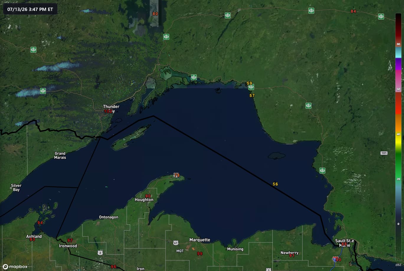
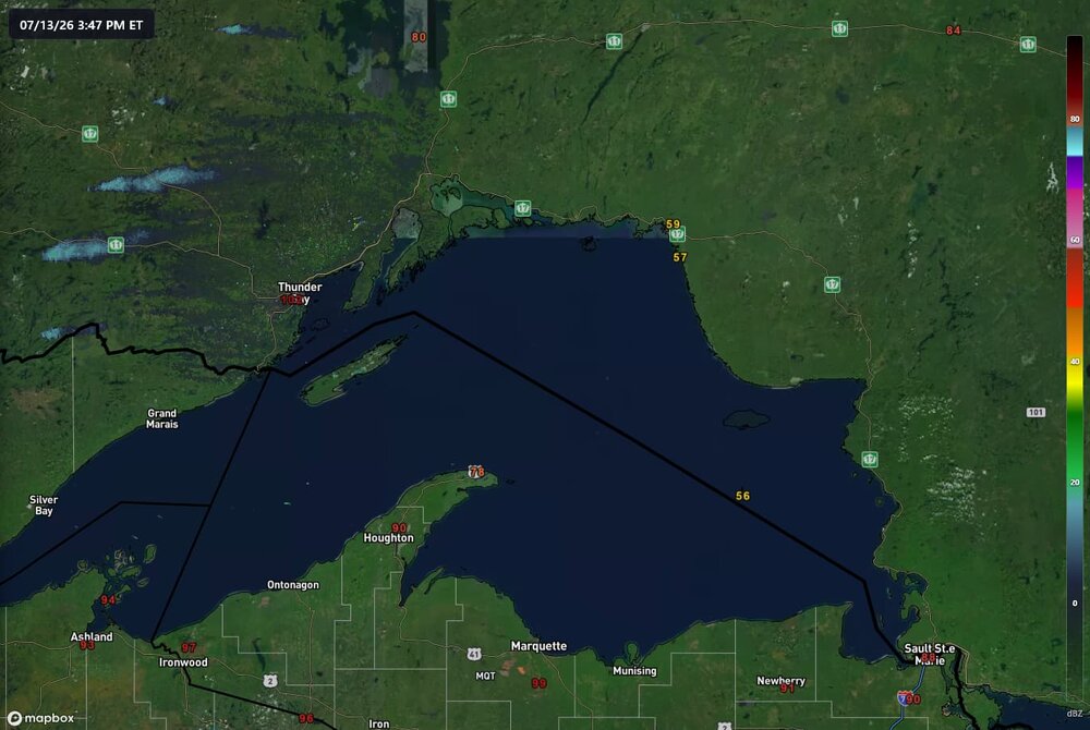
102 in thunder bay, 59 across the lake... nature's AC
-
this video is from vietnam, but there was, incredibly, another strong tornado in china a few days ago https://www.bbc.com/news/videos/cq61d22ved2o
-
81/78/89 at 8:30am... No thanks
-
90/80 imby is tough, air is just so thick. station might be running a bit warm/moist, but another PWS a couple blocks away is showing 93/81.
-
don't really buy the slight risk being pushed into Ohio tomorrow, ample shear but MLCAPE will likely be below 300j/kg. like wednesday's event on a budget.
-
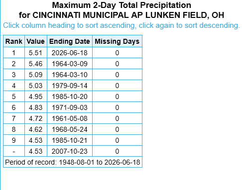
just had the wettest 2-day stretch on record at the municipal airport here, and those 5.51" came in a ~18 hour span.
-
oh for sure, the imagery from TCVG was insane nonetheless with that storm that went through florence
-
risk definitely verified around here
-
i think that southern one will stay south of 275, but the northern one could potentially impact the metro
-
even with the consistent stratiform stuff here, thinking it could be a busy next few hours, given whats unfolded to my west
-
80/70 probs on the new watch
-
HRRR over-mixing bias on display once again, latest run undershoots dew points by several degrees across my area, with obs in the colored labels. 13z RRFS seems to have a much better handle on moisture, although it's under-doing SBCAPE by 750-1000J/kg, per mesoanalysis
-
he's had some wins in the past, but this is definitely not one of them
.thumb.jpg.ad3a2e31d30aff035044689b311a0540.jpg)