SnoSki14
-
Posts
16,208 -
Joined
-
Last visited
Content Type
Profiles
Blogs
Forums
American Weather
Media Demo
Store
Gallery
Everything posted by SnoSki14
-
Snowstorm? I got a little more than inch that's gone already. I think most saw an advisory event at best. Even the worst winters usually deliver something. Good news is this miserable winter is just about over
-
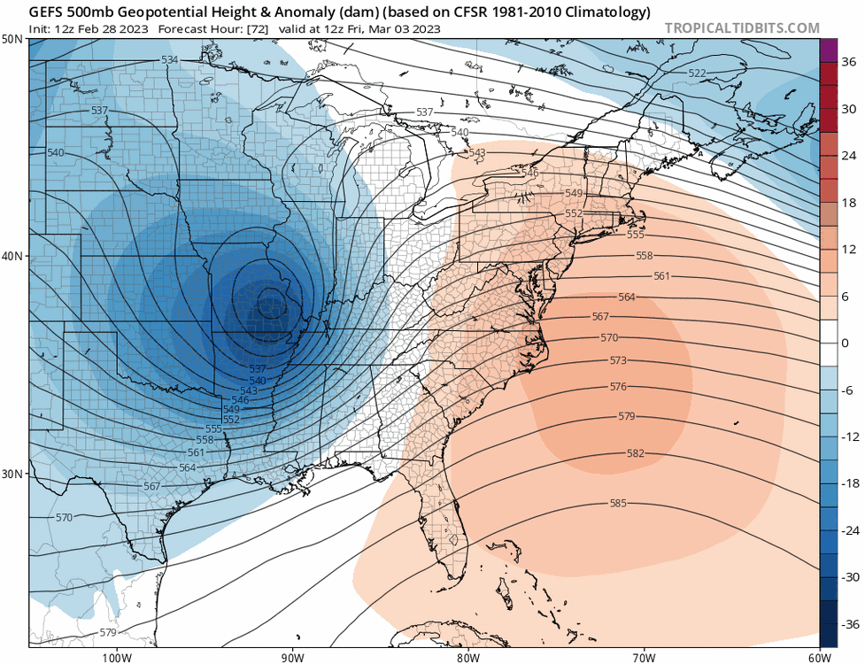
This winter will find many ways to screw us. GFS led the charge in this Fridays cutter. I know I just think it's funny how this winter will find multiple ways to screw us
-
Big cutter on the GFS
-
The big storms happen when the NAO decays. The transition from - to + means there's likely going to be a storm somewhere The AO also follows and the PNA is trending upwards all while a high amplitude phase 8 is occurring. This doesn't guarantee a mid March KU by any means. We've seen how a seemingly favorable pattern in December failed to produce but chances are better than normal
-
Yes it'll mainly be sleet. We don't have cold antecedent conditions in place which would give us a front end event
-
There's a real signal on the March 10-15 time frame for one last hurrah. Very fitting with the MJO plot.
-
Need to see more south trends today otherwise this is a non event for us
-
Any chance for a real coastal track?
-
Noteworthy trends for sure that introduces some frozen into the forum.
.thumb.gif.adbc0a2dad59a40e221b35df6ebf011b.gif)
-
That does look nice if it were to verify. Someone on the NE forum mentioned a pattern similar to March 1960
-
Typical 18z GFS shenanigans or something more because that was a pretty substantial move aloft.
-
Yes but we're also in that weird transitional phase where it can be in the 40s to 50 during the day and in the 20s with snow the next. If there's cold air to tap into then it will snow and based on those charts there will be a lot of cold around. My problem is there won't be storms around that can tap into the cold. But yes climo matters especially after mid March. You need anomalous cold + favorable storm track to get a significant snow event by then. There's only a handful of storms in our history that managed that.
-
Ensemble runs are smoothed out so there's likely to be colder days mixed in. So I think there's enough cold around but I don't see favorable storm tracks with the widespread CONUS cold. You need gradients for storms. This screams cold/dry to me. I assume most don't just want a cold March.
-
Same here. Instead I think it'll be annoyingly chilly and dry. Luckily the sun is getting higher and higher but I see a lot of murky, colder days with possibly more below freezing mornings than most of Jan & Feb.
-
Strong MJO 7 passage and Nina forcing really enhances the WAR for the 3/4 system. The confluence due to the blocking tries to blunt it but it's not enough for most.
-
Prepare to be disappointed
-
In Jan no but in March yes. Alternatively some of the ops also suggest an omega high like pattern with a bulging ridge in the southern plains and cold coasts. You could get some clippers or SWFEs as the lows go around the ridge. Repeats of yesterday
-
Correct. Both the December storm and this Friday are partially a result of a shrunken PV It takes more things to go right for us to score.
-
You have to adjust the MJO to the March Nina to get a better idea. MJO begins to lose relevance by March as well
-
I'm not complaining about it. It is what it is, you can't change the weather. I got some snow last night so it's better than nothing. But bad winters usually don't change that much in character and there's something to be said about persistence & repetition. But I hope it works out for someone. I'm on the cold/dry March train.
-
That's what's happening with the Friday storm and we still lose. Persistence usually works out well. We got lucky last night like we got lucky in other bad years like 01/02 but overall persistence wins. After looking at the March weeklies I'm going with cold/dry (-2 departure) and under 3" of snow mostly from clipper like systems.
-
Suppression depression. The only game in town is Friday. If that's a flop, looking likely, then it's BN & dry.

-
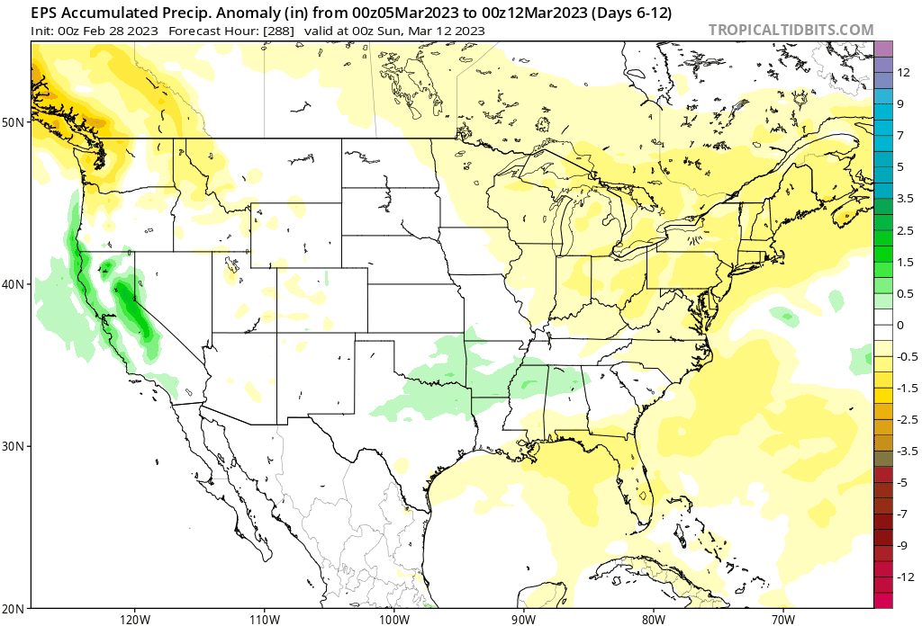
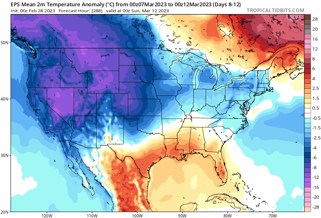
The extent of BN anomalies is impressive however the coldest air remains west. This would be a good look for DJF when climo is favorable. By mid March averages are pushing 50. The cold will equal 40s for highs and barely below freezing lows. On sunny days we could still get to 50+

-
That's a rain event or shredder. It's also a Day 13+ op so it doesn't matter. March should be good for New England where climo is still favorable. Not much to get excited about elsewhere. Coldest anomalies are still west.
-
There are no threats on the horizon after Friday and BN in March means highs in the 40s, not exactly wild.


.gif.608b46a0aa44fc48d4908df64cb367f9.gif)