

SnoSki14
-
Posts
16,066 -
Joined
-
Last visited
Content Type
Profiles
Blogs
Forums
American Weather
Media Demo
Store
Gallery
Everything posted by SnoSki14
-
Where's Brooklyn to tell us how good the GEFS looks
-
The only time the RNA won't be as damaging is by 2nd half of March due to wavelengths but by then you're fighting climo big time. Which is why I think it'll just be a chilly March 15 till early/mid April. NAO could stick around for a while so hopes of a warm early spring are very unlikely
-
What a fun rollercoaster that would be. 30s on Wednesday to low 70s Thursday and back to the 20s on Friday.
-
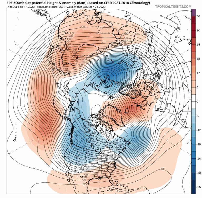
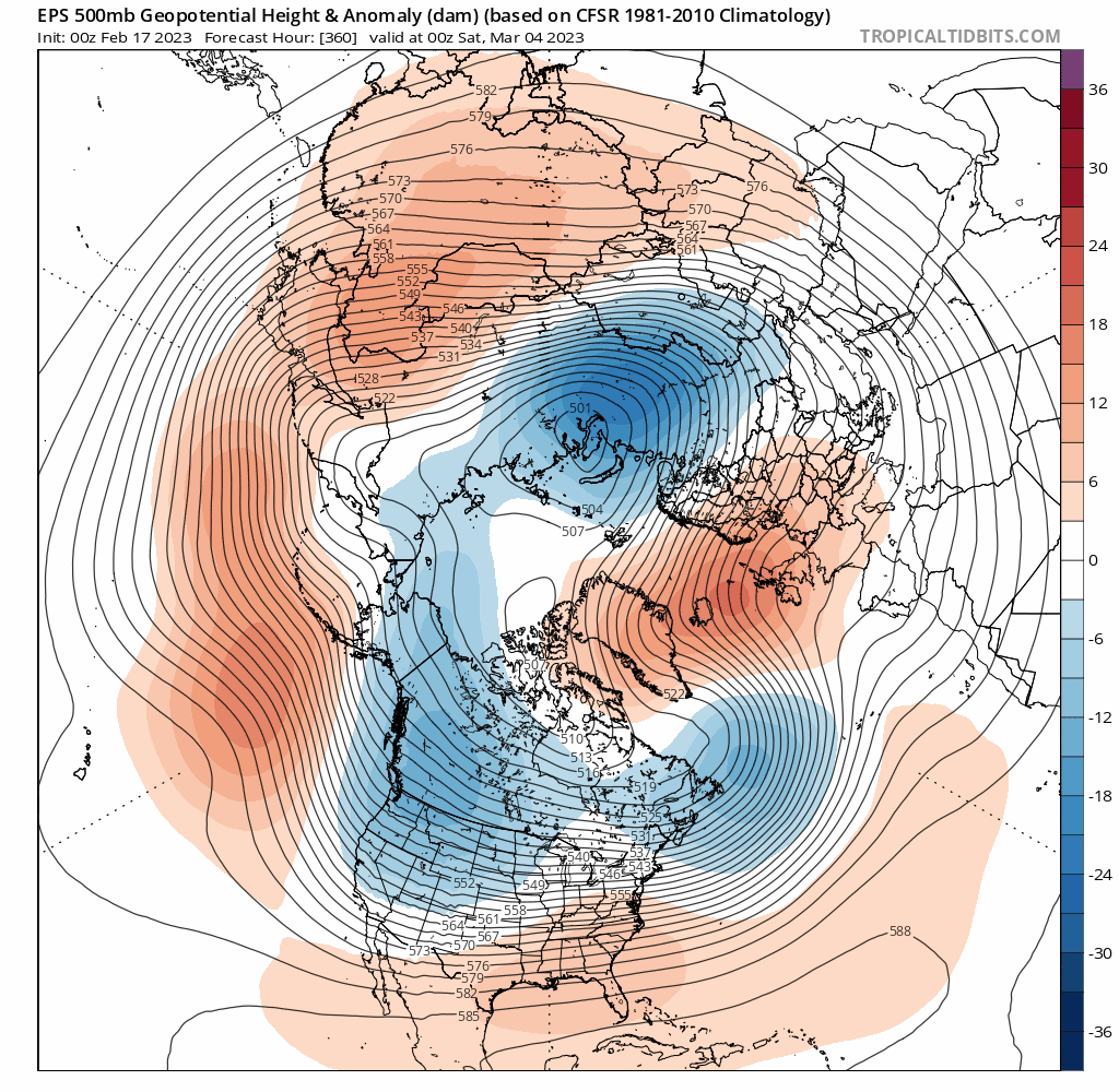
I think we're too far south to benefit. SNE could do well. Unfortunately I see us getting stuck between the very warm, sunny pattern (60s & 70s) and the cold, wintry one further north. So a lot of dreary 40s & 50s. The GFS has a very early spring backdoor looking pattern for us with a nasty cold tuck. That would only worsen under a -NAO blocking pattern. The 12z GFS is a perfect illustration of what I mean.
-
This won't cut it for March

-
The "blocking" shown on the EPS for March may only get us to near normal which by March is too warm for snow. I'm 50/50 percent sure we won't get any more snow this season
-
Hints of a PV press for the 23rd. Wouldn't be surprised to see that trend south and lead to icy conditions for northern areas
-
Except we're still barely BN as cold anomalies remain west. Additionally all it takes is a stronger -PNA to pump the SE ridge and we stay AN. I do think this will lead to a cold 2nd half of March into April as wavelengths shortern but by then it'll likely be too late for anything meaningful
-
If the arctic cold pool didn't shrink then this March would play out like 1956.
-
Yes things have warmed considerably since then. Looks like an east based -NAO too with a neutral PNA. Still a better analog than 2018 though
-
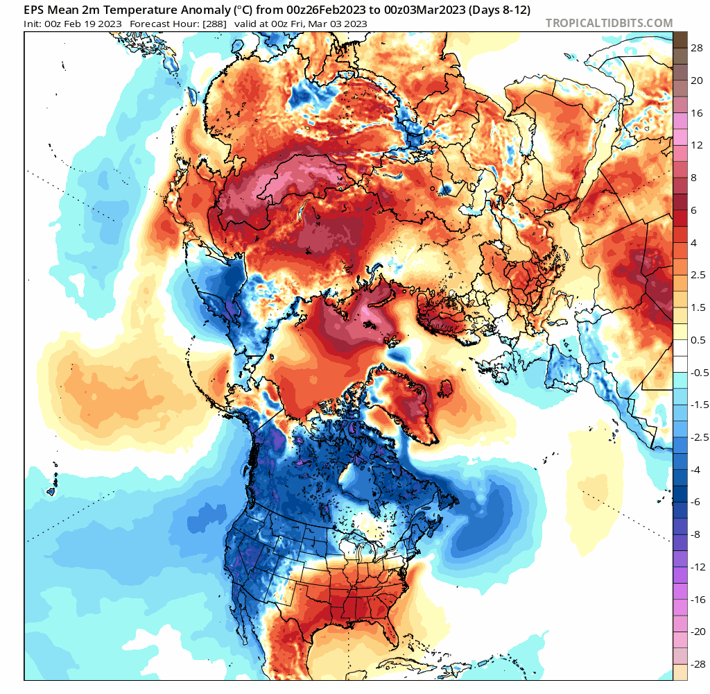
You can already see how that would set up a cold early spring with the shorter wavelengths. Not surprising that CFS shows a cool April.
-
Do you have a composite map of March 1956
-
Yes but you can see higher heights over Alaska and western Canada in March 2018 If you're just relying on the -NAO then that could easily link with the SE ridge under a strong RNA pattern. This is not a 2018 look. SE ridge would likely correct stronger. At best you can get a gradient pattern.
-
Yes that really keeps heights low in the 50/50 zone and staves off the southern ridge
-
GEFS show that as long as there isn't a ludicrously deep trough out west that things wouldn't be so bad after the 24th
-
Yeah but we can still get a snowy season with a higher baseline.
-
Maybe a nino in 23/24 will do the same. It certainly can't get much worse.
-
It fits the crappy pattern we've been in. Hell of a pattern out west though. CFS weeklies and monthly for March says winter is done.
-
We're going to blow past the other seasons. This year has been maximized to be really bad and this was with an "average" December too. Imagine if December were really warm. We're also on track to have the earliest spring leaf out in history which could be disastrous if we get any brief arctic intrusions in March.
-
Yeah I'm sure but the warm winters are definitely creating a feedback loop that only reinforces warm/less snowy winters. Hopefully we haven't hit some runaway cycle yet though I'm sure we will soon
-
I'm pretty sure most places have warmed several degrees in D-F over the last 100 years or so. Don & Bluewave always post great data on that This winter is an extreme warm outlier but still
-
A lot of people still think it's not a factor
-
CFS weeklies show how even a -NAO may not do anything
-
Leaf out approaching a full month ahead of schedule. First signs of spring now in NJ & near the city.
.thumb.png.a0733380cf6ec3e555cafa1c3af2a1e1.png)
-
As long as spring doesn't turn into winter then we're good. I'm sure most would be happy to leave this disaster of a winter behind them.


.png.7f85a095311c4fcdccba1632e297b092.png)
