Hurricane Agnes
-
Posts
9,336 -
Joined
Content Type
Profiles
Blogs
Forums
American Weather
Media Demo
Store
Gallery
Everything posted by Hurricane Agnes
-
E PA/NJ/DE Fall 2024 Obs/Discussion
Hurricane Agnes replied to Rtd208's topic in Philadelphia Region
When I used to have a saltwater reef tank, I actually DID have a RO setup that I ran the water through! Don't forget the inevitable "dry slot" that opens up over YBY! Finally caved and turned the heat on (and knew I needed to get the humidifiers going with it). Made it up to 48 for a high today and it's currently 35 with dp 26. -
E PA/NJ/DE Fall 2024 Obs/Discussion
Hurricane Agnes replied to Rtd208's topic in Philadelphia Region
It IS (mostly) Schuylkill Punch. https://billypenn.com/2015/06/18/schuylkill-punch-why-philly-tap-water-tastes-this-way-and-why-its-not-bad-for-you-really/ There are 2 intakes along the Schuylkill River and 1 adjacent to the Delaware River, the latter one that generated some drama when there was a chemical spill in Bristol, not far from the intake - https://water.phila.gov/drops/phila-water-dept-monitoring-spill-at-bucks-county-facility/. I use a Pur filter on my faucet for drinking purposes anyway. Had my first "at freezing" (32) temp since March 25, just after 5:30 this morning, and it's currently sunny and 37, with dp a dry 26. -
E PA/NJ/DE Fall 2024 Obs/Discussion
Hurricane Agnes replied to Rtd208's topic in Philadelphia Region
That is maybe for "suburban Philly" (e.g., for the Aqua Pennsylvania servicing area), but our water (PWD) comes from a couple sources including the Wissahickon Watershed (and several other watersheds in and around the city) And then of course, the Delaware River (that obviously starts way up in NY where they are also having some drought issues). https://water.phila.gov/watersheds/wissahickon/ As an obs, I bottomed out at 49 this morning and it's possible my "high" of 57 will be at midnight. Currently sunny and 51 with dp 35. -
E PA/NJ/DE Fall 2024 Obs/Discussion
Hurricane Agnes replied to Rtd208's topic in Philadelphia Region
And the record dry spell IMBY has ended at 41 days, resulting in 0.15" before midnight and another 0.21" after midnight, with the heaviest between 1 am - 2 am. The 2-day event total is 0.36" so far. It's currently a misty 58 with dp 57. -
E PA/NJ/DE Fall 2024 Obs/Discussion
Hurricane Agnes replied to Rtd208's topic in Philadelphia Region
No tipsy of the bucket from that round 1. I guess since the "main event" wasn't progged until later this afternoon and overnight, perhaps another round will be able to get over that hurdle! Otherwise I'll be at day 42 of non-measurable.- 1,105 replies
-
- 1
-

-
- tropics
- heavy rainfall
- (and 5 more)
-
E PA/NJ/DE Fall 2024 Obs/Discussion
Hurricane Agnes replied to Rtd208's topic in Philadelphia Region
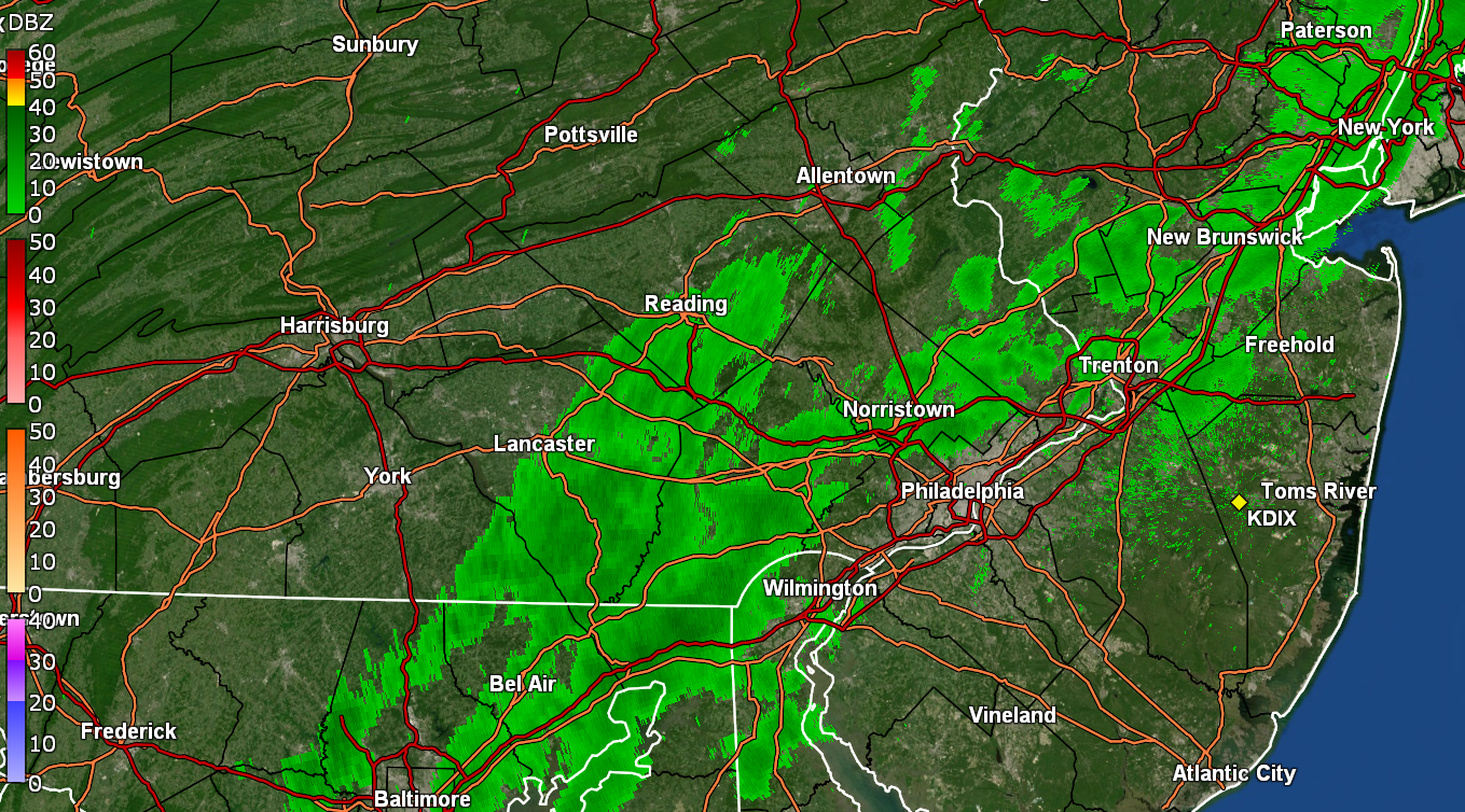
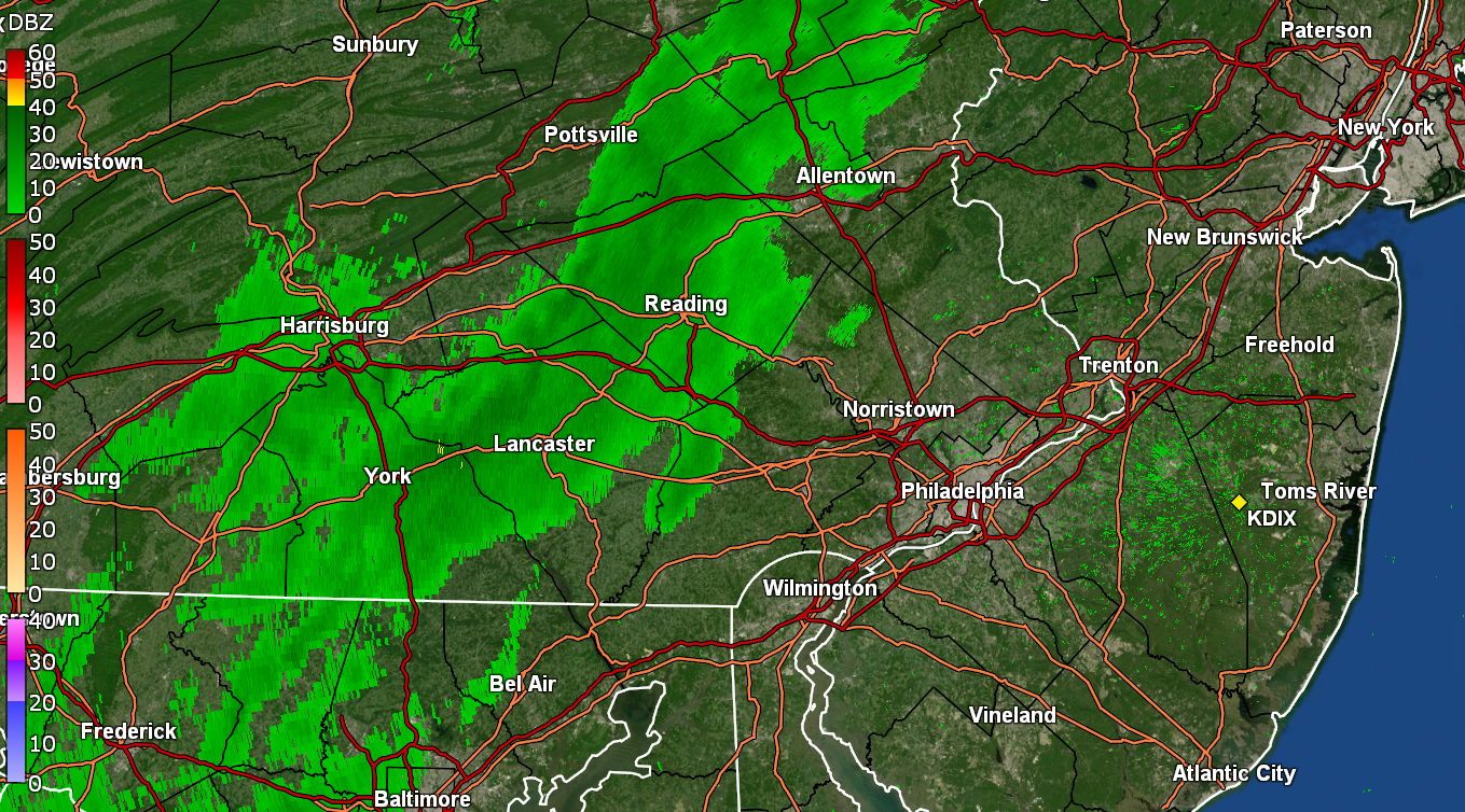
Am getting a "wetting event" but bucket hasn't tipped yet. Will it do it this time? Stay tuned! Temp is 55 with dp 46.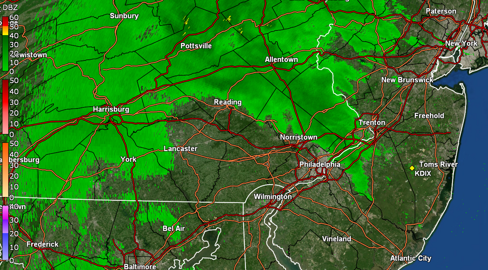
-
E PA/NJ/DE Fall 2024 Obs/Discussion
Hurricane Agnes replied to Rtd208's topic in Philadelphia Region
I was just out putting down my patio umbrella and was like WTF? Droplets! They were strays and so far not amounting to anything close to my non-measurable "wetting event" on Nov. 1st, but still something with more potential to the west. I actually bottomed out at 34 this morning, which was my coldest since March 25, thanks to the bone dry air mass (dp was 26 at that point), 0 wind, and perfect radiational cooling. It's currently overcast.dripping, and 55, with dp that has recovered to 42. ETA - I am up to 41 days of non-measurable up to today. Am hoping to get something measurable today.- 1,105 replies
-
- 2
-
-
- tropics
- heavy rainfall
- (and 5 more)
-
E PA/NJ/DE Fall 2024 Obs/Discussion
Hurricane Agnes replied to Rtd208's topic in Philadelphia Region
Finally getting actual droplets from the sky. It's a miracle. Probably will end up unmeasurable but at least a trace since I didn't get that last trace that came through, and this has wet the car windshield and is somewhat wetting the sidewalk. Currently drizzling and 67 with dp 60.
-
E PA/NJ/DE Fall 2024 Obs/Discussion
Hurricane Agnes replied to Rtd208's topic in Philadelphia Region
Temp whiplash time from bottoming out at 35 on Oct. 28, to hitting a high of 80 here yesterday. Also not a drop (not even a trace or fog trace either) for the entire month of Oct. IMBY. The last measurable here was 0.05" on Sept. 29. It's currently a mild 66 with dp 59 and a line of some sort, headed this way but my pessimism says it may start to breakup and/or thin out before it gets here.
-
E PA/NJ/DE Fall 2024 Obs/Discussion
Hurricane Agnes replied to Rtd208's topic in Philadelphia Region
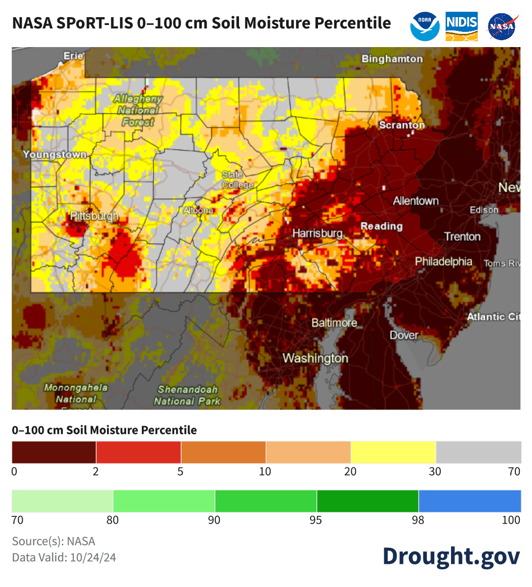
That's not the purpose of the map. For general "drought" stats, there are other maps. Here is a description of what NOAA uses for that - https://www.drought.gov/data-maps-tools/nasa-sport-lis-soil-moisture-products And there are obviously sensors/probes available as well (I have a bunch of Ambient ones that I use that communicate with my weather station). Current CONUS map below.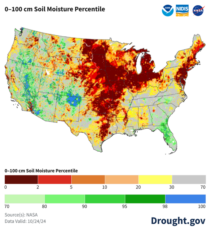
- 1,105 replies
-
- 2
-
-
- tropics
- heavy rainfall
- (and 5 more)
-
E PA/NJ/DE Fall 2024 Obs/Discussion
Hurricane Agnes replied to Rtd208's topic in Philadelphia Region
Last rain IMBY was on 9/29, with nothing since - not even something that could have been considered "unmeasurable", even if wetting the walks. Almost reminds me of what happened in 2001 after 9/11. That "dry" had extended up into NY through the winter as well where I remember thinking about how they would even try to clear the WTC debris in the midst of snowstorms and none ever really appeared that winter. The result was some excessive heat and a period of drought during the summer of 2002 though. I found a good map - for soil moisture from drought.gov, that I think reflects why we all consider this pretty bad! It does look cyclic though = For some obs - my coldest so far this month was the low of 38 on 10/17 and alternately, I made it to 82 for a high this past Tuesday. It's currently 61 with dp 53.
- 1,105 replies
-
- 1
-

-
- tropics
- heavy rainfall
- (and 5 more)
-
E PA/NJ/DE Fall 2024 Obs/Discussion
Hurricane Agnes replied to Rtd208's topic in Philadelphia Region
Okay good because I can imagine.- 1,105 replies
-
- 1
-

-
- tropics
- heavy rainfall
- (and 5 more)
-
E PA/NJ/DE Fall 2024 Obs/Discussion
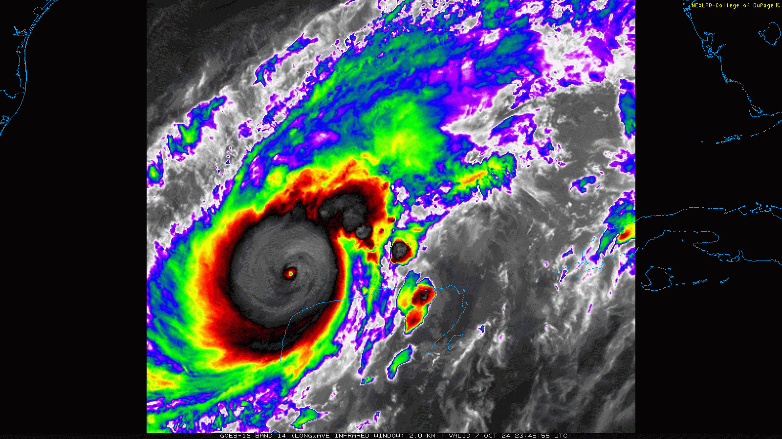
Hurricane Agnes replied to Rtd208's topic in Philadelphia Region
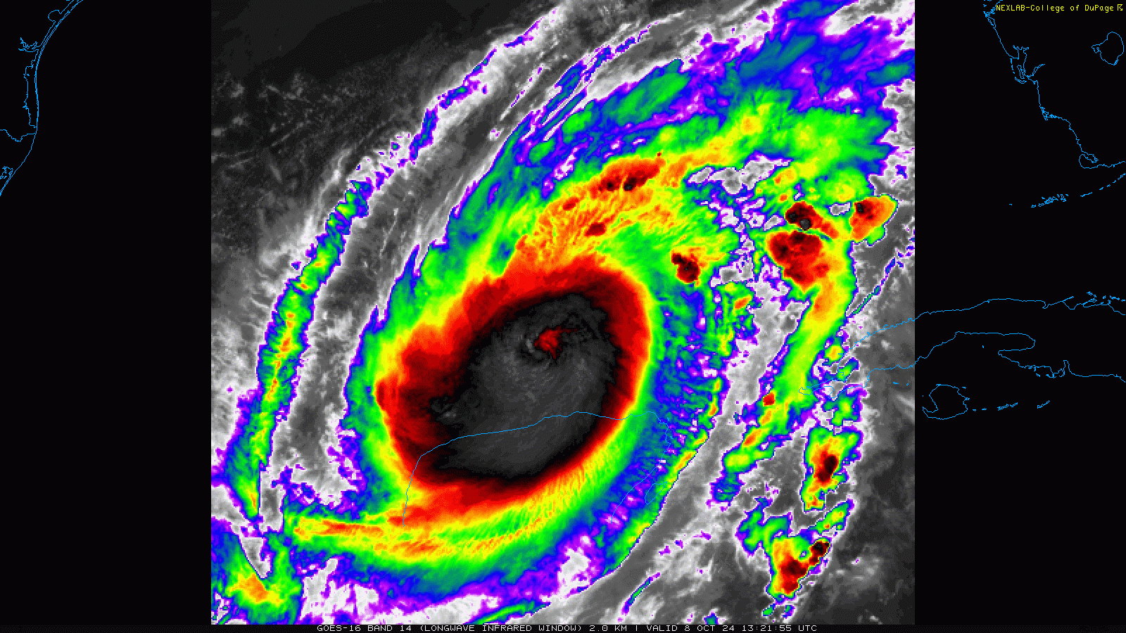
Since it did an ERC, will have to see whether it stays compact and tightly would or expands out. You can see the difference between the pinhole (last night) and darning needle size eyes (). You can also see how it has finally started moving more quickly vs almost sitting and spinning in place.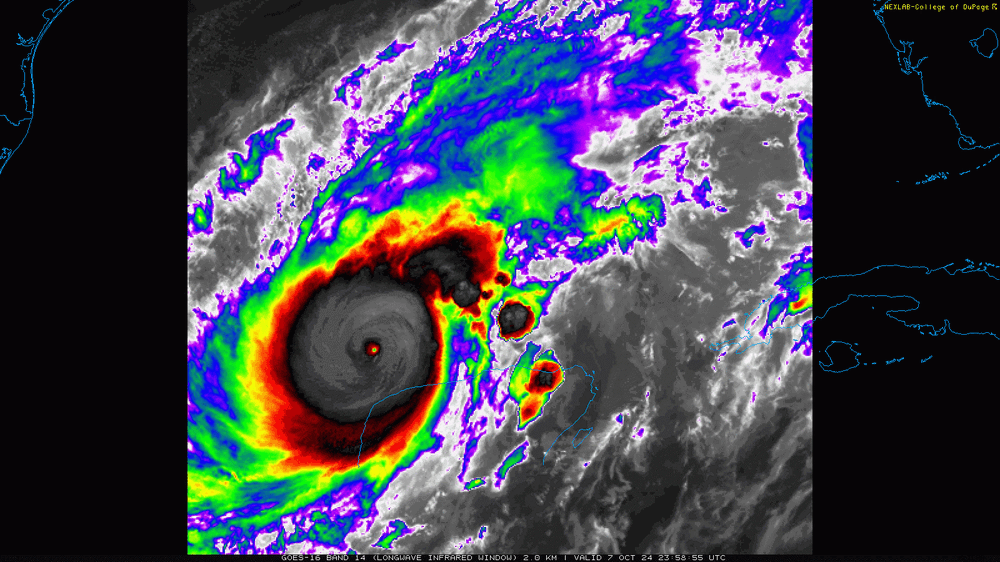
- 1,105 replies
-
- 1
-

-
- tropics
- heavy rainfall
- (and 5 more)
-
E PA/NJ/DE Fall 2024 Obs/Discussion
Hurricane Agnes replied to Rtd208's topic in Philadelphia Region
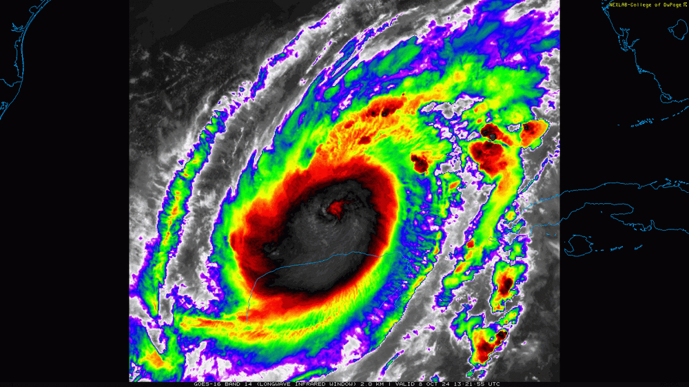
It scraped up against the Yucatan and did an ERC! Last update had it down to 145 mph and it's back up to about 917. Had heard yesterday that Disney World would stay open but I doubt that at this point. Temp here is creeping up and am now at 59 with a nice low dp of 49.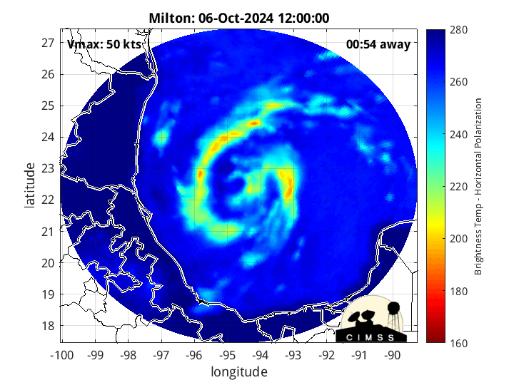
- 1,105 replies
-
- 1
-
-
- tropics
- heavy rainfall
- (and 5 more)
-
E PA/NJ/DE Fall 2024 Obs/Discussion
Hurricane Agnes replied to Rtd208's topic in Philadelphia Region
Well I made it through September with <1" of rain (0.68"), literally dribs and drabs, hundredths of an inch at a time. So far I have zero measurable for October. It made it up to 75 today after a 62 low and it's currently 65, with dp 49. But in other news - OMFG Hurricane Milton. Central pressure down to 919 and sustained winds 180 mph.
- 1,105 replies
-
- 1
-
-
- tropics
- heavy rainfall
- (and 5 more)
-
E PA/NJ/DE Fall 2024 Obs/Discussion
Hurricane Agnes replied to Rtd208's topic in Philadelphia Region
So far I have 0.03" in the bucket today, the 2nd highest daily total for the month and enough to finally get me over the 0.1" mark for a whopping 0.12" for the month of September. After a low of 60 this morning, I made it up to 68 for a high and it's currently overcast and 63 with dp 59. -
E PA/NJ/DE Fall 2024 Obs/Discussion
Hurricane Agnes replied to Rtd208's topic in Philadelphia Region
Don't forget the obscured Full Super Harvest Moon partial eclipse! I managed to eek out 0.02" yesterday morning, which comes out to almost 1/4 of my entire September rainfall which has yet to breach the tenth of an inch mark (am at 0.09" so far). After a mild 70 low yesterday, I made it to 76 as a high. It's currently 64 with dp 60. -
E PA/NJ/DE Fall 2024 Obs/Discussion
Hurricane Agnes replied to Rtd208's topic in Philadelphia Region
Bottomed out at 50 this morning, the coolest low since May 13 (that had a low of 43). Made it up to 77 for a high. Currently mostly sunny and 75 with dp 50, which is nothing to complain about temperature and humidity wise. Need some rain though. Currently have 0.07" for the month so far. -
E PA/NJ/DE Fall 2024 Obs/Discussion
Hurricane Agnes replied to Rtd208's topic in Philadelphia Region
Something came through overnight to give me 0.01", making for a 2-day of 0.06". Will probably have to pull out the hose again. I bottomed out at 51 this morning and it took awhile to finally hit 70, and did make it to 71 for a high at about 3:30 pm today. It's currently a mostly sunny 68 with a big bonus - a dp of 43. In other news, PTC-6 is here, so may become a Francine eventually. Based on the current cone, we might be able to get some of that moisture here at some point if it accompanies a front.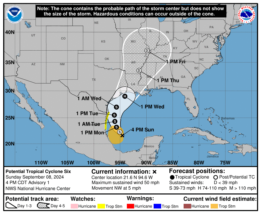
-
E PA/NJ/DE Fall 2024 Obs/Discussion
Hurricane Agnes replied to Rtd208's topic in Philadelphia Region
Well I made it up to 77 for a high today and Mt. Holly was right about the hit or miss chances with the rain as I only got 0.05" with the pre-frontal line that was literally opening up a hole over me, and the post-frontal that finally cleared, merely wet the walk with nothing more measurable. It did manage to dramatically drop my temp almost 15 degrees when it came through. I am currently at my "low" for the day, which is cooler than whatever it was this morning, and clearing, with dp 59.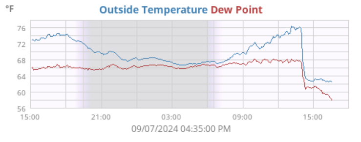
-
E PA/NJ/DE Fall 2024 Obs/Discussion
Hurricane Agnes replied to Rtd208's topic in Philadelphia Region
My low of 52 this morning was the coolest since May 31st and I made it up to 77 for a high for another beautiful day. It's currently a mostly sunny 75 with dp creeping up a bit to a still-okay 53. -
E PA/NJ/DE Fall 2024 Obs/Discussion
Hurricane Agnes replied to Rtd208's topic in Philadelphia Region
Bottomed out at 54 this morning (although the last time I was that low was Aug. 21st), and made it up to 73 for a high. With dews in the 40s, you couldn't ask for a more perfect day. It's currently 73 and mostly sunny with dp 45. -
E PA/NJ/DE Fall 2024 Obs/Discussion
Hurricane Agnes replied to Rtd208's topic in Philadelphia Region
Well happy met Fall! Last Friday, I ended up with 0.20" of ran to finish August with 6.02", but not distributed as well as I would have liked. I had some spritzes yesterday that wet the walk but didn't tip the bucket but did manage a 0.01" overnight after midnight. After a low of 72 yesterday, I made it up to 85 for the first day of September. With the frontal passage this morning just after 2 am, the dews dropped out of the 70s and it's currently mostly cloudy and 66 with dp 58. There have been articles about the possible formation of an Atlantic La Nina (and also mentioned in a NOAA Blog post) - https://www.climate.gov/news-features/event-tracker/atlantic-nina-verge-developing-heres-why-we-should-pay-attention- 1,105 replies
-
- 2
-
-
- tropics
- heavy rainfall
- (and 5 more)
-
E PA/NJ/DE Summer 2024 Obs/Discussion
Hurricane Agnes replied to JTA66's topic in Philadelphia Region
Yeah, the (met) "Summer" thread is JJA and (met) "Fall" is SON. Well since we are just under 3 hours before sunset, it looks like my high for today was 95. Lots of cumulus have funneled in and it's currently partly sunny and 92 with dp 74. -
E PA/NJ/DE Summer 2024 Obs/Discussion
Hurricane Agnes replied to JTA66's topic in Philadelphia Region
Need rain! Had to pull out the hose on Sunday and the last rain that I had IMBY was 0.04" 9 days ago. I have had 5.82" for the month, which ain't bad at all, but most of it was at the beginning of the month and then things dried up. After a low of 72 this morning, It's currently a sunny 88 with dp 74. I expect to hit in the 90s today and that would give me 90+ day #6 for the month. And with 15 90+ days in July + 8 in June, would be a total of 29 for the season to date., which is pretty high for me. I normally only get about 1/2 of that. We never started before Labor Day when I was in the schools in the '60s and '70s. That was something "new" that started in 2018 - 2019 (and that idea quickly ended thanks to a heatwave). The following years were hit with the pandemic and remote school, and then the before Labor Day was tried again in 2022 - 2023 and... with 1/2 days. Last year they started after Labor Day and did miss any excessive heat. The Superintendents that they keep bringing in keep fantasizing that the 100-year old school buildings (mostly elementary and middle schools) are only a couple decades old and they are obviously not. And then you even had Jalen Hurts donate $200,000 worth of window ACs for the schools but they can't even install them because of the old electric circuits and wiring in the classrooms (probably lots of 15 amp ones). I watched during my niece's lifetime, where her district (Springfield Township, Montco) built not one but TWO brand new schools (an elementary and a middle) from the ground up. Meanwhile this past January, the first brand new school built in North Philly in 70 years, was finally opened- https://whyy.org/articles/thomas-m-peirce-school-new-philadelphia/ A 2nd brand new school just opened in West Philly last week - https://www.chalkbeat.org/philadelphia/2024/08/20/school-built-with-community-help-features-innovation-lab-and-new-playground/ No that's not why. They were trying to end earlier to -get this- "avoid the heat" in June. During and after the pandemic, since they have actually set up a "remote class" plan, they pretty much got rid of snow days. That definitely pissed off the kids because there is very little now (at least weather-wise) that would close the schools. I.e., no more "snow days". What they'll do in some cases is have kids come in and get a half-day if there is some kind of weather-related issue during the school day, and that will count as a "full day" for state purposes.