Hurricane Agnes
-
Posts
9,336 -
Joined
Content Type
Profiles
Blogs
Forums
American Weather
Media Demo
Store
Gallery
Everything posted by Hurricane Agnes
-
E PA/NJ/DE Summer 2024 Obs/Discussion
Hurricane Agnes replied to JTA66's topic in Philadelphia Region
Saw I was under a FFW - Sky is clearing and sun wants to come out. It was dusty dry before that! -
E PA/NJ/DE Summer 2024 Obs/Discussion
Hurricane Agnes replied to JTA66's topic in Philadelphia Region
LOL It's getting there. Looks like a big blob just south of Trenton. Rain finally stopped here and now have 1.62" in the buckt. Temp is down to 64 with dp 63 so that cell dropped the temp over 20 degrees. Might be some more behind that. -
E PA/NJ/DE Summer 2024 Obs/Discussion
Hurricane Agnes replied to JTA66's topic in Philadelphia Region
As a PNS or skywarn? Haven't actually done one before. -
E PA/NJ/DE Summer 2024 Obs/Discussion
Hurricane Agnes replied to JTA66's topic in Philadelphia Region
Yeah it was weird with little wind (didn't really get a gust front per se) but did finally get breezy after the cell moved on. -
E PA/NJ/DE Summer 2024 Obs/Discussion
Hurricane Agnes replied to JTA66's topic in Philadelphia Region
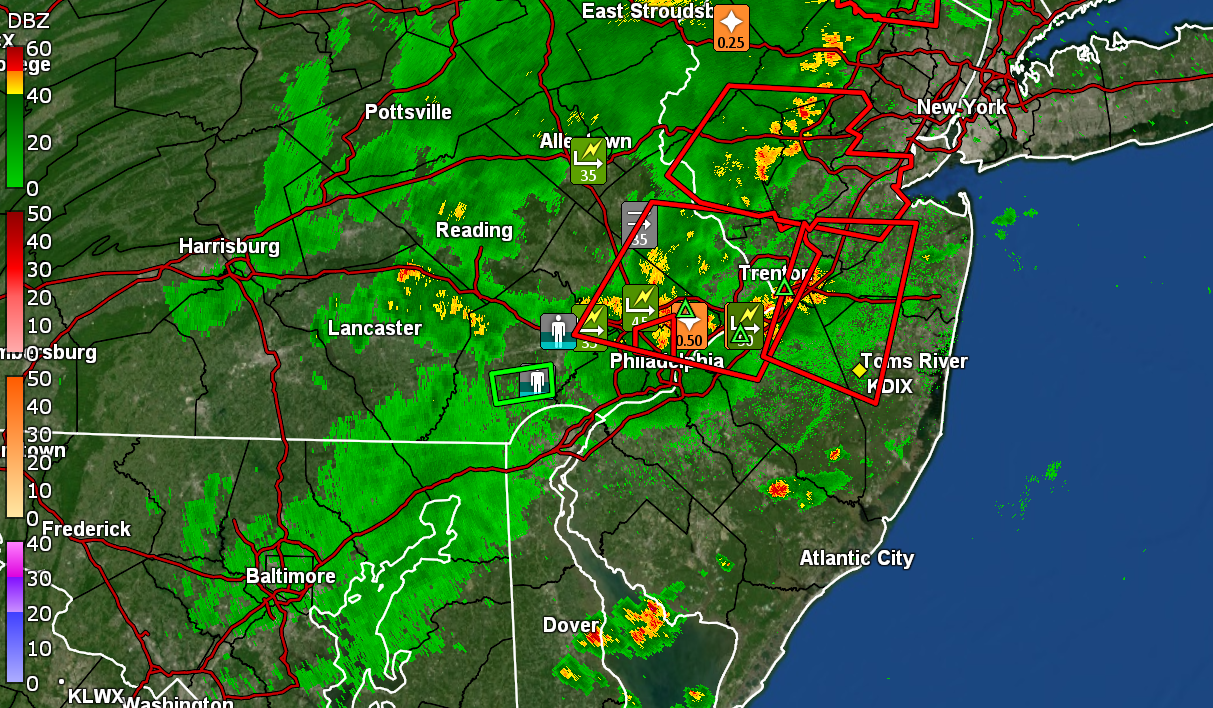
Well at least I won't have to pull out the hose for a few days. Now hav 1.49" in the bucket and another little cluster coming through. Just over 1.5"/hr rate. Temp down to 66 with dp 64. Radar is busy!
-
E PA/NJ/DE Summer 2024 Obs/Discussion
Hurricane Agnes replied to JTA66's topic in Philadelphia Region
I was right under a pop-up cell. The weather station reported a highest rain rate of 4.56"/hr at one point. Currently have 1.31" in the bucket and still just over 1"/hr rate. Am also getting some wind. -
E PA/NJ/DE Summer 2024 Obs/Discussion
Hurricane Agnes replied to JTA66's topic in Philadelphia Region
Ha! Now up to 1.20" in teh bucket. Still have >3.5" rain rate. Temp 68 with dp dropping now at 67. -
E PA/NJ/DE Summer 2024 Obs/Discussion
Hurricane Agnes replied to JTA66's topic in Philadelphia Region
Now just over 3.5"/hr rate. Have 0.77" in the bucket. Temp 69 w/dp 67. Had one loud thunder. -
E PA/NJ/DE Summer 2024 Obs/Discussion
Hurricane Agnes replied to JTA66's topic in Philadelphia Region
Now almost >3" hour rates. Have 0.65" in the bucket. -
E PA/NJ/DE Summer 2024 Obs/Discussion
Hurricane Agnes replied to JTA66's topic in Philadelphia Region
Now have 0.33" in the bucket with rates 1.5"/hr. Temp down to 72 with dp 69. -
E PA/NJ/DE Summer 2024 Obs/Discussion
Hurricane Agnes replied to JTA66's topic in Philadelphia Region
Am now under a STW. Getting >3/4"/hr rates and have 0.14" in the bucket at post time. Lots of convection being picked up on the lightning detector.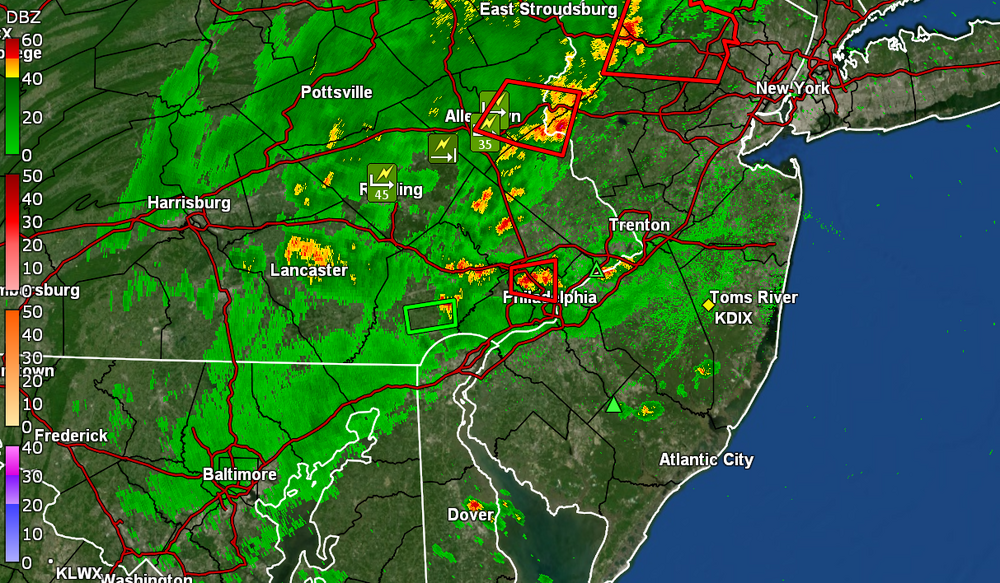
-
E PA/NJ/DE Summer 2024 Obs/Discussion
Hurricane Agnes replied to JTA66's topic in Philadelphia Region
Excellent! -
E PA/NJ/DE Summer 2024 Obs/Discussion
Hurricane Agnes replied to JTA66's topic in Philadelphia Region
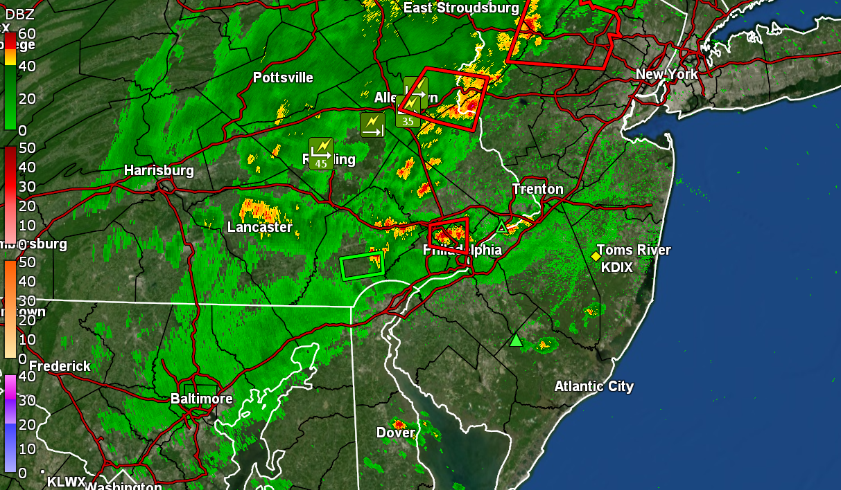
I think Mt. Holly said it was a pre-frontal trough. Right now the radar has all kinds of junk and stuff bubbling up. Hope you get your power back quick though! -
E PA/NJ/DE Summer 2024 Obs/Discussion
Hurricane Agnes replied to JTA66's topic in Philadelphia Region
Getting some big splats. Put the patio umbrella down. Temp now 85 with dp 70. My high will most likely be that 90 earlier. -
E PA/NJ/DE Summer 2024 Obs/Discussion
Hurricane Agnes replied to JTA66's topic in Philadelphia Region
Here we go! Currently overcast IMBY and 86 with dp 69. -
E PA/NJ/DE Summer 2024 Obs/Discussion
Hurricane Agnes replied to JTA66's topic in Philadelphia Region
Made it up to 88 for a high yesterday and after a 69 "low" this morning, I have hit 90 now for a current and dp 69, with partly sunny skies and lots of cumulus (including some dark stuff rolling in from the west). Looks like an early line so might be pre-frontal.
-
E PA/NJ/DE Summer 2024 Obs/Discussion
Hurricane Agnes replied to JTA66's topic in Philadelphia Region
El Nino is officially dead. La Nina watch (65% chance for it this summer)! After a 60 low, have so far hit 87 for a high today. And since we are dry (I have only had 0.60" of rain in June so far), that can help temps soar next week if we don't get a bit of a soaking ahead of the incoming heatwave. -
E PA/NJ/DE Summer 2024 Obs/Discussion
Hurricane Agnes replied to JTA66's topic in Philadelphia Region
Looks like the cluster that formed earlier is fizzling as it approaches Philly. After a low of 69, I did get up to 86 for a high. It's currently an overcast and muggy 82 with dp 73 and "Feels Like" of 88. -
E PA/NJ/DE Summer 2024 Obs/Discussion
Hurricane Agnes replied to JTA66's topic in Philadelphia Region
Ended up with 0.58" between last night and early this morning (0.49" _ 0.09"). Watches are up! Currently an overcast and icky 82 with dp 72. -
E PA/NJ/DE Spring 2024 OBS/Discussion
Hurricane Agnes replied to Hurricane Agnes's topic in Philadelphia Region
A thicker line fizzled as it started coming over me although I'm getting some light - moderate rain. Currently have 0.07" in the bucket. -
E PA/NJ/DE Spring 2024 OBS/Discussion
Hurricane Agnes replied to Hurricane Agnes's topic in Philadelphia Region
Lots of convection in that bowed line. Have gotten splats as it has approached. Temp 69 and dp 60. -
E PA/NJ/DE Spring 2024 OBS/Discussion
Hurricane Agnes replied to Hurricane Agnes's topic in Philadelphia Region
Whatever was left from that broken line gave me 0.01" sometime around 11pm on top of the 0.88" that I had earlier, for 0.89" total for the day. My high ended up being 77. This after an 89 high on Sunday (with low of 69). Currently clearing with sun breaking through the clouds just after sunrise, and 66 with dp 64. -
E PA/NJ/DE Spring 2024 OBS/Discussion
Hurricane Agnes replied to Hurricane Agnes's topic in Philadelphia Region
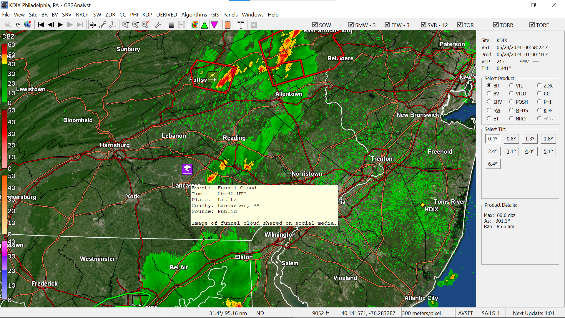
Looks like a report of a funnel cloud near Littiz.
-
E PA/NJ/DE Spring 2024 OBS/Discussion
Hurricane Agnes replied to Hurricane Agnes's topic in Philadelphia Region
Sun just popped out here again. May end up being a self-destruct sunshine type of scenario. Don't know if those cells will ever consolidate on their way here but if the sun manages to stay out long enough before setting, a few more might fill in the gaps in the current line. -
E PA/NJ/DE Spring 2024 OBS/Discussion
Hurricane Agnes replied to Hurricane Agnes's topic in Philadelphia Region
Sun briefly popped out completely here but not quite long enough to fire up the temps (it clouded up again), although it did go up a degree to 73. Dewpoint is still oppressive at 71. The actual cold front is still back where that broken line is, but we only have a couple hours left before sunset. ETA - looks like Delaware was added to the Watch with the MD counties -