Hurricane Agnes
-
Posts
9,342 -
Joined
Content Type
Profiles
Blogs
Forums
American Weather
Media Demo
Store
Gallery
Everything posted by Hurricane Agnes
-
E PA/NJ/DE Spring 2024 OBS/Discussion
Hurricane Agnes replied to Hurricane Agnes's topic in Philadelphia Region
M 4.8 - 5 km NE of Lebanon, New Jersey -
E PA/NJ/DE Spring 2024 OBS/Discussion
Hurricane Agnes replied to Hurricane Agnes's topic in Philadelphia Region
YES!! Started around 10:23 and ended around 10:24 !!! Maybe about 20 seconds. -
E PA/NJ/DE Spring 2024 OBS/Discussion
Hurricane Agnes replied to Hurricane Agnes's topic in Philadelphia Region
Now I'll have that song as an earworm the rest of the evening! Had a brief warm-up where I managed to hit 54 for a high just after 2 pm. I also got a brief shower to give me another 0.01" for 0.25" for the day (so far) and 3.08" over the 3 days. There's an incoming cluster of something so that might add to the total later tonight. Currently 44 with dp 41. -
E PA/NJ/DE Spring 2024 OBS/Discussion
Hurricane Agnes replied to Hurricane Agnes's topic in Philadelphia Region
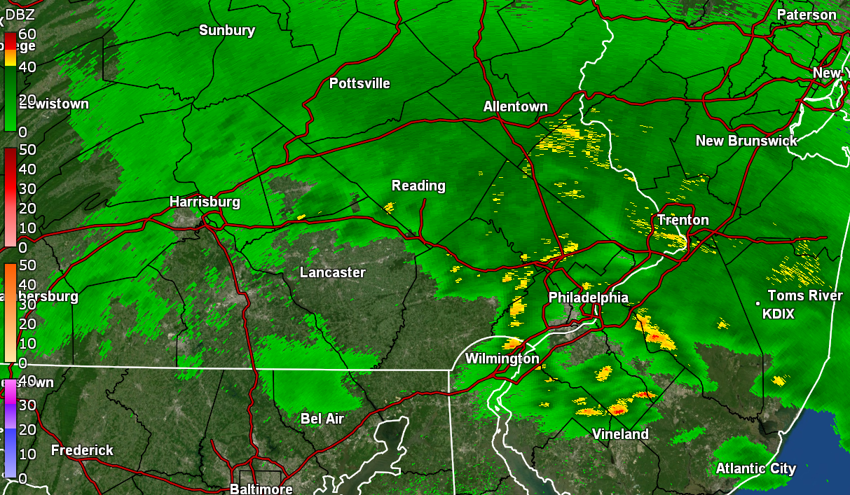
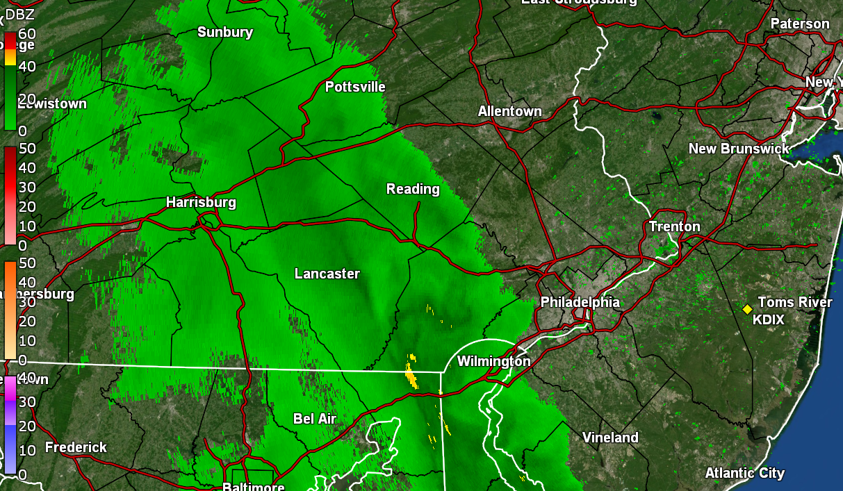
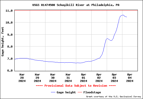
Got an additional 0.22" last night to finish up with 1.75" for yesterday. And with another 0.24" earlier this morning, I so far have 3.07" for a 3-day event total. There is an odd yellow orb in the sky this morning, and after bottoming out at 38, it's currently partly sunny and 39 with dp 39. ETA - So far have 3.75" of rain for the month and the Wissahickon creek is pretty much lapping the banks and the Schuylkill @ PHL just barely missed flood stage (so far) but might still get there if the rain picks up again.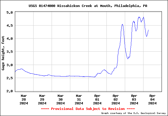
-
E PA/NJ/DE Spring 2024 OBS/Discussion
Hurricane Agnes replied to Hurricane Agnes's topic in Philadelphia Region
They sure have for the past couple hours. Currently in a rain lull again after a long round 2. Picked up an additional 0.28" giving me 1.53" for the day (2.61" 2-day total). My high ended up being 44 at midnight. Currently a windy and misty 42 with dp 42, and low stratus. -
E PA/NJ/DE Spring 2024 OBS/Discussion
Hurricane Agnes replied to Hurricane Agnes's topic in Philadelphia Region
Looks like a Tornado Watch is up for the southern part of the CWA (Delaware) - -
E PA/NJ/DE Spring 2024 OBS/Discussion
Hurricane Agnes replied to Hurricane Agnes's topic in Philadelphia Region
Just had a rolling thunder. Definitely audible although not directly near but a bit distant. ETA - getting a thunderstorm now. Heavier rain and more persistent thunder.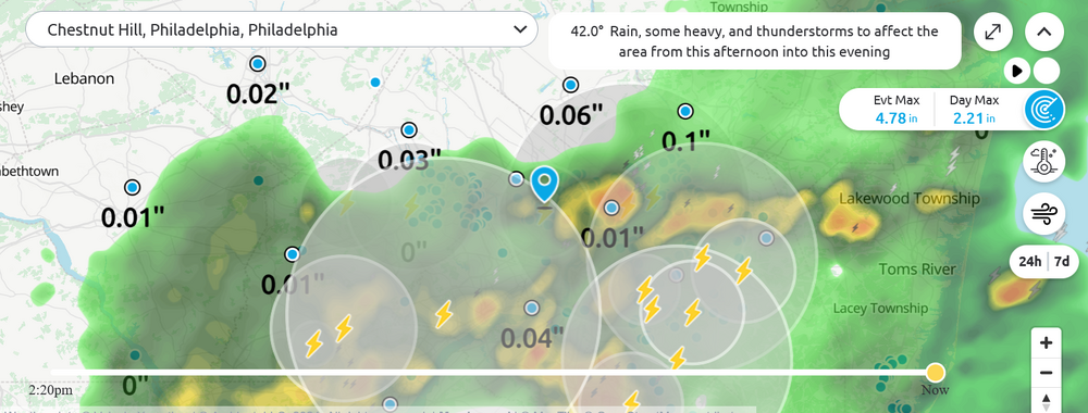
-
E PA/NJ/DE Spring 2024 OBS/Discussion
Hurricane Agnes replied to Hurricane Agnes's topic in Philadelphia Region
Since this morning, I have picked up another 0.70" of rain for 1.25" for the day so far and heard my first thunder (albeit soft) about 5 minutes ago. Total so far for the 2-day event is 2.33". Currently getting light rain and temp is down to 42 with dp 42. -
E PA/NJ/DE Spring 2024 OBS/Discussion
Hurricane Agnes replied to Hurricane Agnes's topic in Philadelphia Region
Am in a little rain lull at the moment with the finishing up of a round 1 that added an additional 0.20" to the tally since my last post, for a total of 0.50" at post time (1.62" 2-day). Temp has dropped down to 43 with dp 43 and it is currently overcast, breezy, and misty. -
E PA/NJ/DE Spring 2024 OBS/Discussion
Hurricane Agnes replied to Hurricane Agnes's topic in Philadelphia Region
My lightning detector has been firing between 2 am and now as a little disturbance comes through. Haven't personally seen the lightning and haven't heard any thunder but something is going on! Finished up with 1.30" of rain yesterday and currently have 0.30" this morning for a 2-day total so far of 1.60". Currently light rain and 44 with dp 43. Had been using KDOX when KDIX was flakey.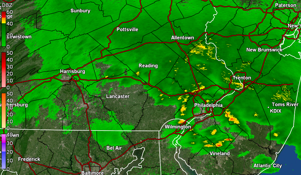
-
E PA/NJ/DE Spring 2024 OBS/Discussion
Hurricane Agnes replied to Hurricane Agnes's topic in Philadelphia Region
Temp has stayed pretty steady much of the day and round 3 gave me another 0.60" for a total of 1.23" for the day so far. Round 4 looks to be out in western PA, probably due here overnight and into tomorrow, triggering formation of a nor'easter at some point. Currently in a rain lull but it's misty and 45, with dp 45. -
E PA/NJ/DE Spring 2024 OBS/Discussion
Hurricane Agnes replied to Hurricane Agnes's topic in Philadelphia Region
Bottomed out at 45 this morning (with a high so far at midnight of 48). Have had 2 rounds of rain today so far - 0.47" for the first round and an additional 0.16" in round 2 for a total of 0.63" at this current lull. Another round is incoming and should be measurable shortly. Currently an overcast and misty 45 with dp 44. -
E PA/NJ/DE Spring 2024 OBS/Discussion
Hurricane Agnes replied to Hurricane Agnes's topic in Philadelphia Region
Ended up with 0.11" of rain on Saturday, with a high/low of 59/44 yesterday. Finished up March with 8.83" of rain. This morning's low was 47, and it's currently 48 with dp 47 and light rain. So far have 0.33" in the bucket. Measurable rain didn't start until about 7 am IMBY. Crossing fingers that holds because all of the media hype since last December, kept blanking this area out for viewing based on historical trends (although we do often miss nighttime phenomena due to weather no matter what time of year ). Hell... "90%" is more than what we got in 2017 and 2017 was pretty cool in any case! -
E PA/NJ/DE Spring 2024 OBS/Discussion
Hurricane Agnes replied to Hurricane Agnes's topic in Philadelphia Region
Some of it is over me now but getting virga at the moment although the dp is still going up so I guess trying to moisten things up enough to rain. What might be a heavier band is still to the west. Down to 57 with dp 35. -
E PA/NJ/DE Spring 2024 OBS/Discussion
Hurricane Agnes replied to Hurricane Agnes's topic in Philadelphia Region
Ended up with 0.49" of rain in the bucket on Wed. and finished up with 0.10" on Thurs. for a 2-day total of 0.59". Made it up to 55 for a high yesterday after a 39 low, and touched 60 today after a 38 low. It has clouded over now as some rain is approaching, and temp is 58 with dp that has crept up to 33.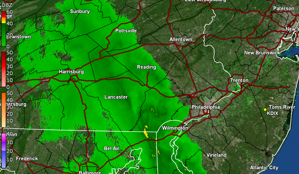
-
E PA/NJ/DE Spring 2024 OBS/Discussion
Hurricane Agnes replied to Hurricane Agnes's topic in Philadelphia Region
And the opener was postponed. And I remember a certain World Series game years ago when the rain was just coming down like crazy. Well I was able to get out early this afternoon, take care of an appointment, get air in one of my tires, and get home just as it started spritzing. Getting heavier showers now. Past couple days of highs/lows were 52/32 & 58/36. This morning's low was a milder 42 and made it up to 49 before the rain started. Currently 46 with light rain, dp 44, and 0.09" in the bucket at post time. -
E PA/NJ/DE Spring 2024 OBS/Discussion
Hurricane Agnes replied to Hurricane Agnes's topic in Philadelphia Region
And the winds have arrived here. Literally has the house creaking and groaning. Temp down to 36 with dp 30. -
E PA/NJ/DE Spring 2024 OBS/Discussion
Hurricane Agnes replied to Hurricane Agnes's topic in Philadelphia Region
Had one more bucket tip to finish up with 3.24" and the sun popped out within the past hour. Made it up to 47 for a high but the temp and dp are dropping quickly. Currently partly sunny and 41 with dp 37. -
E PA/NJ/DE Spring 2024 OBS/Discussion
Hurricane Agnes replied to Hurricane Agnes's topic in Philadelphia Region
The back edge is pivoting away and I'm currently at 3.23" in the bucket. Temp is currently 46 with dp 46. -
E PA/NJ/DE Spring 2024 OBS/Discussion
Hurricane Agnes replied to Hurricane Agnes's topic in Philadelphia Region
I had been following the Climatology section on this for the CWA - I crossed over the 3" mark within the past 30 minutes and am currently sitting at 3.04" in the bucket. The heaviest rates were upwards of about 3/4" an hour so far today. Currently 45 with moderate rain and dp 45. -
E PA/NJ/DE Spring 2024 OBS/Discussion
Hurricane Agnes replied to Hurricane Agnes's topic in Philadelphia Region
When I heard about this on the news, I was thinking of folks in this forum and whether any were near that. Just sad. Past couple mornings here have had lows at or below hard freeze temps. I.e., high/lows for Thurs. & Fri. were 42/28 & 46/27. The dry air with dps down in the teens earlier in the week seemed to help the radiational cooling. There have been a lot of saucer magnolias around here that have been in full bloom although now just past peak, so some of those got hit with petal damage along with some of the early cherries (also past peak). The daffodils that have been blooming in the area didn't get phased by it, as they are pretty tough. Currently have light - moderate rain (0.40" in the bucket at post time), with a low of 39 that happened about 1:30 this morning. Temp has crept up to 42 with dp 42. -
E PA/NJ/DE Spring 2024 OBS/Discussion
Hurricane Agnes replied to Hurricane Agnes's topic in Philadelphia Region
https://www.cpc.ncep.noaa.gov/products/analysis_monitoring/enso_advisory/ensodisc.shtml ENSO advisory notes a "La Nina Watch". Expectations to go ENSO neutral starting in April through to June and then La Nina reappearing over the summer. Will have to see if that pans out. Ended up with a high of 76 yesterday after a 47 low and it's currently a mild 56 with dp 47. -
E PA/NJ/DE Spring 2024 OBS/Discussion
Hurricane Agnes replied to Hurricane Agnes's topic in Philadelphia Region
LOL I remember as a senior in high school back in '79, my high school Physics class took a trip there while it was under construction (the cooling towers were just being built). The PECO tour guide told us that when it was completed, our electric bills would be reduced to $3 a month! Anyway, it was a gorgeous day today with daffodils in bloom and even some cherry trees. I ended up with a high/low of 66/37 yesterday, and 71/41 today. My last 70+ temp was Oct. 27 of last year. Currently 56 with dp 38. -
E PA/NJ/DE Spring 2024 OBS/Discussion
Hurricane Agnes replied to Hurricane Agnes's topic in Philadelphia Region
Under a light flurry shower. Temp at 39 with dp 30.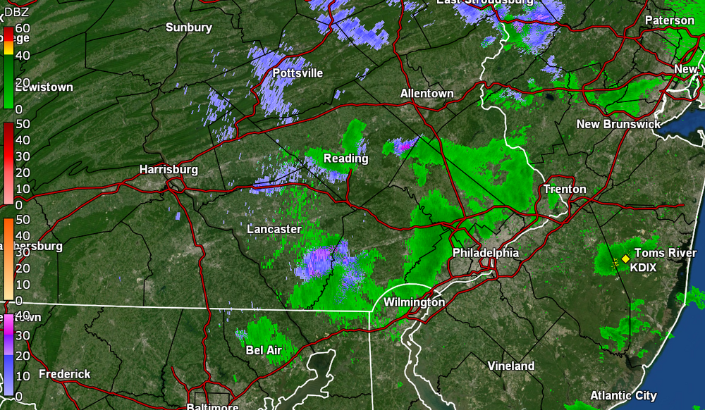
-
E PA/NJ/DE Spring 2024 OBS/Discussion
Hurricane Agnes replied to Hurricane Agnes's topic in Philadelphia Region
Actually gave me a 0.1" dusting of graupel and rimed flakes. Sun peaking out with some leftover flurries. ETA temp down to 36 with dp 32..