Hurricane Agnes
-
Posts
9,335 -
Joined
Content Type
Profiles
Blogs
Forums
American Weather
Media Demo
Store
Gallery
Everything posted by Hurricane Agnes
-
E PA/NJ/DE Summer 2026 Obs/Discussion
Hurricane Agnes replied to PhiEaglesfan712's topic in Philadelphia Region
Under a red blob but just getting tupjca thunderstorm rain. My sister whose flight to FL was already 90 minutes late (due to overbooking), finally got off the ground about 45 minutes ago as the storm cells were approaching. Currently have 0.06"with temp 75, dp 73. -
E PA/NJ/DE Summer 2026 Obs/Discussion
Hurricane Agnes replied to PhiEaglesfan712's topic in Philadelphia Region
Finished up with 0.40" yesterday (the heaviest missed me mostly to the south). That brought my July total to 3.81" so far. Topped out at 80 after a 69 low yesterday. Currently 72 (my low so far) with dp 71. As a sidenote, I heard Ray on KYW this morning. -
E PA/NJ/DE Summer 2026 Obs/Discussion
Hurricane Agnes replied to PhiEaglesfan712's topic in Philadelphia Region
Got up to 85 for a high after a 65 low. Started out nice but the dp has crept back into the 70s. Currently 79 with dp 70. -
E PA/NJ/DE Summer 2026 Obs/Discussion
Hurricane Agnes replied to PhiEaglesfan712's topic in Philadelphia Region
Glad for the heat break today. Only made it to 75 for a high after a low of 65. Also managed to get 0.02" between 1am - 2 am (event total now 3.09"). Currently 73 with dp 68. -
E PA/NJ/DE Summer 2026 Obs/Discussion
Hurricane Agnes replied to PhiEaglesfan712's topic in Philadelphia Region
Well ended up wit another 0.42" for today, raising the total to 1.43". 2-day Is 3.07". Got up to 79 for a high and am currently at my low of 68. -
E PA/NJ/DE Summer 2026 Obs/Discussion
Hurricane Agnes replied to PhiEaglesfan712's topic in Philadelphia Region
Under a blob (with convection and some thunder) that gave me another 0.66" since my last tally, so have 1.01" for the day and 2.65" for 2 days. Temp, dp are 72/72. -
E PA/NJ/DE Summer 2026 Obs/Discussion
Hurricane Agnes replied to PhiEaglesfan712's topic in Philadelphia Region
Ended up with another 0.77" before midnight and 0.33" after for a 2-day total of 1.97". Heard the EAS last night. As I was posting, got another couple hundredths for 1.99". Bottomed out at 71 and currently overcast and 73 with dp 72. -
E PA/NJ/DE Summer 2026 Obs/Discussion
Hurricane Agnes replied to PhiEaglesfan712's topic in Philadelphia Region
So far with that spontaneous cell, I picked up 0.87". There is another blob out west although I don't know if it will hold together if it encounters more stable air. Currently 73 with dp 73. -
E PA/NJ/DE Summer 2026 Obs/Discussion
Hurricane Agnes replied to PhiEaglesfan712's topic in Philadelphia Region
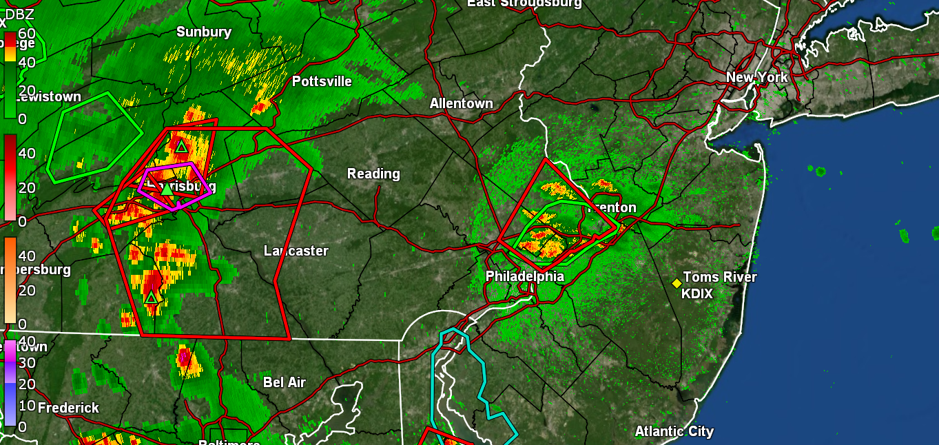
Have a cell spontaneously form over me. Getting over 2"/hr rates. have 0.42" in bucket. Temp 75, dp 73.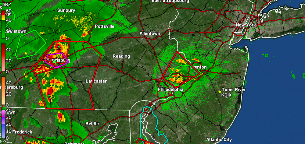
-
E PA/NJ/DE Summer 2026 Obs/Discussion
Hurricane Agnes replied to PhiEaglesfan712's topic in Philadelphia Region
TS watches up (and there is a TOR NW of Harrisburg) - I actually made it to 91 for a high and am currently at 85 with dp 75. -
E PA/NJ/DE Summer 2026 Obs/Discussion
Hurricane Agnes replied to PhiEaglesfan712's topic in Philadelphia Region
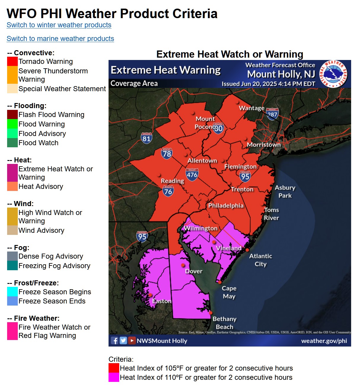
PECO workers are striking. The criteria uses the heat index and duration of the heat event (and the dews have been horrible the past couple days, although at least not in the 80s yesterday or today like last week).
-
E PA/NJ/DE Summer 2026 Obs/Discussion
Hurricane Agnes replied to PhiEaglesfan712's topic in Philadelphia Region
Ended up with 0.32" of rain which I guess is better than nothing but am hoping for more the next couple of days to get all this heat-storing infrastructure cooled down. Looks like I bottomed out at 72 and it's currently overcast and 73 with dp 72. -
E PA/NJ/DE Summer 2026 Obs/Discussion
Hurricane Agnes replied to PhiEaglesfan712's topic in Philadelphia Region
Finally getting some heavier rain. Have 0.15" in the bucket and temp is down to 73. -
E PA/NJ/DE Summer 2026 Obs/Discussion
Hurricane Agnes replied to PhiEaglesfan712's topic in Philadelphia Region
Rocking and rolling here but no measurable rain yet. Gust front came through and knocked the temp down to 81, dp is 74. -
E PA/NJ/DE Summer 2026 Obs/Discussion
Hurricane Agnes replied to PhiEaglesfan712's topic in Philadelphia Region
Fell short of 100 and just touched 99.0 around 3:30 pm. The incoming blob seems to be falling apart but hope to get some rain to cool the brick, cement, and asphalt! Currently 90 with dp 75 and lots of nearby convection , -
E PA/NJ/DE Summer 2026 Obs/Discussion
Hurricane Agnes replied to PhiEaglesfan712's topic in Philadelphia Region
The outflow boundary from those storms gave me no rain and only slowly dropped the temp. But did knock the dews down almost 10 degrees. Bottomed out at 78 this morning (same as Thursday) and it's currently 92 with dp 71 (instead of 81)! -
E PA/NJ/DE Summer 2026 Obs/Discussion
Hurricane Agnes replied to PhiEaglesfan712's topic in Philadelphia Region
Looks like an outflow boundary over me bout other than radar and lots of convection registering on my lighting detector, no temp drops or rain yet - BUT got a 10 degree dp drop. Moet is missing me to the east. Currently 90, dp 69. -
E PA/NJ/DE Summer 2026 Obs/Discussion
Hurricane Agnes replied to PhiEaglesfan712's topic in Philadelphia Region
Well so far I hit 99.5 so will round up to 100. Right now I,'m at 97 with dp 80. Back in 1992, I took a trip to Egypt (which included a multi-day Nile cruise.) This was near the end of July and our final destination before flying back to Cairo, was Abu Simbel, which is about 20 miles north of Sudan. So we are talking the Sahara desert. Temp was 125F. The difference was that the humidity was typically 10% or so (it's more humid around Cairo). That was brutal though and was like your skin was burning. A bunch of folks in our group got heat sickness, but at least it didn't have the humidity like this! -
E PA/NJ/DE Summer 2026 Obs/Discussion
Hurricane Agnes replied to PhiEaglesfan712's topic in Philadelphia Region
Have banged 99 but no triple digits here yet. Norman has the Watches up - -
E PA/NJ/DE Summer 2026 Obs/Discussion
Hurricane Agnes replied to PhiEaglesfan712's topic in Philadelphia Region
I'm at 98 for my high so far (also current), with dp 80. -
E PA/NJ/DE Summer 2026 Obs/Discussion
Hurricane Agnes replied to PhiEaglesfan712's topic in Philadelphia Region
My high was officially 100.0" yesterday at 2:41 pm after a 78 low at 5:44 am. Today a whole other story with an 82 low just before 6 am. I was already at 92 before 9 am. It's currently 97 with a dp of 82 (feels like of 122). -
E PA/NJ/DE Summer 2026 Obs/Discussion
Hurricane Agnes replied to PhiEaglesfan712's topic in Philadelphia Region
My dentist had season tickets and gave me a pair for a 4 pm mid-July 2001 Phillies/Yankees interleague game at the Vet. His seats were literally on the 3rd row to the right of home plate. The weather was perfect that day - warm and no humidity - truly lucked out with that. Had to leave "early" when the game went to extra innings since it was during a weekday. Just hit 100 IMBY. -
E PA/NJ/DE Summer 2026 Obs/Discussion
Hurricane Agnes replied to PhiEaglesfan712's topic in Philadelphia Region
Fake artificial grass. That's why there was so much slipping and sliding on it when wet, often causing some nasty injuries. And other suspected bad outcomes for some Phillies too - https://www.fox29.com/news/investigative-report-dangerous-chemicals-pfas-veterans-stadium-turf The Linc & CBP have the real thing! On the weather front, I hit 99. will see if I get to triple digits later this afternoon . -
E PA/NJ/DE Summer 2026 Obs/Discussion
Hurricane Agnes replied to PhiEaglesfan712's topic in Philadelphia Region
And that wasn't even "real turf", it was "astroturf"! -
E PA/NJ/DE Summer 2026 Obs/Discussion
Hurricane Agnes replied to PhiEaglesfan712's topic in Philadelphia Region
Here it is just after noon and I am at 97 with dp still 80. The Ambient station's "Feels like" is 118.