Hurricane Agnes
-
Posts
9,336 -
Joined
Content Type
Profiles
Blogs
Forums
American Weather
Media Demo
Store
Gallery
Everything posted by Hurricane Agnes
-
E PA/NJ/DE Spring 2026 Obs/Discussion
Hurricane Agnes replied to PhiEaglesfan712's topic in Philadelphia Region
Have been calculating my totals from this long duration event and so far - 5/20 - 0.81" 5/21 - 0.31" 5/22 - 0.05" 5/23 - 0.74" 5/24 - 1.40" 5-day TOTAL = 3.31" (Month to date = 4.41") Today was the heaviest so far, pretty much a month's worth these last 5 days that was needed for a good soaking after that heat! Bottomed out at 50 and made it to 59 for a high. currently overcast and 58 with dp 57. -
E PA/NJ/DE Spring 2026 Obs/Discussion
Hurricane Agnes replied to PhiEaglesfan712's topic in Philadelphia Region
I was finally able to register my non-diurnal temps for yesterday which were a 67 high at midnight and a 54 low just after 11:30 am. Picked up 0.31" of rain yesterday for a 2-day event total of 1.12". My high and low today ended up almost being the same (so far) and as the precipitation shield has drifted north (where there was no precip until later this afternoon), I have picked up 0.05" so far for a 3-day of 1.17". It's currently 53 (my low so far) and overcast/misty, with dp 50. -
E PA/NJ/DE Spring 2026 Obs/Discussion
Hurricane Agnes replied to PhiEaglesfan712's topic in Philadelphia Region
Finished up yesterday's round of rain at a much-needed 0.81". My temps are still dropping this morning so may not have hit my low yet, but am currently an overcast 57 with dp 50. More rain appears to be slowly moving in from the west. -
E PA/NJ/DE Spring 2026 Obs/Discussion
Hurricane Agnes replied to PhiEaglesfan712's topic in Philadelphia Region
My lightning detector has picked up literally hundreds and hundreds of strikes (am guessing mostly cloud-to-cloud) but I haven't seen any obvious flashes and finally heard one weak thunder seemingly from a distance, about 10 minutes ago. Temp has been knocked down to 70 (dp 69) and have 0.61" in the bucket with light rain. -
E PA/NJ/DE Spring 2026 Obs/Discussion
Hurricane Agnes replied to PhiEaglesfan712's topic in Philadelphia Region
AHHHHHHHH. RAIN! Am under a small cell and it dropped my temp from 90 down to 72. Have 0.51" in the bucket at post time. -
E PA/NJ/DE Spring 2026 Obs/Discussion
Hurricane Agnes replied to PhiEaglesfan712's topic in Philadelphia Region
I had nothing measurable but if it did something after I went to bed to wet the walks, it was evaporated by early this morning! SPC in Norman is up with the Severe Thunderstorm Watches - -
E PA/NJ/DE Spring 2026 Obs/Discussion
Hurricane Agnes replied to PhiEaglesfan712's topic in Philadelphia Region
Well the diffused blob was so diffuse that I got nothing from it other than more humidity. I bottomed out at 70 this morning and it's currently 86 with a dp of 70 (which should be banned anytime before July). I did see the upcoming forecast for rain on and off into the weekend so hopefully I get something from that (looks like an overrunning event along the cold front). -
E PA/NJ/DE Spring 2026 Obs/Discussion
Hurricane Agnes replied to PhiEaglesfan712's topic in Philadelphia Region
I was watching that line (literal west to east) run across your area. Figured you might cash in. There were scattered cells that went north of me but my lightning detector didn't miss that trick. Am hoping the diffused blob moving up from the southwest will give me enough to wet the leaves. High today IMBY ended up being 95 and it's currently 82 with dp 65. -
E PA/NJ/DE Spring 2026 Obs/Discussion
Hurricane Agnes replied to PhiEaglesfan712's topic in Philadelphia Region
After a 67 low yesterday, I hit 95 for a high just before 3 pm. Another scorcher today with my low so far a little with my low of 71 so far about 4 degrees warmer than yesterday. Currently sunny and 72 with dp 69. -
E PA/NJ/DE Spring 2026 Obs/Discussion
Hurricane Agnes replied to PhiEaglesfan712's topic in Philadelphia Region
Heat Advisory hoisted for Philly metro - Seems close to the earliest having one for mid-90s in May! Got up to 88 yesterday after a 62 low and it's currently 67 with dp 63. Only have 1.10" of rain for the month so far and shrubs were already wilting yesterday. -
E PA/NJ/DE Spring 2026 Obs/Discussion
Hurricane Agnes replied to PhiEaglesfan712's topic in Philadelphia Region
Over the weekend down here, one of the popular pick-your-own places in the area- Linvilla Orchards in Media, Delaware County, had announced that they lost 90% of their apple crop and somewhere around 60% - 90% of their peach crop after that last freeze. I know those 2 are probably their biggest fruit products in terms of tree planting, popularity, and sales... although they also have plums, nectarines, cherries, pluots and apricots (that IIRC tend to bloom earlier), plus they have the bush fruits like blueberries and raspberries and viners like strawberries. Still , that was a huge loss for them and illustrates how farmers have to deal with fickle weather. I finished up April with 2.68" of rain and over the past week since May 6, I've had 0.95", the latest with 3 rounds yesterday of 0.28", 0.21", and 0.01" just before midnight, with another 0.01" today just after midnight. I was able to get under a couple of tiny convective cells yesterday that triggered my lightning detector, but didn't produce any audible thunder. Still, it was my first convection of the year! Got up to 78 yesterday after a 48 low and am currently at an overcast 50 with dp 38. -
E PA/NJ/DE Spring 2026 Obs/Discussion
Hurricane Agnes replied to PhiEaglesfan712's topic in Philadelphia Region
Thankfully I picked up 1.02" of rain over the 2-day weekend most of it Saturday night. Had put down some fertilizer hoping I wouldn't jinx it and didn't. More is forecast for the middle of the week. Got up to 70 for a high after a low of 40. Currently a sunny 68 with dp 44. -
E PA/NJ/DE Spring 2026 Obs/Discussion
Hurricane Agnes replied to PhiEaglesfan712's topic in Philadelphia Region
Got a measley 0.10" on Sunday over a long period of time but I guess it was better than nothing. No frozen from it though! I did bottom out at 31 this morning and was trying to remember whether someone called the last freeze "the last of the season". Currently mostly sunny and 52 with dp 27. -
E PA/NJ/DE Spring 2026 Obs/Discussion
Hurricane Agnes replied to PhiEaglesfan712's topic in Philadelphia Region
Hit my first 90 of the calendar year just after 2pm today IMBY. The last time the temp was at or above 90 was back on August 17 with a 92. My current weather station (bought in the summer of 2020), has the highest April temps at 87 (2021), 85 (2022), 86 (2023), 88 (2024), & 81 (2025). My old weather station goes back to 2015 with 79 (2015), 81 (2016), 84 (2017), 82 (2018), 80 (2019), 73 (2020). All I know is that there tends to be some week in April, for the most part, where we get into the 80s (and even upper 80s) for a brief time (usually a couple days), and then it goes back to normal (or below). For anyone living in an apartment complex with cooling-tower supplied AC, you are usually SOL (because those buildings don't usually switch over from heat to AC until around May 15)! Currently partly cloudy and 86 with dp 64. -
E PA/NJ/DE Spring 2026 Obs/Discussion
Hurricane Agnes replied to PhiEaglesfan712's topic in Philadelphia Region
I know KYW heavily reported on that. it's the season in Jersey! CPC (or what is left of it) put out their last La Nina Advisory and has started an El Nino Watch - https://www.cpc.ncep.noaa.gov/products/analysis_monitoring/enso_advisory/ensodisc.shtml There was some historical data compiled for strong El Nino years to show general trends. The data goes back to the late '50s through to 2016 - https://www.ncei.noaa.gov/access/monitoring/dyk/el-nino As an obs, I bottomed out at 42 this morning and am currently a sunny 57 with dp 37. -
E PA/NJ/DE Spring 2026 Obs/Discussion
Hurricane Agnes replied to PhiEaglesfan712's topic in Philadelphia Region
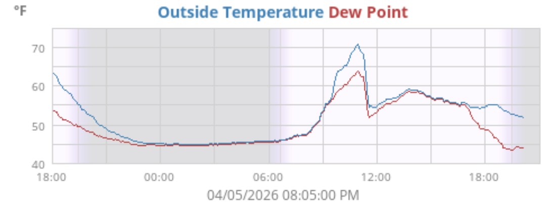
It got up to 71 just before 11 am before the front came through and knocked the reps down about 15 degrees. Ended up with 0.38" in the bucket, but that was over a 5 hour period, so no gully washers. It did get pretty humid around the frontal passage though. Currently 52 with dp 44.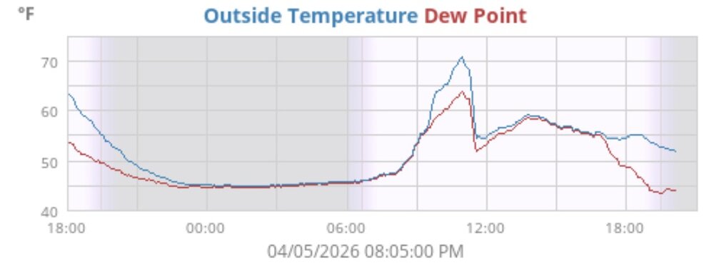
-
E PA/NJ/DE Spring 2026 Obs/Discussion
Hurricane Agnes replied to PhiEaglesfan712's topic in Philadelphia Region
Ended up hitting 80 as a high Tues & Wed. but only got to 60 today (with that temp coming at midnight). Currently a raw and misty 41 with dp 41. -
E PA/NJ/DE Spring 2026 Obs/Discussion
Hurricane Agnes replied to PhiEaglesfan712's topic in Philadelphia Region
Did someone forget to turn off the GFS 10-day snow machine? I bottomed out at 28 this morning (good radiational cooling although I have flowering things budded up) and 30 yesterday morning. They keep threatening about "the heat dome" coming this way but that forecast seems to be jumbled at our latitude. Anyway... currently 46 with 27 dp. -
E PA/NJ/DE Spring 2026 Obs/Discussion
Hurricane Agnes replied to PhiEaglesfan712's topic in Philadelphia Region
Tornado Watch lofted (pretty big expanse now that they added us to the MA folks) - Currently 63 with dp 62. Have 0.61" in the bucket from the earlier round of rain. -
E PA/NJ/DE Spring 2026 Obs/Discussion
Hurricane Agnes replied to PhiEaglesfan712's topic in Philadelphia Region
Back edge is moving through, the sky is brightening, and the sun is trying to come out. Ended up with 0.25" of snow, trace of sleet/ip, and 0.26" of rain/snow/ip melt in the bucket. Anything that had coated or dusted any surfaces, has melted. Currently overcast but clearing and 35, with dp 35. -
E PA/NJ/DE Spring 2026 Obs/Discussion
Hurricane Agnes replied to PhiEaglesfan712's topic in Philadelphia Region
So far got a 0.25" that coated the coldest surfaces (i.e., the car tops), with some dusting of the mulch and grass that quickly melts. But what is on the cars has mostly turned to liquid mush. Currently SN- and 34 with dp 34. -
E PA/NJ/DE Spring 2026 Obs/Discussion
Hurricane Agnes replied to PhiEaglesfan712's topic in Philadelphia Region
After 2 days of highs of 80, I have fatties flying (earlier had some trace pingers). Made it up to 64 as a high before the bottom fell out. Currently SN with little or no stickage, and 35 with dp 33. -
E PA/NJ/DE Spring 2026 Obs/Discussion
Hurricane Agnes replied to PhiEaglesfan712's topic in Philadelphia Region
Even with the "threatening" radar, am only getting some drizzle and graupel (with the latter only barely visible on cold surfaces). Currently 33 with dp 29.
-
E PA/NJ/DE Winter 2025-26 Obs/Discussion
Hurricane Agnes replied to LVblizzard's topic in Philadelphia Region
As a ranking, for the past 20 years posting here on EasternWx/AmWx, this season came in 5th highest. -
E PA/NJ/DE Winter 2025-26 Obs/Discussion
Hurricane Agnes replied to LVblizzard's topic in Philadelphia Region
Looks like my high today will be 56 (which happened just before 3 pm), after a 27 low. This is the warmest day since this past Dec. 19., which hit 57 here. Still have massive plowed mounds around the area that might be here for weeks unless there is sustained warmth and maybe rain. The NE-facing spots still have about an inch or two remaining. In any case, it's a cloudless 55 with dp 39.