Hurricane Agnes
-
Posts
9,346 -
Joined
Content Type
Profiles
Blogs
Forums
American Weather
Media Demo
Store
Gallery
Everything posted by Hurricane Agnes
-
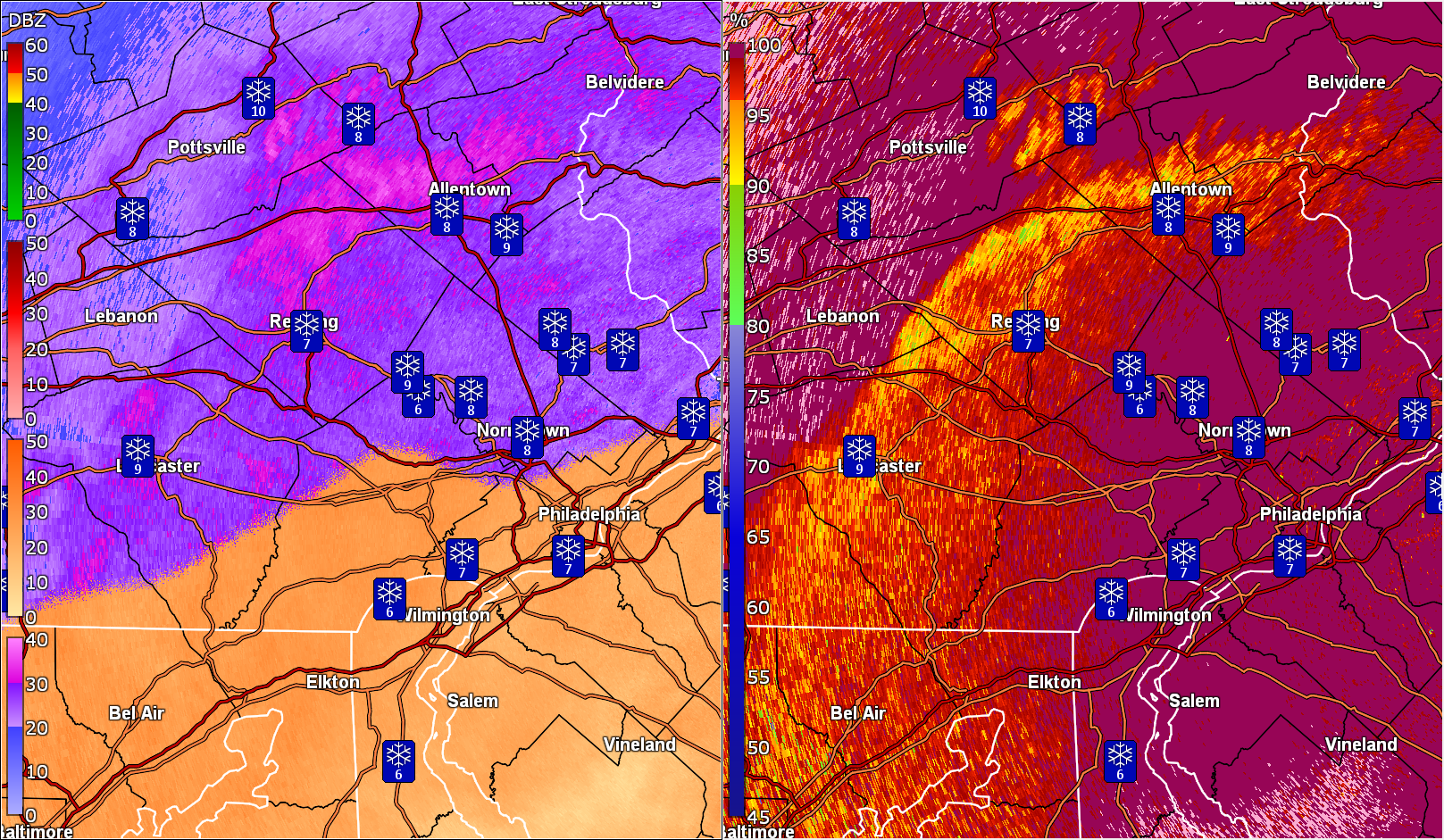
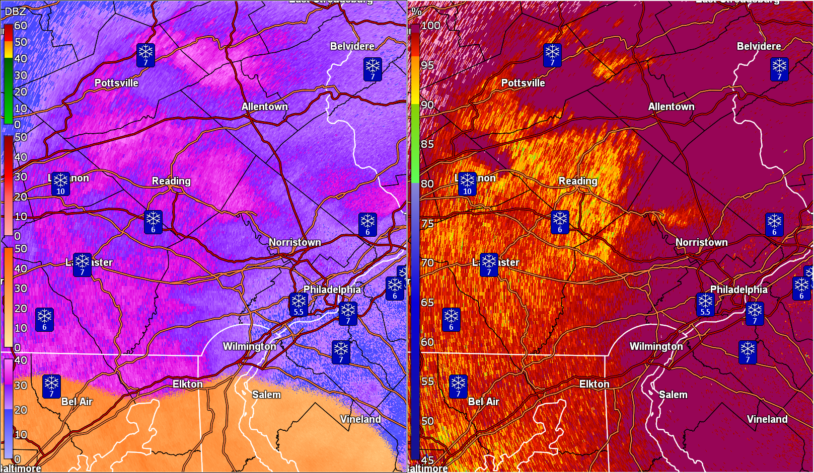
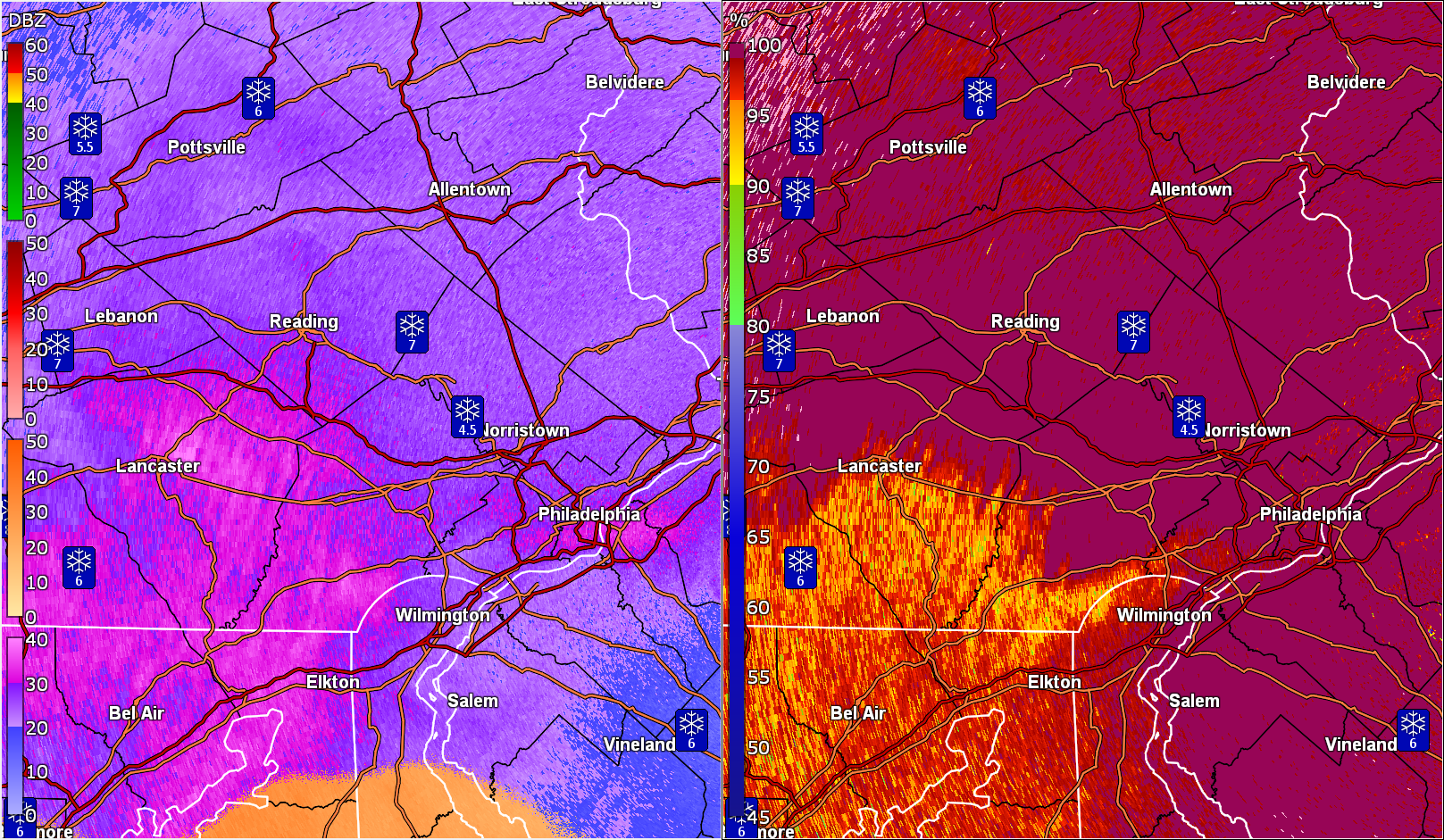
E PA/NJ/DE Winter 2025-26 Obs/Discussion
Hurricane Agnes replied to LVblizzard's topic in Philadelphia Region
I was out around that time finishing up getting the snow off the roof of the car (a SUV) and just as I was about to come in, there were some flurries. Currently overcast and 22 with dp 10. Had a low of 11 and high of 23. (have avoided the midrange model freakout but will try to start checking the runs tomorrow ) -
January 25-26 Winter Storm Potential
Hurricane Agnes replied to Ralph Wiggum's topic in Philadelphia Region
This is the method I used a few years ago. I like these little videos from a series made for CoCoRaHS observers (they go in order for what you need to know and do) - They have some of the series here - https://www.youtube.com/@cocorahs -
January 25-26 Winter Storm Potential
Hurricane Agnes replied to Ralph Wiggum's topic in Philadelphia Region
It took forever to get out back because of the drifted crust up against the back door. Crust BECAUSE this thing came to an end with either ZR and/or FZDZ. Trying to chunk some snow/sleet/ice off the step was a bear... Earlier, the sleet just pushed aside with my "SnoBrum" like the powdery snow but not this time. Confirmed the ZR/FZDZ after seeing accretion of about 0.1" on the bare car surfaces (snow blew off much of anything that was on the car sides) and metal surfaces like metal rails. Ended up with an additional 1.5" of sleet on top of the earlier 1.75" for 3.25" of sleet. That formed a layer on top of the earlier (compacted with some loss from wind) 4.0" of snow for 7.25". Currently a balmy 21 with dp 19. -
January 25-26 Winter Storm Potential
Hurricane Agnes replied to Ralph Wiggum's topic in Philadelphia Region
See that in central PA moving this way and agree about any travel. This will be a bear to clear.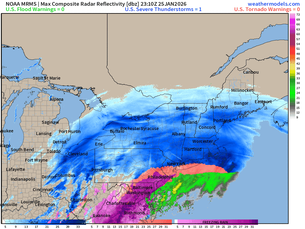
-
January 25-26 Winter Storm Potential
Hurricane Agnes replied to Ralph Wiggum's topic in Philadelphia Region
Still sleeting here and it is piling up. I had to get the shovel to push it away from the door (we have a service that does the lots and walks, etc here but they abandoned ship for now ). Currently 17, which is actually my high for the day so far (after an 11 low), with a dp that has been gradually increasing and now up to 15. -
January 25-26 Winter Storm Potential
Hurricane Agnes replied to Ralph Wiggum's topic in Philadelphia Region
Blowing and drifting. I have over 1 ft drifts and I know that snow blew off the top of accumulation where my board is. When I stepped out on the patio for my 5 pm measurement, I really sunk in and I did do some ruler measurements at other locations on the patio at that time, and was getting anywhere from 7' - 11" at 5 pm (patio is poured concrete but I have a bunch of containers out there too so I really don't have a good flat surface for the board except up on a table. The 4" measurement was done at around 11 am before the switch to sleet that happened just before noon. -
January 25-26 Winter Storm Potential
Hurricane Agnes replied to Ralph Wiggum's topic in Philadelphia Region
The other models weren't showing ip until Sunday and were overdoing the snow thump in the I-95 corridor/city. Paul had posted a NAM sleet map back last Thursday and it was persistent with it. It was just the past day or two when the weather services had to scale back the city numbers. The other models were also discounting the ZR and now you have ZR in south Jersey and moving in to PA. -
January 25-26 Winter Storm Potential
Hurricane Agnes replied to Ralph Wiggum's topic in Philadelphia Region
Did a 5pm measurement and got another 0.75" of sleet and now have a snow/sleet total of 5.75" Still had heavy sleet going at the time but it is like course sand - easy to push and it was easy to clear the board. It keeps drifting up to my back door and now my front door. ZR line looks to be approaching just below the city. Gonna say it again - NAM nailed it.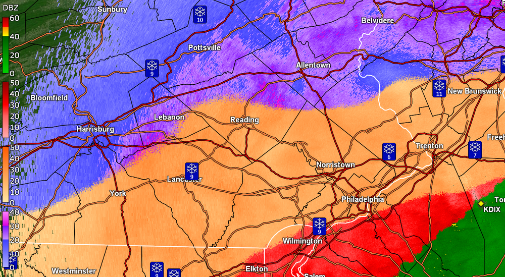
-
January 25-26 Winter Storm Potential
Hurricane Agnes replied to Ralph Wiggum's topic in Philadelphia Region
Have about 80% snow/sleet mix now with temp at 15 and dp 13. Still wondering about that firehose headed this way.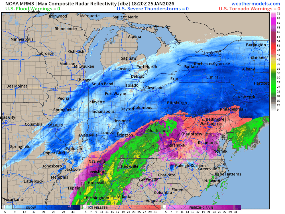
-
January 25-26 Winter Storm Potential
Hurricane Agnes replied to Ralph Wiggum's topic in Philadelphia Region
Just measured the board. Currently puking sleet again and measured 1" of it. That would bring my snow/sleet total to 5". Temp now "up to" 16 with dp 14.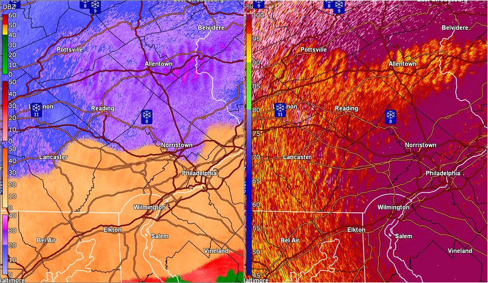
-
January 25-26 Winter Storm Potential
Hurricane Agnes replied to Ralph Wiggum's topic in Philadelphia Region
That may have been what I have been seeing. It was coming down like white rain and not as pingers but apparently didn't last long enough for accretion (so far) and am back to mostly pingers/snow. -
January 25-26 Winter Storm Potential
Hurricane Agnes replied to Ralph Wiggum's topic in Philadelphia Region
Checked and am back to about 50/50 snow/sleet (can definitely hear the pingers again). Not seeing accretion so if there was rain mixed it, it may have been FRDZ. Currently 15 with dp 13. -
January 25-26 Winter Storm Potential
Hurricane Agnes replied to Ralph Wiggum's topic in Philadelphia Region
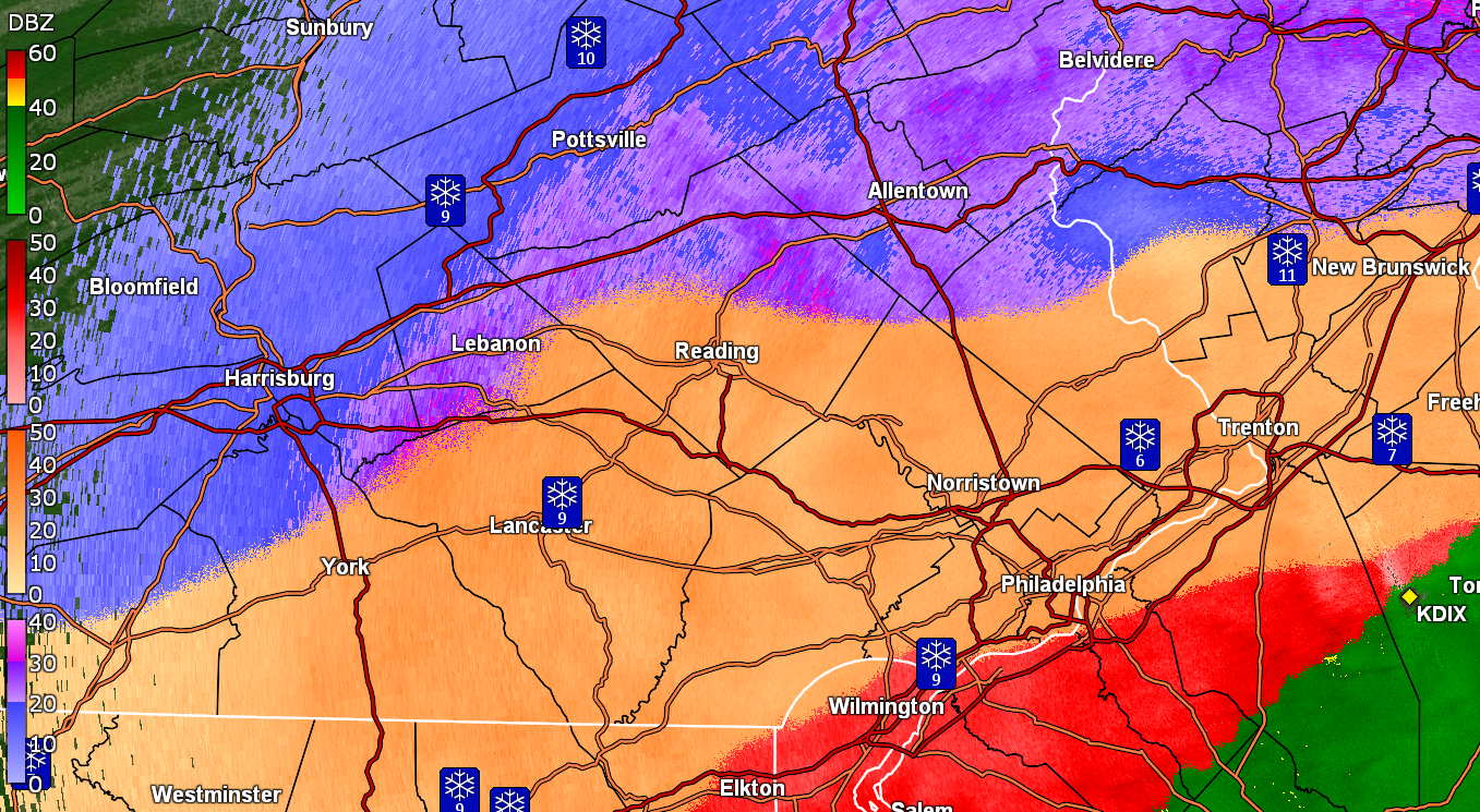
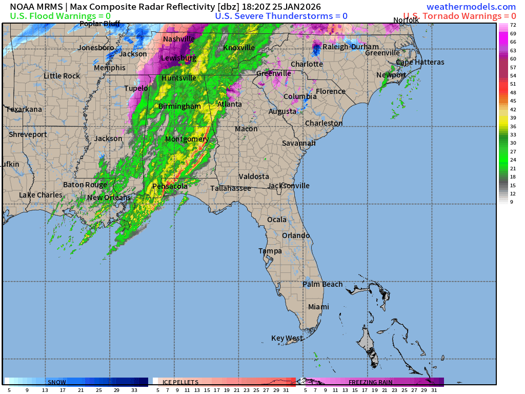
I think the NAM was taking it as a long duration (into Monday) event for whatever frozen ptype was going to fall. Since this is pulling a lot of moisture from the Gulf, it could continue to go for some time as long as it doesn't get blocked too much. Added a map below from the SE and you can see the firehose of warm moisture coming out the Gulf. I have switched back to mostly fine show and hear very little pingers but at the rate the flakes are falling, it *might be* a rain/snow mix.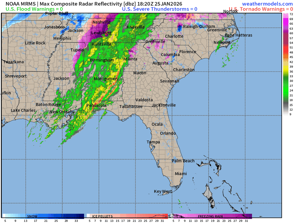
-
January 25-26 Winter Storm Potential
Hurricane Agnes replied to Ralph Wiggum's topic in Philadelphia Region
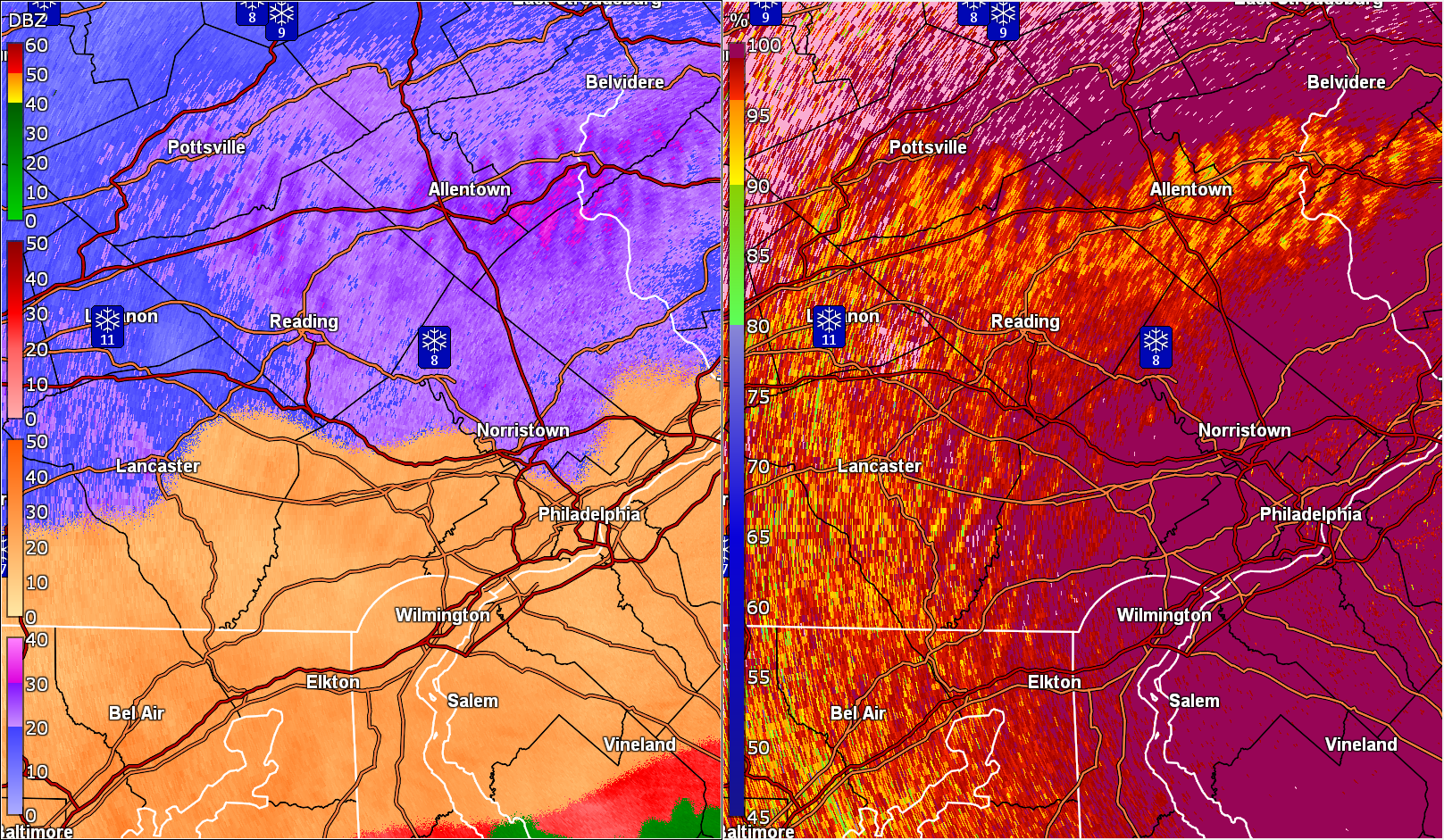
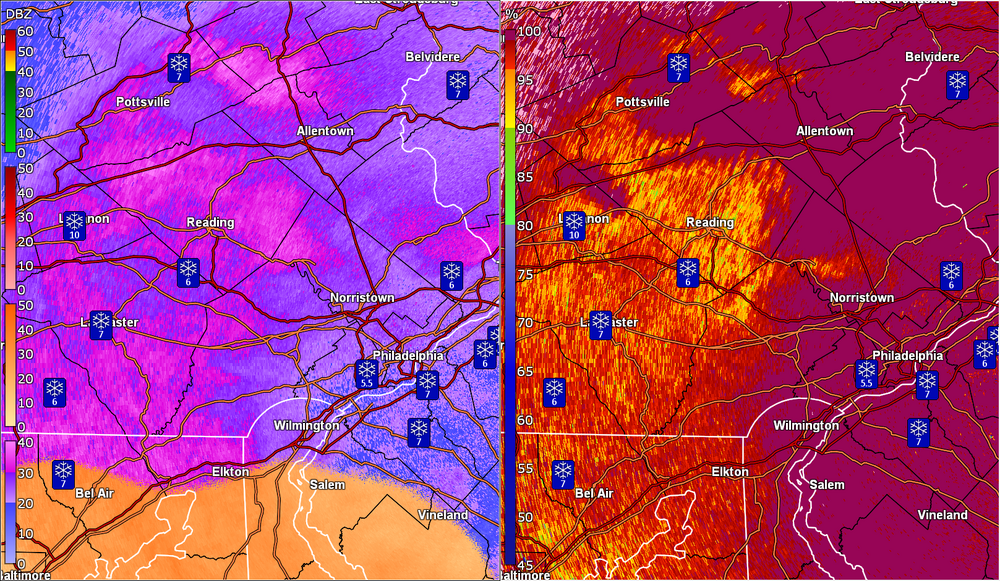
Yeah that depiction is pretty cool and is also capturing the "overrunning" rain of this event that had been forecast early on and now as it moves east, TN is getting some nasty ZR. -
January 25-26 Winter Storm Potential
Hurricane Agnes replied to Ralph Wiggum's topic in Philadelphia Region
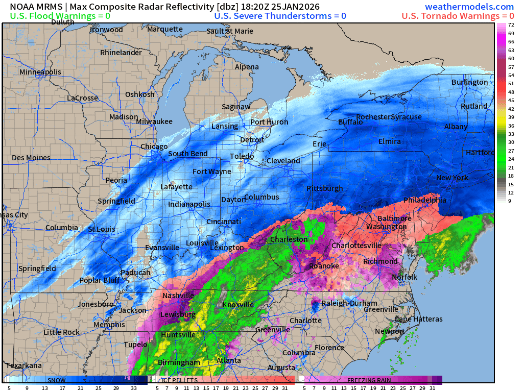
Did some fooling around with the weathermodels.com stuff and found this (it was definitely what the NAM has shown for a couple days in a row) -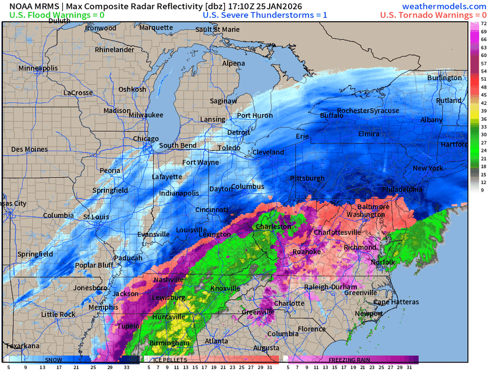
-
January 25-26 Winter Storm Potential
Hurricane Agnes replied to Ralph Wiggum's topic in Philadelphia Region
Have been puking sleet the past half hour, where the earlier mixing was there about 10 minutes ago and is now pure sleet, with some blowing snow mixing in from roof tops. Temp is up to 15 and dp 12. Well that might depend on what that High sitting over Maine does.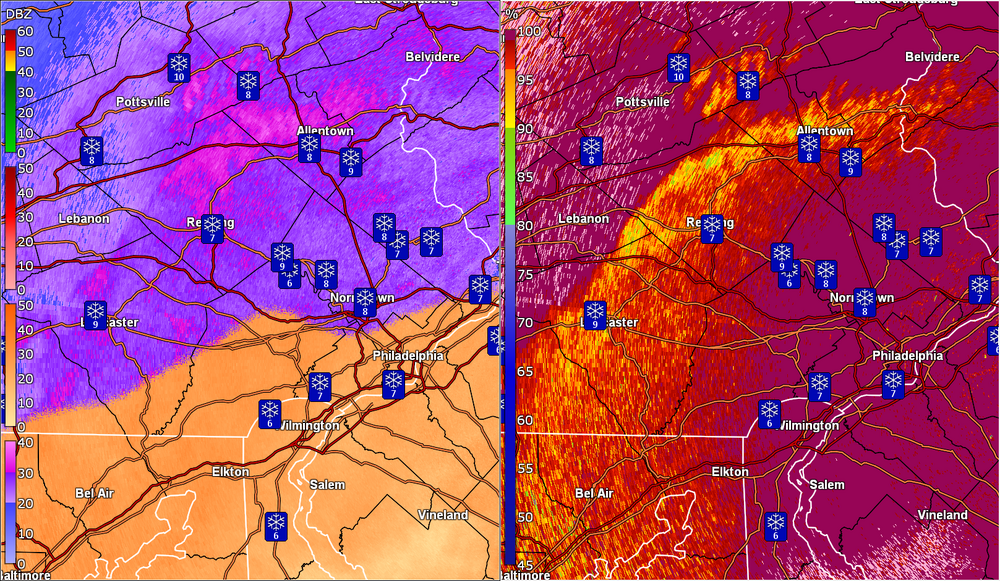
-
January 25-26 Winter Storm Potential
Hurricane Agnes replied to Ralph Wiggum's topic in Philadelphia Region
Am thinking some wrap-around snow finish once the low moves away. It's sitting right near Hampton, VA. There's some real cold air still out there. -
January 25-26 Winter Storm Potential
Hurricane Agnes replied to Ralph Wiggum's topic in Philadelphia Region
Currently have a snow/sleet mix - you can see the flakes and hear the pingers. Temp is currently 13 with dp 11. -
January 25-26 Winter Storm Potential
Hurricane Agnes replied to Ralph Wiggum's topic in Philadelphia Region
-
January 25-26 Winter Storm Potential
Hurricane Agnes replied to Ralph Wiggum's topic in Philadelphia Region
Yup a weekend and it ended the day before my birthday. Did a birthday Jeb Walk (clear and sunny) down the middle of the plowed street along the side of my apartment building, right to the supermarket to get the usual "french toast supplies". There were 6ft plowed mounds on either side of the street with a "path" carved through them near intersections. The NAM had been showing this run after run the past couple days. All bubbling up from the south and brushing the area. Paul even posted some sleet maps. It was showing more ice chances south of here and down that way. I know I was concerned about ZR down there too. Confirmed. Started less than an hour after I cleared the board. -
January 25-26 Winter Storm Potential
Hurricane Agnes replied to Ralph Wiggum's topic in Philadelphia Region
I am getting a lot of blowing and drifting and had a 1ft drift up against the top of my step going down to the patio. I did an 11 am measurement from the board and have 4" so I know I lost some from the drift (my back faces NE). Thankfully it was easy to move it away from the step with my car "SnoBrum" and also clear the board. Currently SN, fog, and 13, with dp 11. It's wild looking at the CC because it is forming that warm wave just like the NAM predicted! I had mentioned how the '96 storm held in the low 20s (IIRC ~23F) through the duration (and this is much colder). I also used to have co-workers from Chicago who used to pooh-pooh our whining about shoveling back then because they could just get a regular broom to brush off the car and use a leaf blower to blow the stuff off the walks. Now 30 years later, they have learned what "wet snow" is like.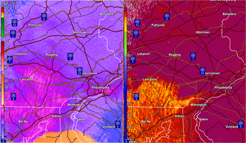
-
January 25-26 Winter Storm Potential
Hurricane Agnes replied to Ralph Wiggum's topic in Philadelphia Region
Wonder if it's an AI test run? Will see what verifies! -
January 25-26 Winter Storm Potential
Hurricane Agnes replied to Ralph Wiggum's topic in Philadelphia Region
I would agree with that. You can always chunk and flick away a top crust and have powder underneath that you could probably use something like a leaf blower to move around. Leaving bare pavement with sleet/ZR means whipping out the ice chopper and some good rock salt or something to make a dent in it and a snowblower would choke on that (they often choke on wet snow as it is). -
January 25-26 Winter Storm Potential
Hurricane Agnes replied to Ralph Wiggum's topic in Philadelphia Region
Just went out and measured and have 2.0" on the nose of literal baby powder snow. The kind that every kid would hate trying to make snowballs or a snowman! It started here around 3 am so just over 4 hours and apparently at around 1/2" per hour. The intensity has picked up some though. Temp is 11 with dp 9, so a rare bitter cold/dry snow - similar to what I recall in 1996 except half the temp (that storm had temps IMBY holding around 23F through much of it)! -
January 25-26 Winter Storm Potential
Hurricane Agnes replied to Ralph Wiggum's topic in Philadelphia Region
Have had SN- to SN the past hour here in NW Philly and it has dusted all but treated surfaces, thanks to a temp of 13 and dp 6. Here we go!