Hurricane Agnes
-
Posts
9,346 -
Joined
Content Type
Profiles
Blogs
Forums
American Weather
Media Demo
Store
Gallery
Everything posted by Hurricane Agnes
-
January 25-26 Winter Storm Potential
Hurricane Agnes replied to Ralph Wiggum's topic in Philadelphia Region
Randy might have found it during that Tug Hill blizzard fest. -
January 25-26 Winter Storm Potential
Hurricane Agnes replied to Ralph Wiggum's topic in Philadelphia Region
AmWx WAS EasternWx until 2010 when they re-did the site. I remember the years of the routine of "changing the snow tires" in spring and fall (on 2 different station wagons over the years in the '60s - late-'70s) and keeping a set of chains in the back of the station wagon. Except for the '66 storm, none of that was really needed. The snow drought literally "broke" the year my mom bought a brand new Mercury Zephyr after getting rid of the old station wagon and then a few months later, having some cop car doing a chase on the snowy street, and T-boneing it while it was parked in front of the house. Thank goodness for "all-weather tires" (at least around these parts - the snow zones in the northern U.S. still have those snow tires as I understand). -
January 25-26 Winter Storm Potential
Hurricane Agnes replied to Ralph Wiggum's topic in Philadelphia Region
I think the blizzard criteria is for sustained 35 mph or greater. Traction! It was also the days of chains and spiked tires. -
January 25-26 Winter Storm Potential
Hurricane Agnes replied to Ralph Wiggum's topic in Philadelphia Region
I don't think "transfer" is in terms of "energy" but in terms of movement. I sometimes say "jumped to the coast" and restrengthened (mainly because when that process is happening, there is that "dry slot" that forms" and what ends up off the coast may be like a remnant of some kind and not a brand new low). -
January 25-26 Winter Storm Potential
Hurricane Agnes replied to Ralph Wiggum's topic in Philadelphia Region
I think they use the brine so that the frozen stuff won't stick to the road as much and it makes it easier to plow it away down to the asphalt. The salt usually comes after the stuff is plowed. I know they have some newer mixes of salt that can go lower but with the kind of cold they are talking about, back in the day you probably remember when they went on and put sand out. -
January 25-26 Winter Storm Potential
Hurricane Agnes replied to Ralph Wiggum's topic in Philadelphia Region
You probably haven't driven downtown when there was a bare coating of packed down rutted snow with a layer of ice and water on top on the major streets, where buses start spinning or slide around when turning a corner! Don't ask me why I would know the issues. -
January 25-26 Winter Storm Potential
Hurricane Agnes replied to Ralph Wiggum's topic in Philadelphia Region
Fairmount is near the Art Museum downtown so there is a warmer microclimate due to the building density down there. I still think this will definitely be a "warning criteria" storm, i.e., >6". -
January 25-26 Winter Storm Potential
Hurricane Agnes replied to Ralph Wiggum's topic in Philadelphia Region
Not so much for ice (sleet/ZR) versus snow though.... Although I remember going on a senior class trip to Tamiment in the Poconos back in '79 in January and there was ZR that weekend with the slopes too slick to ski on and then the temps hit 40, so it was either ice skating in their indoor rink or board games. -
January 25-26 Winter Storm Potential
Hurricane Agnes replied to Ralph Wiggum's topic in Philadelphia Region
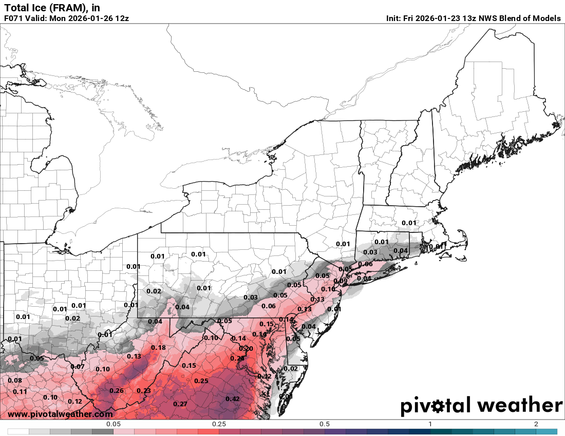
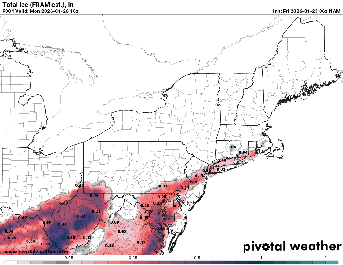
I saw your comment. The whole "transfer to the coast" thing always catches my attention. I had never heard of a "Miller C" but apparently it is a "thing" with La Nina ENSO. The 13z NBM doesn't look good (ice wise).
-
January 25-26 Winter Storm Potential
Hurricane Agnes replied to Ralph Wiggum's topic in Philadelphia Region
Apparently just ZR accumulation. -
January 25-26 Winter Storm Potential
Hurricane Agnes replied to Ralph Wiggum's topic in Philadelphia Region
WSW - -
January 25-26 Winter Storm Potential
Hurricane Agnes replied to Ralph Wiggum's topic in Philadelphia Region
Even though it's not a strict "Miller B", the whole setup feels like a hybrid one with a low riding up a cold front as the front moves east, and then transferring out to the coast. Anything that even hints at "Miller B" seems to always be hard to nail down. -
January 25-26 Winter Storm Potential
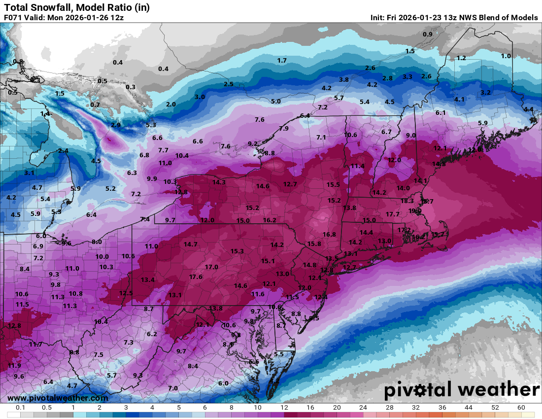
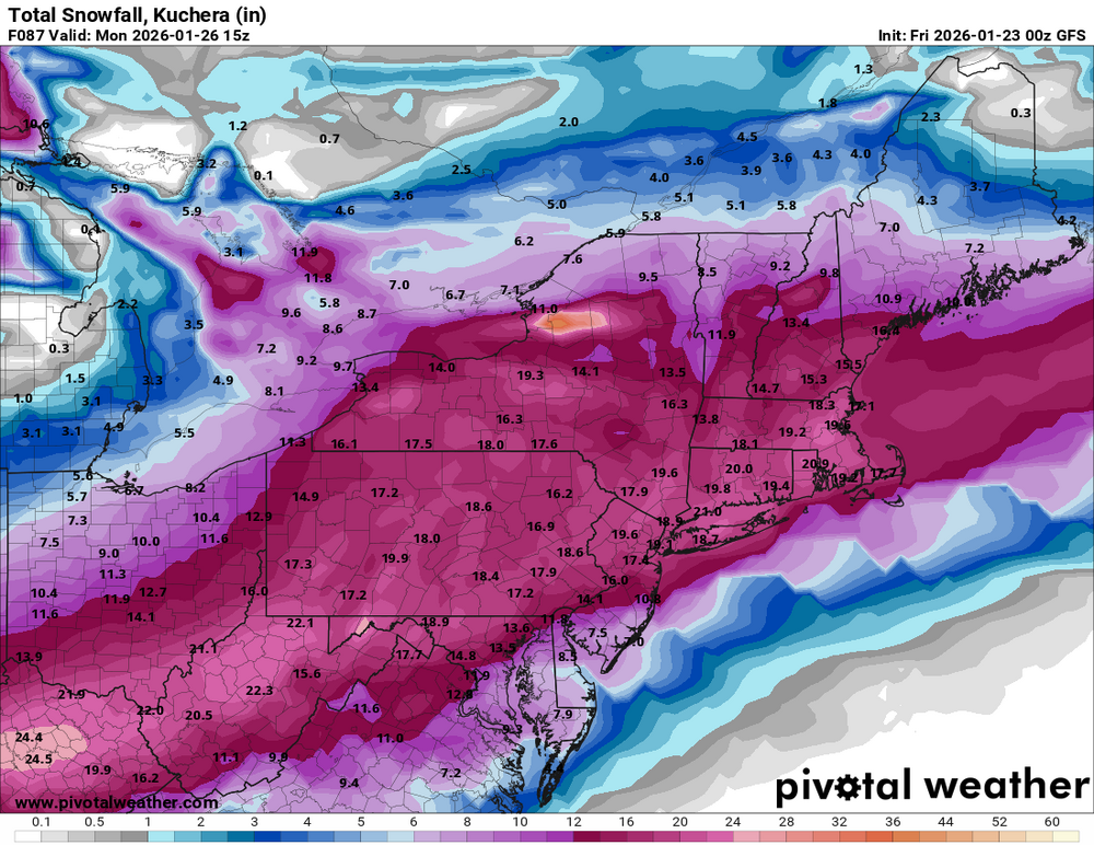
Hurricane Agnes replied to Ralph Wiggum's topic in Philadelphia Region
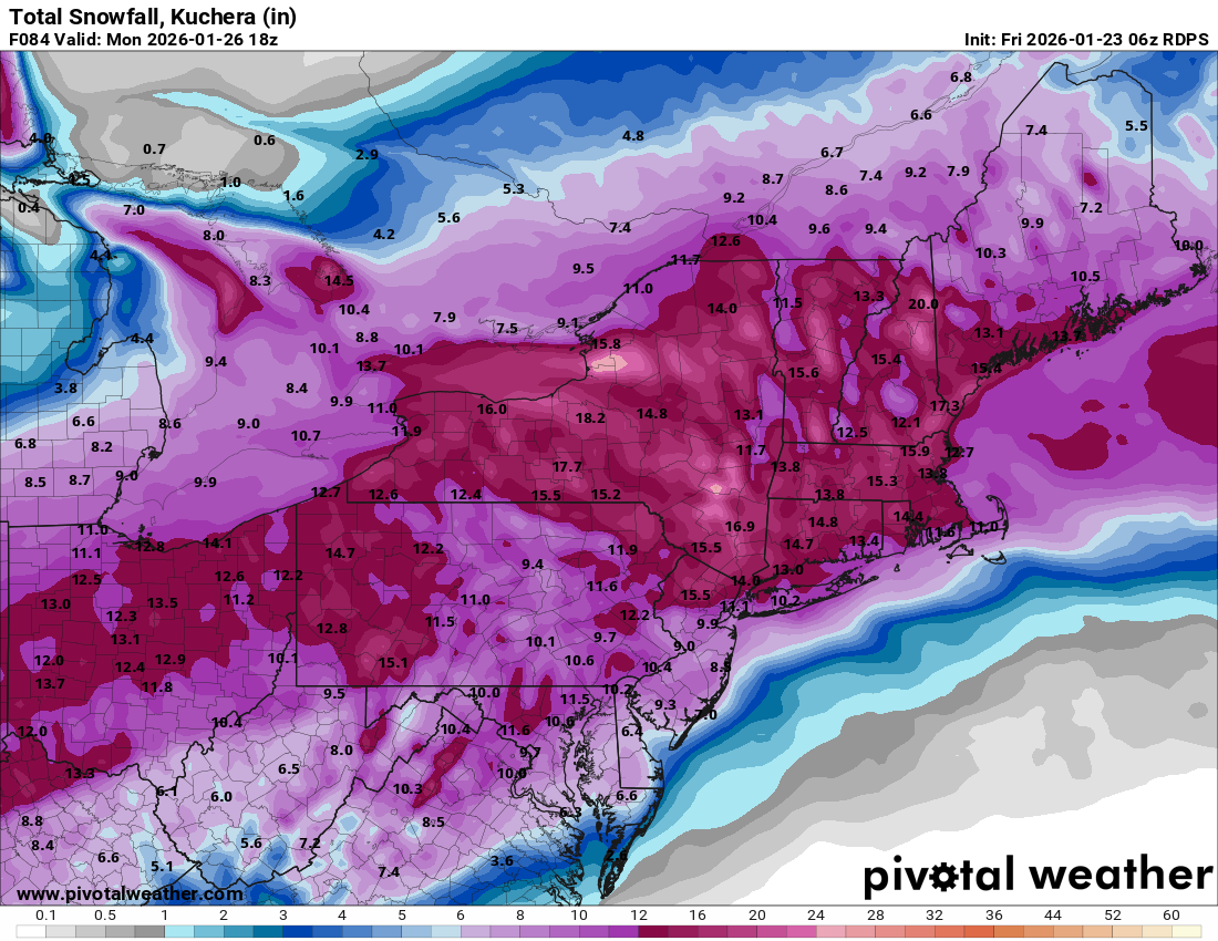
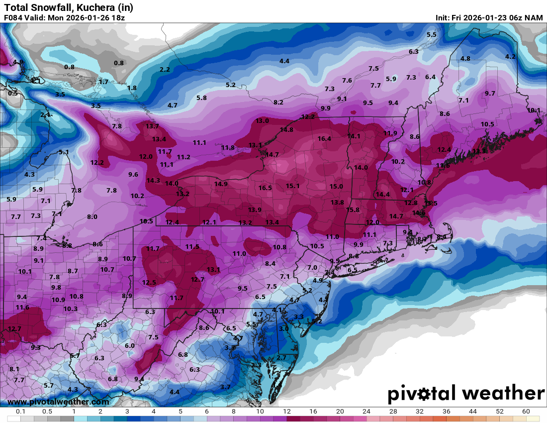
EC 12z Kuchera -


-
January 25-26 Winter Storm Potential
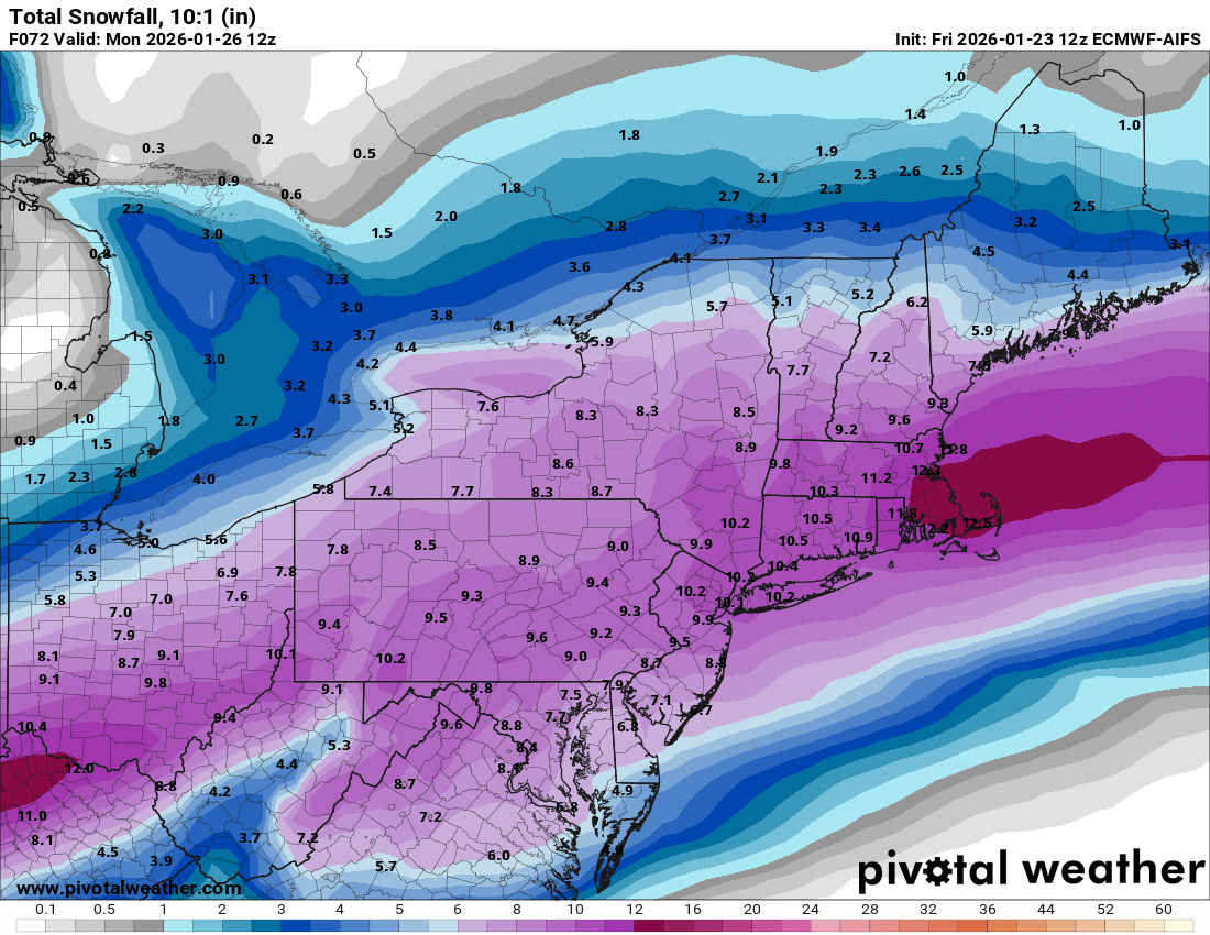
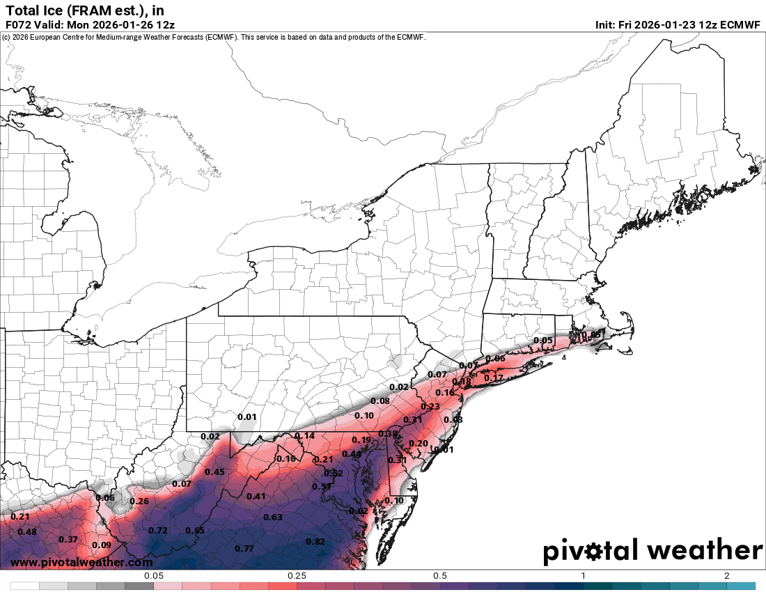
Hurricane Agnes replied to Ralph Wiggum's topic in Philadelphia Region
The AI one doesn't have that option (unless it's just a Pivotal Weather thing). The regular EC is still running. -
January 25-26 Winter Storm Potential
Hurricane Agnes replied to Ralph Wiggum's topic in Philadelphia Region
The AI one looks conservative compared to everything else.
-
January 25-26 Winter Storm Potential
Hurricane Agnes replied to Ralph Wiggum's topic in Philadelphia Region
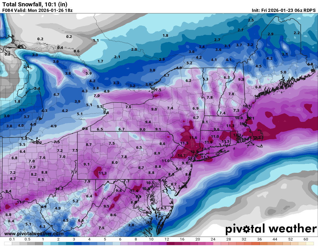
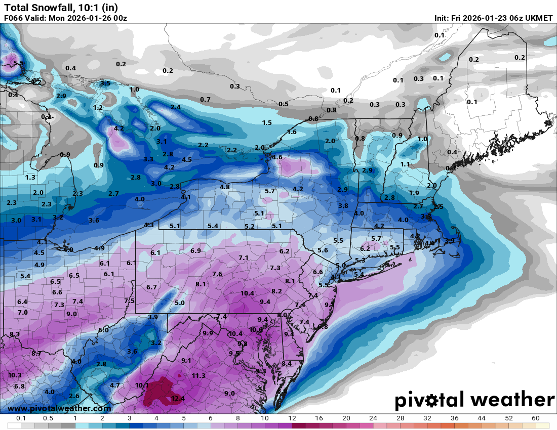
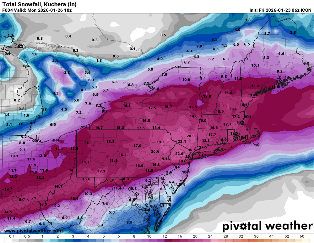
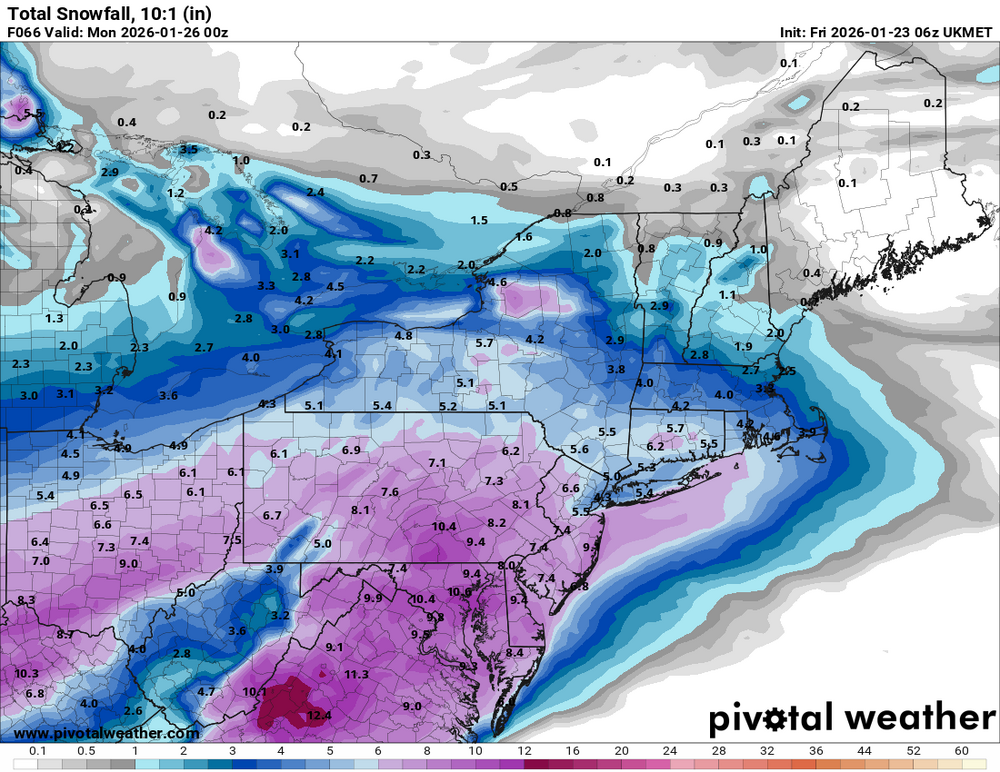
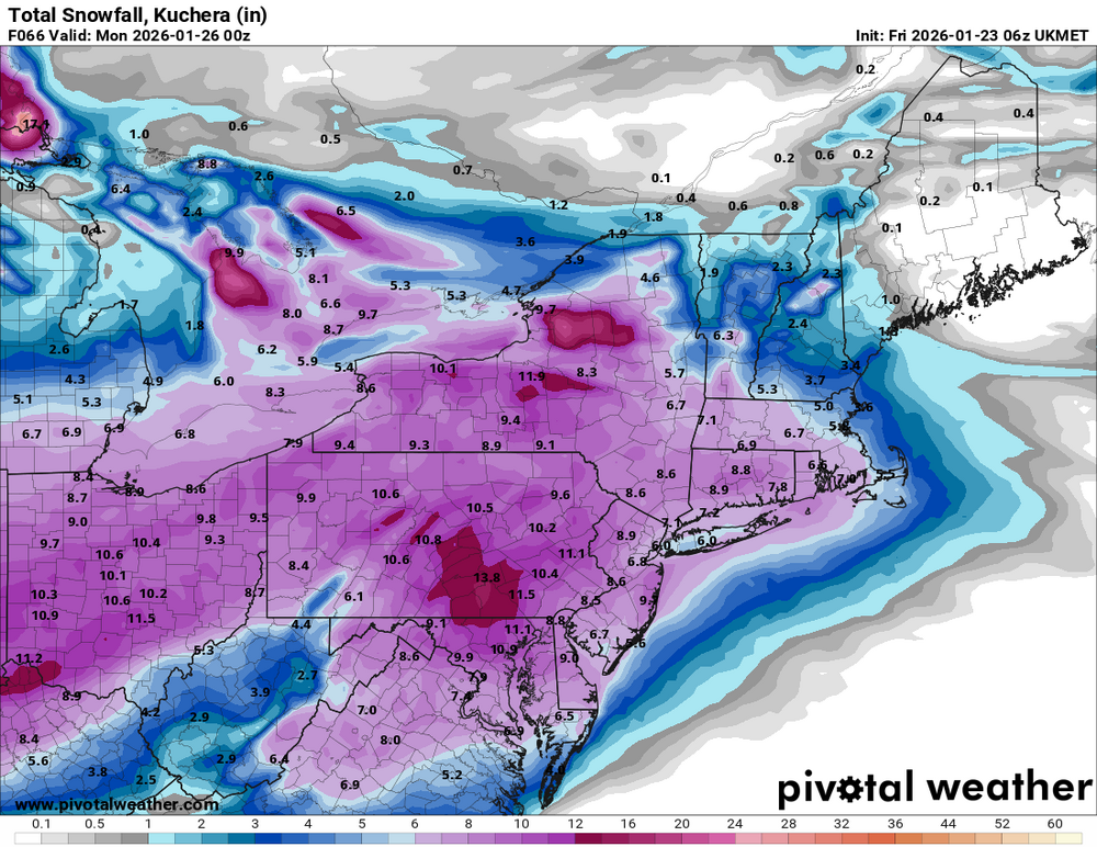
Some other 6zs - ICON, Canadian & Ukie.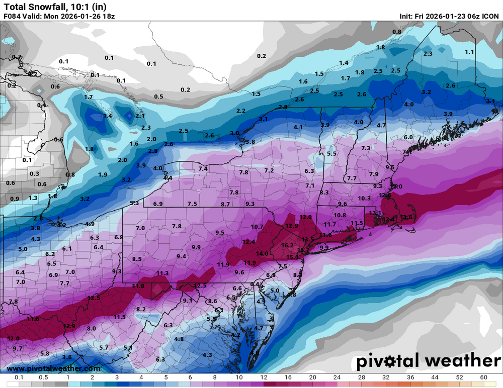


-
January 25-26 Winter Storm Potential
Hurricane Agnes replied to Ralph Wiggum's topic in Philadelphia Region
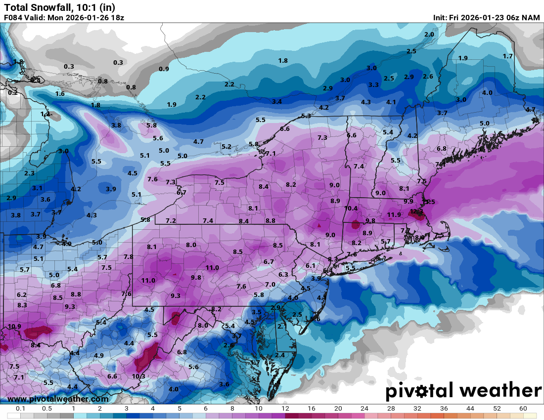
6z 12k NAMs still wants to put other frozen in there.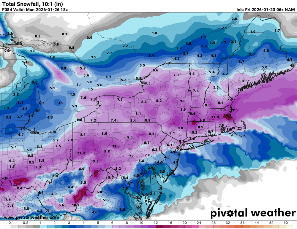


-
January 25-26 Winter Storm Potential
Hurricane Agnes replied to Ralph Wiggum's topic in Philadelphia Region
7z NBM.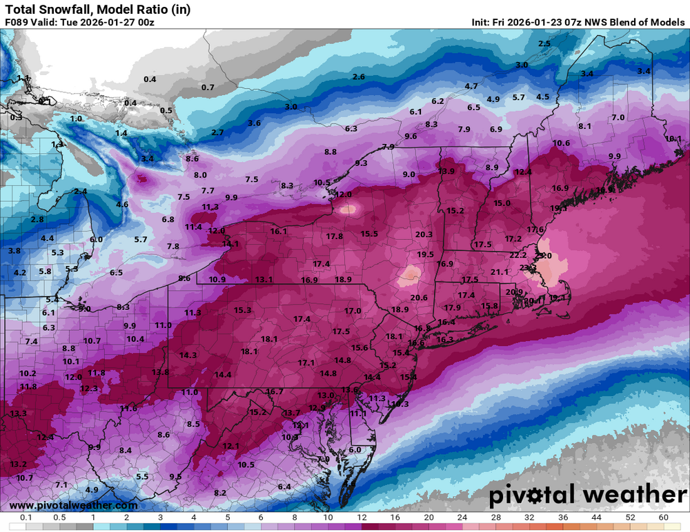
-
January 25-26 Winter Storm Potential
Hurricane Agnes replied to Ralph Wiggum's topic in Philadelphia Region
6z AI EC.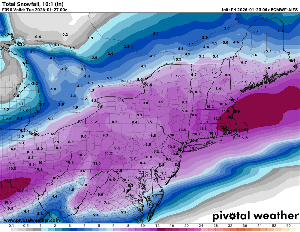
-
January 25-26 Winter Storm Potential
Hurricane Agnes replied to Ralph Wiggum's topic in Philadelphia Region
I know we are really coming into CAMs range but here is the 6z GFS (6z AI ECM is running).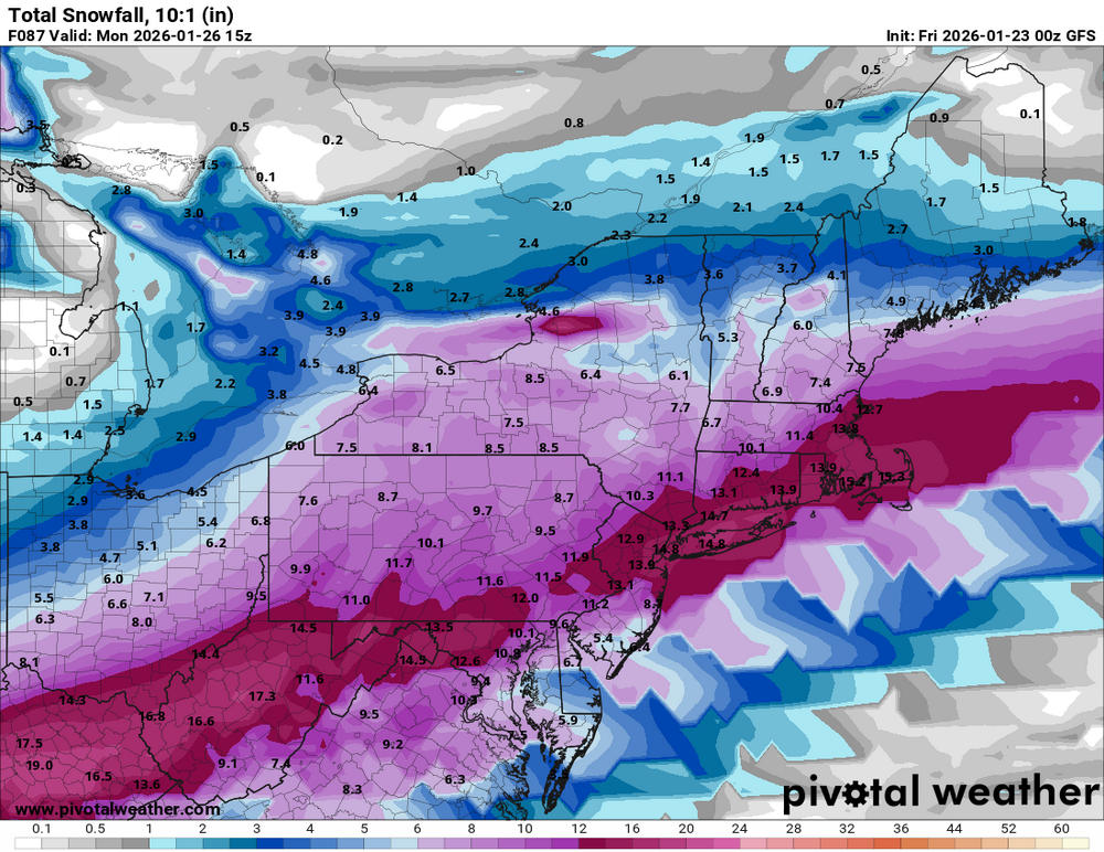
-
January 25-26 Winter Storm Potential
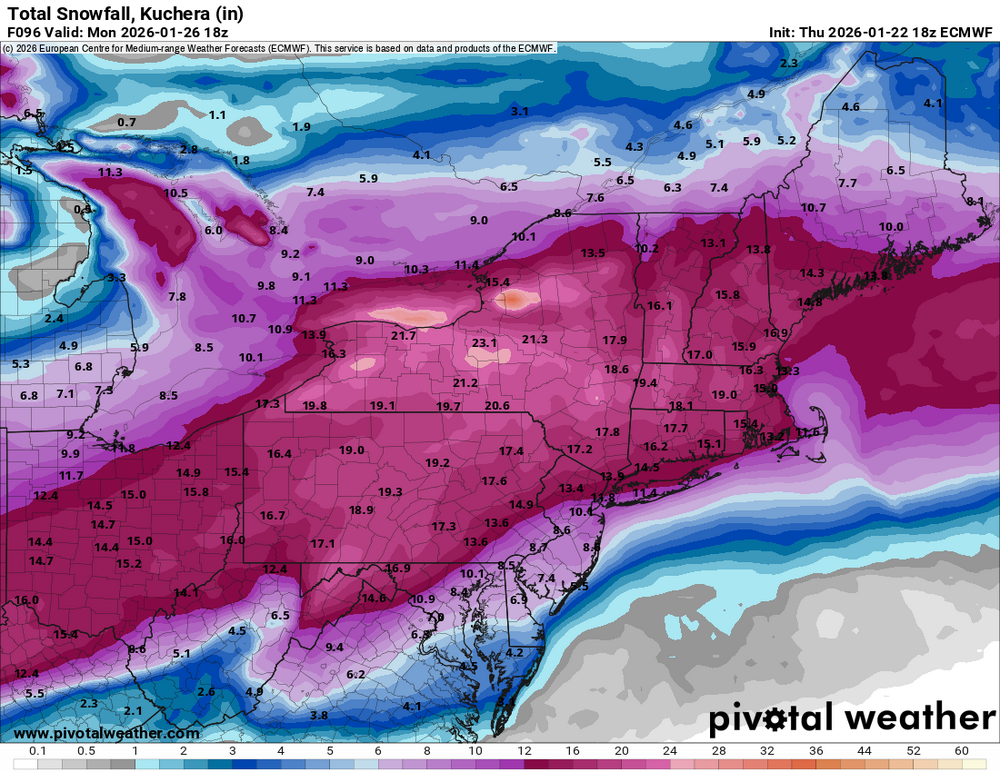
Hurricane Agnes replied to Ralph Wiggum's topic in Philadelphia Region
18z Euros. Still think tomorrow with the 0zs and 12zs will be "go time" (including the NAM) -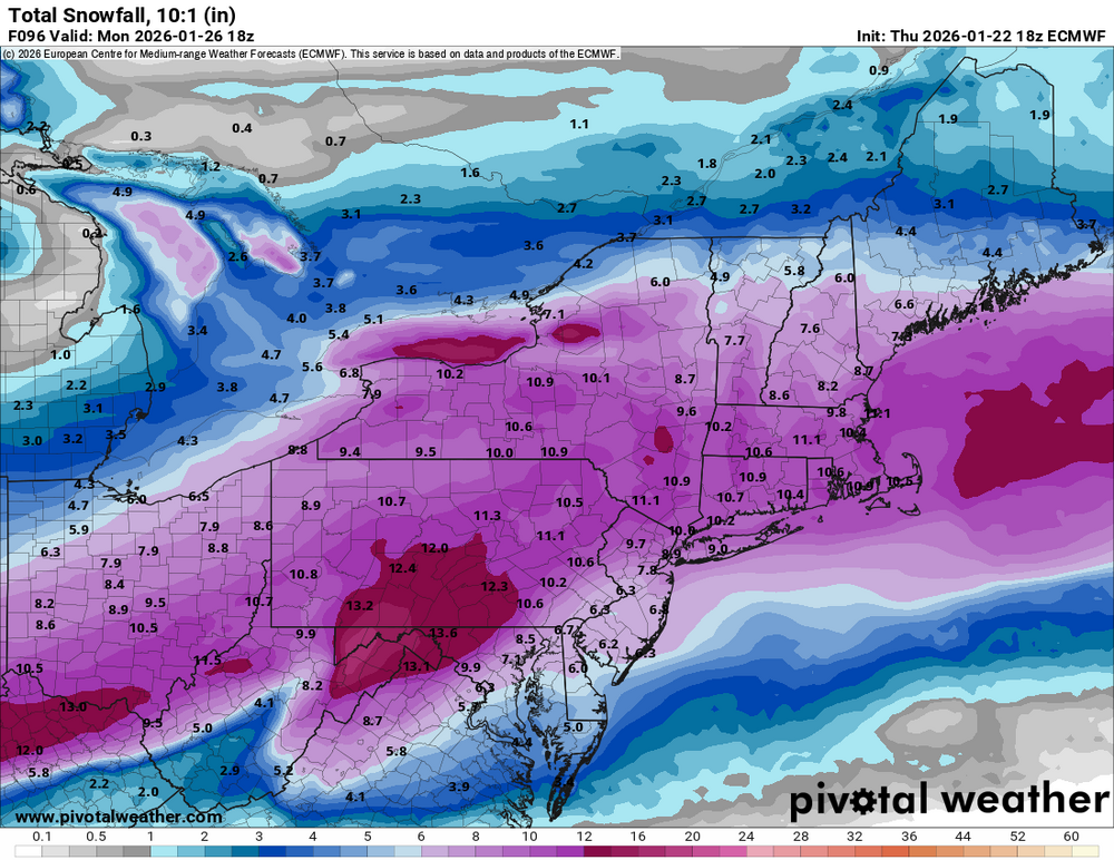
-
January 25-26 Winter Storm Potential
Hurricane Agnes replied to Ralph Wiggum's topic in Philadelphia Region
And so you proceeeded to send me down the rabbit hole to sub to that. I remember when they first came out and were free (for some stuff). But times change... Their 18z GFS 282 hr sleet map - still looks to be down just below Philly metro.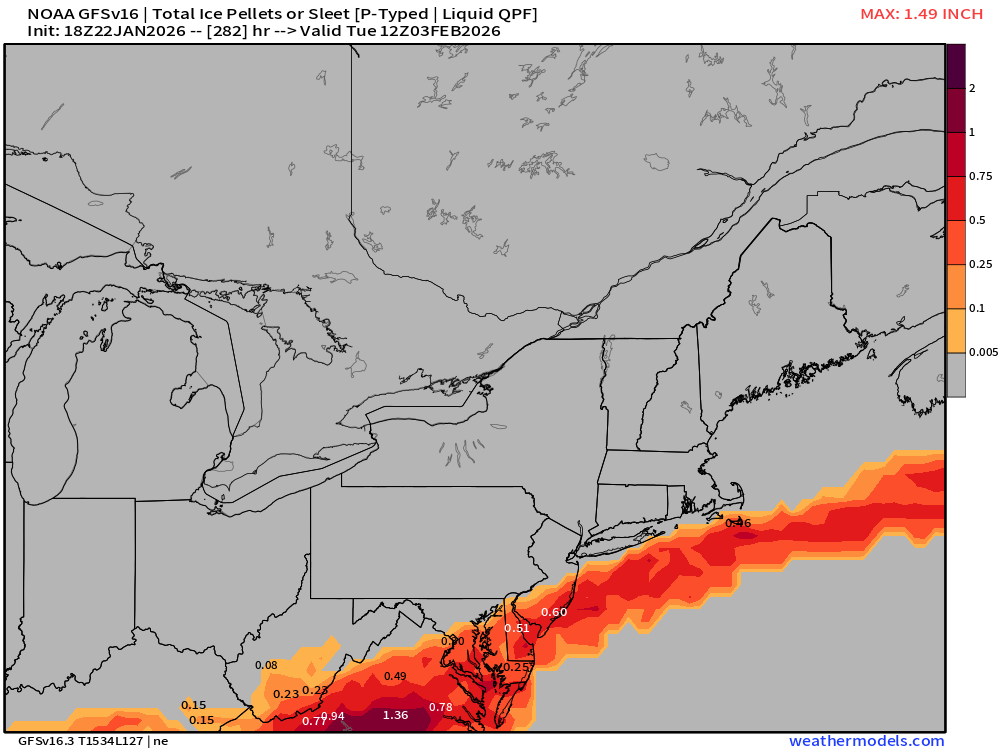
-
January 25-26 Winter Storm Potential
Hurricane Agnes replied to Ralph Wiggum's topic in Philadelphia Region
Pivotal's maps don't have a separate "sleet" frame. Just the frozen. ETA - 18z EC is running. Will see what that has to say! -
January 25-26 Winter Storm Potential
Hurricane Agnes replied to Ralph Wiggum's topic in Philadelphia Region
That's the next Thursday storm I think (vs this weekend)! Trying to get through this one! -
January 25-26 Winter Storm Potential
Hurricane Agnes replied to Ralph Wiggum's topic in Philadelphia Region
I have been going through that and the MA gets huge amounts of sleet but not up here based on that GFS run!