Hurricane Agnes
-
Posts
9,291 -
Joined
Content Type
Profiles
Blogs
Forums
American Weather
Media Demo
Store
Gallery
Everything posted by Hurricane Agnes
-
January 25-26 Winter Storm Potential
Hurricane Agnes replied to Ralph Wiggum's topic in Philadelphia Region
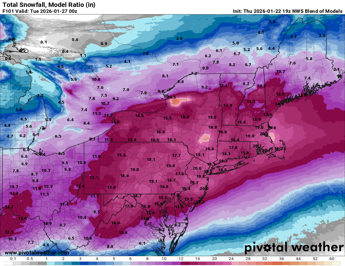
19z NBM (18z ICON is running).

-
January 25-26 Winter Storm Potential
Hurricane Agnes replied to Ralph Wiggum's topic in Philadelphia Region
Heard about the shortage on the radio this morning. I bought a couple jugs over the past years when I happened to see them at the supermarket and still have a couple intact and one partial (and I keep one in my car). I remember back in '94, people were using kitty litter to spread on the ice. -
January 25-26 Winter Storm Potential
Hurricane Agnes replied to Ralph Wiggum's topic in Philadelphia Region
I remember there were over a dozen ice storms from December '93 into January/February '94. It was a frigging mess. I don't know if any happened when it was teens here in the city but some of the temps were pretty frigid. During one of the worst of them in January '94, I had to go down to Baltimore on a work trip and was going to take Amtrak but was driving to 30th St. Station to park and hop the train. On my way there as the storm was underway, I was about to go up on the Expressway when I heard on KYW that it was icy so I bypassed the exit ramp from Lincoln Drive to go up that way, and took the Kelly Drive instead. Found out later that people were trapped on the Expressway for something like 8 hours as cars/trucks got stuck on the ramps and no one could get on or off. That was also a time when the area was all out of road and consumer salt. So when I was down in Baltimore, I bought a couple bags of halite (they only had plain rain down there) and brought that back for my mom. For the rest of that winter, she was the only one on her block with a walk clear and dry to the pavement! But sadly enough, there was a red cedar tree between her house and her neighbor's that was at least 30ft tall and the ice literally coated the tree and uprooted the whole thing, which ended up splayed across the front yards and halfway into the street. -
January 25-26 Winter Storm Potential
Hurricane Agnes replied to Ralph Wiggum's topic in Philadelphia Region
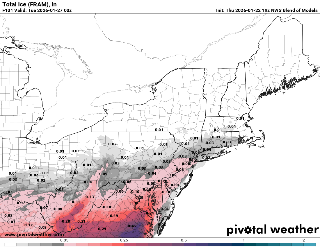
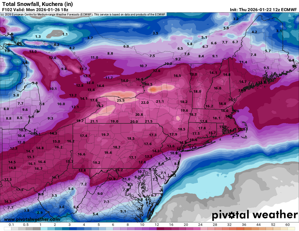
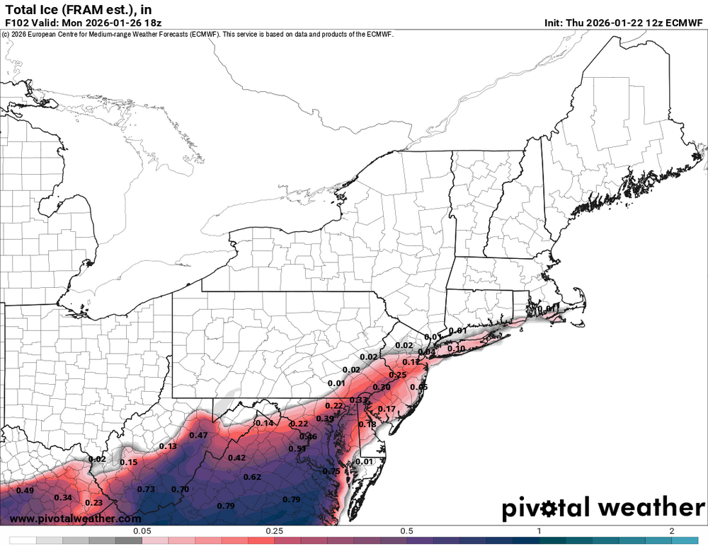
12z Euro and also including their ice prog -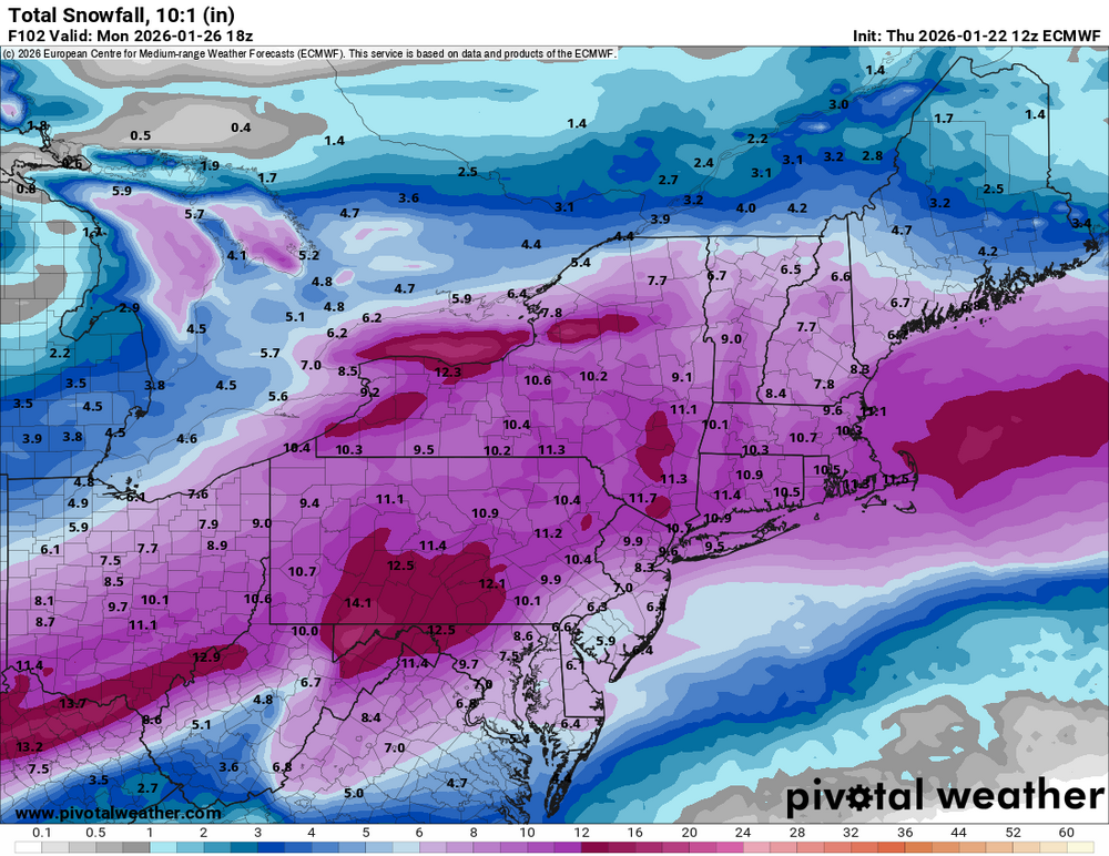
-
January 25-26 Winter Storm Potential
Hurricane Agnes replied to Ralph Wiggum's topic in Philadelphia Region
12z ICON for informational purposes -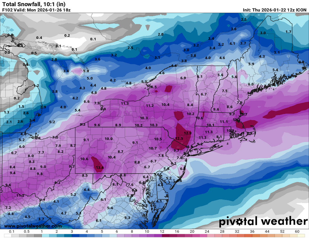
-
January 25-26 Winter Storm Potential
Hurricane Agnes replied to Ralph Wiggum's topic in Philadelphia Region
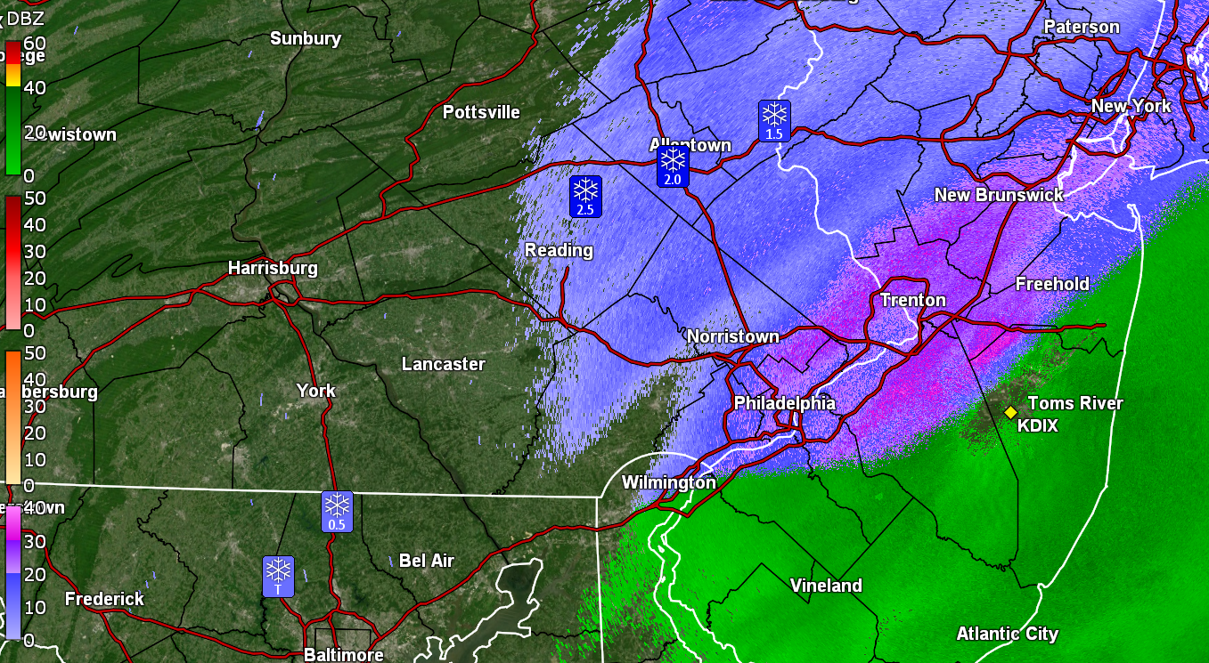
Here's the Winter Storm Watch up for Philly metro - -
January 25-26 Winter Storm Potential
Hurricane Agnes replied to Ralph Wiggum's topic in Philadelphia Region
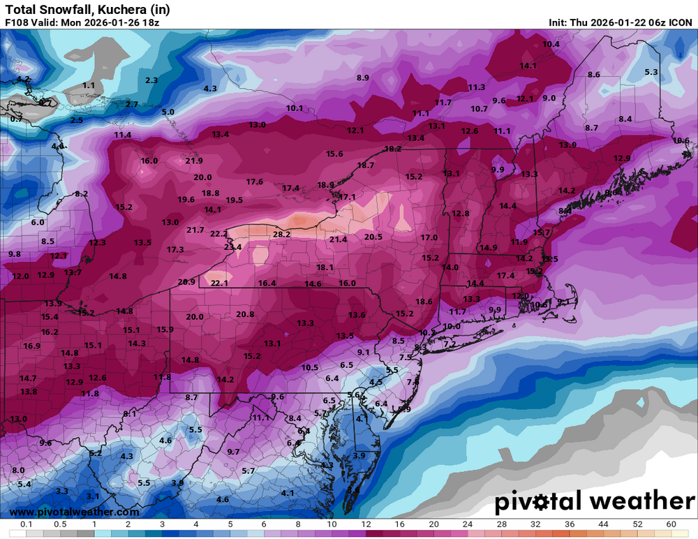
It looks like the bottom part has separated. I don't normally keep the inner tube in there for winter but keep the outer one for when I might want to calculate snow ratios. I forgot it was still in there. I may end up going on and getting a new one as this one has gotten battered over the years. I mainly used it to verify my weather station. I didn't see if anyone posted the 6z ICON but if not, here it is (looks like the amounts are cut down as other models have shown) -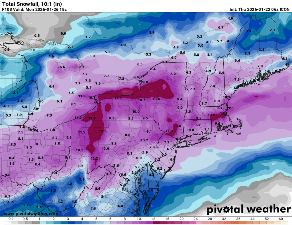
-
January 25-26 Winter Storm Potential
Hurricane Agnes replied to Ralph Wiggum's topic in Philadelphia Region
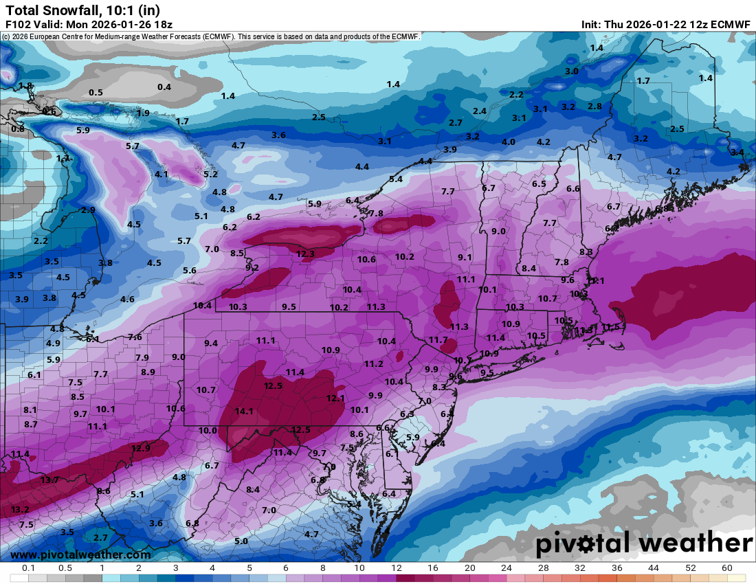
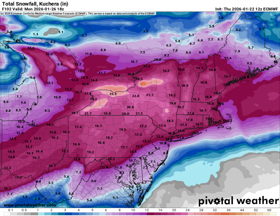
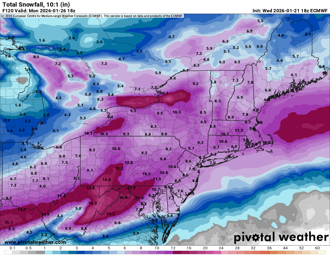
The small tube in my Stratus got a crack at some point so need to replace that. And for completeness - the EC 18zs...

-
January 25-26 Winter Storm Potential
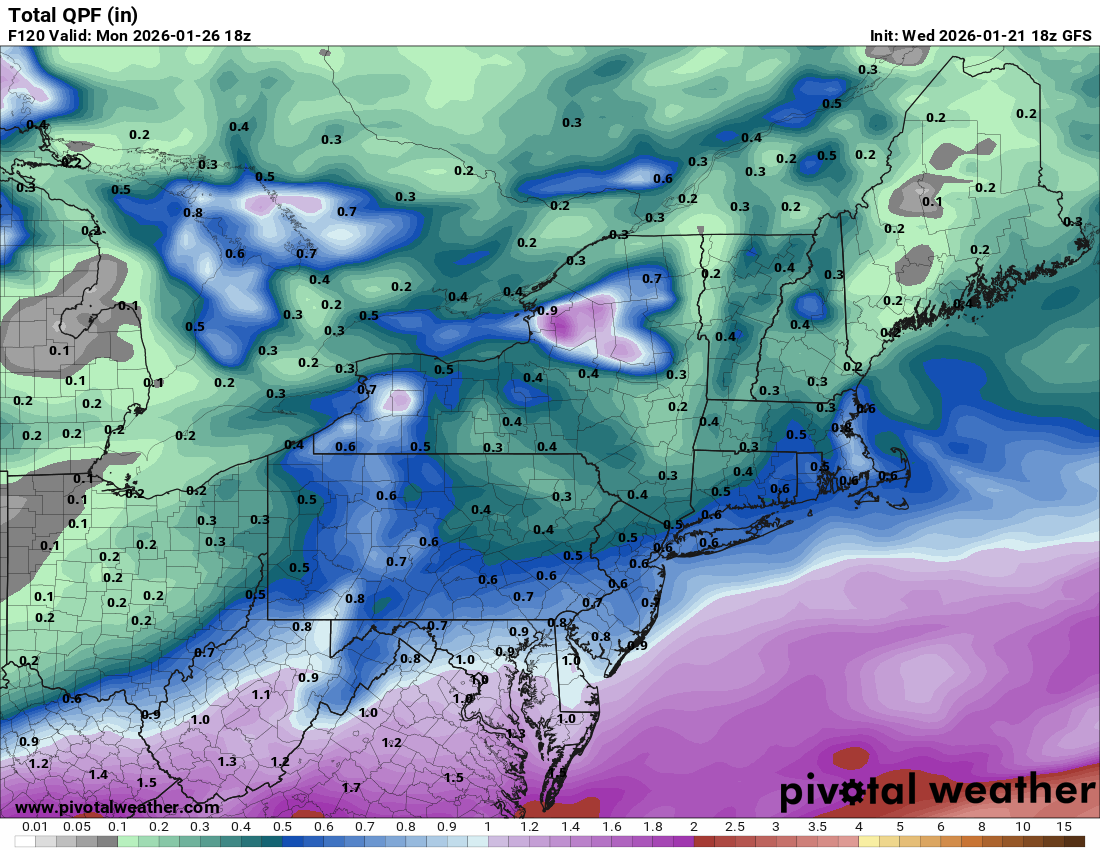
Hurricane Agnes replied to Ralph Wiggum's topic in Philadelphia Region
18z GFSes (total qpf) -

-
January 25-26 Winter Storm Potential
Hurricane Agnes replied to Ralph Wiggum's topic in Philadelphia Region
The ICON goes way west, with the Gulf low coming up through the east central, almost like an apps runner, and then it pops out off the Jersey coast. 18z GFS is running so will see what that shows. This is why I hate this time frame! -
January 25-26 Winter Storm Potential
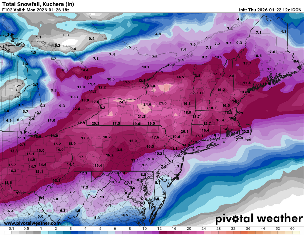
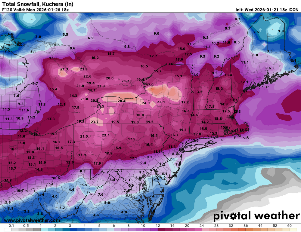
Hurricane Agnes replied to Ralph Wiggum's topic in Philadelphia Region
18z ICON just got done. Here is out to 120 hours -
-
January 25-26 Winter Storm Potential
Hurricane Agnes replied to Ralph Wiggum's topic in Philadelphia Region
18z 12k NAM last frame shows the beginning of it.
-
January 25-26 Winter Storm Potential
Hurricane Agnes replied to Ralph Wiggum's topic in Philadelphia Region
This is why I hate this time frame - the "mid range". Someone needs to develop a good "mid range" model because the shifts between the long range and mid range, are almost always nerve wracking! Hopefully when we get into NAM range, which will start tomorrow, we'll see stuff nailing down more. The 12k NAM is running right now and the end frames may capture some of it. -
E PA/NJ/DE Winter 2025-26 Obs/Discussion
Hurricane Agnes replied to LVblizzard's topic in Philadelphia Region
That's what prompted my sis to text this morning (Apple app). She is in Delco and hers said 11" - 13". As a quick obs, I bottomed out at 15 and so far hit 33 for a high. Currently 32 with dp 23 and lots of puffy cumulus. -
E PA/NJ/DE Winter 2025-26 Obs/Discussion
Hurricane Agnes replied to LVblizzard's topic in Philadelphia Region
The regular EC is still running but below is the EC AI -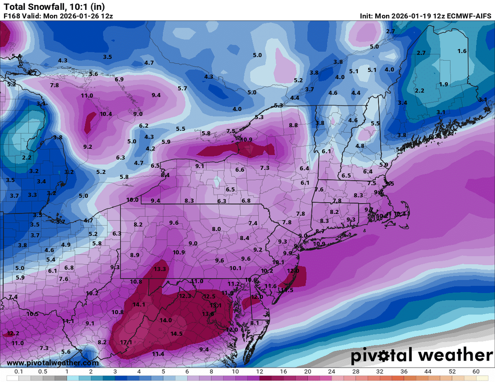
-
E PA/NJ/DE Winter 2025-26 Obs/Discussion
Hurricane Agnes replied to LVblizzard's topic in Philadelphia Region
12z Ukie 10:1 & Kuchera (pick your poison).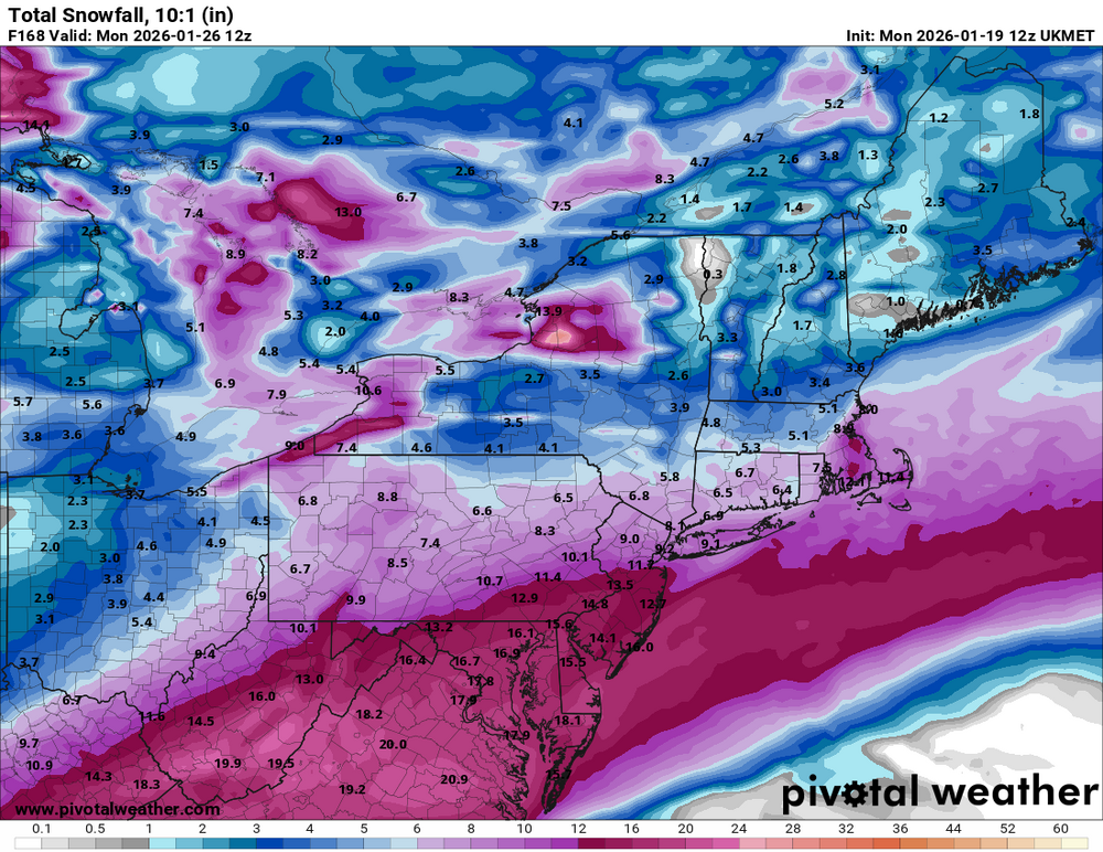
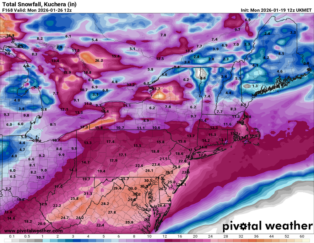
-
January 18th Back Door NW Trend Snow OBS Thread
Hurricane Agnes replied to Mikeymac5306's topic in Philadelphia Region
When the Euro and the NAM agree over multiple runs, then... -
January 18th Back Door NW Trend Snow OBS Thread
Hurricane Agnes replied to Mikeymac5306's topic in Philadelphia Region
Holy crap. Just went out to measure (had cleared the board a few hours ago just as it started) and got another 2.5" on top of the earlier 1.25", making it 3.75" for the day and 5.25" over the 2 days. Once that temp got below 32, the stuff started piling up. That officially took me over the foot mark for snow this season so far. Currently partly cloudy (with stars visible) and 27 with dp 26.
-
January 18th Back Door NW Trend Snow OBS Thread
Hurricane Agnes replied to Mikeymac5306's topic in Philadelphia Region
Temp has dropped to 32 (with dp 32) here and this latest round is now starting to dust the treated surfaces that were previously wet and the dripping has slowed. Currently fine-flake SN with some fog starting up. -
January 18th Back Door NW Trend Snow OBS Thread
Hurricane Agnes replied to Mikeymac5306's topic in Philadelphia Region
Got maybe 1/4" on top of the inch, from a band that had been sitting over me but now down to snizzle with fine flakes, a temp of 33 with dp of 32, and lots of melting going on. Total 1.25" for the day so far and 2.75" for the 2-day event. The coastal is sitting off the coast of VA.
-
January 18th Back Door NW Trend Snow OBS Thread
Hurricane Agnes replied to Mikeymac5306's topic in Philadelphia Region
Have pancakes flying now with SN & fog, and am up to an inch with this round 2 (2.5" for the 2-day total so far). Temp still holding at 32 with dp 32.
-
January 18th Back Door NW Trend Snow OBS Thread
Hurricane Agnes replied to Mikeymac5306's topic in Philadelphia Region
Had dropped down to SN- for a bit but now got under some heavier returns (treated walks and streets starting to cave) and am back to SN, with about 1/2" with this latest round. Temp holding at 32 wit dp 32, with some of the fog gone.
-
January 18th Back Door NW Trend Snow OBS Thread
Hurricane Agnes replied to Mikeymac5306's topic in Philadelphia Region
SN with some fatties mixed in and fog, that started here within the past hour or so. Has already laid down a 1/4" coating on bare surfaces (e.g., cars that had cleared the snow and been out on the road last night). Temp 32 with dp 32. -
E PA/NJ/DE Winter 2025-26 Obs/Discussion
Hurricane Agnes replied to LVblizzard's topic in Philadelphia Region
WWA issued for the I-95 corridor counties - Also a SPS for fog around the area that have some snowpack. Currently below freezing here at 29 with dp 28,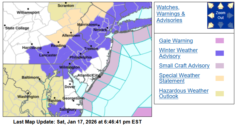
-
E PA/NJ/DE Winter 2025-26 Obs/Discussion
Hurricane Agnes replied to LVblizzard's topic in Philadelphia Region
Almost every MLK day (and the actual date varies but is the "3rd Monday" of the month) there is either an arctic blast and/or some kind of wintry event. It's like that "first week of December" type of pattern.