Hurricane Agnes
-
Posts
9,336 -
Joined
Content Type
Profiles
Blogs
Forums
American Weather
Media Demo
Store
Gallery
Everything posted by Hurricane Agnes
-
E PA/NJ/DE Summer 2024 Obs/Discussion
Hurricane Agnes replied to JTA66's topic in Philadelphia Region
Sounds like a gust front is trying to come through. After the last round, the temp recovered back up to around 83. Now it is dropping and down to 79 with dp 75.
-
E PA/NJ/DE Summer 2024 Obs/Discussion
Hurricane Agnes replied to JTA66's topic in Philadelphia Region
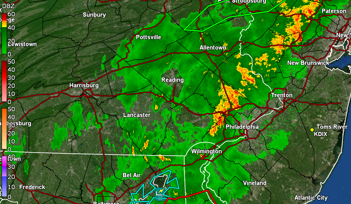
Well that little blob disintegrated as it passed over me. Apparently it deluged the roadways in Chester County and then Montgomery County on its way here, including Conshohocken and other places along the way, per KYW's traffic report. Picked up 0.05" from it. There's another cluster going through Delco at the moment and will most likely miss me to the south. Currently mostly cloudy but clearing and 79 with dp 73. It did make it up to 95 as a high here after a low of 72 this morning. -
E PA/NJ/DE Summer 2024 Obs/Discussion
Hurricane Agnes replied to JTA66's topic in Philadelphia Region
Have a blob on my doorstep. Lots of convection associated with it. Has gotten breezy (may be the gust front) and temp has dropped down to 88 with dp 73.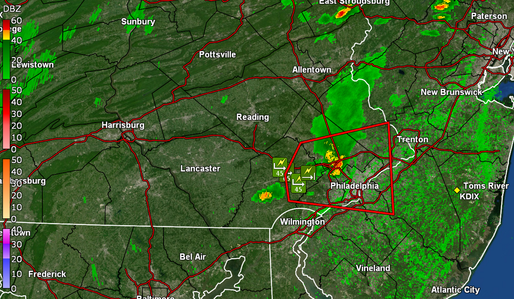
-
E PA/NJ/DE Summer 2024 Obs/Discussion
Hurricane Agnes replied to JTA66's topic in Philadelphia Region
Thunder boomer Watches up - IMBY, today is day 5 of the current heatwave with temps at or above 90. So far this month, I have had 13 days of 90 and above and with 9 days in June, season to date total is a whopping 22 (and we haven't even finished off July yet let alone gone through August). Currently a partly sunny and hazy 94 with dp 73. -
E PA/NJ/DE Summer 2024 Obs/Discussion
Hurricane Agnes replied to JTA66's topic in Philadelphia Region
"Strobing" is the perfect term! I finished up with 0.25" of rain but I'll take it. At least it knocked the temps down about 25 degrees and gave the plants some moisture. Definitely not enough for all the brown/dormant grass around here though. Have already bottomed out at 72 this morning and it's currently mostly cloudy, misty, and 74, with dp 72. -
E PA/NJ/DE Summer 2024 Obs/Discussion
Hurricane Agnes replied to JTA66's topic in Philadelphia Region
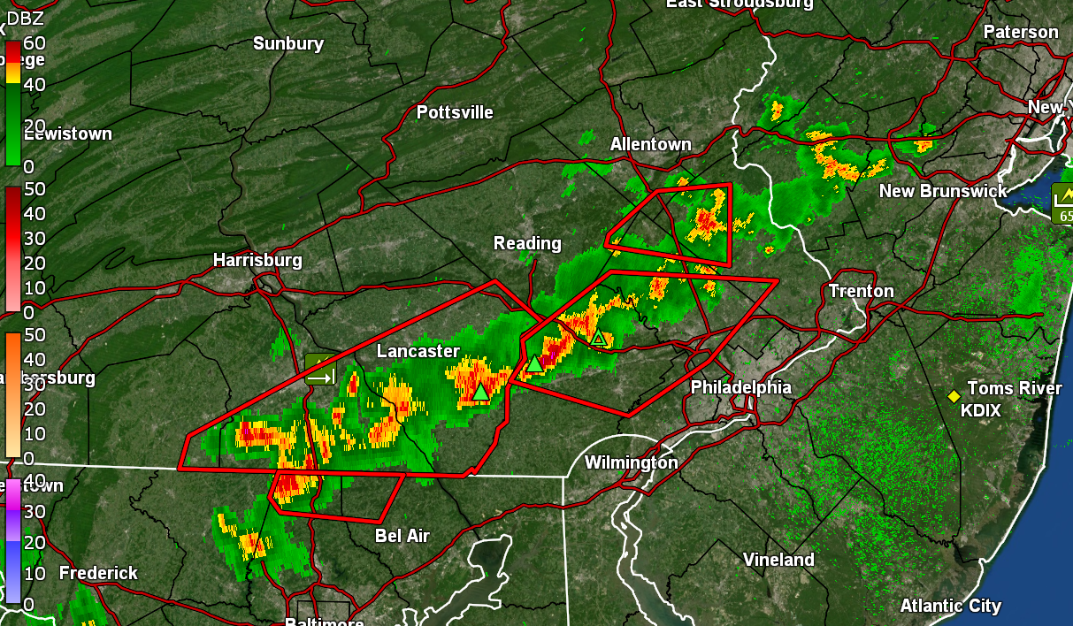
Getting a lot of cloud-to-cloud lightning. It's almost continuous. Briefly had almost 1.5"/hr rates but the line is a fast-mover, so not much to show for all the sound and fury so far - 0.23" in the bucket at post time but I'll take it! Temp is down to 75 with dp 72. -
E PA/NJ/DE Summer 2024 Obs/Discussion
Hurricane Agnes replied to JTA66's topic in Philadelphia Region
Am under the leading edge of the line. Lots of wind and lightning although not much if any thunder. Gully washer underway! Temp has dropped down to 80 with dp 76. -
E PA/NJ/DE Summer 2024 Obs/Discussion
Hurricane Agnes replied to JTA66's topic in Philadelphia Region
I was watching that line consolidate and decided to go ahead and put my patio umbrella down. Will see if that holds together all the way to the city. Still 91 here with dp 75 and overcast.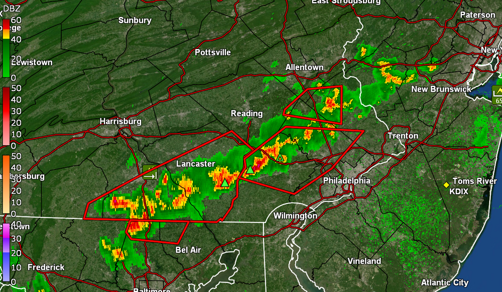
-
E PA/NJ/DE Summer 2024 Obs/Discussion
Hurricane Agnes replied to JTA66's topic in Philadelphia Region
Norman up with the watches - After a low of 76 this morning, I did easily make it up to 98 today for a high (so far) and it's currently a mostly sunny 3 H day, with temp bopping between 96 & 97, and with dp 77. -
E PA/NJ/DE Summer 2024 Obs/Discussion
Hurricane Agnes replied to JTA66's topic in Philadelphia Region
Sun out. Finished up with 0.76" with that round and temp is rebounding, up to 75 with dp 75. -
E PA/NJ/DE Summer 2024 Obs/Discussion
Hurricane Agnes replied to JTA66's topic in Philadelphia Region
Down to light rain now. So far got 0.76 in the bucket from that round. Temp is down to 73 with dp 72. Still some leftover convection around. -
E PA/NJ/DE Summer 2024 Obs/Discussion
Hurricane Agnes replied to JTA66's topic in Philadelphia Region
Was getting >3.5"/hr at one point. Have 0.62" in the bucket. -
E PA/NJ/DE Summer 2024 Obs/Discussion
Hurricane Agnes replied to JTA66's topic in Philadelphia Region
Am under heavy returns now (finally). Almost 1"/hr. Temp down to 75 with dp 73 and lots of convection and thunder.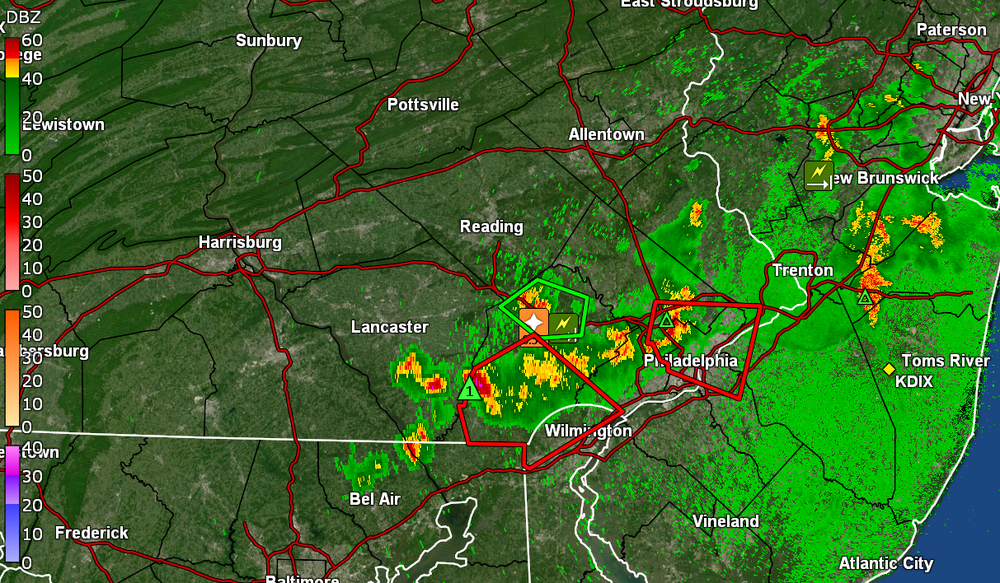
-
E PA/NJ/DE Summer 2024 Obs/Discussion
Hurricane Agnes replied to JTA66's topic in Philadelphia Region
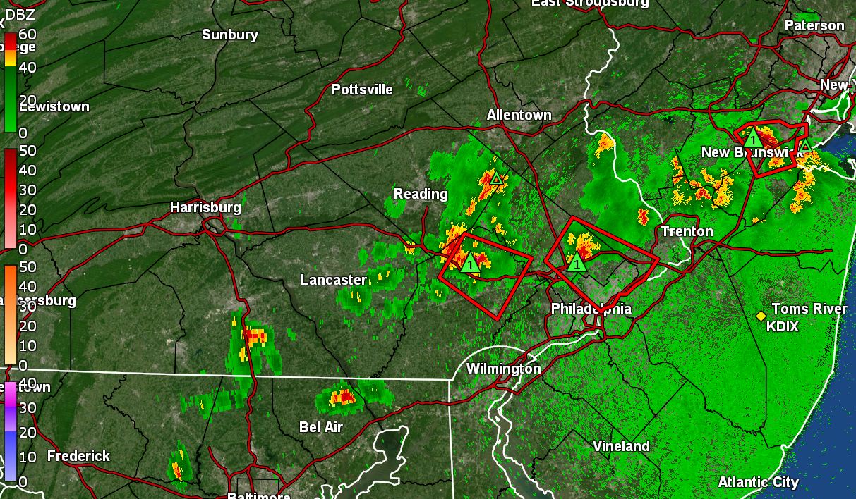
Junk and stuff incoming and just got warned over Philly. Of course I pulled out the hose earlier this morning because 0.18" of rain in 2 weeks with 10 of those days at 90+, requires some kind if irrigation! It actually hit 97 here today for what will probably be the high, after a 75 low. It's currently overcast and threatening, with lots of convection around the area, some occasional thunder, and temp now down to 88 with dp 74.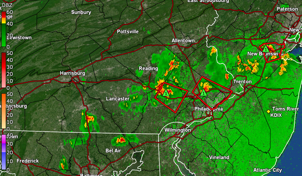
-
E PA/NJ/DE Summer 2024 Obs/Discussion
Hurricane Agnes replied to JTA66's topic in Philadelphia Region
Ended up going no higher than 80 yesterday after a low of 72 so a nice break. However I only got 0.08" of rain for all of yesterday and nada overnight. Am at 0.18" for the month of July so far. After a 73 low this morning, currently 85 and partly sunny with dp 75 -
E PA/NJ/DE Summer 2024 Obs/Discussion
Hurricane Agnes replied to JTA66's topic in Philadelphia Region
Topped out at 95 yesterday after a 79 low and was surprised to have gotten anything at all from the overnight line where I picked up 0.10" sometime between 2 - 3 am this morning. That was my first rain for the month of July. Had a "cooler" low of 74 this morning and I did briefly touch 90 just after 1 pm today, making it day 8 of the heatwave and temps at or above 90. Currently 89 and mostly sunny, with a MUCH BETTER dp of 69 ("much better" meaning not dps of 79 and 80 like the past couple days even when 69 starts getting rough ). -
E PA/NJ/DE Summer 2024 Obs/Discussion
Hurricane Agnes replied to JTA66's topic in Philadelphia Region
I hit my highest temp of the season so far with a 98 yesterday after a 74 low. Low this morning was 76 and have already hit 90 again today. Did a "90s+" count for the season so far and came up with 9 days at 90 or above in June and now 6 in July. Currently partly sunny and hazy with a disgusting dewpoint bopping between 79 & 80! -
E PA/NJ/DE Summer 2024 Obs/Discussion
Hurricane Agnes replied to JTA66's topic in Philadelphia Region
Looks like I made it up to 97 as a high today with a dp that got as high as 81 at one point. Currently a hazy 94 with dp 74. -
E PA/NJ/DE Summer 2024 Obs/Discussion
Hurricane Agnes replied to JTA66's topic in Philadelphia Region
Tapped 96 at 12:28 and it's definitely HHH which at least earlier this morning, kept the blazing sun off of stuff (although it's out now but with lots of cumulus). Currently 95 with dp 77. -
E PA/NJ/DE Summer 2024 Obs/Discussion
Hurricane Agnes replied to JTA66's topic in Philadelphia Region
Now not long after noon and 95 with dp 76 so I guess it's "mixing out" (*sarcasm*). -
E PA/NJ/DE Summer 2024 Obs/Discussion
Hurricane Agnes replied to JTA66's topic in Philadelphia Region
I briefly tapped 94 about 35 minutes ago and it's currently 93 with dp 78. And yup, the Beryl FIREHOSE is in play!!! (UL Water Vapor below)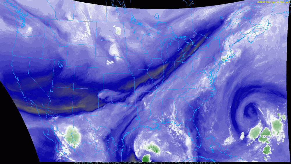
-
E PA/NJ/DE Summer 2024 Obs/Discussion
Hurricane Agnes replied to JTA66's topic in Philadelphia Region
Just after 9 am, I spiked to 89 with a dp of 82. Some configuration of something is drawing GOM moisture up here. ETA - I see TS Beryl is showing up on the below map. Maybe that is churning some stuff up the front.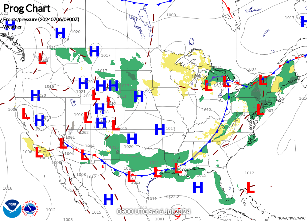
-
E PA/NJ/DE Summer 2024 Obs/Discussion
Hurricane Agnes replied to JTA66's topic in Philadelphia Region
After a 77 low yesterday, I got up to 95 for a high and with Thursday's 91/68, today will be day 3 of 90+ to start another heatwave IMBY. Same here on both July 4 & yesterday. Rain to the north and to the south and something that looked like it was headed this way yesterday fizzled before it got here. Didn't even get any surprise tiny pop-ups. Right now, at 8:30 am here (after a low of 79), the temp is 86 with dp 80. The "feels like" on the station says "99.7". -
E PA/NJ/DE Summer 2024 Obs/Discussion
Hurricane Agnes replied to JTA66's topic in Philadelphia Region
Round 3 showers gave me an additional 0.06" for 0.71" for the day (0.78" 2-day). Skies want to clear but too much stuff up there. Currently overcast and 74 with dp 73. -
E PA/NJ/DE Summer 2024 Obs/Discussion
Hurricane Agnes replied to JTA66's topic in Philadelphia Region
That round finished up with 0.65" in the bucket for today (0.72" 2-day total). Currently misty and 75 with dp 74.