Hurricane Agnes
-
Posts
9,336 -
Joined
Content Type
Profiles
Blogs
Forums
American Weather
Media Demo
Store
Gallery
Everything posted by Hurricane Agnes
-
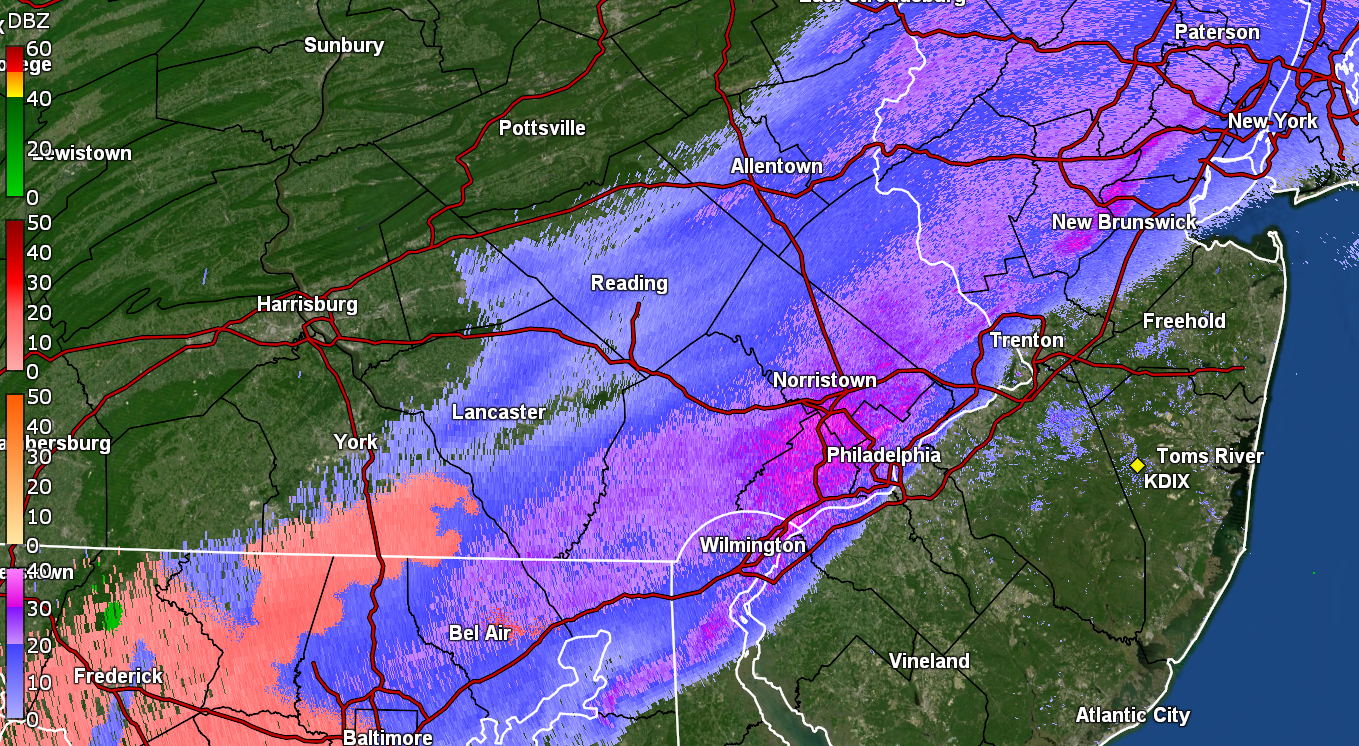
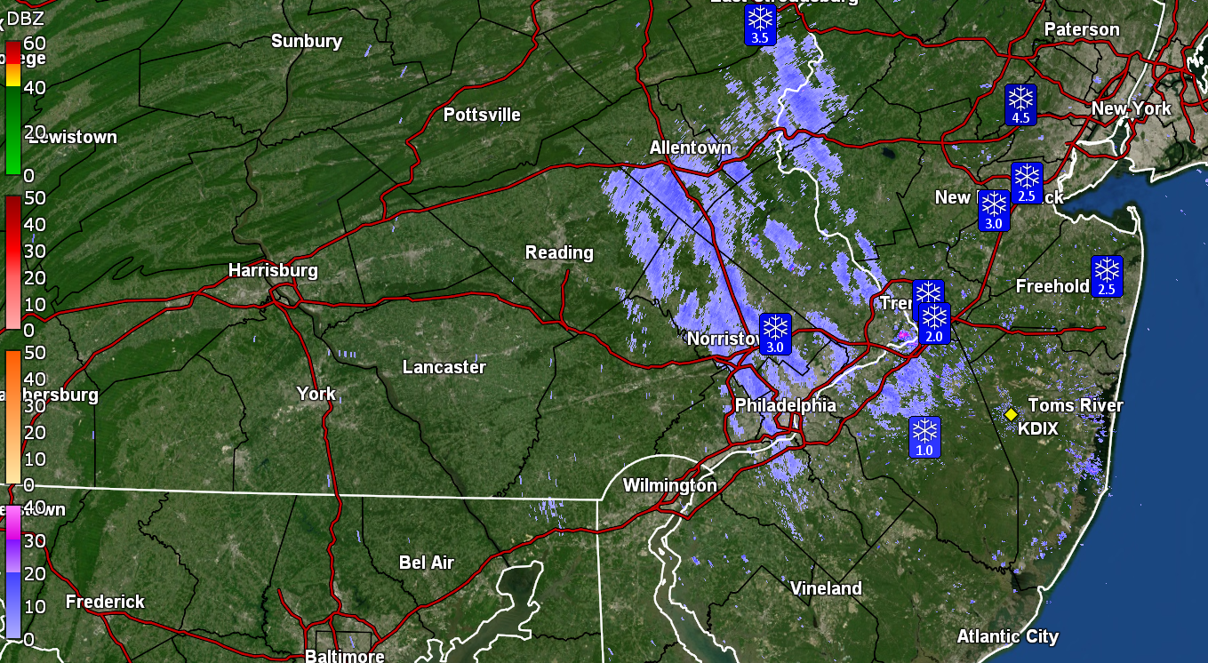
January 3, 2025 Light Snow Event Observations
Hurricane Agnes replied to ChescoWx's topic in Philadelphia Region
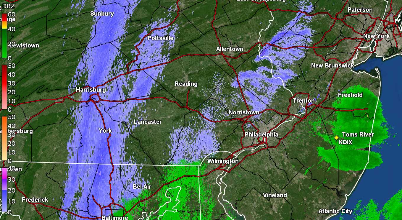
Here I am (I'm still here ). Started getting flakes about an hour ago and it has been sticking on the colder surfaces. So far have a coating of about 1/4" from a fine-flaked SN and temp of 32, with dp 30. Had made it up to 38 for a high after bottoming out at 29. -
E PA/NJ/DE Winter 2024/25 Obs/Discussion
Hurricane Agnes replied to JTA66's topic in Philadelphia Region
Although the radar was "bright" over my area in NW Philly, the snow never got above about a SN- so I just measured 1/4". I didn't see any mixing either nor was there any IP. It is pretty powdery and if there is any wind that picks up it would probably blow away. Currently overcast and 29 with dp 26. -
E PA/NJ/DE Winter 2024/25 Obs/Discussion
Hurricane Agnes replied to JTA66's topic in Philadelphia Region
Have fine flakes going this morning. So far had a low of 23 earlier this morning ~3:40 am, and the temp has slowly been rising since. Currently 27 with dp 22 and a light dusting. That year was awful. As PhiEaglesFan noted, the last time PHL went below 0. It was also the multiple ice storm year when almost all of the commercial and retail salt was gone out of the tristate area and there were "caravans" of trucks of road salt being brought down from NY and other points north. I remember having to go on a work trip during the worst of the ice storms (I think ~Jan. 7 or so) and was headed to 30th St. station to take the train down to Baltimore. I almost went up on the Expressway but thought better of it and continued onto the Kelly Drive and thank goodness I didn't go up there because it ended up completely closed down for hours as cars/trucks got stuck on all the on/off ramps. In Baltimore, I was able to find some bags of Halite, bought a couple to bring home packed in my suitcase, and gave to my mom. She was the only one on her block with a sidewalk clear and dry to the pavement.
-
E PA/NJ/DE Winter 2024/25 Obs/Discussion
Hurricane Agnes replied to JTA66's topic in Philadelphia Region
Bottomed out at 8.4F this morning just after sunrise at 7:25 am. The last time it hit a single digit temp IMBY was December 2022 (with a 5.4F) - literally the same period with a 7.0F 12/23/22 & a 5.4F 12/24/22. Also had the same type of pattern back in 2022 that is progged this year, with a "warm up" around New Years. Am now up to 10 and rising, with dp 3. -
E PA/NJ/DE Winter 2024/25 Obs/Discussion
Hurricane Agnes replied to JTA66's topic in Philadelphia Region
Bottomed out at 14 yesterday and only made it to 22 as a high. This morning, the bottom is falling out (although there is still a light breeze so that might kill any efficient radiational cooling). Am currently 10 with a dp of 4. Humidifiers are struggling. -
E PA/NJ/DE Winter 2024/25 Obs/Discussion
Hurricane Agnes replied to JTA66's topic in Philadelphia Region
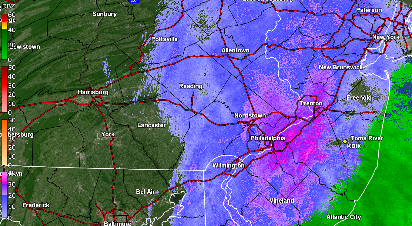
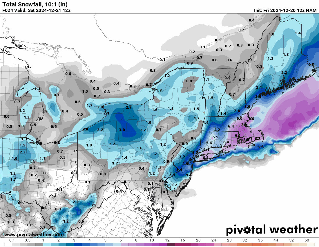
Measured 2.70" this morning and bottomed out at 28. There's a streamer of something overhead although it's been mostly virga so far. Currently overcast and 30 with dp 23. Happy first day of winter!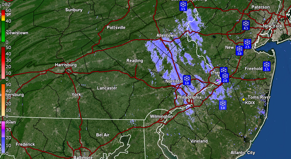
-
E PA/NJ/DE Winter 2024/25 Obs/Discussion
Hurricane Agnes replied to JTA66's topic in Philadelphia Region
I reported just over an hour ago in this thread for where I am in NW Philly up in the hills and had 1" at the time. See below - Just went out again and am now up to 1.75" of paste. This stuff is really wet and is plastered all over the trees and shrubs. Lots of dripping going on as well. The walks are still wet but parts of the streets near the pavement started to cave a bit. Currently 32 with dp 31 and SN-.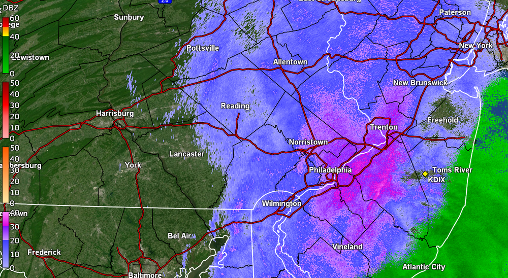
-
E PA/NJ/DE Winter 2024/25 Obs/Discussion
Hurricane Agnes replied to JTA66's topic in Philadelphia Region
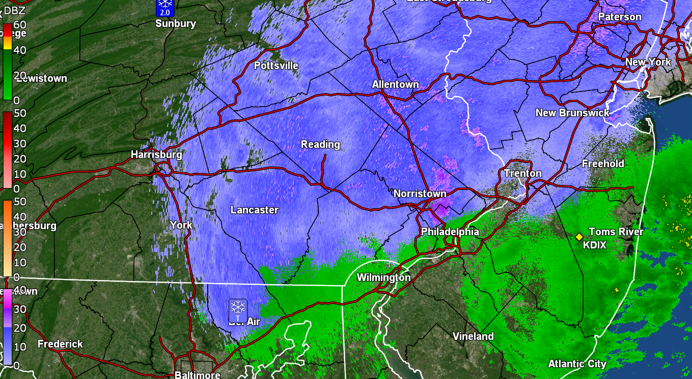
Still have SN- to SN and got a measurement of 1" IMBY in NW Philly so far (~8:10 pm). It's wet stuff and there's lots of dripping going on as the temp has been right around freezing. Walks and streets are still wet but cars, grassy areas, and colder surfaces are covered. Currently 32 & dp 32, with light snow and fog.
-
E PA/NJ/DE Winter 2024/25 Obs/Discussion
Hurricane Agnes replied to JTA66's topic in Philadelphia Region
Have a coating on grassy areas and some cars but the walks and streets haven't caved yet. Currently SN and 33 with dp 32. -
E PA/NJ/DE Winter 2024/25 Obs/Discussion
Hurricane Agnes replied to JTA66's topic in Philadelphia Region
Had a bit of a flizzard earlier but now some heavier returns have blown up over me with SN-. Nothing is sticking as the temp is 34 but have been getting the bigger flakes.
-
E PA/NJ/DE Winter 2024/25 Obs/Discussion
Hurricane Agnes replied to JTA66's topic in Philadelphia Region
12z NAM is running and grabbed an hour 24 image.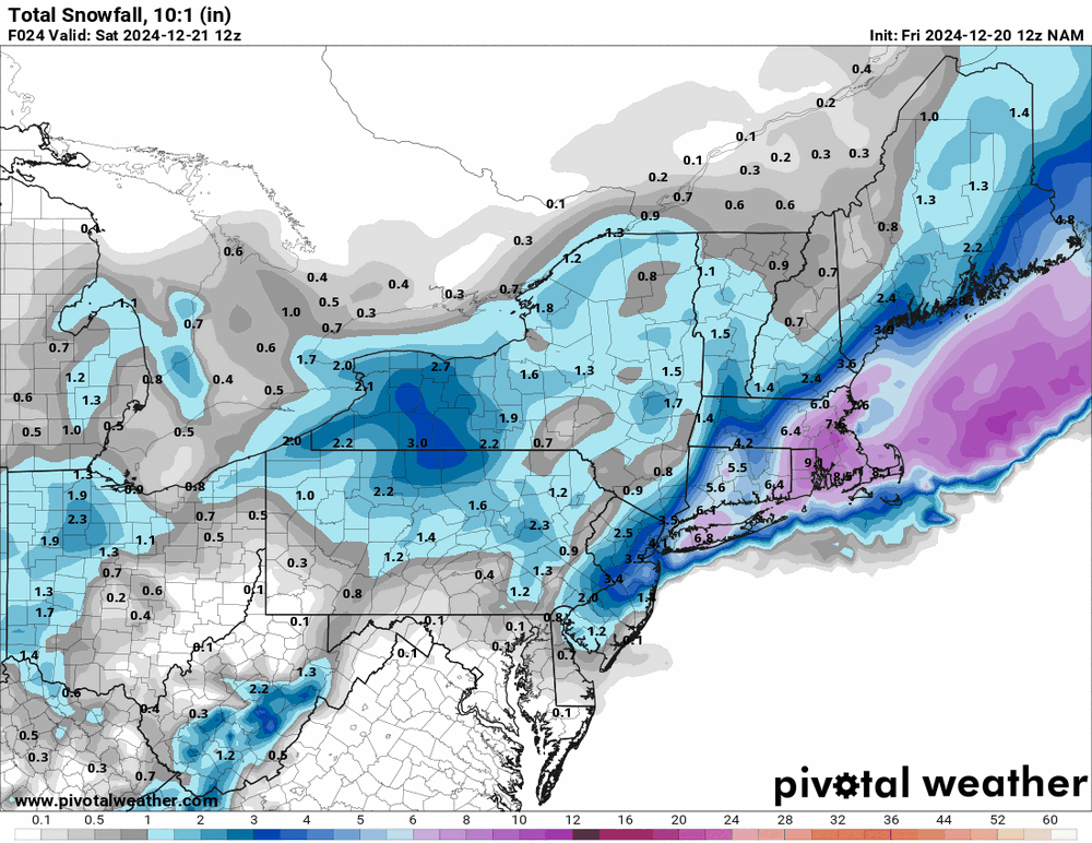
-
E PA/NJ/DE Winter 2024/25 Obs/Discussion
Hurricane Agnes replied to JTA66's topic in Philadelphia Region
Getting some mood flakes this morning. Threw my windshield cover on just in case things ice up with the arctic temps hit this weekend. Made it up to 44 yesterday after a 35 low and it's currently an overcast and flurrying 34 (and has been dropping a bit), with dp 28, and watching some incoming.
-
E PA/NJ/DE Fall 2024 Obs/Discussion
Hurricane Agnes replied to Rtd208's topic in Philadelphia Region
After a 37 low yesterday, made it up to 49 for a high but this morning's "low" is apparently non-diurnal as the temp has been rising since midnight, with that midnight low of 48. The first rainy period 12/9 -12/11 resulted in 1.21" and this current 3-day event (12/15 - 12/17) has me at 1.14" so far. I noticed that models are trending colder for that Christmas period but we are in the sucky midrange so will see. Currently a misty 50, with some fog, low stratus and a dp of 50. -
E PA/NJ/DE Fall 2024 Obs/Discussion
Hurricane Agnes replied to Rtd208's topic in Philadelphia Region
Well I have to report that the Dec. 5 snowmaggedon actually netted me a few mood flakes as I was headed out the door around 1:30 pm. This morning's lake effect streamer was virga here. Made it up to 42 yesterday ahead of the front and bottomed out at 28 this morning. Currently sunny and 32 with dp 15. Plus he was a great DJ on WFIL!- 1,105 replies
-
- 1
-

-
- tropics
- heavy rainfall
- (and 5 more)
-
E PA/NJ/DE Fall 2024 Obs/Discussion
Hurricane Agnes replied to Rtd208's topic in Philadelphia Region
The Snow Squall Warning got expanded a bit south - Sun is out but will see if the bottom of that line will survive to get here. Currently 39 with dp 29. -
E PA/NJ/DE Fall 2024 Obs/Discussion
Hurricane Agnes replied to Rtd208's topic in Philadelphia Region
Snow Squall Warning up N & E of Philly metro - It seemed any frozen had melted as it approached the city limits. My sis in Delco got a flizzard last night but nada here. Ended up with 0.04" of liquid between midnight and 2 am and then another 0.01" of rain between 6 - 7 am. Got up to 40 yesterday after a low of 24 and what might be my high today was just after midnight of 41. It did stay above freezing overnight. Currently a misty 38 with dp 33.- 1,105 replies
-
- 1
-
-
- tropics
- heavy rainfall
- (and 5 more)
-
E PA/NJ/DE Fall 2024 Obs/Discussion
Hurricane Agnes replied to Rtd208's topic in Philadelphia Region
I finished up with 0.35" total yesterday before the system moved out, giving me a 4-day event total of 1.78". I really didn't see any mixing at all here other than what might have been intermittent white rain (had to stare closely), so it was pretty much an all-rain event here (at least what made it down to the surface). My high yesterday was just after midnight at 40. I bottomed out much warmer (relative) this morning at 47 and it's currently a mostly sunny 50, with some puffy cumulus bubbling up, and dp 37. -
E PA/NJ/DE Fall 2024 Obs/Discussion
Hurricane Agnes replied to Rtd208's topic in Philadelphia Region
Still getting all light rain and have an additional 0.08" in the bucket for 0.11" for the day (so far), which his 1.50" 3-day total, and probably should add the 0.04" from the 19th, for a 1.54" 4-day total. The temps continue to ease down and I'm currently at 36 with dp 35 with light rain.- 1,105 replies
-
- 1
-
-
- tropics
- heavy rainfall
- (and 5 more)
-
E PA/NJ/DE Fall 2024 Obs/Discussion
Hurricane Agnes replied to Rtd208's topic in Philadelphia Region
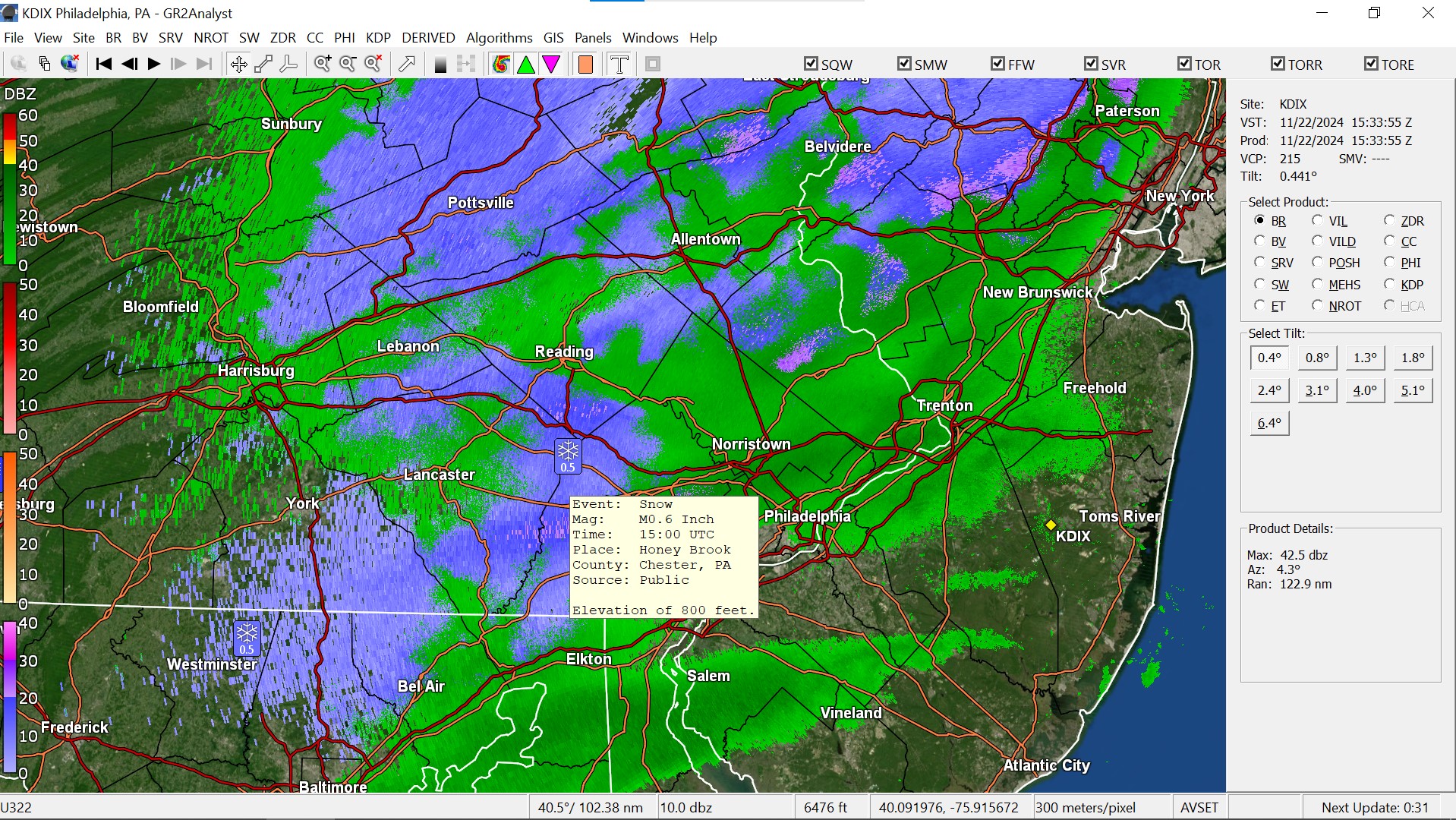
Haven't had any flakes here but had drizzle enough to wet the walk earlier and am now under a band of some light rain that has deposited 0.03" of liquid precip. Someone in Honeybrook reported 0.5" of snow. Am at my low for the day (so far) of 37, with dp 36 and light rain.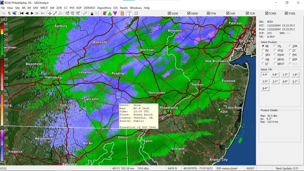
-
E PA/NJ/DE Fall 2024 Obs/Discussion
Hurricane Agnes replied to Rtd208's topic in Philadelphia Region
My high for the day ended up being just after midnight at 51 and the temps have been slowly falling since. Briefly got under a band and added another 0.2" to my day's total, for 0.85" for the day, and 1.39" for the 2-day event total so far. Currently 41 with dp 38. -
E PA/NJ/DE Fall 2024 Obs/Discussion
Hurricane Agnes replied to Rtd208's topic in Philadelphia Region
Looks like the low is hanging near or just off the Jersey coast and some bands are backing in with it. The doppler animation is kind of wild with the flows going in all different directions. Temps have dropped a degree here to 43 with dp 42 and overcast skies.- 1,105 replies
-
- 1
-
-
- tropics
- heavy rainfall
- (and 5 more)
-
E PA/NJ/DE Fall 2024 Obs/Discussion
Hurricane Agnes replied to Rtd208's topic in Philadelphia Region
Miracle of miracles. Rain. Had 0.54" before midnight, which was my highest daily total, literally since August 8 (when there was > 1/2"). After midnight resulted in another 0.61". After a pause, had been getting a round 2 for with another 0.04", for a daily total of 0.65" (so far) and a 2-day total of 1.19" at post time! Currently a misty 44, with the last of this round moving out, and dp 44.
-
E PA/NJ/DE Fall 2024 Obs/Discussion
Hurricane Agnes replied to Rtd208's topic in Philadelphia Region
Mt. Holly lofted a Wind Advisory for the lower tier of the CWA starting tonight - Hope your decorations are somewhat secure (might be hard with the inflatables). Made it up to 62 and it's currently 55 with dp 43.
- 1,105 replies
-
- 1
-

-
- tropics
- heavy rainfall
- (and 5 more)
-
E PA/NJ/DE Fall 2024 Obs/Discussion
Hurricane Agnes replied to Rtd208's topic in Philadelphia Region
Was seeing a billion "notifications" and finally got chance to get in here to check. Wasn't sure if it was due to the rare "liquid substance from the sky" or some actual or progged incoming "frozen substance from the sky" (given the WWA and Watches up for the northern CWA). I made it up to 59 yesterday after a low of 44, and had a low this morning of 49, with an amazing 0.04" of rain that happened sometime between 10 pm - 11 pm. In any case, looking forward to some actual soaking rain now. Will have to see where the triple point sets up and whether that generates anything convective. Haven't yet looked at the models but I know the GFS likes to spin stuff up before caving later... Currently partly cloudy and 59 with dp 48.- 1,105 replies
-
- 1
-
-
- tropics
- heavy rainfall
- (and 5 more)
-
E PA/NJ/DE Fall 2024 Obs/Discussion
Hurricane Agnes replied to Rtd208's topic in Philadelphia Region
Had some non-diurnal temp swings overnight where I bottomed out at 31 (first below freezing for me this season) just after midnight and then suddenly there was a (relative) warm-up between midnight and 1 am (could have been clouds that advected in and killed the radiational cooling), where the temp rose to the mid-30s and leveled out there the rest of the night. It's currently mostly cloudy and 39 with dp a dry 25.