Hurricane Agnes
-
Posts
9,336 -
Joined
Content Type
Profiles
Blogs
Forums
American Weather
Media Demo
Store
Gallery
Everything posted by Hurricane Agnes
-
E PA/NJ/DE Summer 2024 Obs/Discussion
Hurricane Agnes replied to JTA66's topic in Philadelphia Region
Getting lots of convection and some thunder and am under a heavier blob with >1.5"/hr rates. Currently have a total of 0.55" in the bucket at post time (which is 0.27" on top of the 2nd round, with 0.62 over the past 2 days). Temp made it to 88 for a high before the rains came in. Currently heavy rain and 76 with dp 73.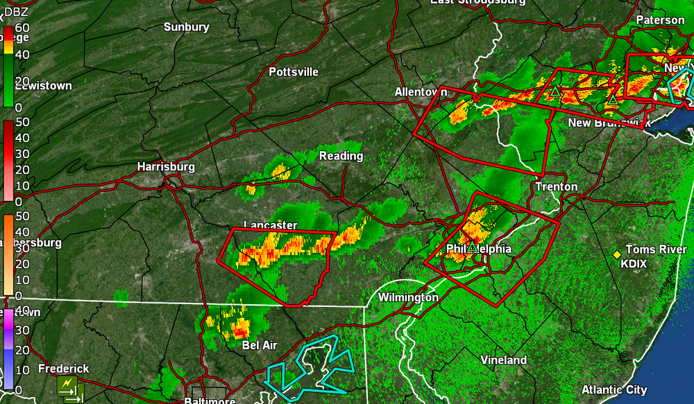
-
E PA/NJ/DE Summer 2024 Obs/Discussion
Hurricane Agnes replied to JTA66's topic in Philadelphia Region
ST Watches are up - The heaviest rain seemed to miss me to the north and south and I ended up with 0.07" before midnight and 0.28" after through post time so far (0.35" 2-day total). Bottomed out at 74 this morning and it's currently overcast and 78 with dp 77. -
E PA/NJ/DE Summer 2024 Obs/Discussion
Hurricane Agnes replied to JTA66's topic in Philadelphia Region
Reference -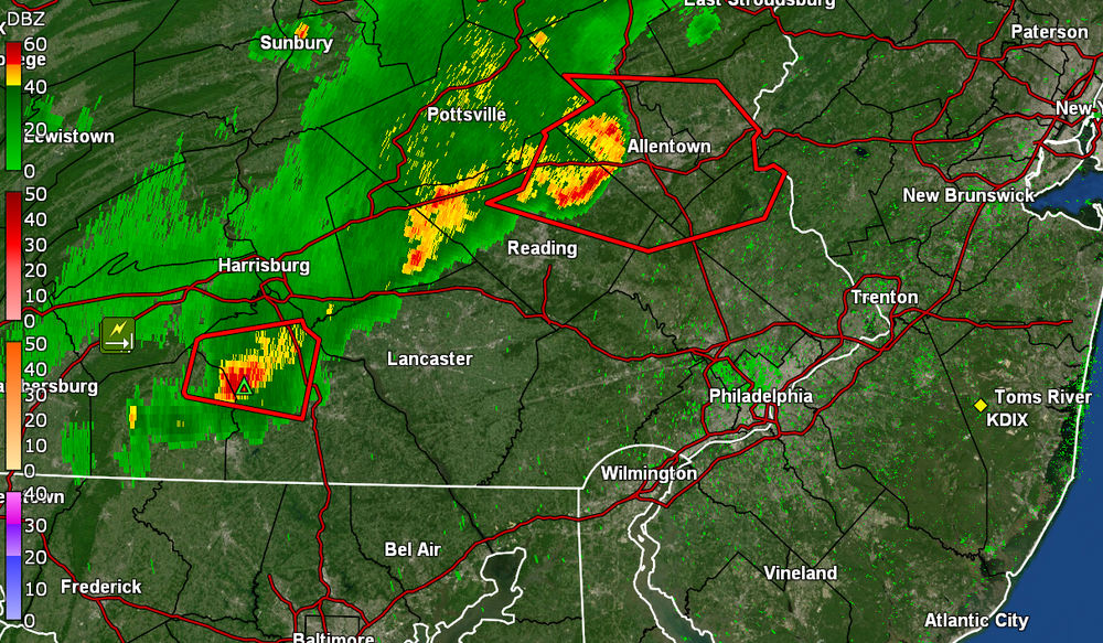
-
E PA/NJ/DE Summer 2024 Obs/Discussion
Hurricane Agnes replied to JTA66's topic in Philadelphia Region
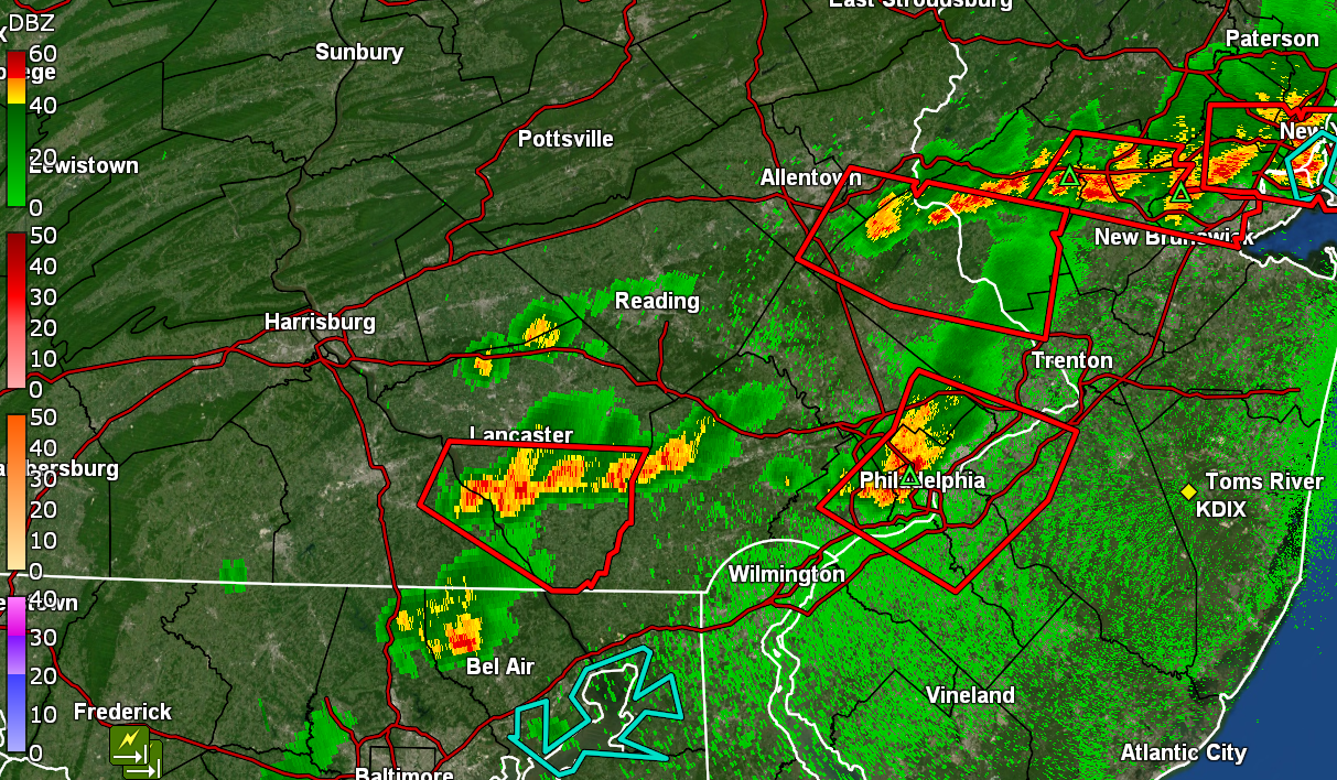
Beryl just got upgraded to a hurricane with the latest package.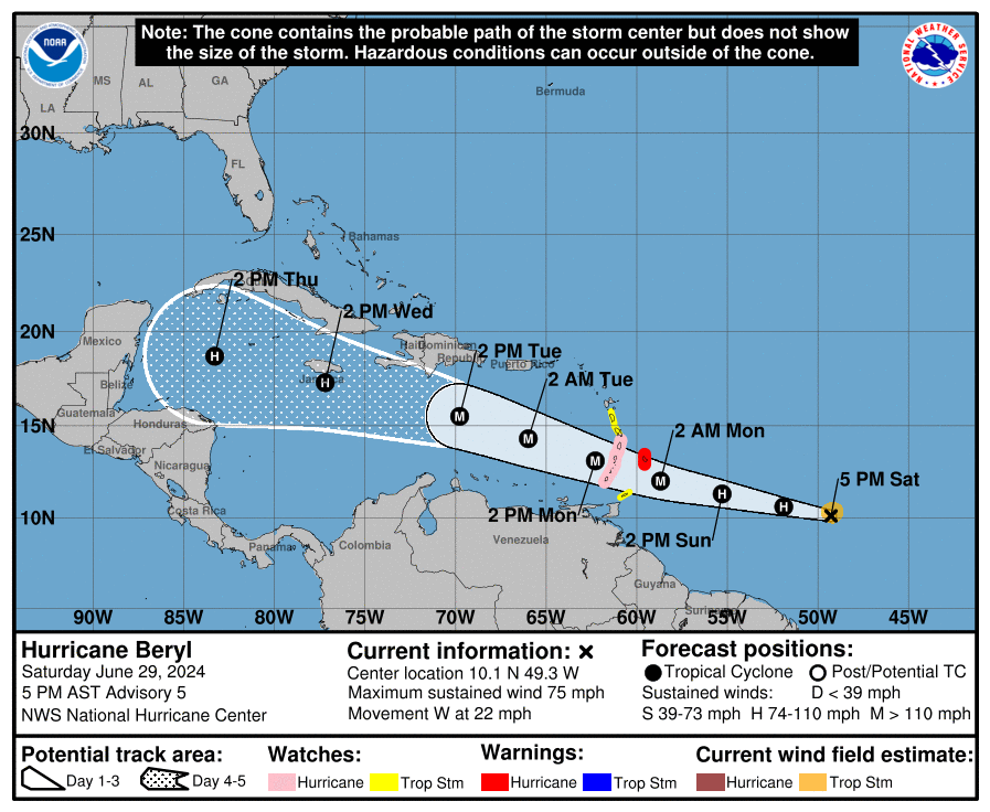
-
E PA/NJ/DE Summer 2024 Obs/Discussion
Hurricane Agnes replied to JTA66's topic in Philadelphia Region
Watches are up - It's pretty soupy out there. After a low of 65, I made it up to 88 so far today and it's currently overcast and 87 with dp 75. -
E PA/NJ/DE Summer 2024 Obs/Discussion
Hurricane Agnes replied to JTA66's topic in Philadelphia Region
Heard a lot of sound and fury overnight with a clarion call boomer at ~12:45 am. The overnight precip was a bookend of 0.09" before midnight and a whopping 0.25" after midnight. I won't complain compared to others as I have so far had 2.62" of rain for the month June. Currently a misty 68 with dp 67. -
E PA/NJ/DE Summer 2024 Obs/Discussion
Hurricane Agnes replied to JTA66's topic in Philadelphia Region
SPC just lofted the Watches - I went on and watered my plants this morning because I am thinking it will fizzle by the time it gets here. I did make it up to 94 as a high today with a mild low of 73. It's currently mostly cloudy and 90 with dp 73, , with junk and stuff off to the west. -
E PA/NJ/DE Summer 2024 Obs/Discussion
Hurricane Agnes replied to JTA66's topic in Philadelphia Region
Cold front has been moving through and what a difference. Currently mostly sunny and breezy, with some scattered fair weather cumulus and a temp of 80, where the dp is the big news - now down to 61! -
E PA/NJ/DE Summer 2024 Obs/Discussion
Hurricane Agnes replied to JTA66's topic in Philadelphia Region
Got 100 drops yesterday evening, so nothing measurable, but I did manage to get 0.06" early this morning between midnight and 2 am as a consolation prize. I'll take given much of the action was going on south of me. As a result of that rain, I ended up with a "low" of 74 just before 3 am but the temp bounced back up to my current of 77, with dp 69. Waiting for that cold front to come through for a brief respite. -
E PA/NJ/DE Summer 2024 Obs/Discussion
Hurricane Agnes replied to JTA66's topic in Philadelphia Region
Here we go - So far have hit 96 for a high and it's currently overcast, breezy, and 91 with dp 73. -
E PA/NJ/DE Summer 2024 Obs/Discussion
Hurricane Agnes replied to JTA66's topic in Philadelphia Region
Briefly tapped 96 just after 1 pm but the changeable hazy skies have been down to 94 currently with dp 76. -
E PA/NJ/DE Summer 2024 Obs/Discussion
Hurricane Agnes replied to JTA66's topic in Philadelphia Region
Just hit 95 here with dp 76. It was bopping around 94 for the past 10 minutes or so. -
E PA/NJ/DE Summer 2024 Obs/Discussion
Hurricane Agnes replied to JTA66's topic in Philadelphia Region
For the past couple hours, there was a hazy overcast with little sun poking through and that halted the temp rise at 86 during that time. The sun has now broken through and it's off to the races. Currently 89 with dp 77. -
E PA/NJ/DE Summer 2024 Obs/Discussion
Hurricane Agnes replied to JTA66's topic in Philadelphia Region
Ended up with a high of 96 IMBY at around 4:30 pm yesterday and my lightning detector had registered a bunch of strikes between 2 - 4 pm when some kind of pop-up came through to give my Wyndmoor sister about 15 minutes of a shower, which I would guestimate would have probably produced a couple hundredths of an inch. I didn't get anything measurable IMBY about 2 miles away, so was fringed by it in any case. It was still 86 here after 10 pm last night and this morning I have only dropped to my current 77 with dp 73, so I know it's steamy out. -
E PA/NJ/DE Summer 2024 Obs/Discussion
Hurricane Agnes replied to JTA66's topic in Philadelphia Region
Am at my Wyndmoor sister’s house and it’s raining. -
E PA/NJ/DE Summer 2024 Obs/Discussion
Hurricane Agnes replied to JTA66's topic in Philadelphia Region
I briefly hit 95 around 12:51 pm and JTA's cloud came overhead so I'm currently 94 with dp 76. ETA - strike that. The cloud kept moving so am back to 95 with dp 77. -
E PA/NJ/DE Summer 2024 Obs/Discussion
Hurricane Agnes replied to JTA66's topic in Philadelphia Region
Here it is just after 10:30 am and I hit 90 (89.8 @ 10:28 am). Currently mostly sunny and 89 with dp 77. -
E PA/NJ/DE Summer 2024 Obs/Discussion
Hurricane Agnes replied to JTA66's topic in Philadelphia Region
Whenever DIX is down, I'll usually switch to KDOX. The "look" is obviously shifted a bit from DIX but works. I ended up with a 74 low before it rebounded back up again. Currently mostly sunny and 86 already, with dp 76. -
E PA/NJ/DE Summer 2024 Obs/Discussion
Hurricane Agnes replied to JTA66's topic in Philadelphia Region
Popped outside this morning to throw some water on an urn out front that I have planted with some drought-tolerant plants - a rubra grass and some portulaca and OMG it was pretty rough out there and we're talking around 5 am-ish. I ended up with a high of 94 yesterday and the temp was still 84 at 9 pm last night IMBY. It's currently a steamy 74 with dp 71. -
E PA/NJ/DE Summer 2024 Obs/Discussion
Hurricane Agnes replied to JTA66's topic in Philadelphia Region
So far I have hit 94 IMBY as a high but am currently a mostly sunny 92 with dp 72. -
E PA/NJ/DE Summer 2024 Obs/Discussion
Hurricane Agnes replied to JTA66's topic in Philadelphia Region
I hit 91 just after noon today and am currently mostly sunny and bopping between 91 & 92 with dp 73 ("Feels like" is 100). -
E PA/NJ/DE Summer 2024 Obs/Discussion
Hurricane Agnes replied to JTA66's topic in Philadelphia Region
I remember seeing my first lanternfly out your way so who knows? You might be lucky! I managed to tap 92 yesterday for a high and this morning was a bit warmer than the previous two with a low of 70. Currently mostly sunny and 80 with dp 71. -
E PA/NJ/DE Summer 2024 Obs/Discussion
Hurricane Agnes replied to JTA66's topic in Philadelphia Region
Have hit a day 3 of 90 and above, with Tues. @92, yesterday at 91, for my first "official" heatwave of the summer. And happy summer solstice. Days will eventually get shorter. Surprisingly, my low was 67 this morning, which was lower than the past couple days' lows. Currently partly sunny with lots of cumulus and 88 with dp 70. -
E PA/NJ/DE Summer 2024 Obs/Discussion
Hurricane Agnes replied to JTA66's topic in Philadelphia Region
Eww - after a low of 70 this morning, I have currently hit 92 with dp 75 and weather station "Feels like" of 104. I haven't set foot outside today (yet). The dp had actually spiked to 77 at some point today. Will have to see how things cool off tonight. -
E PA/NJ/DE Summer 2024 Obs/Discussion
Hurricane Agnes replied to JTA66's topic in Philadelphia Region
I don't think you could have beat last weekend for low humidity and warm temps as well as a breeze. I was at a HS graduation this past Saturday for one of my nieces that was held at Millersville U in Lancaster County and it was a gorgeous day for it. But that weather is all history now. Started off today with a low of 65 and reasonable dews in the low 60s but even that is also history. I expect 88 will be my eventual high for today. It's currently the triple Hs - a hazy, hot, and humid 87, with lots of cumulus and a dp of 72.