Hurricane Agnes
-
Posts
9,344 -
Joined
Content Type
Profiles
Blogs
Forums
American Weather
Media Demo
Store
Gallery
Everything posted by Hurricane Agnes
-
LOL Someone was reading the thread. SPC is up with TOR Watches.
-
WPC 11 am update (now extratropical, moving ENE at 25 mph, winds and pressure steady) -
-
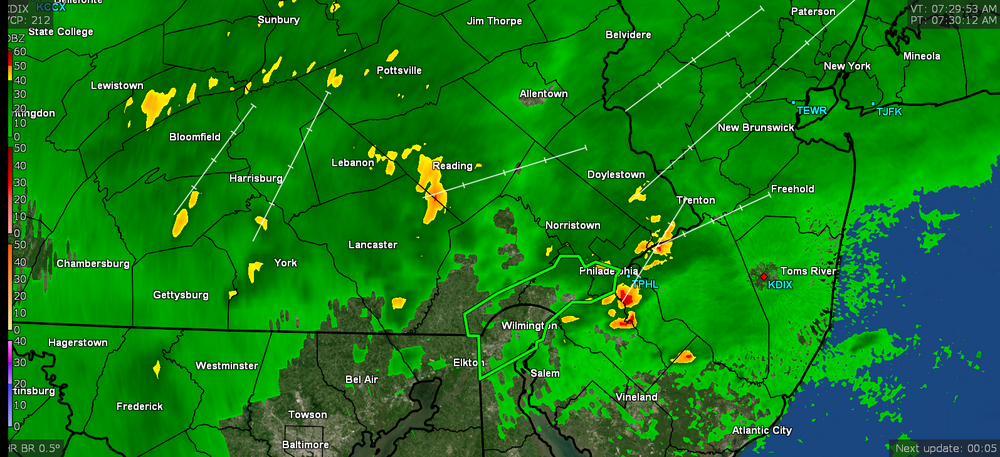
Here's what Mt. Holly had to say about that - It's gonna probably depend on the position of the front (whether or how far north it lifts as a warm front) and any other dynamics going on in the area that might not be directly related to Ida itself, that I expect is more on the mesoscale level with localized pop-ups that rain themselves out over certain spots.
-
There are some blobs of convection associated with the storm that have been cutting across VA and MD and generally going to the NE, along with the wider band that is funneling to the NW, so we might get something out of the southern blobs.
-
WPC just got real - From NWS MARFC -
-
I can smell that stew all the way down here! Some holes opening in the precip field near me so the rain has stopped for the moment but am at 0.56" so far this morning with temp now down to 68 (so far my low for the day) and dp 68.
-
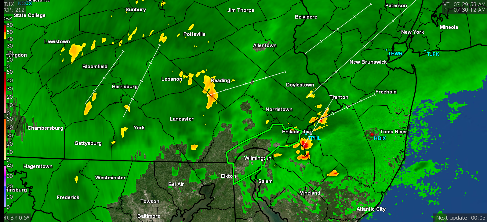
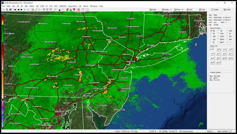
Just tweeted from Mt. Holly - I was hopping around literally a pile of radar sites and they are all solid with returns (KRLX, KPBZ, KLWX, KCCX, KDOX, and of course KDIX).
-
I've been getting some light rain since before 4:30 am and am already up to 0.49" here in NW Philly. It's just getting started
-
The first of the antecedent Ida rain is hitting here (started just before 4:30 am) and am up to 0.02" so far. Ended up with 11.02" of rain for the month of August, 20.70" of rain and 32 days at or above 90 for the meteorological summer (JJA). High for yesterday was 85 and I'm currently at 70 with light rain and dp 68.
-
WPC 5 am update (strengthened a bit to 30 mph but now a more weak low at 1000 mb, and has now been officially caught in the flow and rolling at 24 mph to the NE) -
-
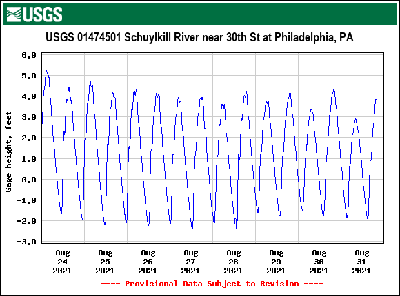
That's just fascinating!!!! I'm glad a new gauge was put there. Since they have developing all around that area from 25th St. down to the 30th St. corridor (e.g., "Schuylkill Banks" and the pedestrian walkways, etc. running along the river), I expect that monitoring flooding right around there is critical.
-
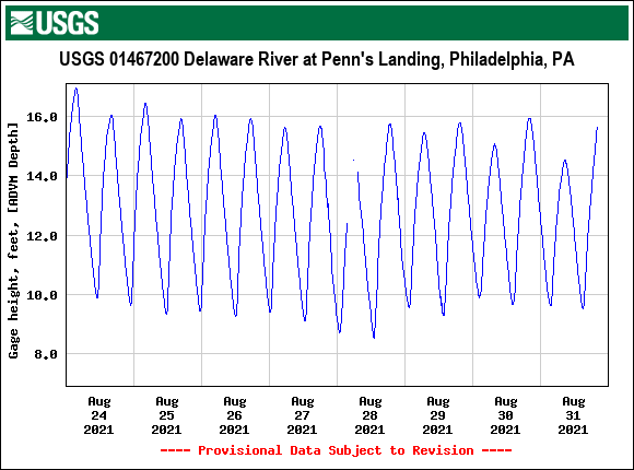
Now this is cool - the Schuylkill has a new gauge at 30th St (retweeted by Mt. Holly)! I usually like looking at USGS's page, which for this new gauge is here - https://waterdata.usgs.gov/nwis/uv?site_no=01474501 Kinda cool to see the gauge readings and it was looking like it was actually tidal (the one on the Schuylkill across from the Waterworks doesn't do that) and wasn't sure if that was what I was actually seeing until I looked at the Delaware River one (the deeper one at Penn's Landing) and saw a matching pattern, and I know the Delaware is tidal.
- 487 replies
-
- 1
-

-
- hurricane
- flooding potential
- (and 2 more)
-
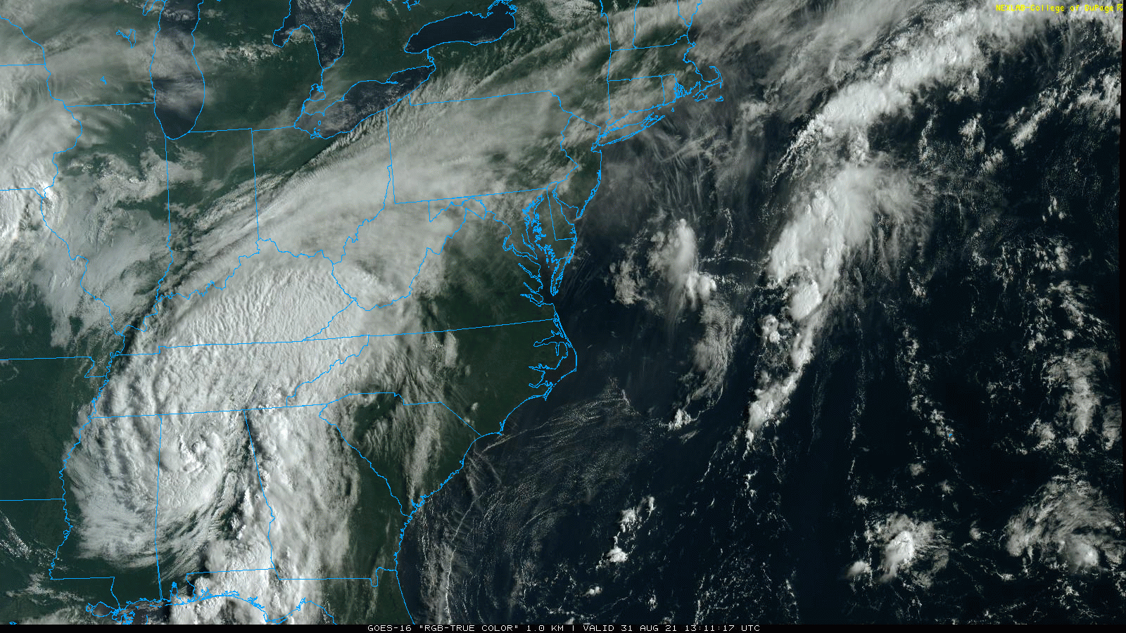
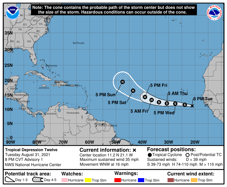
WPC 5 pm update (winds have dropped, pressure has risen, and movement has increased to 17 mph as it gets drawn to the NE as a huge rainstorm) - I did see some mention about the conditions possibly causing it to strengthen a bit as it moves closer to the area... I also saw that TD-12 has formed and if it gets named, it will be "Larry". It's way way over just south of Cape Verde.
-
SPC just penciled in some of Philly metro for "enhanced risk" for their SWDY2 from Ida - It'll depend on where that front situates itself. So far I've hit a high of 85 today whenever the sun popped out but it inevitably self-destructs and the temp drops (with the wobbly movement of the front). Am currently 83 and overcast with dp 66 so the front has dropped slightly south of me at the moment.
-
Mt. Holly retweeted the SWD2 from SPC that just put some of Philly metro into the "enhanced risk" category for severe (which tends to be rare for them to do for our area) -
-
LOL I don't think I'll ever forget Floyd. We were let out of work early and it took me 3 hours navigating around the flooded city streets to go the 12 miles to get home.
-
WPC update (deepened a bit to 996, sped up to 15 mph so getting caught in the flow, but steady motion to the NE) -
-
Got a text about the Schuylkill possibly hitting minor flood stage at the mouth and moderate at Norristown (that I saw earlier). Mt. Holly also posted this - I know it won't take much to send the Wissahickon out of its banks (and that feeds the Schuylkill from little creeklets in the watershed where I am).
- 487 replies
-
- 1
-

-
- hurricane
- flooding potential
- (and 2 more)
-
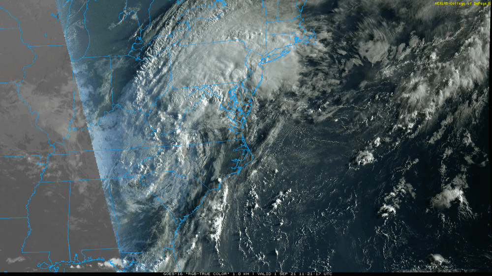
The 5 am WPC update (posted right after my last update - down to 30 mph, same heading but sped up to 12 mph) - Still a swirling mass of precipitation and starting to send some cloud plumes up over PA.
-
The 88 ended up being my high for yesterday and despite some early overcast and then some clearing and sun, it has clouded over again with a deck of high clouds, and is currently 77 with dp 70, which is a slight drop previously. So the cold front is hovering just overhead and where that eventually sets up, will probably determine where the Ida remnants go... On a side note, yesterday I heard KYW do a quicky "beach report" mentioning the ocean temperatures being between 79 - 83 yesterday. I know this is the warmest time of year for the oceans at the shore but that is approaching GOM temps and it seems to be more consistently doing that in recent years.
-
SPC has parts of the southern 1/3rd of the CWA in the "marginal" and "slight risk" for severe in SWD1 & SWD2 -
-
NWS MARFC (as of yesterday evening) calling for near to minor river flooding for locations within the CWA - Mt. Holly event summary (posted last night) -
-
WPC 11 pm update (holding steady at 35 mph, pressure deepend a bit to 998, moving 10 mph to NE) - Entire Mt. Holly CWA in WPC Day 2 "moderate risk" for excessive precipitation -
-
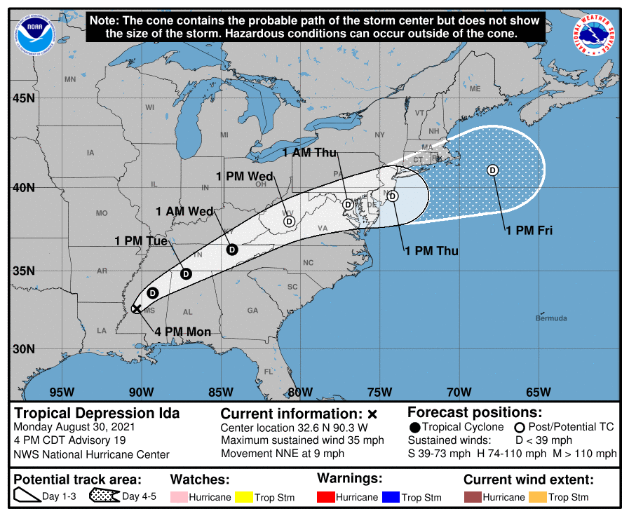
NHC 5 pm update (Ida now downgraded to a tropical depression, 35 mph, 999 mb, movement unchanged 9 mph NNE) -