Hurricane Agnes
-
Posts
9,350 -
Joined
Content Type
Profiles
Blogs
Forums
American Weather
Media Demo
Store
Gallery
Everything posted by Hurricane Agnes
-
NHC 5 pm Advisory (now-post tropical, down to 25 mph, ENE 9 mph, pressure steady) - And it is still sending moisture down here to us!
-
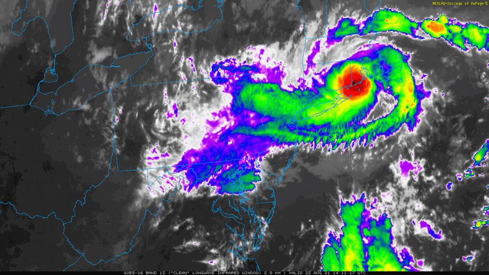
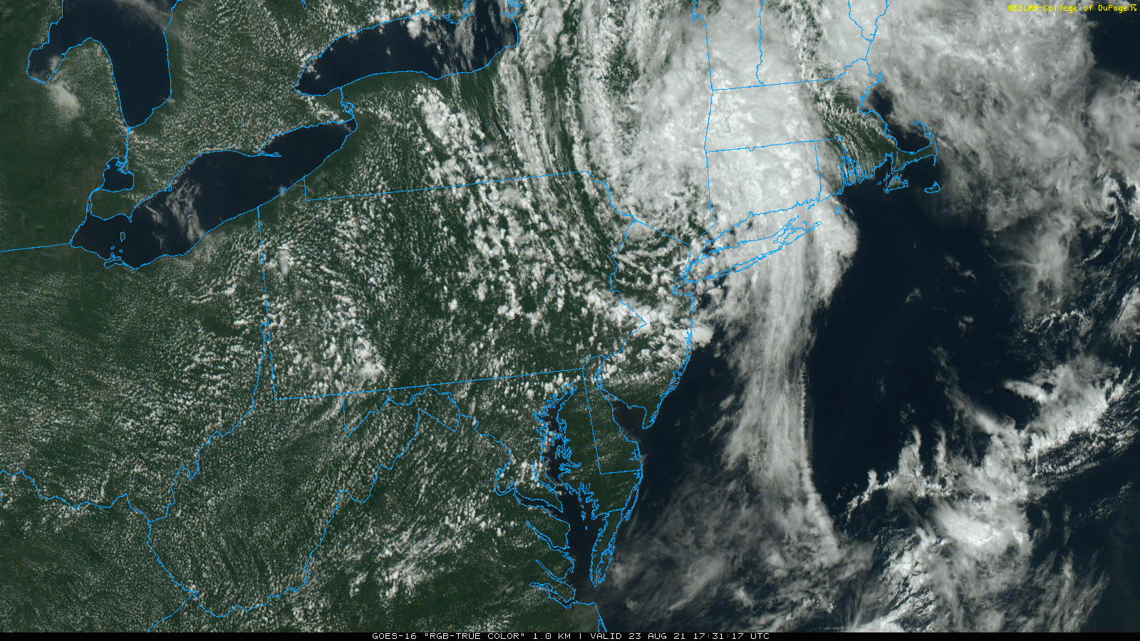
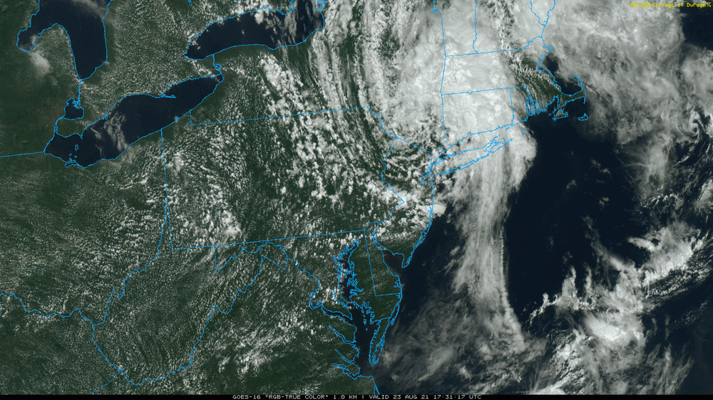
You can see the naked swirl from Henri sitting right on the NY/NJ/PA border. The cloud structures have really spread out and you can see the band that is producing that convection.
-
They seemed to have popped up out of nowhere and are surfing the Henri waves!
- 216 replies
-
- 1
-

-
- hurricane
- tropical storm
- (and 2 more)
-
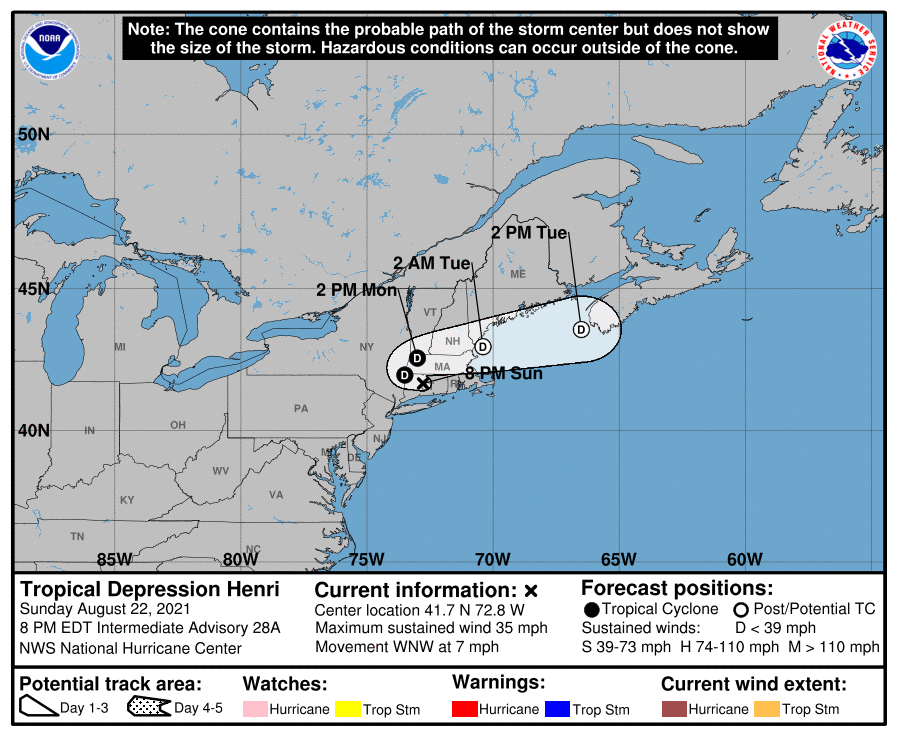
New NHC update after claiming the last was a final - (the stalled system has started moving again and is now moving east at 6 mph, with all other parameters steady) -
-
You just made me look and it's 84 here now with dp 76, so here we go! The sun has been popping in and out but it's definitely unsettled.
-
Before the sun briefly popped out this morning and self-destructed, I ended up with a total of 0.45" from the band. Total for the 3-day event is now at 1.97". It looks like the rain band that pivoted through has pretty much dried up here and is mostly off the coast, although if the temps do recover with any clearing and sun, I wouldn't rule out any popups. The low this morning was 71 and I'm currently @ 74 and overcast, with dp 73. ETA - and with the clouds came some light rain since my above - enough to wet the walks. Not enough to tip the bucket yet and not really showing up on the radar, but I suppose the atmosphere must be wringing itself out.
-
Getting TD Henri 3rd round, with 0.1" just before midnight, adding to my earlier 1.44" from yesterday, and now 0.33" more at post time (total 1.85"). Currently light rain with temp is 71, dp 71, and steamy windows.
-
NHC 5 am FINAL Advisory (now stalled drifting E 1 mph, weakened to 1005 mb, and 30 mph winds) -
- 216 replies
-
- 1
-

-
- hurricane
- tropical storm
- (and 2 more)
-
I think some of the models earlier in the week suggested that it would drift to the west and get cut off from any steering mechanisms (basically sitting and raining all over the place), to the point where a couple mets were even comparing it to what Hurricane Harvey did (down in Texas). It would supposedly eventually get picked up by something and sent east again across NE, and out to sea. Some of the models even had it do a loop-de-loop that took it down into NE PA, and then had it head back up to the northeast, and finally go east out to sea. The behavior we are seeing probably had the most uncertainty with the forecasting because it was dependent on features to the north and the ULL that is south of where we are, that would be determinants on its movements.
- 216 replies
-
- 1
-

-
- hurricane
- tropical storm
- (and 2 more)
-
NHC 8 pm Advisory (now downgraded to a Tropical Depression, winds 35 mph, pressure 1000 mb, but still moving at 7 mph WNW) -
-
My low ended up being 71 this morning, just after 7:30 am and I did finally make it to 80 about 2:45 pm when that dry slot was trying to provide some breaks for the sun to peak through, although it didn't really make it, but the sky didn't brighten briefly. Currently 75 and overcast with dp 73.
-
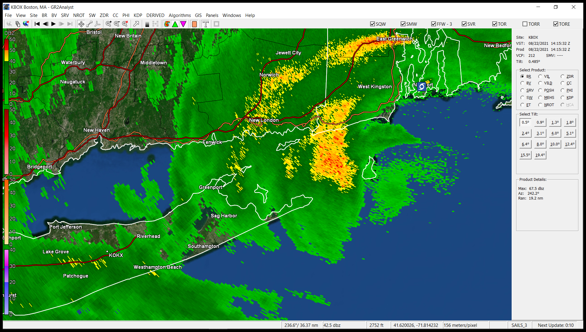
I've been watching some returns slowly dropping down to your area although it might be virga at this point.
-
When I got my Ambient weather station, I had been reading all sorts of discussions on how people calibrate all sorts of rain gauges and saw pics of those ASOS rain gauges. I think the point of the slats is as a baffle around the funnel to minimize ground level winds and droplet bounce, since the rain can get blown around that could miss the gauge and give readings that are too low. There's a cool little video explanation of it (using NWS's DFW ASOS as an example) -
-
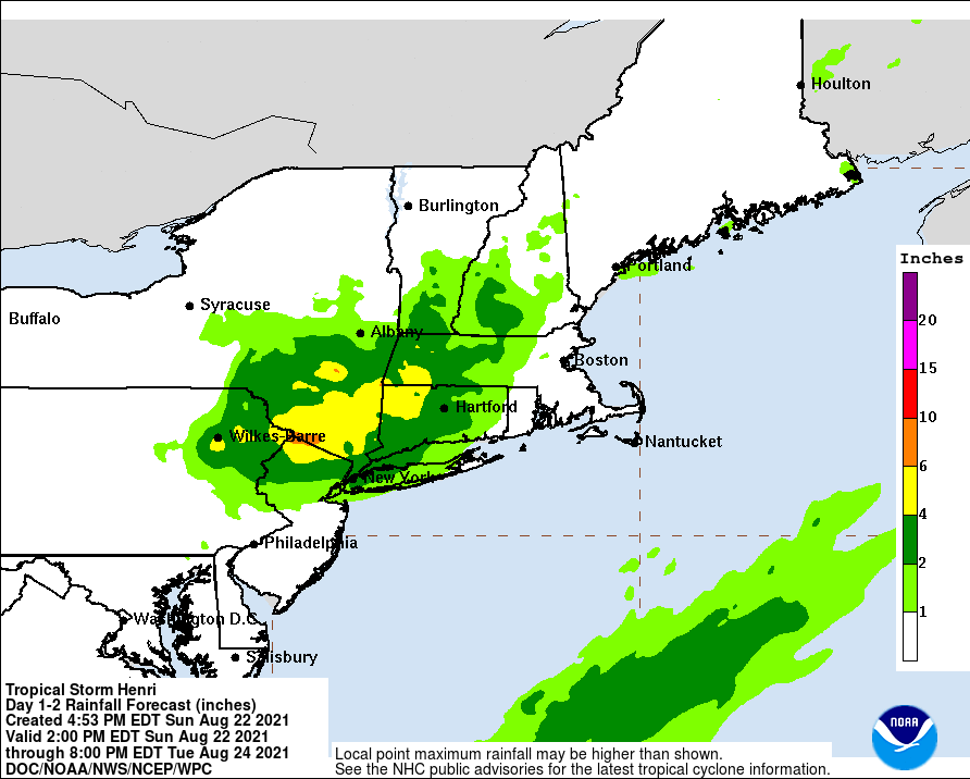
Mt. Holly has a forecast rain band pivot for the CWA overnight and into tomorrow morning, so it's possible, if it verifies, that anyone who missed out the first round, might cash in on a 2nd round (including what looks like a convective line tomorrow morning) -
-
Well if it came out of their ASOS there, it was automated. I know that KNYC (Central Park) has always been made fun of (temperatures and snow measurements) and I always wondered if they normally bypass it and use KJFK for official readings for NYC. I found a pic of the little complex of instruments so it could be a tree issue - https://www.weather.gov/okx/CentralParkHistorical I think the funky slatted unit on the left is their rain gauge/ASOS.
-
They broke a record in Central Park last night right when they had (stupidly) went on with that concert there and then had to halt it about halfway through and cancel the rest because of --> WPC actually still has part of SE PA as Marginal for their Day 2 -
- 216 replies
-
- 1
-

-
- hurricane
- tropical storm
- (and 2 more)
-
NHC 5 pm Advisory (weakened to 40 mph sustained, speed slowed to 7 mph and now moving WNW, with pressure up to 997 mb) -
-
NHC's 2 pm update (storm down to 50 mph sustained, has slowed to 9 mph, moving NW, and weakened to 991 mb) -
-
Hurricane Bob in 1991 (although Bob was much stronger than Henri) - https://www.weather.gov/mhx/HurricaneBob1991EventReview https://www.weather.gov/box/hurricane_bob And interestingly enough, it almost looks like a similar rainfall pattern too, although the track was a little different (not the Harvey-like getting cutoff and stall before moving out that seems to be progged for Henri) -
- 216 replies
-
- 1
-
-
- hurricane
- tropical storm
- (and 2 more)
-
The fire hose flow is just bizarre. It is spraying moisture from NY, NNW across NNJ and NEPA, and literally all the way out to central PA, where it starts "falling" (dropping) south, and then recurving around to the SE down into MD and across central DE. There's a big hole in between. It's like a giant hook or a hot wheels track or something.
- 216 replies
-
- 2
-
-
- hurricane
- tropical storm
- (and 2 more)
-
NHC 12:30 pm update - LANDFALL in Western RI approx. 12:15 pm -
-
A bunch of the NNJ folks have been posting in the NY Metro forum.
-
Mt. Holly's 24 hr precip estimate (as of 8 am, posted 9:13 am) - You can see the sharp cutoff - ETA - I am currently 1.44" for the day so far (1.51" for the 2 day event at post time).
-
NHC 11 am update (weakening and down to 60 mph, at 987 mb, and slowing to 12 mph -
-
Looks we are at or close to landfall in RI. It's hard to tell (at least on doppler) due to all the convection.