Hurricane Agnes
-
Posts
9,342 -
Joined
Content Type
Profiles
Blogs
Forums
American Weather
Media Demo
Store
Gallery
Everything posted by Hurricane Agnes
-
The sun has been peaking through the haze and the temp recovered to 82 here. But the dp is now 80. I noticed that the current pop-ups have literally been stationary. There doesn't seem to be anything to move them along and they eventually fizzle out.
-
Ended up with 0.08" from getting fringed from a pop-up but it knocked the temp down to 79 now with dp 76.
-
Getting some light rain from a pop-up moving in from the WSW here. So far has tipped the bucket at 0.01". The radar is picking up some wierd out flow boundaries expanded from all sides of the city. Temp is knocked down to 87 but kicked the dp up to 78.
-
You wait till Ida gets up here. She just got her "hurricane wings". I managed to tie my high for the summer so far (93) before dropping back to a current 89 with dp 76. The cirrus had started streaming a couple hours ago and now the cumulus are coming in with stuff starting to pop.
-
I had a 75 low this morning and watched the little pop-ups form and go east of me last night. I figured I could hold off okay given they are forecasting flood-watch type of rain over the next couple days. We shall see. Hit 90 about an hour and a half before noon (#35 since May & #32 for JJA) and currently 90, with dp 77.
-
Looks like TS Ida is here - It may have some rain impact here some time next week moving along a front and we have had a couple "I" storms over the years that had some significant impact on the CWA - e.g., Isabel (2003), Irene (2011), Isaias (2020).
-
So far my high for today has been 93 (#34 since May and #31 for JJA). Currently partly sunny and 92 with some angry cumulus, and a dp. bopping between 76 and 77.
-
My low this morning was 73. I thought I saw the dp was supposed to "mix out" but it sure as hell is sitting at 77 with a current temp of 89, and having gone to the store early this morning, it was definitely noticeable... although I suppose I have slowly adjusted to it somewhat.
-
Made it up to 93 too as a high, right around 2:45 pm. Low was 70 this morning and it's currently 91 with dp 69 and the cumulus have returned to dot the sky!
-
Have hit 90 for a #32 of 90s and above since May (#29 for the J-J-A meteorological summer) just before 2pm. Currently 90 and all blue sky, with dp 70 (and you can definitely feel the heat out there). Hopefully the 5.64" of rain that I had the past 5 days will hold through this upcoming heatwave.
-
My low this morning was a "warmer" 73 and it's currently all blue sky and 87 with dp 73.
-
WPC 5 am Advisory (continues moving east, has sped up to 14 mph, and weakened to 1007 mb - expected to dissipate within 24 hrs) -
-
The 2.12" was my final Henri event total and with that, I am now up to an incredible 8.97" for the month of August, with a 3.45" 8/19 deluge being the highest 1-day rainfall for the month to date (and 35.06" for the year to date). Am currently 73 with dp 71.
-
From Mt. Holly - The models that showed it loop-de-loop right into NNJ were SPOT ON! HUGE PNS (as of 3:37 pm) -
- 216 replies
-
- 1
-

-
- hurricane
- tropical storm
- (and 2 more)
-
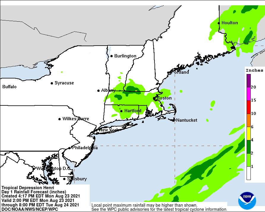
Latest WPC rainfall forecast - done in this area.
-
Got under a couple pop-ups that gave me an additional 0.15" so far, bringing my total to 2.12" for the event. Those Henri bands just keep on giving!
-
Henri + humid unsettled air has generated yet another round of rain here. Have picked up and addition 0.15" in showers so far bringing my total to 2.12" for the event. I made it up to 88 today, which due to the rain, was probably going to be it as my high. Currently 78 and misty, with dp 75 and yup - the steamy windows flags are up.
-
NHC 5 pm Advisory (now-post tropical, down to 25 mph, ENE 9 mph, pressure steady) - And it is still sending moisture down here to us!
-
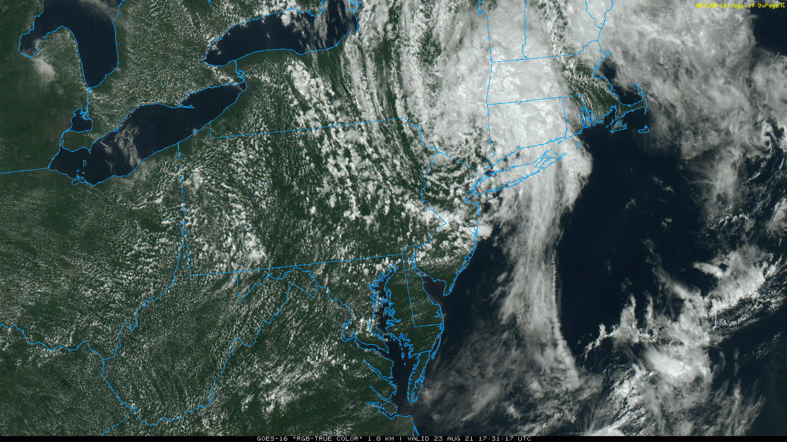
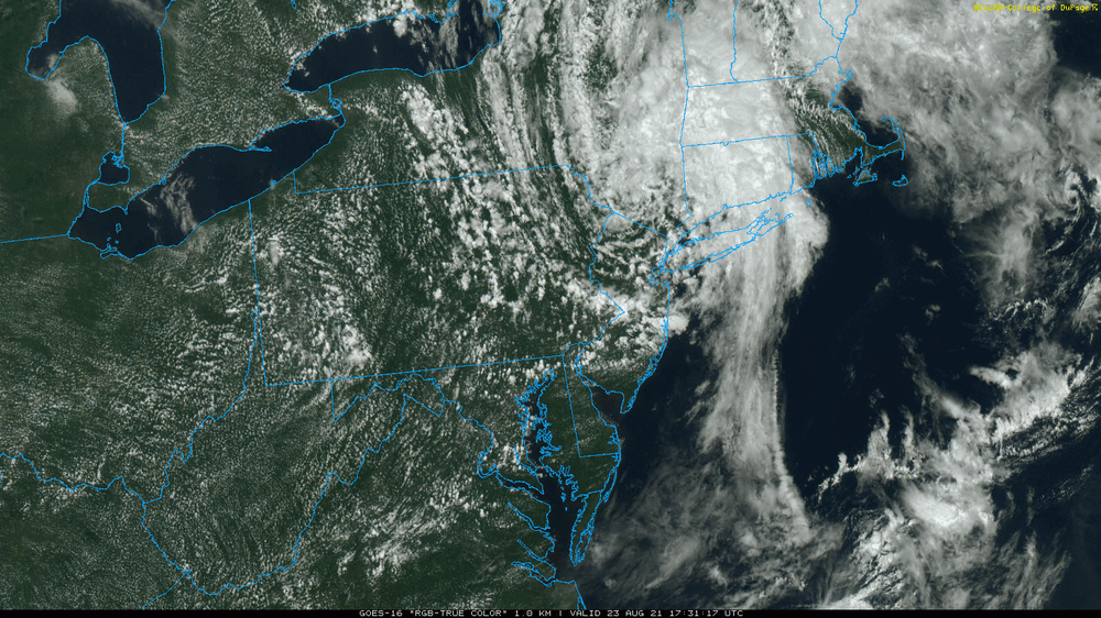
You can see the naked swirl from Henri sitting right on the NY/NJ/PA border. The cloud structures have really spread out and you can see the band that is producing that convection.
-
They seemed to have popped up out of nowhere and are surfing the Henri waves!
- 216 replies
-
- 1
-

-
- hurricane
- tropical storm
- (and 2 more)
-
New NHC update after claiming the last was a final - (the stalled system has started moving again and is now moving east at 6 mph, with all other parameters steady) -
-
You just made me look and it's 84 here now with dp 76, so here we go! The sun has been popping in and out but it's definitely unsettled.
-
Before the sun briefly popped out this morning and self-destructed, I ended up with a total of 0.45" from the band. Total for the 3-day event is now at 1.97". It looks like the rain band that pivoted through has pretty much dried up here and is mostly off the coast, although if the temps do recover with any clearing and sun, I wouldn't rule out any popups. The low this morning was 71 and I'm currently @ 74 and overcast, with dp 73. ETA - and with the clouds came some light rain since my above - enough to wet the walks. Not enough to tip the bucket yet and not really showing up on the radar, but I suppose the atmosphere must be wringing itself out.
-
Getting TD Henri 3rd round, with 0.1" just before midnight, adding to my earlier 1.44" from yesterday, and now 0.33" more at post time (total 1.85"). Currently light rain with temp is 71, dp 71, and steamy windows.
-
NHC 5 am FINAL Advisory (now stalled drifting E 1 mph, weakened to 1005 mb, and 30 mph winds) -
- 216 replies
-
- 1
-

-
- hurricane
- tropical storm
- (and 2 more)