Hurricane Agnes
-
Posts
9,354 -
Joined
Content Type
Profiles
Blogs
Forums
American Weather
Media Demo
Store
Gallery
Everything posted by Hurricane Agnes
-
Another just heard on KYW - The tornado that didn't pay a toll going over the Burlington-Bristol bridge was confirmed as an EF1 -
- 487 replies
-
- 2
-

-

-
- hurricane
- flooding potential
- (and 2 more)
-
Just heard on KYW that the Montco tornado was confirmed as an EF2. Mt. Holly tweet -
- 487 replies
-
- 3
-
-
-
- hurricane
- flooding potential
- (and 2 more)
-
It is a PITA when it comes to anything to do with "water" and "flooding" because they'll say you need "flood insurance" (which is basically only offered by the government via whoever they use). It comes down to how the damage is described and worded. Really really sorry to hear that you got walloped multiple times where you live. Wishing you luck for whatever you decide to do.
- 487 replies
-
- 1
-
-
- hurricane
- flooding potential
- (and 2 more)
-
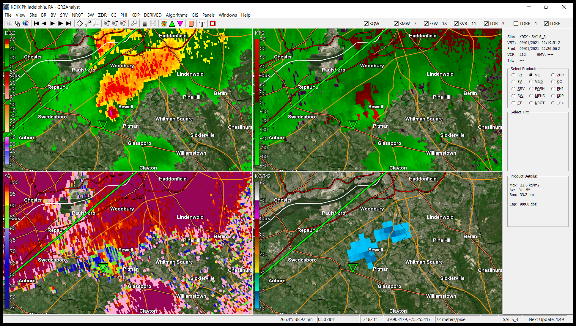
I had posted a 4-panel combo of different views (including the CC) from my GR2Analyst of it earlier in the thread. Have been wanting to capture a 3-D volumetric of one (kinda tricky to get since they aren't always on the ground that long around here).

- 487 replies
-
- 1
-
-
- hurricane
- flooding potential
- (and 2 more)
-
I think pretty much all of us would give them major props for warning about this event - both the tornadoes and flash floods. One of my former co-workers alerted to a tweet by someone who was staying in a hotel in Ft. Washington, PA where a suspected tornado occurred and had some video from his perspective from the hotel bathroom - Also found another with a different view of the Mullica Hill tornado -
- 487 replies
-
- 3
-
-

-
- hurricane
- flooding potential
- (and 2 more)
-
I can image. They are going to have to maybe run big dredger pumps to get some of that water out of there. I know there are drains along the road but a this point, they are obviously clogged with mud and debris. Geez.
-
Mt. Holly tweeted about the Mullica Hill tornado and the radar presentation - I'm still learning what to look for in the different radar products so this is great...
- 487 replies
-
- 4
-
-
-
-
- hurricane
- flooding potential
- (and 2 more)
-
Wait, but there's more - What looks like a "canal" or small "river" in the above pic is actually the ROADWAY for the Expressway that is under water (it is below street level with numbered streets that cross over it at intervals). This is what it normally looks like -
- 487 replies
-
- 3
-
-
-
- hurricane
- flooding potential
- (and 2 more)
-
I literally used that every morning going to work. From where I am in Chestnut Hill, my whole route was along creeks (Cresheim, Wissahickon) and rivers (Schuylkill and finally to my office 2 blocks from the Delaware River). That's why the last time it was like that during Floyd, I had to use Broad Street up most of the way north and then cut over through Germantown going west... and then try to find a few high and dry streets to get home. Took 3 hours for what would normally be a 30 minute (no traffic) to 45 minute (during heavier rush hours) trip to do the route.
- 487 replies
-
- 1
-
-
- hurricane
- flooding potential
- (and 2 more)
-
I just found this - the entrance to the Vine St. Expressway at 22nd St. (going eastbound) coming off of both the little ramp from the Ben Franklin Parkway and from I-76 (Schuylkill Expressway) - Apparently the "Logan Square" neighborhood that is adjacent to that was flooded, including the brand new Giant Supermarket near there at ~23rd and Cherry St.
- 487 replies
-
- 2
-

-
- hurricane
- flooding potential
- (and 2 more)
-
Was looking for something else and found this yikes! I think the first image in the video is the waterfall on the Schuylkill near the Waterworks, the 2nd is that Schuylkill River trail, am guessing the 3rd was done maybe from a boat going under the main bridges going over the Schuylkill downtown (e.g., Market St., Chestnut St., Walnut St., etc), not sure where the 4th was unless it was somewhere in Manyunk, and the 5th is insane - that is the Vine St. Expressway (I-676) that runs parallel to Vine St. "local", and is beneath the street level (with numbered streets going overhead, which I think are those from 21st down to 6th St - I used to use it eastbound to commute to work every day in the mornings, but never the afternoons) - that was apparently completely flooded.
-
My low actually dropped to 60 this morning and am currently mostly sunny and 67 with dp 57.
-
WPC preliminary precipitation totals for 9/1 - 9/2/21 -
- 487 replies
-
- 1
-
-
- hurricane
- flooding potential
- (and 2 more)
-
I saw the pics of the water pouring into the subway stations and over the moving subway cars like waterfalls. I really don't know what one can do about that happening other than finding some way to "cover" every station stairway, which is impossible.
- 487 replies
-
- 1
-
-
- hurricane
- flooding potential
- (and 2 more)
-
Mt. Holly tweeted a map of where they plan to investigate suspected tornadoes -
-
You all looked like you had a rain band just training over that area for hours.
-
I already did not long after midnight. Literally out within 15 minutes when I did. Got up at ~4:45 am. Being retired = being able to take a nap whenever I want during the day.
- 487 replies
-
- 3
-

-
- hurricane
- flooding potential
- (and 2 more)
-
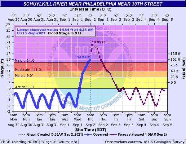
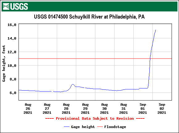
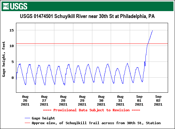
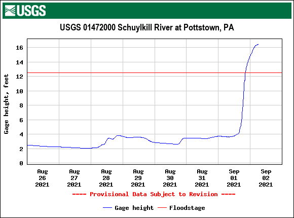
NWS MARFC retweeted KYW coverage - As a comparison - this was a pic of the same location (this is around 30th Street Station) at around 2 am (this is where the Schuylkill Expressway goes under the street level along the river) - If the level hits the progged 19 ft. that may put the Schuylkill Express way shown above, under water.
- 487 replies
-
- 1
-
-
- hurricane
- flooding potential
- (and 2 more)
-
WPC 5 am update (no change in winds, pressure, forward motion) -
-
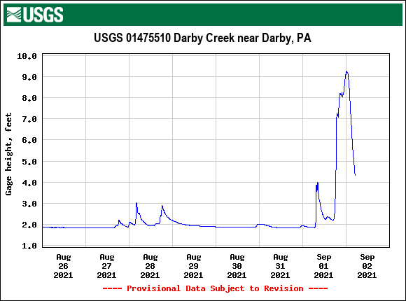
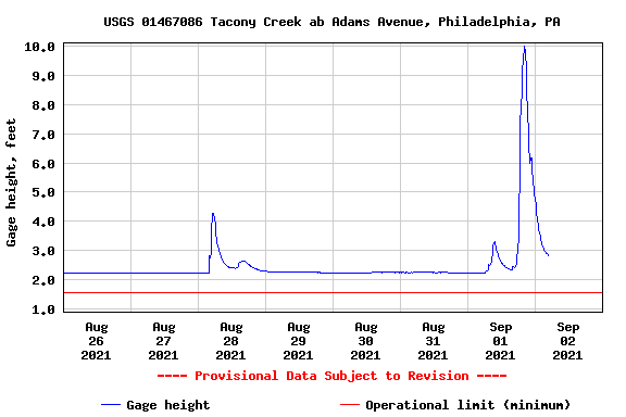
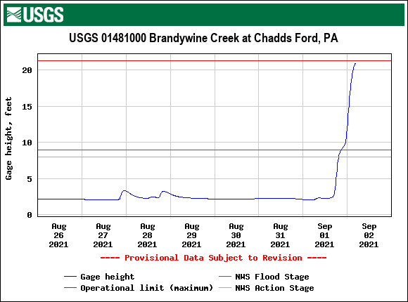
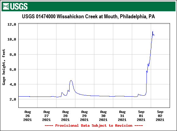
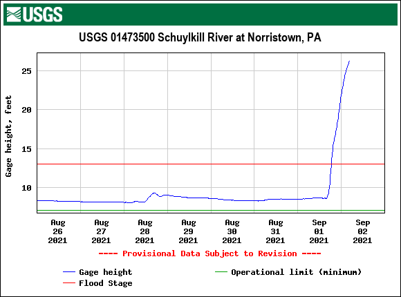
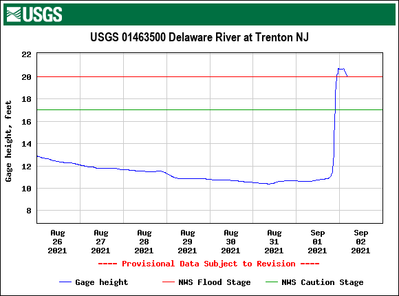
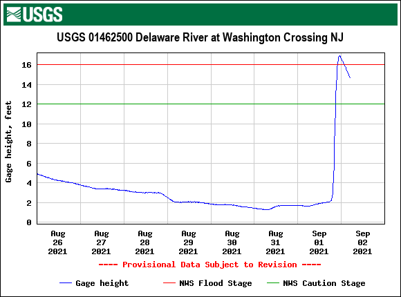
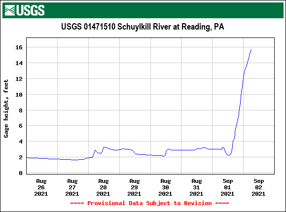
Flooding at rivers and creeks around the area are going through extreme flooding.

-
No further rain overnight so still at 5.41" for the event. Currently 62 with dp 57.
-
Was still getting on and off rain and finished up with 5.41" for the day (since it is now past midnight). Any additional will make it a 2-day event. There's still a little back edge left so maybe a couple hundredths more might be added on if that. Currently overcast and 63 with dp 63.
-
Here is the latest - 3 hour delayed (for state workers) so appears the state will be open but the rivers haven't all crested yet so stay tuned because that might change.
-
The 100 year ones are annual though, so there's that.