WxSynopsisDavid
-
Posts
563 -
Joined
-
Last visited
Content Type
Profiles
Blogs
Forums
American Weather
Media Demo
Store
Gallery
Everything posted by WxSynopsisDavid
-
Eyewall is closed, no dry air entrainment whatsoever into the core. All is good, what you are seeing is land interaction, friction induced.

-
Can’t recall a cane that was tilted like that, a TS, undergo the struggles it endured earlier today to bomb out like this and be knocking on Cat 4 intensity. I’m sure some of you can remember an analog, and I’ll be interested to know and study it if provided.
-
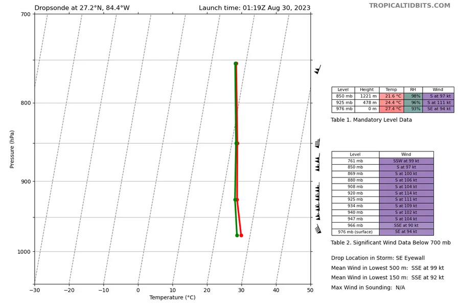
I’ll take that bet and say another 20mb drop. If I’m wrong a round of shots on me? But this has to be one of the more impressive inner structures and eyewalls we have seen recently.
-
Seems to be a climo with these gulf canes approaching Florida. Ian at one point had this feature if I recall correctly.
-
Really interesting but NHC states intensification will continue on landfall bringing intensity to Cat 4 as it landfalls. Seems to be specifically calling for a frictional-induced RI at landfall.
-
They now have landfall intensity at Category 4
-
Not necessarily, as mentioned this happened earlier tonight on a similar scale and Idalia managed to continue intensification. Unless it’s a true ERC then intensification should continue. I mean, while this was happening, Recon Hunters got 957mb so it didn’t hinder pressure falls at all.
-
Yeah I was thinking about Dennis, great analog to reference. Inner structure almost a carbon copy.
-
-
Not actually, as been mentioned earlier there’s been mesovortices rotating around the eye at times. When that happens the eye will appear ragged/rugged but it’s actually not a deterioration.
-
There’s a few mesovortices rotating around the eye, not something we typically see with Category 3 hurricanes.
-
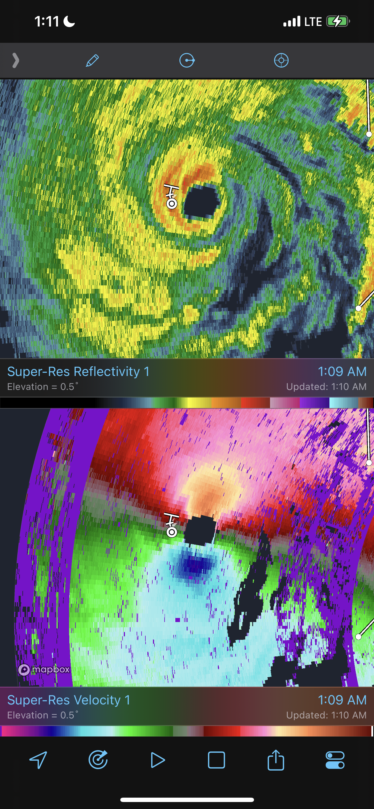
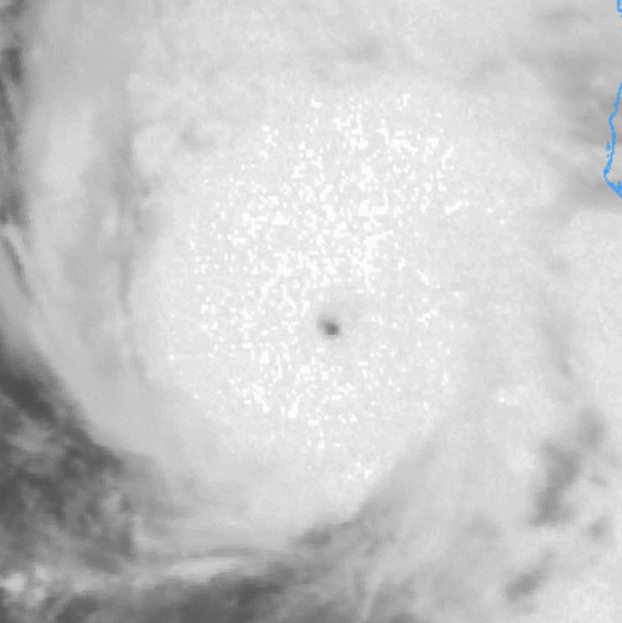
Can see it on satellite imagery too. Pinhole eye, so I anticipate based on previous major canes that feature pinhole eyes…a period of rapid and steep pressure falls are near.

-
He’s a tad late to the party, Idalia is currently strengthening into a Category 3 as I type this. Considering it’s got 12hrs left, I assume “likely” is a typo. He meant to say Idalia will intensify into a Category 3.
-
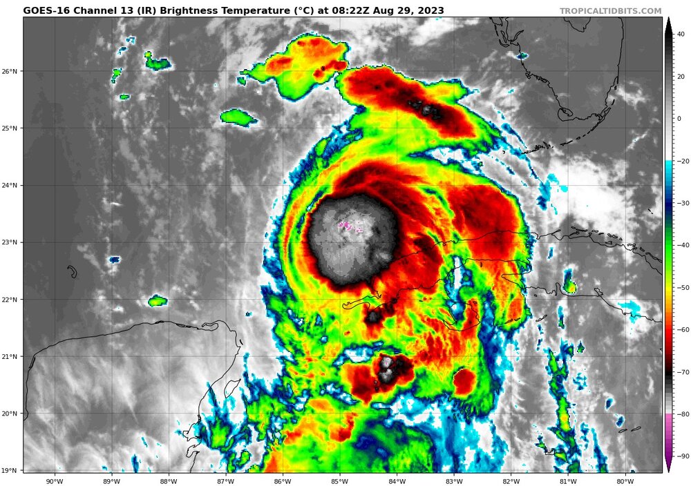
Inner core structure is extremely healthy. Column is vertically stacked as evident with the noticeable outflow expanding across all 4 quads. Ventilation looks uninhibited, Idalia is about to tank rapidly. Could see a very steep, very sudden drop in pressure soon.
-
I been told they are using drones to also recon Idalia. That data set is not available to the public. It’s possible they got the 100mph reading using other methods instead of Recon Hunters.
-
Good lord that’s a tight, compact eye. If that thing stays looking like a pinhole, I would hate to be the recon hunters having to fly into that sucker later today.
-
Faster forward speed also limits the likelihood of eyewall replacement cycles being induced. This means the chances are increasing that Idalia rolls in at peak intensity on landfall.
-
Idalia is…FINALLY…a Category 1 hurricane
-
Finally appears that the centers are aligned and stacked. Vertical column significantly healthier and less tilted. Idalia now into the southern Gulf…and rapidly getting symmetrical. Idalia has that look now, as soon as the eye clears this thing bombs. Hopefully it’s when we have recon inside the storm.
-
It’s plausible but this hinges on Idalia taking full advantage of the pristine environment ahead. This would indicate lack of shear upon landfall and minimal hindrance from the trough. Lastly, it would suggest Idalia does not have any eyewall replacement cycles before landfall which is plausible if forward speed increases.
-
But how much storm surge in my back yard will there be?
-
Indeed, finally seeing a consistent burst of deep convection and it appears that deep convection is wrapping the core now. Marketable improvements upshear, I suspect what is happening now is that column is trying to get vertical which should happen very soon, once it clears Cuba. IMO...the environment ahead is the best environment an Atlantic tropical system has had since Michael. All systems are go, once it clears Cuba, for RI. Some indication I seen in previous runs of the COAMPS that suggests a potential period of explosive intensification once it gets over the loop current tomorrow afternoon.
-
Once it clears Cuba that should happen, but it's definitely lopsided and that column is not quite vertical yet.
-
Correction....Category 6.5 to the 3rd power
-
Your comment earlier about Idalia looking like trash garbage inspired greatness.