WxSynopsisDavid
-
Posts
563 -
Joined
-
Last visited
Content Type
Profiles
Blogs
Forums
American Weather
Media Demo
Store
Gallery
Everything posted by WxSynopsisDavid
-
-
Done, just created it.
-
Banter for Idalia
-
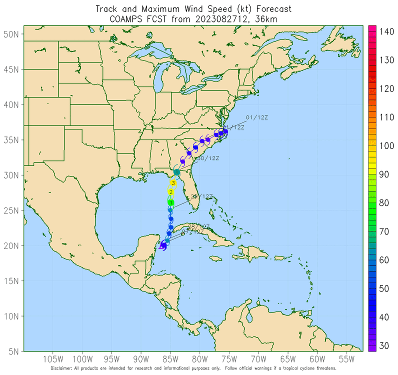
As I mentioned earlier, until we get a solid core and eye with Idalia models will continue to fluctuate with track and intensity.
-
Honestly, until Idalia develops a solid core (which will take several more hours), model track and intensity will continue to fluctuate.
-
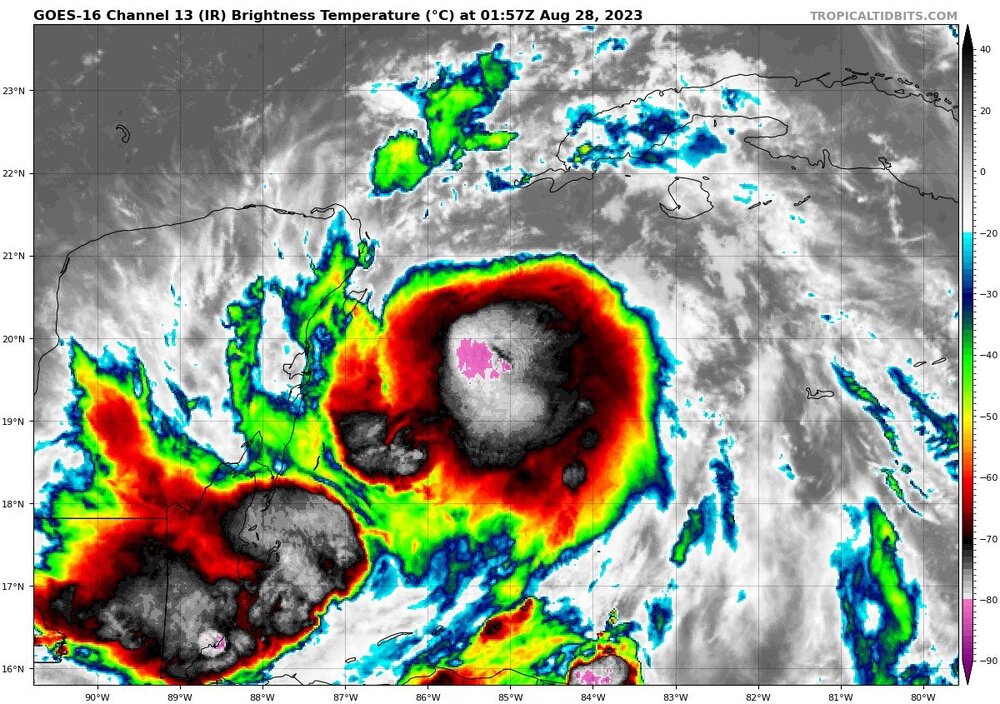
Negative. The cloud tops are casting a shadow that is given the appearance of an eye. No eye is developing yet, according to recon.
-
Shear has actually rapidly decreased the last 3 hours. Shear values north of Idalia went from 40kts to 25kts now. Dry air has abated the core and there’s little dry air to the north. This is a similar environment that Michael had in all honesty. One could argue a better environment ahead than what Michael had.
-
No one has forgotten but there are still uncertainties on track and intensity. Unfortunately we won’t really know for sure what those impacts will be until Tuesday.
-
I’ll take that bet and say 12hrs tops. So far what Idalia was able to pull off with 30kts of shear was impressive. Also….Idalia is now beginning to interact with a noticeable warm eddy so I think because of this the process happens much sooner.
-
Once that vertical column stacks, it’s game on. We are close now to that happening.
-
Night man, thanks for the analysis and breakdown of recon data.
-
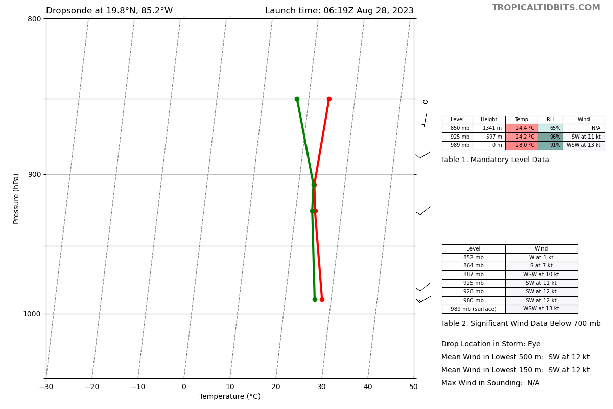
989mb
-
My suspicion is that there is some sort of internal process happening. Next 3-6hrs will be interesting.
-
Someone with more experience can correct me if my assumption is wrong, but if the vertical column stacks within the next 6-8hrs i believe the worse case scenario will unfold. Really hinges on how Idalia organizes/develops the core and if it continues to abate the shear and dry air
-
Not good, this falls in line with the hurricane models that have been on the higher-end of the intensity forecast.
-
Right at the end of the loop, you can see that the lightning activity starts to ramp up and circles around the core, noticeable ring like feature. I have only seen that with systems that are beginning an RI process or systems that have an RI underway.
-
-
I agree, this is likely the beginning of an established inner core being developed. Very impressive to see this right now.
-
Really don't want this thing to take it's time moving ashore in those warm SST's. Not a great trend to have in this juncture. However...only real silver lining with a slower speed is it will increase the likelihood of an internal process such as an Eyewall Replacement Cycle being induced. Current forecast, showing Idalia moving ashore at a faster speed, does not support internal processes happening.
-
Disagree, Idalia does not even have an established CDO yet so what's happening tonight is not in relation to CCC. Idalia's issue is shear ATM. Once convection can stay consistent and shear/minimal dry air can abate, this thing takes off. Pretty much...the vertical column is not stacked yet and that is Idalia's hinderance in the short term.
-
-
That link is for TS Franklin, not TS Idalia.
-
When the circulation becomes vertically stacked you have a Category 1. So of course, circulation is not stacked as we don't have a category 1 yet.
-
At the very least, I am more interested on the data they collect out ahead of the system across the Gulf. Curious to know if the models are right concerning the non-existence of dry air and the observations yielding decreasing shear.
-
Agreed, and it is not good that as forecasters we have no limiting factors in play here to discuss. It's come down to how long it lingers near the Yucatan....really feels like dejavu from some of the previous big gulf storms we have forecasted.