WxSynopsisDavid
-
Posts
563 -
Joined
-
Last visited
Content Type
Profiles
Blogs
Forums
American Weather
Media Demo
Store
Gallery
Everything posted by WxSynopsisDavid
-
The downside to using pressure is Sandy and Fiona type events. They had pressure of Cat 4’s but struck at much lower intensity concerning winds. I do like where this conservation is going because it’s obvious the Safir Simpson scale is outdated. It doesn’t do a good job with these Sandy, Fiona, Ike, Katrina, Ian type storms.
-
Michael didn’t achieve Cat 5 until the review process and the TCR was composed. Andrew didn’t achieve Cat 5 until the reanalysis in 2004. When these storms landfall there’s a whole set of data they have that we don’t have access to that they flag for review purposes. We see only what they want us to see if the recon data. So in saying that, we will wait and see what their review shows of Ian. Keep in mind damage might not look that bad and understand a lot of that area was rebuilt after Charley. Michael rolled through an area that had poor building codes.
-
That’s very impressive, Irma for comparison was 125 TJ
-
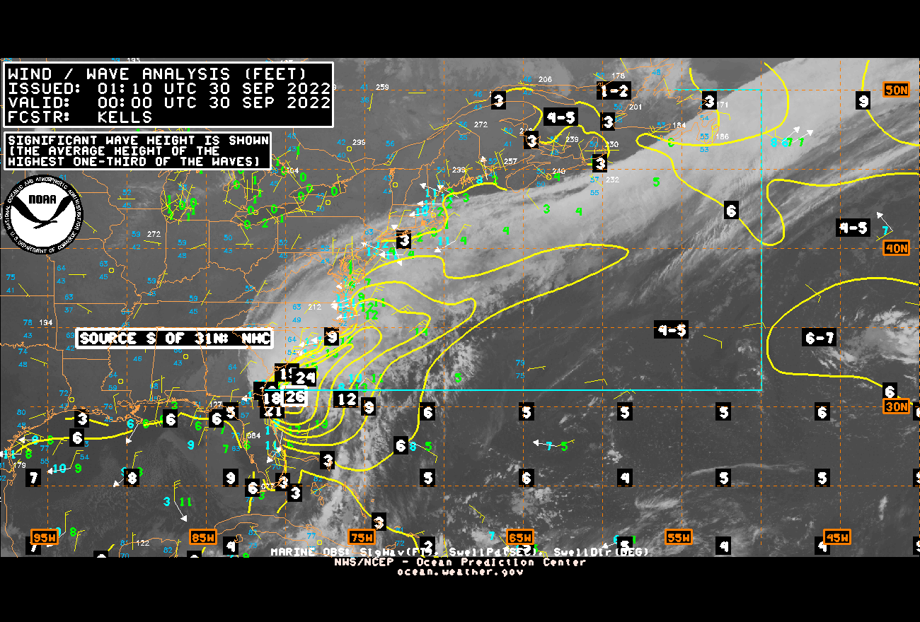
Those wave heights are fairly significant and increasing gradually

-
Well…..there’s a likely 20 that can be added to the death toll

-
Yeah…..we aren’t seeing the worst of it. This is going to be like some of the high-end canes in the past. Whereas we don’t see the worst until like the Day 3 range when they start to get to those areas.
-
Here we go with this BS we endured after Katrina. The ignorance of some people…idk why I even try. What’s said is I even scrolled through Twitter and saw post from local Mets down there saying “we had little time to prepare” or “this was only suppose to be a weak hurricane”
-
Hurricane Michael had ridiculous storm surge around Mexico Beach, so for me, that’s the recent storm that comes to mind.
-
Unfortunately we never know the true extent of the wind damage until after the fact
-
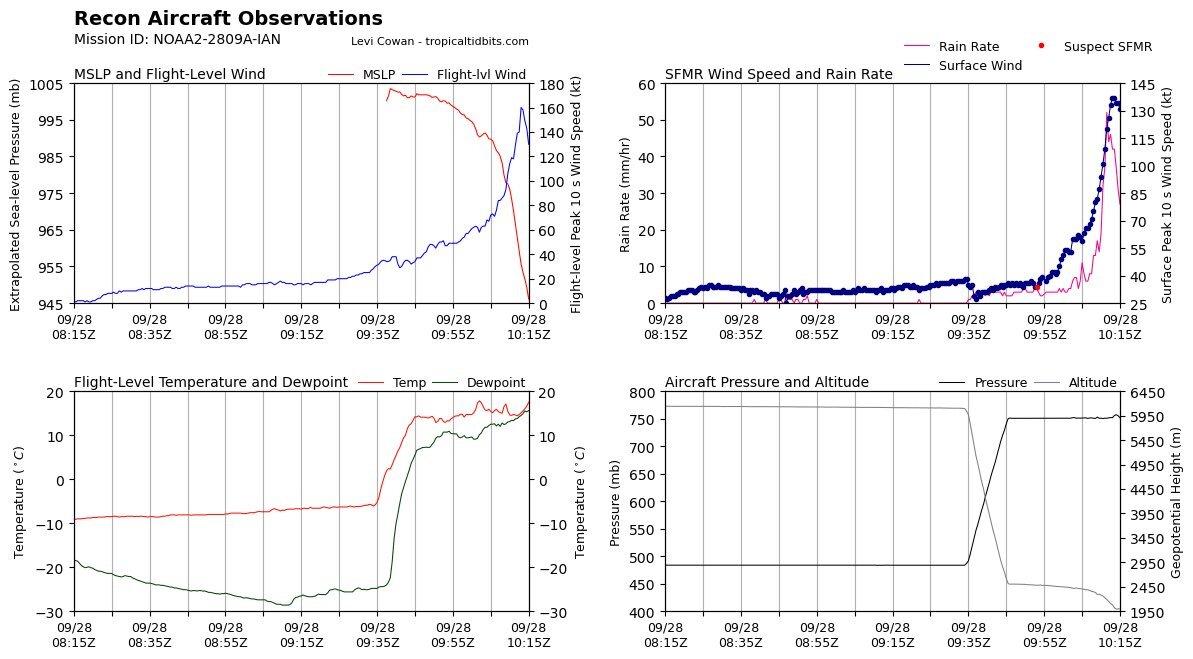
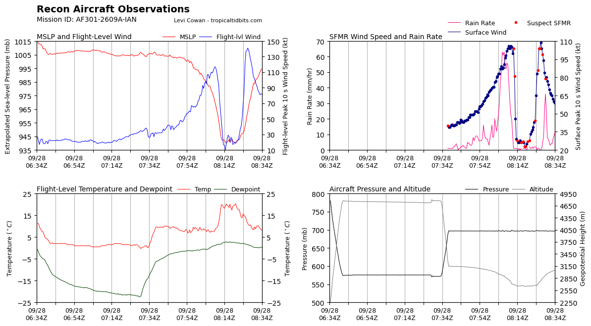
It contracted earlier between 2am and 4am before this RI process
-
Really doesn’t matter now, damage has been done. Whether it stays 155mph or weakens to 130mph, or perhaps 110mph, the surge event is going to be catastrophic. Too late in my opinion
-
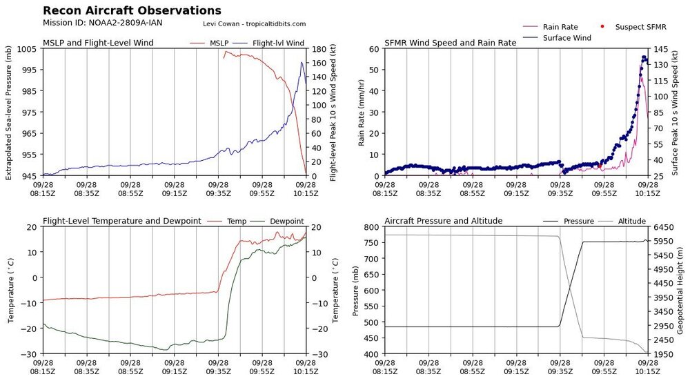
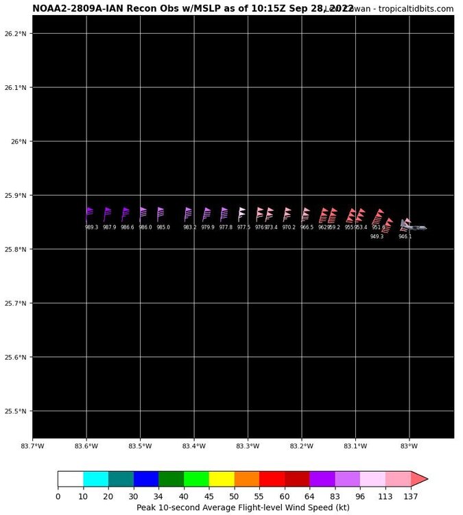
Impressive but not the surface level
-
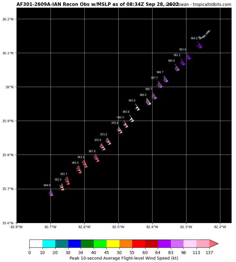
Well…..blending the Flight Level and SFMR data this yields surface winds of 155mph
-
I pulled it and thought it was current but according to the time that would of been like 4:57am….unless I’m going stir crazy. I deleted the post
-
It’s also now over a branch of the loop current which is also aiding the RI we are seeing….along with friction and angle of approach.
-
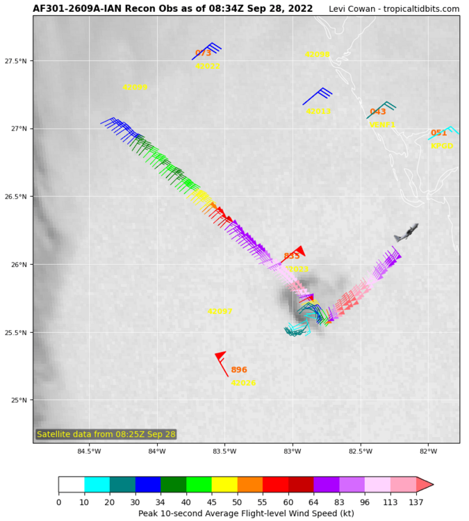
Ian is now a Category 4, dataset supports it. Also, Ian is an intensifying Category 4


-
Curious as to what they find
-
Eye has contracted and is tightening up. Deep convection firing in the N/NE eyewall right now. At 2:00am the eye was over 30mi wide. Now at 3:25am the eye is about 22-23mi wide.
-
Looks like not only is the eye clearing but there are what appears to be mesovortices rotating around inside the center which is giving that ragged appearance on IR. It almost appears like the eye might be a pinwheel eye
-
Its wobbling back and forth, which TC's typically do as their tracks are not smooth
-
The angle of approach and potential friction Ian is feeling would likely enhance any RI process that commences. Correct me if im wrong, given what I just said and the environment Ian is in, this is not the time to have a major hurricane undergo RI. There's little real estate between Ian and Florida now. Also, the classic limiting factors like dry air and shear have done nothing to limit/hinder Ian. With the deep convection primarily located upshear like what was noted by someone else in here earlier, Ian will continue to be resilient to dry air/shear.
-
NOAA NHC Recon Hunters will be dropping a UAS/drone inside Ian tomorrow that will last 3.5hrs. Curious to see what it finds and the data that is collected
-
I really want to comment to this on Twitter but I feel it’s a waste of time. If he’s that ignorant to be using the HRRR right now it will be like talking to a brick wall to make a point. I really wish, as a local met down there, he will focus more on the environment and mesoscale instead of the HRRR’s ever so changing hourly landfall locations.
-
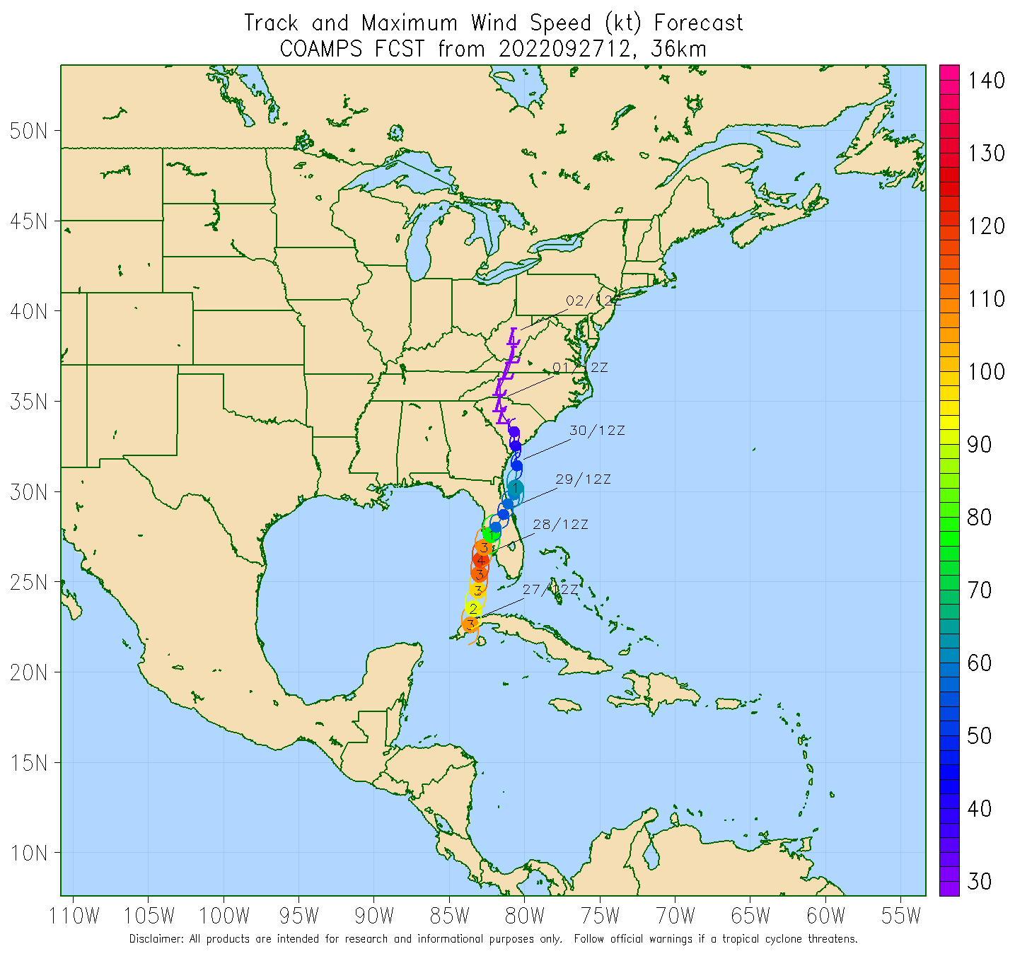
COAMPS 12z, waiting to see if we ever get an 18z run or if they are gonna skip past the 18z


-
Yes they are hurricane models but they tend to have issues concerning inland tracks at this range. For the time being I would be more focused and concerned with the environment they depict later tonight ahead of Ian