George001
-
Posts
6,887 -
Joined
-
Last visited
Content Type
Profiles
Blogs
Forums
American Weather
Media Demo
Store
Gallery
Everything posted by George001
-
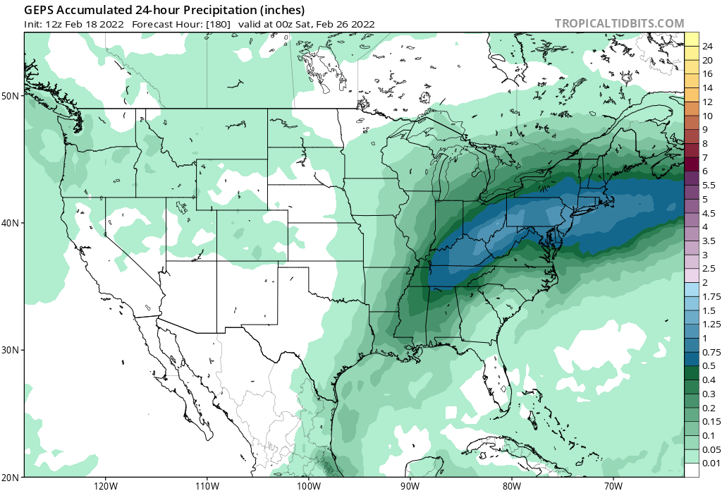
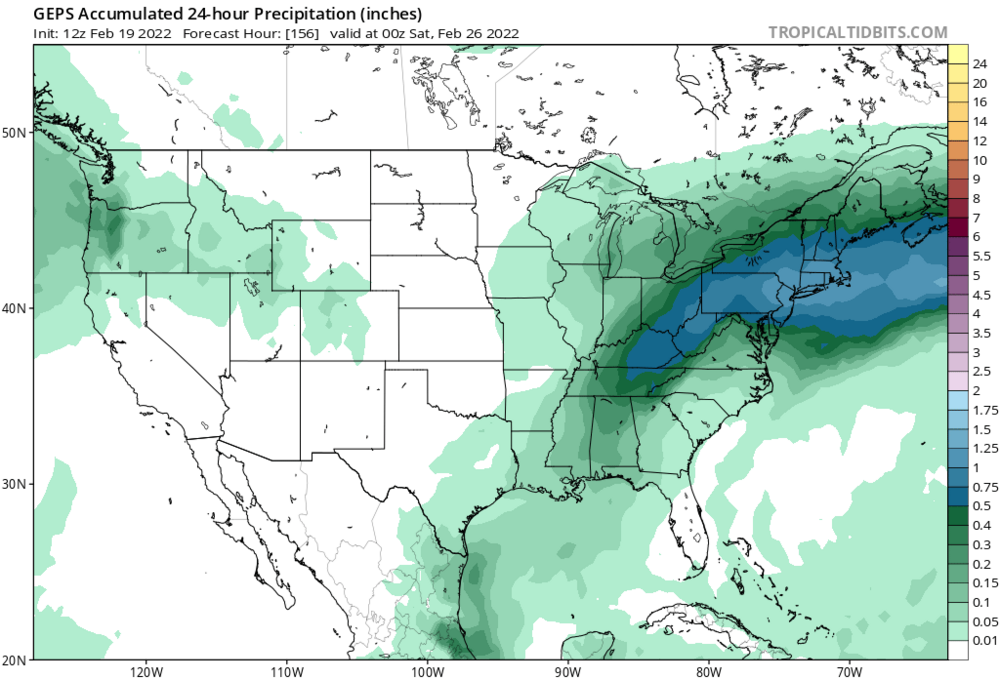
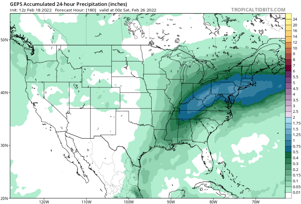
The geps doubled down, this system is loaded with moisture. That’s a big area of 1+ inches qpf on a mean. This far out that’s a huge signal. Will the storm track likely be north of the gfs? Yeah, but that’s a good thing. Gfs is south of ideal. I’d like to see the Euro and eps bump south some, but the geps look really good. Euro looks good track wise but it is kind of weak with limited moisture. Imo we will see op runs start beefing up the QPF as we get closer to the storm, with this evolving into a something more significant than a typical swfe. The question is how much of that QPF is snow.
-
Canadian has some front end before a changeover
-
What changes would we need to see on the models to see a shift towards a Feb 2 2015 type solution rather than a boring ol 4-7 snow to mix to drizzle+dryslot SWFE? The OP runs don’t look great but it seems like the ensembles are more aggressive with the snow.
-
yeah pattern doesn’t support the gfs. Swfe on roids Miller B hybrid.
-
I like how far north the vortex is, that should help us avoid suppression like March 2014.
-
Yeah that looks like it would be. Late Jan 2015 I believe was one of those, hopefully we can get the pieces to align for something similar. Pattern looks great.
-
I’m going with a blend of the big 3, I do think gfs is too far south. However, I would say the ceiling is 18 inches not 8-12 due to all the moisture involved. There is also a good amount of confluence in the upper levels so that should help with a more favorable mid level track.
-
Eh idk we have a very strong high to the north with secondary redevelopment. I don’t buy this being a run of the mill SWFE, it’s trending into a juiced up SWFE/ Miller B hybrid.
-
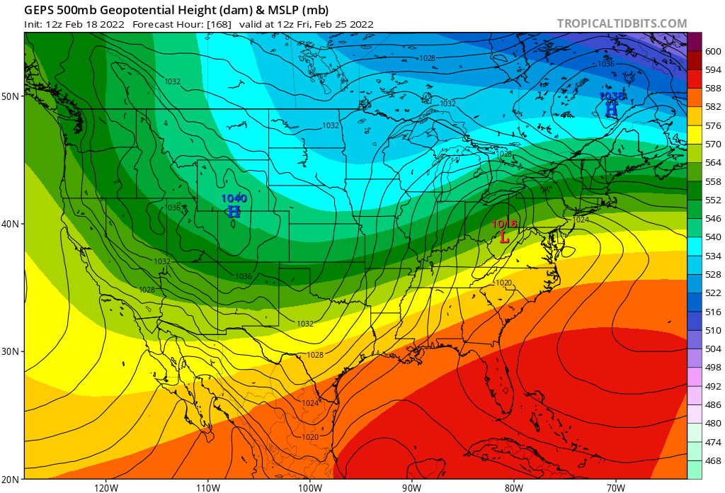
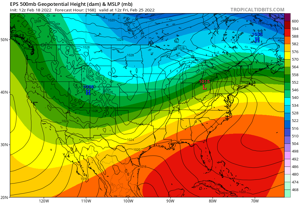
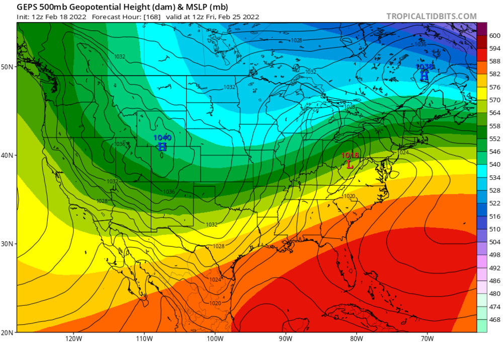
1038 mb high to the north in a decent location on the Canadian. I’m leaning cold and snowy with this one, I looked at the ensembles a bit more and really like what I see. This setup has a lot going for it, even the Canadian although it’s warmer it has a decent low track and the secondary redevelopment. The European guidance has been the warmest with this, and it trended in the right direction this afternoon. I would like to see another bump colder on that.
-
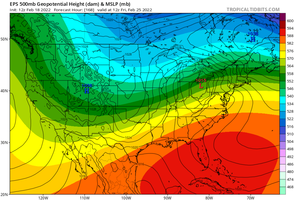
For the Friday system the question is, is this a run off the mill SWFE, front end snow to mix then drizzle and dry slot, or is it something more? I was originally thinking it was just a run of the mill SWFE, but the models have trended towards more secondary redevelopment (Miller B) over the past couple of days. This is seen on the 12Z EPS. The GEPS is even more aggressive with the secondary redevelopment and has an absurd amount of moisture involved, shown in the pics below. that’s a widespread .75+ inches of QPF with over 1 inch in the mid Atlantic, and that’s a mean 7 days out. There is also a strong high to the north on all guidance, 1038 mb in an ideal location. That’s arctic airmass to the north combined with the clash of well above normal temps to the south, has me convinced that this system will have significantly more moisture than a run of the mill 4-8 inches of snow SWFE. This type of setup we will see above normal temps south of the boundary and below normal north of it, but the temp contrast with this system is much more pronounced than normal. We have a near 1040 mb high clashing with a mild southern airmass bringing near record high temps to the area on Wednesday when the first storm passes to our north. My area is forecast to reach 60 degrees on Wednesday, this is the average temperature for mid April, not late Feb. We are going to have arctic cold ramming into that unseasonably warm airmass to the south. Due to these factors, in my opinion this has room to juice up even more.
-
I’d say B right now. December was garbage, January was epic with a monster blizzard, and Feb we had a decent snowstorm mid month with another threat Friday. Feb is still up in the air depending on how that works out. Whether or not this winter stays at B, goes down to a B- or goes up to an A rides on late Feb and the rest of March. If we get another blizzard this winter moves up to an A. Above average snow+ 1 monster blizzard automatically takes us above a C, 2 and well above average snow (60+ inches) and this winter is an A. A+ is reserved for the record breaking winters. Well below average temps, 3+ blizzards, nearly double our average snow or more, and great snowpack retention. These are the 2014-2015, and 2010-2011 type winters.
-
I like what I saw on the models today for the Friday threat, Euro has shown signs of secondary redevelopment it previously did not have, leading to a colder solution. I know SWFEs are typically moderate events like 4-8, closer to 8 north and 4 south where there is more mixing, but that secondary redevelopment is making me question that. It looks like it could be turning into an SWFE Miller B hybrid, if that happens in my opinion the coastal low redevelopment would not only lock in the cold air but it would enhance precip rates. This would lead to increased snowfall totals in eastern mass, and put us south of the pike in the game for double digits. Correct me if I’m wrong, but if looking for higher end totals compared to a typical SWFE we would be looking for earlier redevelopment and more rapid strengthening of the secondary (Miller B) right?
-
Welp, the snowpack was fun while it lasted. 60 to snowstorm and then a few days later 60 again, yep that’s New England weather for ya.
-
Central and western Mass I think it will, and if the second half pans out even Eastern Mass. I’m all in on a big March.
-
I’m convinced it will be, honestly I don’t think it’s out of the question March is better than January.
-
My original call was for 70-85 inches of snow in the Boston area for my first official winter forecast. I am sticking to my guns with this, although I do think it will be a “right for the wrong reasons” type deal as I expected the polar vortex to be weak.
-
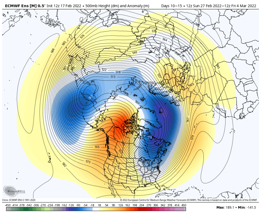
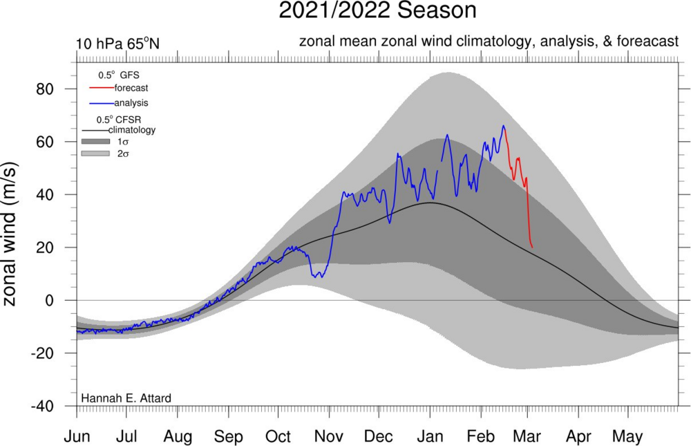
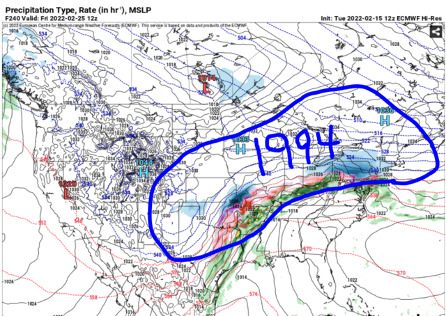
This thread will encompass the late winter to early spring window. The models have shifted away from a mild pattern for late Feb into early March to a much colder and potentially stormy pattern. My early thoughts for the late Feb period is that it does not favor an all snow event for SNE, due to the SE ridge in place and warming mid levels. However, there is a strong high to the north, so I do think there could be a significant (6+) front end before a changeover to sleet or ice. I’d favor north of Boston for the biggest snows, with Boston south getting a decent front end before a changeover. I do not think this will be a huge storm, 6-12 inches. Closer to 6 for the areas that mix and 12 for the areas that stay all snow. Although for the late Feb pattern there aren’t any signs of a huge storm, there is the possibly that if things break right we could get 2 or even 3 waves due to the energy out west ejecting in pieces, not all at once (if it does eject all at once, it would likely cut inland). We do not want a phase here). What once looked like a torch turned into a very interesting period with snow sleet and ice all on the table. Now the period that really interests me is early to mid March. I have read concerns about suppression and have seen comparisons to March 2014, but in my opinion this is unlikely. Why? In 2014, the vortex was over Maine. On the EPS, the vortex is east-central Canada, which is several hundred miles north of 2014. This argues that storms would have more room to come north than 2014. We also have an extremely amplified western ridge axis. The ridge axis is centered over Washington state and is poking up all the way to Alaska. Ideal for east coast cyclogenesis is over Montana, so if anything it’s a little west of ideal. This looks very similar to the Jan pattern but if anything, the western ridge is even more amplified. This suggests that any northern energy has room to dig very far south, enough to tap into gulf moisture and phase with any southern energy available. The biggest and most important difference is it is early March, not early January climo. This is double edged, as the milder late winter waters clashing with the arctic airmass in place would encourage more explosive cyclogenesis, leading to a stronger low and farther NW low. However, if the track is too far NW it wouldn’t take as much to bring in warm air and flood the coast with rain (like the early Feb event last year, where Boston didn’t get much and interior areas got slammed). Rain snow lines are absolutely a concern, so I would like to see a Miller B or hybrid system more so than a Miller A for my area, but either way the potential for a big storm is there. In my opinion, this is the most explosive pattern I have seen since March 2018, and honestly has the potential to be even more explosive than that. We have an extremely amplified and western ridge displaced very far west combined with a piece of the polar vortex over central canada. We also have a weak east based La Niña currently in place. East based La Niña climo tends to be favorable in March, more so than western or central based events. my bold call: for many areas, there will be a storm in early-mid March that ends up being STRONGER than the January blizzard, and delivers even more snow. The question is, what happens in mid to late March? We are seeing signs that the polar vortex could finally start to rapidly weaken, which could lead to this favorable period being extended all the way to early April. If that happens, I believe we will get 2-3 big ones (12+) with possible a couple moderate (6+) ones mixed in as well. That is the upside with this pattern. Will it happen? It may not, but even if it doesn’t I am still convinced that the early-mid March period will deliver, and could even deliver 2 big ones, yes even with a positive NAO. Then we have the mid March to early April period that could be interesting as well. The thing about the near record strong polar vortex we have right now is that when it does get disrupted and is displaced or even split (unlikely, I’m leaning displacement right now), all that cold air bottled up over the North Pole is going to come crashing south. This is an anomalous event, so we could see some crazy ass shit. A lot of you will probably think I’m going off the deep end here, but I’m just gonna say it. I think there will be a window in late March early April, with a much higher probability than normal for an April snowstorm this year. If I’m wrong I’m wrong, but when we combine the already colder than average Canadian airmass in place with a record strong vortex being possibly displaced or split, if it is displaced to this side of the globe, April 1997 becomes an analog (correct me if I am wrong, but I read that this was also a strong PV winter). This does not mean something as extreme, but a muted version of that? Hell yeah! Will the PV be displaced to this side of the globe? It may not, but I believe it will due to the polar vortex having a tendency to elongate and stretch toward this side of the globe this year, sunlike previous strong PV winters like 2020.
-
Thanks, I appreciate the support. I have definitely had my share of busts, but feel like I am learning a lot from the mets and experienced posters here. I definitely still have a long way to go, and will continue to learn and improve. I have made some significant adjustments to how I analyze the models this winter, and will keep making adjustments as I learn. I have a post coming up about the late Feb-early March period. The mid March to early April period, I’ve been keeping a close eye on the models over the past few days and like what I see. It’s still early for that though, and would like to see the signal for a polar vortex weakening to move up in time and strengthen on the guidance over the next couple of weeks. I’m thinking even if the polar vortex stuff doesn’t pan out, we are going to get something nice in the first half. If it does pan out, I’m thinking we could have things really get wild with multiple big events such as March 2018, Jan 2011, or even a redux of this January. We need a lot to go right for something like that to happen, so I’m going to pump the breaks a bit on forecasting something like that for now. Either way, I’m just happy that we likely aren’t getting shut out like it appeared week ago.
-
Could be interesting for the 2nd half of March and possibly even early April. If the pattern is good enough, it can and will snow even late March and early April. Winter is going out with a bang, not like last years sorry excuse for a winter.
-
Not saying it’s going to be anything huge, but if it gets cold the snow chances will follow. Some of the models are showing below average temps.
-
Even late Feb which looked like it was going to torch is trending cold and snowy.
-
Yep (from another forum)
-
Yeah the eps has shifted colder in the long range. Winter isn’t going anywhere.
-
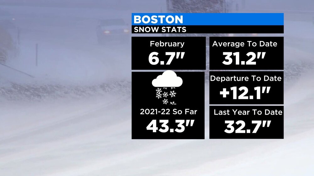
I’m feeling much more optimistic about winter than I was a few days ago with the big overperformer yesterday and positive trends on the models for the long range. Boston already has had more snow than all of last year (I believe Boston finished with just under 40 last year) and we have a month and a half left of winter.