George001
-
Posts
6,887 -
Joined
-
Last visited
Content Type
Profiles
Blogs
Forums
American Weather
Media Demo
Store
Gallery
Everything posted by George001
-

March 2022 Obs/Disc: In Like a Lamb, Out Like a Butterfly
George001 replied to 40/70 Benchmark's topic in New England
I know I’m grasping at straws a bit here, but it’s a strong storm and not that far NW. What are a couple of wild card factors that could change things so us in eastern mass are in the game for big snows as well? Something like the energy closing off maybe? -
March 2022 Obs/Disc: In Like a Lamb, Out Like a Butterfly
George001 replied to 40/70 Benchmark's topic in New England
Yeah that is ideal for east coast cyclogenesis, I’m rooting for the ridge to trend more amplified to give the storm more room to dig and get farther se areas in the game. -
March 2022 Obs/Disc: In Like a Lamb, Out Like a Butterfly
George001 replied to 40/70 Benchmark's topic in New England
Quite a few slightly offshore lows -
March 2022 Obs/Disc: In Like a Lamb, Out Like a Butterfly
George001 replied to 40/70 Benchmark's topic in New England
this is worth watching even if the surface shows rain.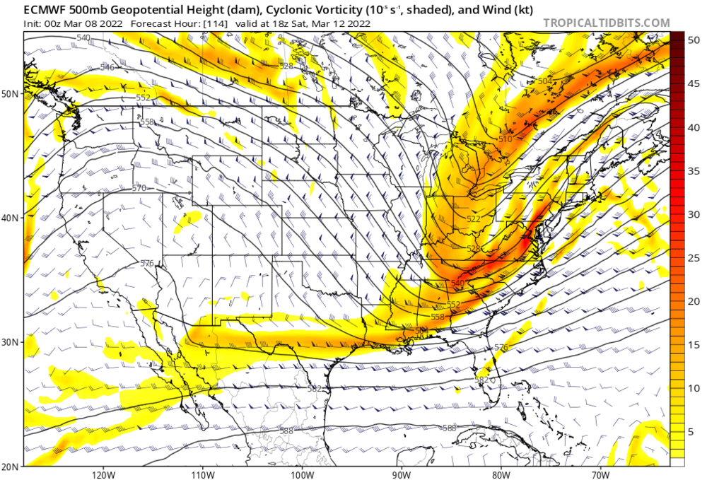
-
March 2022 Obs/Disc: In Like a Lamb, Out Like a Butterfly
George001 replied to 40/70 Benchmark's topic in New England
984 mb is fairly strong, would like to see the deepening happen a little sooner though. Also need the overall evolution to slow down a bit so the cold air has more time to establish itself. -
March 2022 Obs/Disc: In Like a Lamb, Out Like a Butterfly
George001 replied to 40/70 Benchmark's topic in New England
Huh? The low only needs to shift 50 miles east, still 5 days out. -
March 2022 Obs/Disc: In Like a Lamb, Out Like a Butterfly
George001 replied to 40/70 Benchmark's topic in New England
That is very close, the airmass isn’t great but the low is strong enough to create its own cold air. Need to get the low to track a little farther east and game on for a rain to heavy snow scenario. -
March 2022 Obs/Disc: In Like a Lamb, Out Like a Butterfly
George001 replied to 40/70 Benchmark's topic in New England
Too early to write it off, it looks bad but there’s still a couple weeks left for us to possibly get lucky and get a big storm and snow in a bad pattern. There’s no way we get shut out for the entire month…. -
March 2022 Obs/Disc: In Like a Lamb, Out Like a Butterfly
George001 replied to 40/70 Benchmark's topic in New England
Ensembles look good for mid month, I’m not giving up until early-mid April. -
March 2022 Obs/Disc: In Like a Lamb, Out Like a Butterfly
George001 replied to 40/70 Benchmark's topic in New England
Also despite the surface trending worse from 0z, the upper levels trended better, there was hardly any blocking at 0z. We need that to continue to get the storm to redevelop farther south. -
March 2022 Obs/Disc: In Like a Lamb, Out Like a Butterfly
George001 replied to 40/70 Benchmark's topic in New England
This far out that’s doable, also you if the low deepens as much as the Euro says it will we don’t need a perfect track. The storm will create its own cold air, and the rain snow line would crash south. It can snow east of the low. -
March 2022 Obs/Disc: In Like a Lamb, Out Like a Butterfly
George001 replied to 40/70 Benchmark's topic in New England
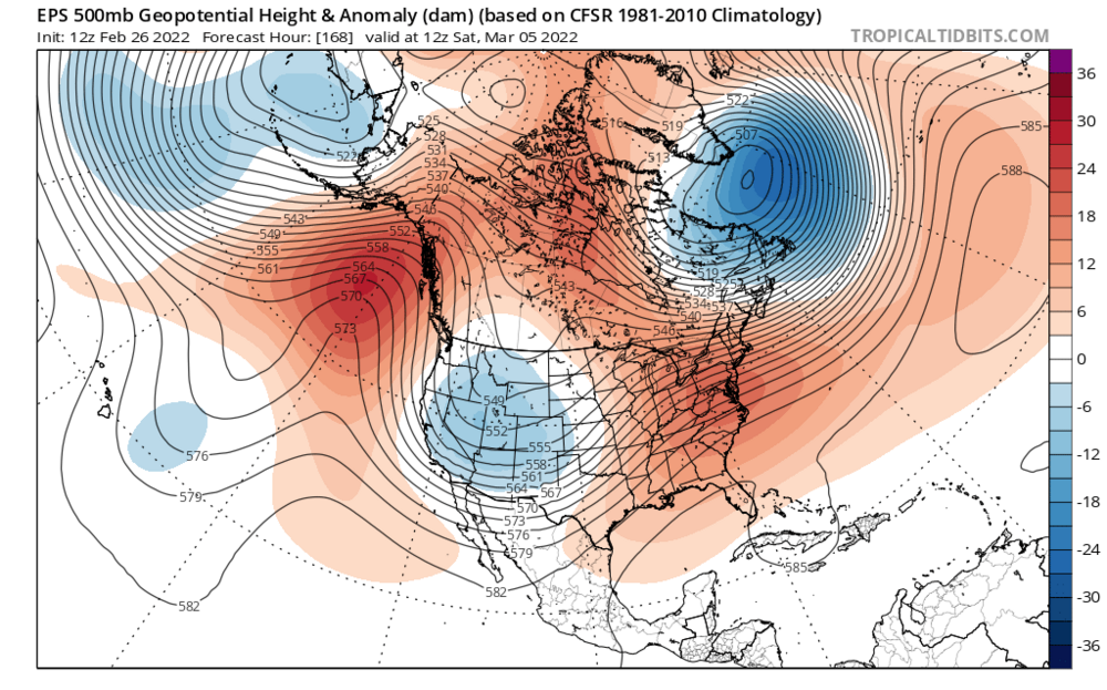
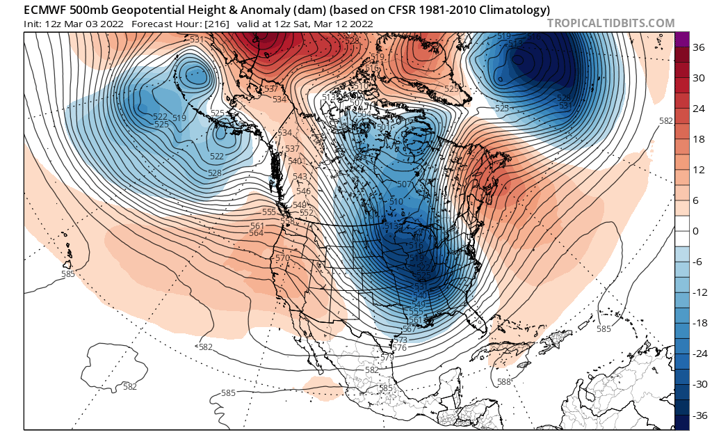
Greenland blocking showing up on the Euro, this threat looks interesting.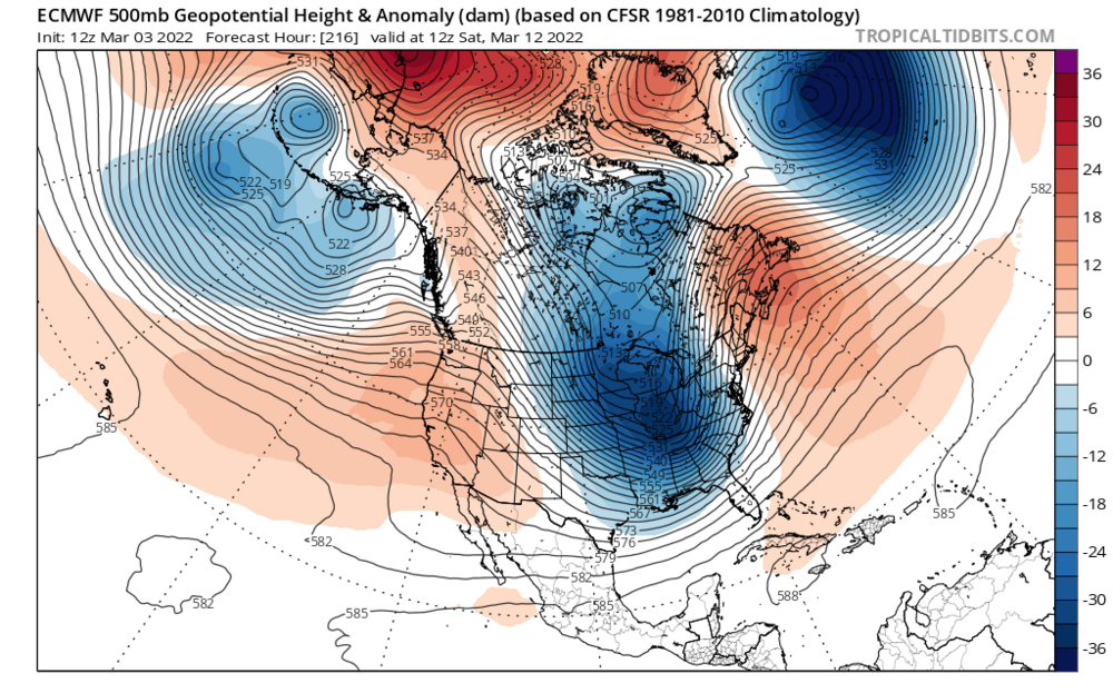
-
March 2022 Obs/Disc: In Like a Lamb, Out Like a Butterfly
George001 replied to 40/70 Benchmark's topic in New England
I need to see a few more favorable changes in the pattern before I start talking blizzards, right now the western ridge axis is west of ideal, so an inland runner is possible. However there are signs of weak North Atlantic blocking starting to form, which could turn it into a Miller B. If we see the blocking strengthen on the guidance, then I’m all in. -
March 2022 Obs/Disc: In Like a Lamb, Out Like a Butterfly
George001 replied to 40/70 Benchmark's topic in New England
Eps looks decent, geps is also trying for a Miller B. That’s what the models look to be hinting at right now, a low initially cuts to our west, but then redevelops and bombs out just a little too late. Get that redevelopment to happen a little earlier and all of a sudden we have a big nor’easter. -
March 2022 Obs/Disc: In Like a Lamb, Out Like a Butterfly
George001 replied to 40/70 Benchmark's topic in New England
Is that North Atlantic blocking over Greenland? Wow -
March 2022 Obs/Disc: In Like a Lamb, Out Like a Butterfly
George001 replied to 40/70 Benchmark's topic in New England
that’s a very strong signal this far out
-
I’m rooting for that to be right. I’d like to see a late March early April nor’easter/blizzard, and it looks like we could have a shot at it this year.
-
March 2022 Obs/Disc: In Like a Lamb, Out Like a Butterfly
George001 replied to 40/70 Benchmark's topic in New England
I agree, if the NAO is raging positive, it’s not ideal but it can work (like 2014-2015). If there is a trough out west it is a lot harder to get big storms. -
March 2022 Obs/Disc: In Like a Lamb, Out Like a Butterfly
George001 replied to 40/70 Benchmark's topic in New England
The polar vortex reconsolidates over the North Pole? Ah damn it, I thought we were having a polar vortex split just in time for a big finish. We need the pacific to improve. -
March 2022 Obs/Disc: In Like a Lamb, Out Like a Butterfly
George001 replied to 40/70 Benchmark's topic in New England
Possible PV split, there is some lag so we won’t feel the effects until mid to late March and early April. -
March 2022 Obs/Disc: In Like a Lamb, Out Like a Butterfly
George001 replied to 40/70 Benchmark's topic in New England
Yep. Still have a month left of threats, possibly a bit longer if the pattern looks great in early April. It’s going to get mild but the mild stretch looks to be short lived, with the rapid weakening of polar vortex and MJO wave dying off in the COD. Way to early to give up on winter. -
March 2022 Obs/Disc: In Like a Lamb, Out Like a Butterfly
George001 replied to 40/70 Benchmark's topic in New England
Congrats Montreal? -
March 2022 Obs/Disc: In Like a Lamb, Out Like a Butterfly
George001 replied to 40/70 Benchmark's topic in New England
Im not a fan of the look on the models for early month. I hate seeing a trough out west and a lack of blocking. We could still snow in a bad pattern because we live in New England not DC where you need a perfect pattern to snow, but probably nothing big. There are positive signs for mid month though. The polar vortex is expected to weaken a lot as well as a more favorable MJO projected mid to late March. Hopefully that leads to the pattern improving with a big storm before spring. -
March 2022 Obs/Disc: In Like a Lamb, Out Like a Butterfly
George001 replied to 40/70 Benchmark's topic in New England
Hopefully a weak one. Moderate and stronger not good for my area (though in NYC they can be better). Weak west based ninos are where we get most of our truly epic winters. 77-78, 2014-2015, 2004-2005 all had weak west based ninos. It’s been a while since we had an epic region wide winter with well above normal snow in all of New England. -
March 2022 Obs/Disc: In Like a Lamb, Out Like a Butterfly
George001 replied to 40/70 Benchmark's topic in New England
What do you think about the March 7th threat? SE ridge too strong at that point or is there room for it to turn into an swfe or Miller B? I would think we need that vortex over Greenland a bit farther south to force secondary redevelopment.