George001
-
Posts
6,976 -
Joined
-
Last visited
Content Type
Profiles
Blogs
Forums
American Weather
Media Demo
Store
Gallery
Everything posted by George001
-
 6z was OTS but close, 12z not out yet. Id like to see the Canadian and European guidance trend in the right direction even if it’s not a direct hit. Canadian and Euro were whiffs last night, but had very strong storms that brushed Eastern mass.
 -
The gfs is a useless model. The guidance is right where we want it this far out, a day ago the concern was an inland runner and thermals, now it’s ots. Windshield wipers, this happens every storm.
-
Good evening. I am hoping that kicker energy crashing into the west coast weakens or slows down, despite that being an issue on the Canadian, the low still deepens to the 960s. Some of the southern energy is buried into the southwest as well, so on this run of the Canadian it is a sloppier, more progressive solution. However, I see this as a good thing in that with a sloppy phase and issues with the kicker, it still manages to scrape eastern mass and has a very powerful ocean low. This gives credit to the idea of what the ceiling could be if everything comes together, stronger low, earlier closing off, slower storm, farther west low, more expansive precipitation shield.
-
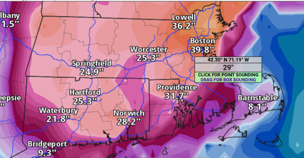
If this storm lives up to it’s potential, it will be measured in feet, not inches and it would be a widespread area too. From what I see there is both very strong northern stream energy and a very strong southern stream energy. There are like 4-5 pieces of energy, and if even 2 of them phase it’s a big storm. If everything phases, in my opinion the low will deepen even more than the models are saying right now, possibly all the way to the 940s or even 930s. I’ve never seen so many pieces of energy that strong so close together on the models, last time we got a low that deepened to the 960s (mid March 2018), the much of the region saw 18-24 inches with isolated 24-30 totals with blizzard conditions. We had a monster blizzard with a low in the 960s, if it gets down to the 940s or 930s which could happen if this maximizes it’s potential, there is a very real chance of a widespread 40-48 inches with an isolated 48-60. That is what a low that gets down to the 930s that stalls over the cape would do. Due to how many pieces of energy there are and how strong each piece is, there is a lot of room for error in my opinion. Even if only 2-3 pieces phase, if it comes up the coast that’s still a huge storm.
-
This is from Psuoffman from the Mid Atlantic board, he has lots of credible and informative posts. “Models are speeding up the NS wave. Problem with that is the timing is now off and most of the STJ wave that was responsible for the better hybrid looks gets left behind. That makes it more a miller b scenario and we all know how a Nina miller b is likely to end for us. Still time to shift back towards what we want. Several options. 1) get the 1st NS SW to slow down. 2) get it to dig further west 3) get it to speed up and clear out because there is another behind it that could link up with the stj a day or two later. Right now the timing looks off. We just need it to adjust faster or slower”. I love this development, it’s doing exactly what I was hoping for, turning into a Miller B.
-
I love seeing this on the Canadian, that’s a big improvement over the last run. I do think the idea that the rain snow line would be NW of even Worcester with a 988 min low over Nantucket to be incorrect.
-
It looks like the airmass could be an issue with the high leaving. However, I liked seeing the Canadian blow up the 2nd wave rather than the 3rd one, that’s a step in the right direction. Previous runs blew it later and had basically a replica of the inland runner we just had. However, based on the H5 it looked close to something much bigger. Although the airmass is a limiting factor, due to how much northern stream energy is diving in, the low undergoes rapid cyclogenesis and comes up the coast. The trough is too progressive on this run of the Canadian, yet it still gets a high 980s low over the cape. If the trough goes negative just a little earlier, and we get it to close off a bit earlier, the low would undergo extreme cyclogenesis and slow down, potentially deepening to the 970s or even stronger, and stalling near the cape. If the low deepens that much that quickly, although we would likely start as rain I do think the idea that we would be in the high 30s lower 40s well inland with a strong low over the cape to be bullshit. As the low deepens and the precip gets thrown into eastern mass, as precip gets heavier it would dynamically cool the column and create its own cold air. This would result in blizzard conditions with the rain snow line crashing all the way down to the canal, just NW of the low.
-
Is that…. A 964 mb low over nantucket? I don’t think I’ve ever seen a low that strong that far west before.
-
It’s Fantasy, I need to see the better models get on board before I buy in. Right now I’m thinking inland runner.
-
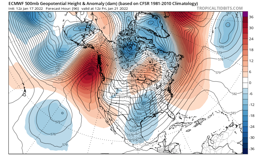
Agreed, the polar vortex is deepening, not weakening. This has been and will continue to be a strong polar vortex winter, and is actually expected to deepen to record strength in early Feb. However, the polar vortex doesn’t appear to be consolidated over the North Pole like 2011-2012. It is on our side of the globe, not a major split or displacement, but could mean there will be cold air around.
-
Disclaimer- it’s the gfs, so cannot be taken with anything more than a grain of salt. Also eastern mass appears to mix with sleet during part of the storm so it would be “only” like 30 inches in Boston instead of 40. Im very skeptical, due to the big 3 not being on board (Canadian extrapolated would be a Rainer, it blows up the following wave and the high begins to leave, like the Euro). Though if you extrapolate the navy, it has a very amplified ridge over Montana, which is the perfect spot if you want nor’easters over the benchmark. I also see some northern stream energy digging at hour 180 with less southern stream, so it looks like the extrapolated Navy would be more of a pure Miller B. Based on what I’m seeing with the lack of blocking, and farther west ridge axis and leaving high on the european and Canadian guidance, my thinking right now is suppression isn’t the concern, an inland runner is. I don’t really buy the GFS solution at all, I feel like there’s more room for us to get screwed than there is to get 30+ inches. I’d rather take my chances with a Navy like evolution, won’t see the 30+ with that but less ways to get screwed, and is more realistic.
-
I’m starting to panic because the polar vortex is deepening. If we don’t get hammered from this storm many areas could easily end up well below average for the winter. That would be a big disappointment considering how things looked a couple of weeks ago.
-
I’m actually not a fan of the look on the models. They close off at 500 mb way too far south and the high leaves by the time the storm gets up here. Looks like Miller asshole to me, we need this to become more of a Miller B.
-
I hate that it looks like there is troughing out west. Hopefully it’s wrong.
-
not gonna lie, I’m getting a little concerned that my area is going to finish the season with less than 40 inches of snow. The polar vortex is deepening, not weakening and the long range models are showing a trough out west. Things can change but not looking great right now. What are some possible wildcards that could cause things to break our way and prevent the polar vortex from deepening and consolidating over the North Pole?
-
Unfortunately it looks like the breaking down of the pattern is real. We havent gotten anything out of it yet, but still have a couple of weeks left. All it takes is one big one, my hope is we get a big one, then the thaw happens but only lasts like a week. The 26th looks like it has potential with the southern energy ejecting, if we can get it to time with northern stream energy this could be our big one. The navy in particular is more amplified than the other models for that threat, which is a massive red flag that should not be ignored.
-
Models are struggling with the pattern still, they don’t know which wave to focus on and blow up yet.
-
If the energy keeps getting held back that’s bad for the 22nd threat, but could lead to the 24th being a big one instead as the northern stream energy behind it phases in.
-
This winter has started slower than usual but we have had plenty of winters start like this and end up great.
-
Is it possible we get both if the 24th wave slows down a bit to increase the wave spacing?
-
Just last week we had a nice storm with 6-12 for most of the area, some areas even got 14-15 inches. This storm we just had was our second threat and it didn’t work out for us. It happens, not every threat can pan out, but the pattern is still very good.
-
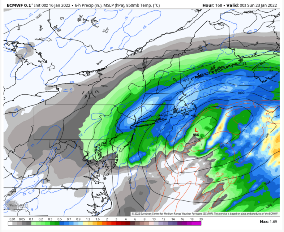
It’s only 5 days out from the storm. This is different, also it’s the best model there is. If anything these maps are underselling the potential of this storm, if it verifies like the Euro says the snow ratios will be much higher than 10 to 1. With the storm last week the models had my area getting 4-6 inches or so, but I got a foot due to the snow ratios being much higher than 10:1. The QPF the euro is projecting is expected to be around double what it was for that storm, and the low is expected to be stronger. If the Euro is correct, due to the frigid temps in the upper levels and the optimal snow growth soundings this would really end up being like 16-20 inches of snow for eastern mass.
-
look how far west that ridge is, I don’t buy the out to sea solutions at all. If anything the concern would be an inland runner due to the lack of blocking and positioning of the ridge, but fortunately the phase looks to happen later than it did for the storm that just happened. When we have the best model on board for a big storm, it shouldn’t be ignored. It’s not like it’s 10 days out either, this run of the Euro has blizzard conditions in eastern mass just 5 days out, and it had a big storm though a bit se last run too. The Canadian has also had the storm off and on, right now it’s a bit se but it does have a low.
-
Cold blizzard is right, the temps are in the single digits nw of the coastal front over se mass.
-
I see a 986 mb low just inside the benchmark there. Hopefully it doesn’t run inland like the storm coming tomorrow.