George001
-
Posts
6,887 -
Joined
-
Last visited
Content Type
Profiles
Blogs
Forums
American Weather
Media Demo
Store
Gallery
Everything posted by George001
-

OBS/DISCO - The Historic James Blizzard of 2022
George001 replied to TalcottWx's topic in New England
I stand corrected. -
OBS/DISCO - The Historic James Blizzard of 2022
George001 replied to TalcottWx's topic in New England
Low has deepened to 994 mb. The 0z Euro had it at 998 mb at 3 hours after initializing at 1002 mb. The Euro initialized at 1 am, so to be on track the low should be 998 mb by 4 am. It is 2am and the low is already much stronger than expected… -
Yeah I could definitely be overestimating the ratios, if I am we won’t get anywhere near 40. That is in the back of my mind, and if it happens it happens. Regardless, it will be the biggest storm I’ve had since 2018 so I’m just happy it’s happening, I wouldn’t even be disappointed with 18. For most storms it takes an awful lot of mental gymnastics to convince myself that I even have a shot at 18 (I try to be objective, but sometimes my weenie goggles cloud my judgement). I have a really good feeling about this one based on what I’m seeing on the models and the observations, but we will know more tomorrow morning.
-
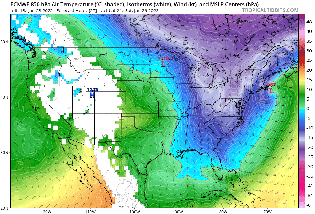
Unfortunately the 0z hasn’t loaded yet on tropical tidbits, but man that temp contrast is insane. Like -20c in eastern mass to above freezing just offshore. The thermals all around that area in eastern mass are warmer, there’s gotta be an absurd amount of dynamical cooling going on there.

-
I’m thinking Boston gets around 40 or so. I believe the snow ratios are being underestimated, and will be 20:1 or 25:1 in that death band that’s going to set up somewhere in eastern mass, sit there and rotate. The dynamics in that early Jan storm? Amazing, but in this storm the dynamics are expected to be even stronger. We have frigid Canadian air clashing with warmer than average oceans, I saw that the contrast was something crazy like temps in 20s clashing with ocean temps near 80 down south. That is helping beef up the low to what will eventually be tropical storm strength (I do believe the low will deepen more than expected by the models, to the 950s rather than 960s). The low is also closing off and stalling, so we could see like 4-6 inches of snow an hour for like 6 straight hours under the death band. QPF maps won’t pick up on that.
-
I thought he was talking about this storm https://weather.com/storms/winter/news/2018-03-19-winter-storm-toby-fourth-march-noreaster-northeast-snow
-
If Ray liked it yeah I probably got the wrong storm, he got like 30 from that mid March blizzard.
-
I don’t think he was talking the mid March one, he’s talking the late March one that nailed LI and whiffed eastern mass. The mid march one was awesome, I got 2 feet in that.
-
OH GOD NOT THAT STORM NOOOOOOOOOOO
-
Storm is overperforming in the coastal mid atlantic also looks to be overperforming in NYC. There’s no way that doesn’t translate to up here.
-
Yeah, if anything the precip shield is more expansive than modeled.
-
Boston? Only needs 27.2 to break the record, Boston can easily get 30+ due to snow ratios and models struggling with the dual low.
-
There are a lot of weenies here (such as myself) as well as pro meteorologists, and sometimes a combination of both. This board is awesome, I have lurked and posted in a few different ones and this one is definitely the best. Us big time snow weenies are made from massive blizzards like this, I remember I first discovered my passion for the weather during the blizzard in December 2010.
-
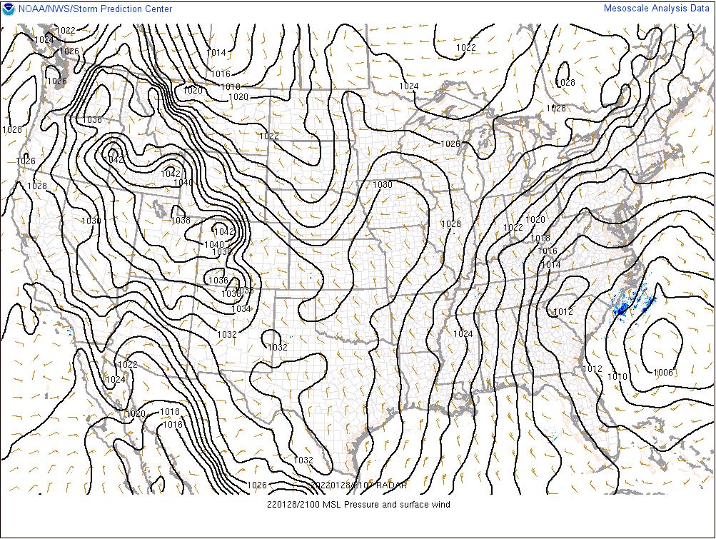
Guidance supports more than the QPF maps indicate. I’m no met either, but from what I have read the surface is also not supported by obs, the low is more west and is deepening more than expected. I mean look at this, the 12z euro which is “bad” qpf wise has 3 CLOSED CONTOURS off the cape. Bernie Rayno said on his livestream that a good rule of thumb is 1 foot of snow for each closed contour. It starts closing off south of Long Island and continues to deepen.
-
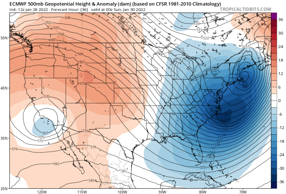
If he’s still in, I’m still in. Models are easy to ignore when the obs suggest they are wrong (at least the QPF outputs and snow maps, the 500 mb looks better).
-
Gfs, rgem and all the other shitty models that rob the convection tossed imo. They are all east of the Navy, and obs indicate the low is deepening faster than expected. TV Mets still have my area getting 18-24 and some have my area getting 24+.
-
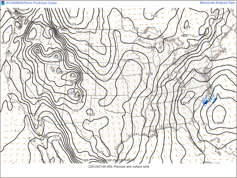
Interesting, the low is now down to 1006mb, 2mb deeper than the 18z nam had at this time (had the low down to 1008mb). The low is also less elongated.
-
Looks like a good middle ground between that crazy NAM run last night that gave NYC like 30 inches and the 12z Euro
-
And just as I make a big post about the 12z Navy, the Nam comes west again. I like the way things are going.
-
LETS ****ING GO!!!! NAVY ON BOARD!!!! No dual low on the navy and it deepens the low to 972 mb, this is a huge red flag and should not be ignored. The Navy gets a lot of shit, but it’s a useful model even if it’s verification scores aren’t the highest. The way I use the Navy is I don’t just look at it and assume it’s 100% right, because it usually isn’t (I have made this mistake before early on, but after a few horrible busts I learned my lesson). My rule of thumb with the Navy is that if it is farther west than other guidance, I throw all guidance east of the Navy out the window. I first heard of this rule a couple years ago back when I was still an anonymous lurker, and it seems to work well for the most part. When incorporating the Navy into my forecasts, I blend it with other guidance that is farther west, so for me I’m blending it with the 6z Euro (12z thrown out the window because it’s weaker and east of the Navy), 12z Nam, 12z Canadian, and a give a bit of weight to the short range RAP and SREFS. Since the Navy is so far west, I see that as a huge red flag and am giving more weight to the western guidance like the (high res) Nam, Srefs, and 6z Euro. Am I being a weenie? Maybe a little bit, but the Navy jumped west for the mid Jan inland runner like 3-4 days out, and once that happened I adjusted my forecast and gave up hope for anything more than a couple inches before a changeover to rain in my area.
-
It will likely verify but a lot of posters here are farther west. In eastern mass we are good for 2ft even on the more east models.
-
The models did a great job in the long and medium range sniffing out the threat, but have struggled with the details.
-
I don’t know if this means anything, but there is a 1010mb low off the coast of florida right now, and the 12z euro didn’t take the low down to 1010mb until 7pm (6 hours after it ran). Could this mean the low is deepening more than expected?
-
Knock it all you want but if the eastern low doesn’t form, it could end up being right.