

TimB
-
Posts
17,230 -
Joined
Content Type
Profiles
Blogs
Forums
American Weather
Media Demo
Store
Gallery
Everything posted by TimB
-
More than a few, if I had to guess. I’d check SPC archives if I had any idea of the date, but I think it happened in W PA once maybe last year or the year before. Edit: I forgot, ENH risk has only existed for a handful of years. So it probably hasn’t occurred many times.
-
Ah yes, the only place it’s sunny right now. We don’t have the other parameters lined up though. Further upstream over Ohio it looks like some isolated storms have fired.
-
Sun has come out upstream, if that changes the game any for instability.
-
40% chance of watch issuance...
-
Pillow has had enough rain this month, based on what I’ve seen from @mahantango#1. Hopefully you and @Bubbler86and @Mount Joy Snowmancan win today.
-
9:00 am, 12:30, 4:00, 9:00 pm (eastern) Latest outlook was largely the same as the morning one, though I’m sure the disco is worth looking at. Edit: as Newman mentioned below, the tornado outlook has decreased over PA.
-
But the Pillow Carnival is going on tonight. Some people have prepared all year for that (two years maybe, if it got cancelled last year) and I wouldn’t want them to get rained out.
-
I would tend to agree. It’s way too early to declare the severe threat DOA. But living up to the hype? That remains to be seen. That said, PBZ discussion says the MCS coming out of the Midwest has been modeled poorly thus far, and if the models don’t have that right, what else do they not have right? My point & click is down to a 20% chance of rain today and a 40% chance tonight, but of course I’m not in the prime area for this round like you guys are.
-
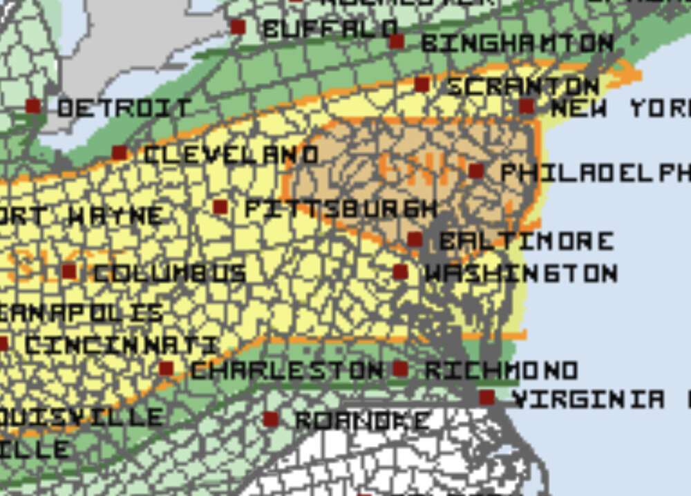
ENH moved north with 13z update:
-
Those destructive thugs, having the wind do their dirty work for them.
-
Looks like the SPC did upgrade to ENH risk roughly south of a State College to Pillow line.
-
18z GFS is back to that progressive ridge/trough pattern with no big or prolonged heat and some great days and nights in the cool parts of the pattern.
-
As a craft beer guy, I agree 100% that there’s a time and a place for light beer and usually that time and place is outside, when you plan on drinking all day. Can only drink so many 8%+ beers and it’s hard to pace.
-
I second that, craft for sure.
-
The famous canderson winds, summer edition.
-
I would assume that’s the case. But it’s not really a surprise when the GFS makes massive run to run changes beyond D7, so I have no desire to really look too far into it. If it were a pattern shift from a cold, snowy pattern in winter to a torch pattern, I might be more tempted to look at the details.
-
I know this is way late, but why in the world would there be any tears if, despite all the evidence for it, it turns out that scientists were wrong about one of the greatest threats to humanity?
-
GFS is back to spitting out a different look beyond 7 days with every run. It had a nice consistent look going for awhile.
-
Had this thought awhile back but I feel the two main issues would be 1) not much buy-in or 2) it wouldn’t work anyway because things devolve into off-topic banter without much warning and it’d be hard to contain. But wouldn’t be against giving it a shot. Would still have to be very careful with topics like covid because of how divisive they are. It would, however, potentially prevent people from having to read about the USA basketball team or the Pirates or Orioles or Steelers or Cowboys or masks or vaccines or the Pillow carnival if they don’t want to.
-
I don’t often look at CTP’s social media, or NWS social media pages in general, because of the aforementioned issue of the clueless masses chewing out mets.
-
@Itstrainingtime, exactly. Thanks for the correction.
-
I mean weather enthusiasts with even a moderate amount of understanding of the topic. I’m not talking about the jackasses who comment on NWS Facebook/Twitter posts. Pittsburghers bitch about weather, sports, anything more than most.
-
As with all politics-adjacent topics, the discourse is controlled by people who have spent their whole lives telling the people who cast votes for them what they want to hear.
-
Not saying it doesn’t happen, but in general I’m not a fan of criticizing people who are “experts” in their field when they are wrong about something we as a human race don’t fully understand or that inherently has a lot of uncertainty. I would argue that weather and covid are very similar in that regard.
-
The only thing I’ll say to this is, we don’t bash meteorologists when they’re wrong or reverse course on something.


