TimB
-
Posts
17,230 -
Joined
Content Type
Profiles
Blogs
Forums
American Weather
Media Demo
Store
Gallery
Everything posted by TimB
-
Correct, some models significantly weaken the MCS coming out of the Upper Midwest (which makes sense given timing), while others don’t weaken it as much.
-
CTP seems a little more bullish on the severe potential tomorrow than PBZ. They even have the severe wording in point/zone forecasts. PBZ says primarily showers with a few thunderstorms.
-
Speaking of things that snuck up on me. Wonder if tomorrow goes ENH for anyone.
-
July 19-20, 2019 immediately popped into my mind. Similar?
-
No, and it was a sneaky dry stretch. I was actually kind of surprised to realize this morning that we’ve gone 10 days with almost no rain. I checked 3 weather stations close to me, and none of them had more than .10” for that entire stretch.
-
To beat a serious gold medal contender like Iran by such a wide margin is big. I see no way the USA doesn’t take gold now! /s
-
I hadn’t really thought about it, but my grass is a little crunchy now. I think I got a pop-up storm at some point in the past 10 days, so mine would be a bit higher, but PIT’s past 10 day precip total stands at 0.01”.
-
Not being in D3 and D4 could be the thing that saves us easterners from any ridiculous heat. I mean I know you’re in a somewhat dry period, but it’s got nothing on the situation west of the Mississippi. Especially in Pittsburgh, which I’ve been told just doesn’t get droughts.
-
Still no indication that heat really wins on the GFS or any other model. This time it’s the 0z that has a little more of it, for those who believe in that stuff.
-
As far as the heat in other parts of the country that we may or may not see in these parts, the NWS currently has an uninterrupted area of heat advisories and warnings stretching from the Canadian border in Montana to the Gulf coast in Mississippi, including all or parts of 16 states.
-
Still gets swept away later in fantasy land.
-
And it’s the one from the midwest more so than the Atlantic one.
-
I went to Michigan two days after my second jab when they were spiking and even ate in a restaurant (twice!) and didn’t get covid. But that’s certainly not reason not to be cautious, and I fully realize I was lucky.
-
Well said. I think we all hope/wish this was over. Unfortunately it’s not. A lot of us will probably get covid at some point. For those of us who are vaccinated and/or young and healthy, we can hope it’ll be a mild illness (though not a guarantee). For those who are not vaccinated, a risk is being taken. I worry about what the future holds with all of this.
-

Western PA/Pittsburgh Summer Discussion 2021
TimB replied to Ahoff's topic in Upstate New York/Pennsylvania
My sympathies, @Ahoff. Just looked at the 5-min obs at KPIT and I don’t see anything above 86 as of 3pm. -
Yeah, there’s the whole timing of soundings/balloon launches thing. But if the initial data doesn’t change much, then why does the model result sometimes change wildly? That’s what I’m confused about.
-
Most of CTP, unfortunately.
-
I don’t buy them either, but devil’s advocate and all. And yes, I do think the two overnight GFS runs were almost identical.
-
God, I hope buffets are largely a casualty of covid. Places where you can not only increase your risk of getting covid, but increase your risk of death if you do get covid.
-
Also, if the CMC puts any ridge close to us the first weekend of August, it won’t be the Atlantic ridge but the Midwest one.
-
Don’t some people swear by the 0z/12z and consider the 6z/18z useless? I don’t really see it that way, but the runs that seem to bring the heat are almost always 6z/18z.
-
Same old, same old. Pattern we’ve had all summer.
-
If this sets up in winter:
-
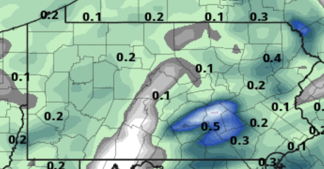
8/7 precip. Definitely not a good look for many, except a bullseye very close to a certain location:

-
That is a well defined frontal boundary. Maybe if it stalls out we can get some rain.