.jpg.7212c88cd7a6ee918250d4a9d2a8d183.jpg)

Chicago916
-
Posts
322 -
Joined
-
Last visited
Content Type
Profiles
Blogs
Forums
American Weather
Media Demo
Store
Gallery
Everything posted by Chicago916
-
Winter 2023/24 Medium/Long Range Discussion
Chicago916 replied to Chicago Storm's topic in Lakes/Ohio Valley
Not bad consistency for a week away.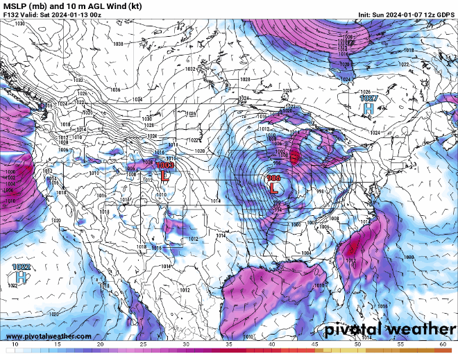
-
Winter 2023/24 Medium/Long Range Discussion
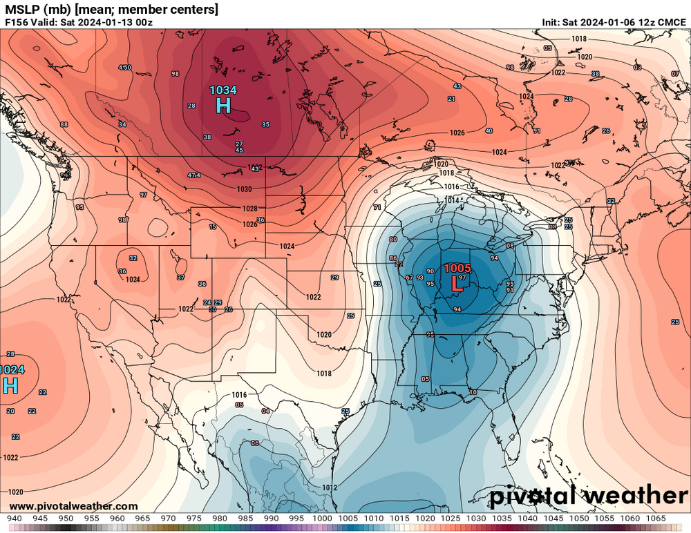
Chicago916 replied to Chicago Storm's topic in Lakes/Ohio Valley
Not a bad look on the EPS and CMCE. Shows the wide range in outcomes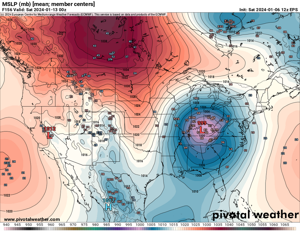
-
Winter 2023/24 Medium/Long Range Discussion
Chicago916 replied to Chicago Storm's topic in Lakes/Ohio Valley
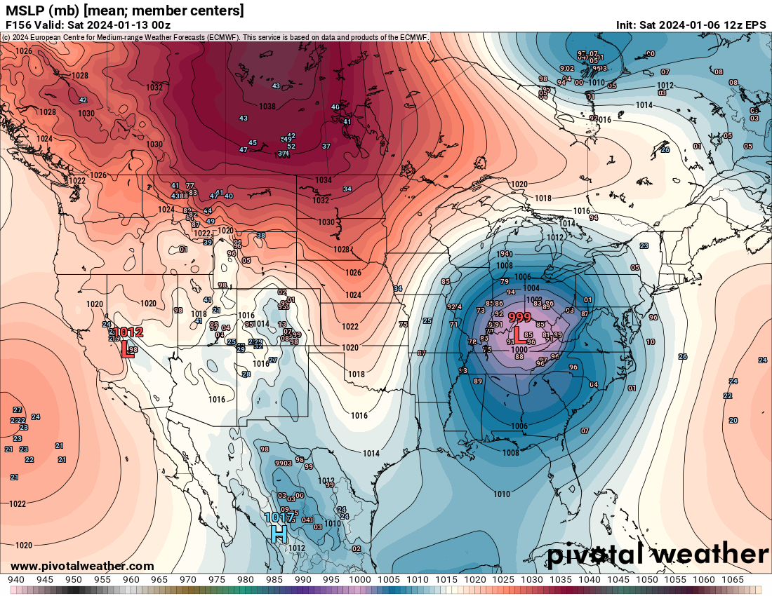
CMC has swapped with the GFS and has moved north with the big storm. As long as it doesn't go poof the next few days we should all be happy. -
Winter 2023/24 Medium/Long Range Discussion
Chicago916 replied to Chicago Storm's topic in Lakes/Ohio Valley
Someone wake RC up, he needs to replace his saved photos with the latest Euro lmao -
Winter 2023/24 Medium/Long Range Discussion
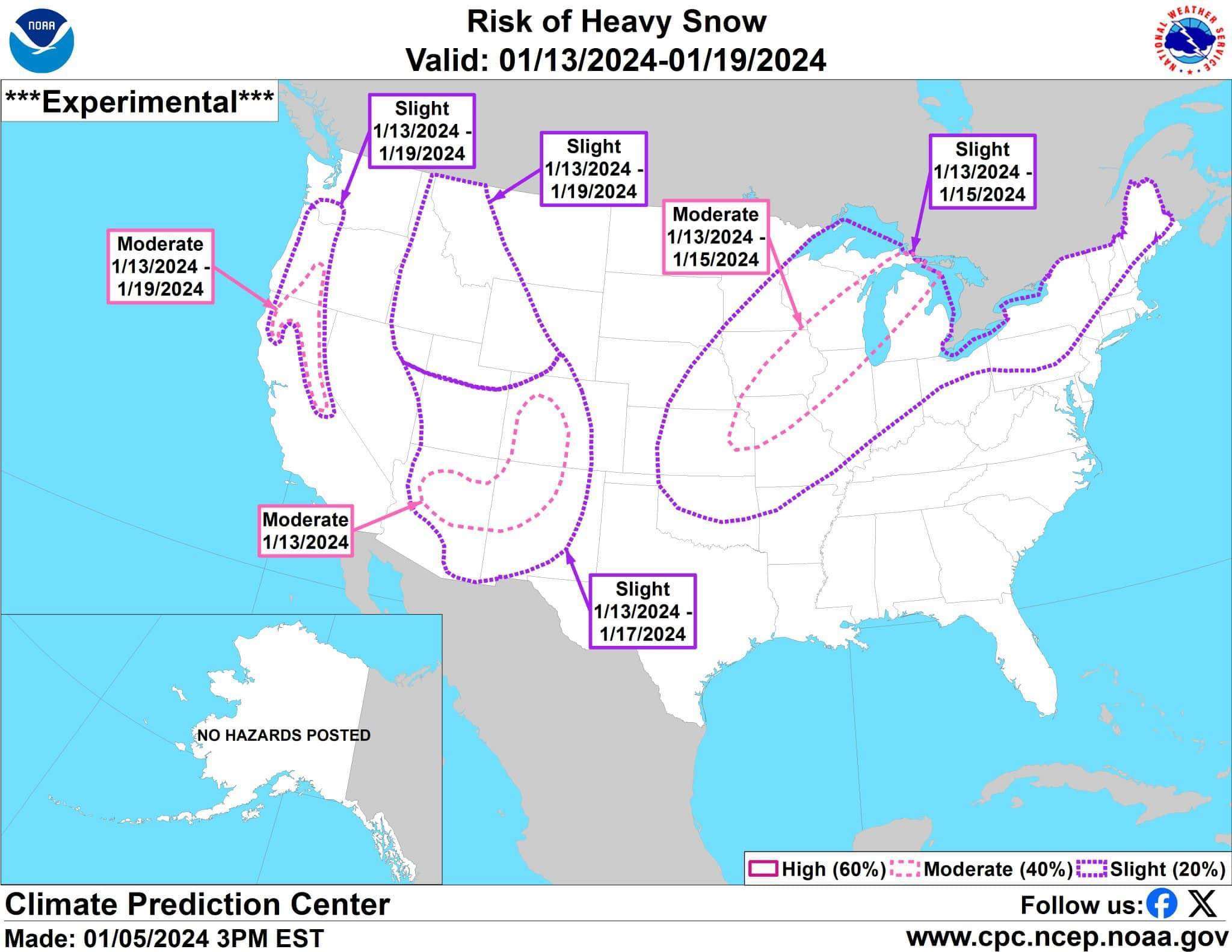
Chicago916 replied to Chicago Storm's topic in Lakes/Ohio Valley
Interesting that we have a moderate risk of heavy snow already prior to tonight's model runs.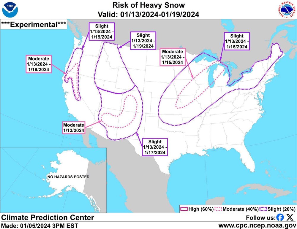
-
Winter 2023/24 Medium/Long Range Discussion
Chicago916 replied to Chicago Storm's topic in Lakes/Ohio Valley
Completely hypothetical... But if some location ever did receive 4 feet of snow in 36 hours, how high could a drift get? Real question for the pros though, how well can our weather models forecast an event on the leading edge of an arctic blast like what is shown? What do analogs show? The last one last year also was forecasting a decent snow at longer lead times (there were still blizzard warnings), but we mostly got an inch of dust with strong winds. -
Winter 2023/24 Medium/Long Range Discussion
Chicago916 replied to Chicago Storm's topic in Lakes/Ohio Valley
Since when did GFS 360hr fantasy blizzards show up at half lead time? Lmao -
Winter 2023/24 Medium/Long Range Discussion
Chicago916 replied to Chicago Storm's topic in Lakes/Ohio Valley
Tonight's GFS might make up for a boring last few winters. -
Imagine what the DGEX would've been doing with this storm... Glad that was retired years and years ago tho. Not this storm but radar looking good for a DAB tonight. Some decent banding.
-
Models trending this weekend's Northeast snow event a little snowier in the Midwest with the first piece of energy, now showing a small accumulation. Almost looks like the energy is more delayed in handing off to the coastal low. Would think the longer that's delayed the more snow that could be squeezed out in the Midwest? That should have some implications on thermals for the subsequent storm I would think.
-
The trends on the Northeast storm have me on edge wrt this storm, but both of the "storms" can't go poof like old times can they... I guess we'll see if past winter trends continue. Nice to see the CMC join the GFS on approximate track. Probably shouldn't pay close attention until a few days from now anyways.
-
Winter 2023/24 Medium/Long Range Discussion
Chicago916 replied to Chicago Storm's topic in Lakes/Ohio Valley
Big dog on the 18z GFS. Who's going to make the channel for it? Lol -
Winter 2023/24 Medium/Long Range Discussion
Chicago916 replied to Chicago Storm's topic in Lakes/Ohio Valley
12z EPS seems to still look fine based on mean QPF and low track. Not worth putting much stock into a single run at this point anyways. -
Winter 2023/24 Medium/Long Range Discussion
Chicago916 replied to Chicago Storm's topic in Lakes/Ohio Valley
I've still got a feeling the first storm this weekend trends more NW to brush NIL with some moderate snows. That'll then have an effect on larger storm afterwards I would think? -
Winter 2023/24 Medium/Long Range Discussion
Chicago916 replied to Chicago Storm's topic in Lakes/Ohio Valley
It would be funny if it verified, but is the CMC trying to resolve a Mesolow over Lake Michigan due to the ULL next Friday? Would be a funny way to transition from near 60F Christmas to 6"+ snow cover on NYE. -
Serious question. What will happen to a MCS (if and when it congeals and moves into NIL) as it barrels into the lake breeze?
-
Lake breeze now evident along with the outflow. Once these collide... Boom.
-
North moving boundary extremely evident on satellite
-
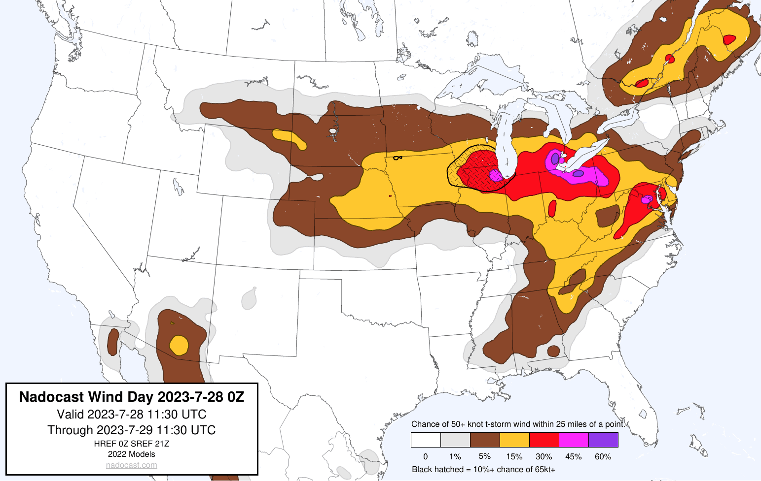
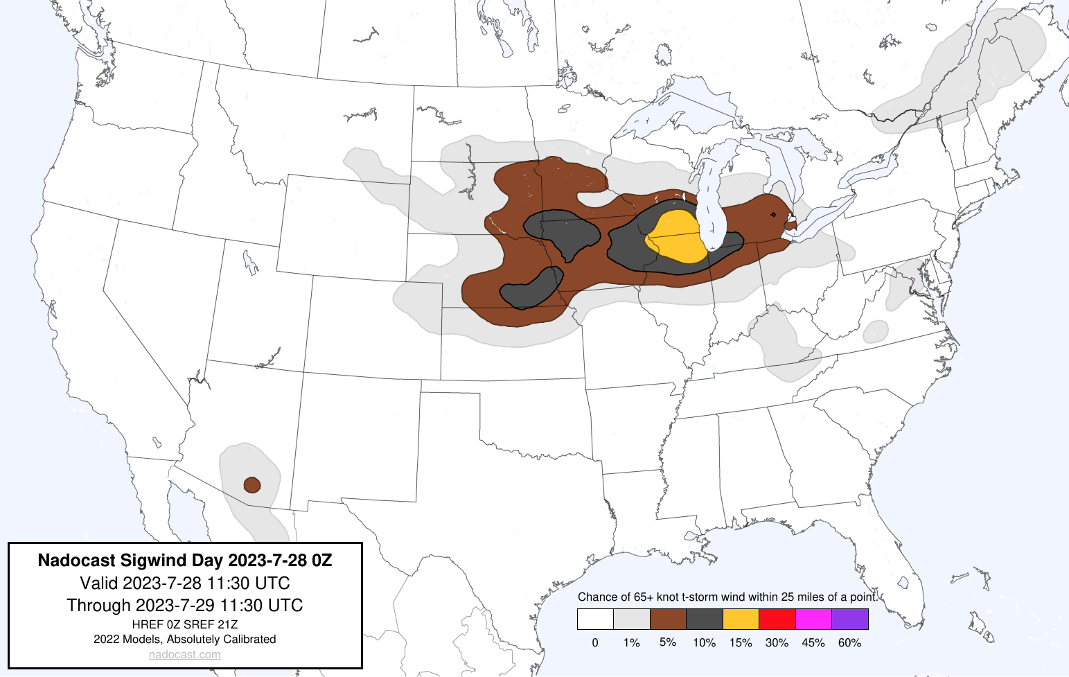
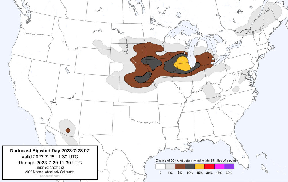
2023 Short/Medium Range Severe Weather Discussion
Chicago916 replied to Chicago Storm's topic in Lakes/Ohio Valley
Not sure how well Nadocast does for wind, but definitely has that Derecho look for tomorrow.
-
Inb4 Northern Illinois supercells this afternoon.
-
And round 2 to follow still in Southeast Minnesota?
-
Latest 12z HRDPS showing a look similar to the Chicago double Derecho on June 30, 2014 except further east https://www.spc.noaa.gov/exper/archive/event.php?date=20140630
-
Repeat of today this Friday? Looks interesting at least
-
2023 Short/Medium Range Severe Weather Discussion
Chicago916 replied to Chicago Storm's topic in Lakes/Ohio Valley
Sirens just started in the city -
2023 Short/Medium Range Severe Weather Discussion
Chicago916 replied to Chicago Storm's topic in Lakes/Ohio Valley
Well a lot happened since my post this morning. Sheesh. Finally seeing filtered sunshine downtown Chicago.