.jpg.7212c88cd7a6ee918250d4a9d2a8d183.jpg)

Chicago916
-
Posts
348 -
Joined
-
Last visited
Content Type
Profiles
Blogs
Forums
American Weather
Media Demo
Store
Gallery
Everything posted by Chicago916
-
It's the only way to get double digits in the city these days. The lake taketh, but rarely giveth.
-
Maybe at least a miss South will lead to some significant lake effect snow in NE IL as seen on in the Euro already and now seen on the Canadian model? Would be a nice consolation prize. Hate to have to rely on that though.
-
Were the latest European and Canadian ensembles showing an improvement the nudge needed to start this?
-
Fall/Winter '24 Banter and Complaints Go Here
Chicago916 replied to IWXwx's topic in Lakes/Ohio Valley
Seems like the last couple runs of the GEFS are starting to hint at some minor accumulations now. Decent accumulations in MI. -
Fall/Winter '24 Banter and Complaints Go Here
Chicago916 replied to IWXwx's topic in Lakes/Ohio Valley
It has no other model support but enjoying the hi-res models' unrealistic snow profiled runs for the NYE storm -
Winter 2024-25 Medium/Long Range Discussion
Chicago916 replied to michsnowfreak's topic in Lakes/Ohio Valley
Definitely some better trends lately for a snowy next couple of weeks? Seems like the mean trough position has shifted slightly west putting the GL and Midwest into a more favorable position. I'm not putting much faith in a large storm before the Arctic blast though, too much ptsd from the last time we saw that in modeling and got blizzard warnings for a glorified cold front. We'll see though, tons of moving parts. -
Winter 2024-25 Medium/Long Range Discussion
Chicago916 replied to michsnowfreak's topic in Lakes/Ohio Valley
Odds the pattern change brings Cutters west of our region, followed by Northeast storms and we're left in the dust? -
Winter 2024-25 Medium/Long Range Discussion
Chicago916 replied to michsnowfreak's topic in Lakes/Ohio Valley
Better odds of thunderstorms? -
Winter 2024-25 Medium/Long Range Discussion
Chicago916 replied to michsnowfreak's topic in Lakes/Ohio Valley
All jokes aside the trend is still good for the late week clipper. With some kind of lake enhancement, maybe someone in WI or IL will get 3"+... I guess some will take it before the huge torch and given how un-wintry things have been. Would be nice to even see fantasy big dogs again in models. -
Winter 2024-25 Medium/Long Range Discussion
Chicago916 replied to michsnowfreak's topic in Lakes/Ohio Valley
Funny to see the Wednesday trough keep trending West and slightly more negative. Too late for most of our Sub for a thread the needle on that system though. Maybe you guys in Ohio can somewhat cash in. -
Winter 2024-25 Medium/Long Range Discussion
Chicago916 replied to michsnowfreak's topic in Lakes/Ohio Valley
Low resolution caveats apply, but seems like some hints at LE on the Illinois side even with a miss South. -
Fall/Winter '24 Banter and Complaints Go Here
Chicago916 replied to IWXwx's topic in Lakes/Ohio Valley
Best I could do from my neck of the woods with light pollution during that substorm. Looks better if I fully saturate it lol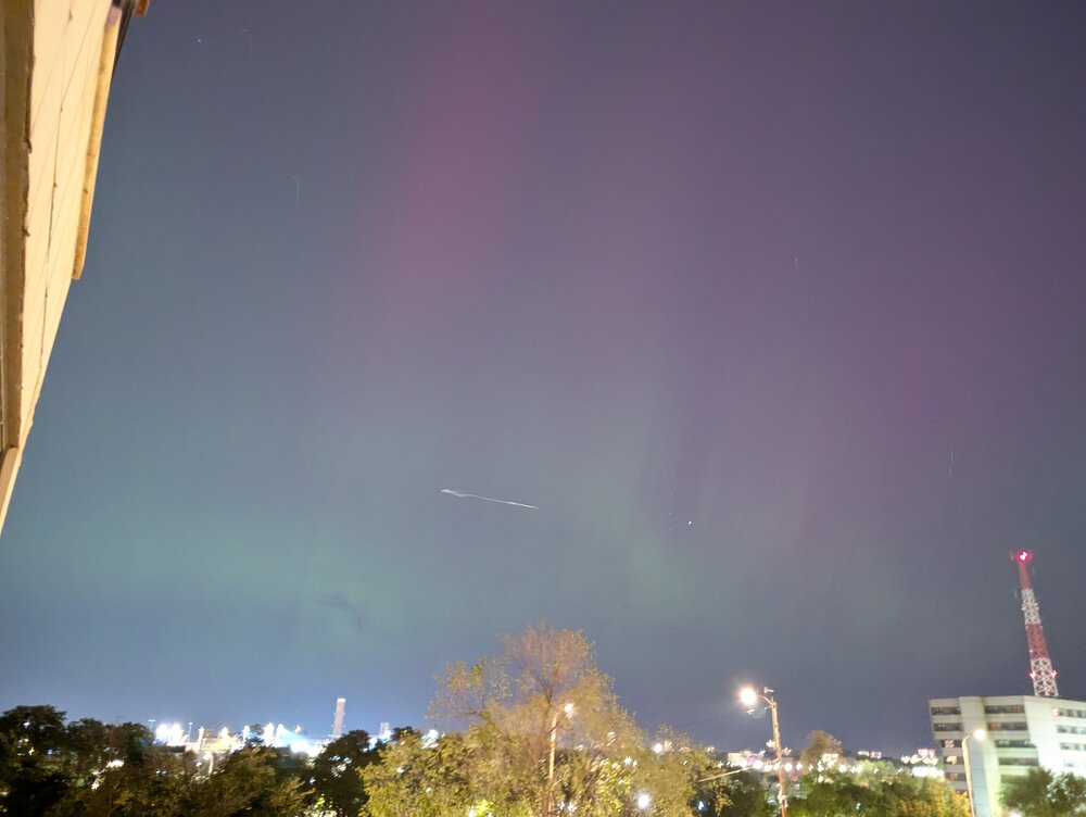
-
2024 Atlantic Hurricane Season
Chicago916 replied to Stormchaserchuck1's topic in Tropical Headquarters
I wonder if Helene's quick forward speed will limit cold upwelling waters in the Gulf in case another storm moves in on its heels. -
2024 Short/Medium Range Severe Weather Discussion
Chicago916 replied to Chicago Storm's topic in Lakes/Ohio Valley
This reminds me of a setup a few years back (I think) where the downtown area eventually went under a Tornado warning for an isolated right mover. Never dropped one though. This one! https://www.weather.gov/lot/2022jun13 -
2024 Short/Medium Range Severe Weather Discussion
Chicago916 replied to Chicago Storm's topic in Lakes/Ohio Valley
Quite the Supercell in McHenry County IL. Wonder if we'll get some Lake Breeze shenanigans. -
Possible tornados in WI not even under a 2% risk.
-
Tailend of that line near Rockford going to do funny business as it moves east?
-
A lot more CAMs than HRRR doing that now. I feel like anecdotally that always happens and the squall will actually survive past the Lake.
-
Looks like another shot for more photos tonight with much clearer skies. Going to actually charge my camera this time lol
-
Spring/Summer '24 Banter and Complaint Thread
Chicago916 replied to IWXwx's topic in Lakes/Ohio Valley
Possible low topped supers Tuesday could be fun. Knowing IL is the new tornado capital wouldn't be shocked to see a couple -
Spring/Summer '24 Banter and Complaint Thread
Chicago916 replied to IWXwx's topic in Lakes/Ohio Valley
Tis the season of Spring where warm fronts seemingly get stuck pushing north of the south tip of Lake Michigan. -
Spring/Summer '24 Banter and Complaint Thread
Chicago916 replied to IWXwx's topic in Lakes/Ohio Valley
Peeps in Southern WI going to enjoy the last bout of snow for the season on Friday? Glad that it'll pass North of here at least... -
Did Someone Say Clipper(Hybrid)!?! 1/18-1/19
Chicago916 replied to Frog Town's topic in Lakes/Ohio Valley
Hints on some of the CAMS of the lake effect band shifting west for a little bit towards Cook. -
Winter 2023/24 Medium/Long Range Discussion
Chicago916 replied to Chicago Storm's topic in Lakes/Ohio Valley
Benefits of an Arctic air mass being it won't take much QPF to result in accumulating snows, and the lake will now be beneficial vs. detrimental to those lakeside. -
Winter 2023/24 Short Range Discussion
Chicago916 replied to Chicago Storm's topic in Lakes/Ohio Valley
And now models trying to show lake effect action afterwards


