.jpg.7212c88cd7a6ee918250d4a9d2a8d183.jpg)

Chicago916
-
Posts
348 -
Joined
-
Last visited
Content Type
Profiles
Blogs
Forums
American Weather
Media Demo
Store
Gallery
Everything posted by Chicago916
-
11/8-11/10 First Snow and Lake Effect Event
Chicago916 replied to Geoboy645's topic in Lakes/Ohio Valley
Some really high DBZ coming ashore now. Likely graupel/hail and more thunder to come -
11/8-11/10 First Snow and Lake Effect Event
Chicago916 replied to Geoboy645's topic in Lakes/Ohio Valley
That more or less seems like what LOT just hinted at on Twitter too. Less likely there will be "slight break before a 2nd band". Seems to imply this will be the sole band now. Definitely would boost odds of some higher totals. -
11/8-11/10 First Snow and Lake Effect Event
Chicago916 replied to Geoboy645's topic in Lakes/Ohio Valley
Can't remember seeing "snow and a chance of thunderstorms" in a p&c before. Was laughing thinking about nadocast outlining the shore during the event in a forecast, but I'm sure waterspouts are filtered out from forecasts. -
11/8-11/10 First Snow and Lake Effect Event
Chicago916 replied to Geoboy645's topic in Lakes/Ohio Valley
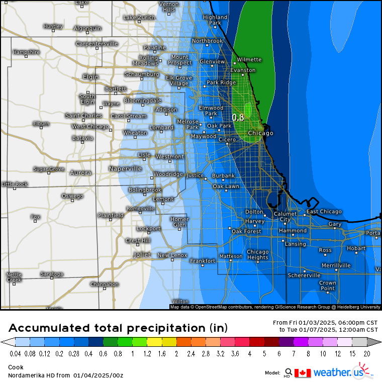
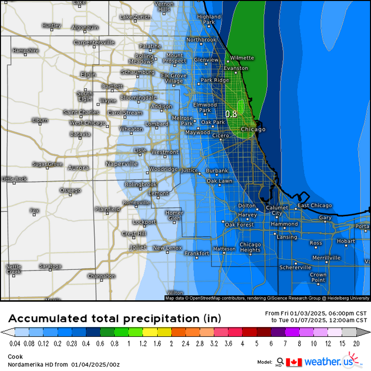
Updated "expected" snow maps upped a lot in Illinois to 7" expected in Chicago now. Probably cuz ^ and 18z hrrr. -
Definitely seems like today's 12z hi rez models are highlighting the swing of the LE into the IL side for a little. Liking trends, but won't expect it until we see the band on radar. Would be hilarious if the meso low pushes the snow too far west and leaves a gap.
-
Current forecast for Chicago is LOL worthy.
-
Not sure if mentioned before, but a great update to https://beta.pivotalweather.com/models/ Much better mobile UI.
-
Yeah I think the Ukie as well recently have been completely inaccurate. I'm cool with some snow, which at least looks likely with some mood flakes this weekend.
-
Canadian now with a casual 17" imby lol
-
It's been a rough stretch. At least 0z model watching is easier with DST once there's systems to track.
-
Don't agree with LOT?
-
Nahh. Just enjoying my daily couple hours of heat before free AC.
-
Backdoor cold front (and daily lake cooling) gonna suck.
-
Posting if allowed and if anyone didn't know it was ongoing. But a fun discussion on NOAA from some big names in weather.
-
Fall/Winter '24 Banter and Complaints Go Here
Chicago916 replied to IWXwx's topic in Lakes/Ohio Valley
Was scrolling through that earlier. Lots of cringe. Quite a few "oldtakesexposed" on Twitter as well. -
Winter 2024-25 Medium/Long Range Discussion
Chicago916 replied to michsnowfreak's topic in Lakes/Ohio Valley
Only mean SCP -
Patiently waiting for the 18z Euro to load up and for someone to happily or sadly post it...
-
Feels like the next model run is make or break. Lately that's where model downtrends have started and continued. Fingers crossed.
-
Winter 2024-25 Medium/Long Range Discussion
Chicago916 replied to michsnowfreak's topic in Lakes/Ohio Valley
Yeah I feel that. Just would love to be able to root for something at this point. It does look like we'll stay active through the end of the month with storms traversing our region. Hopefully some pan out! -
Winter 2024-25 Medium/Long Range Discussion
Chicago916 replied to michsnowfreak's topic in Lakes/Ohio Valley
At least this next potential storm we can all just root for better phasing and negative tilt to benefit us all and possibly screw the Northeast? -
Can clearly see developing radar echos on the Illinois side too from LOTs radar. Now we wait to see where the main plume develops and sits!
-
Fall/Winter '24 Banter and Complaints Go Here
Chicago916 replied to IWXwx's topic in Lakes/Ohio Valley
As an alumnus of UofI and living there many years and not getting much snow, I'm rooting for ya! -
Fall/Winter '24 Banter and Complaints Go Here
Chicago916 replied to IWXwx's topic in Lakes/Ohio Valley
Looks like next weekend we get disappointed again. Good trends lately for a more northerly storm as supposed to a Southern Slider, but too far out. -
Bullseye in my backyard, lock it in (0z RGEM)
-
I'm genuinely curious what post storm temperatures would look like in the Chicagoland Metro compared to outlying areas due to a hypothetical snowpack from this scenario.