

Spanks45
-
Posts
4,368 -
Joined
-
Last visited
Content Type
Profiles
Blogs
Forums
American Weather
Media Demo
Store
Gallery
Everything posted by Spanks45
-

November 2025 general discussions and probable topic derailings ...
Spanks45 replied to Typhoon Tip's topic in New England
22.8⁰, coldest of the season here. Added some some wood to the stove before bed and the house is a comfy 70⁰ this morning. -
November 2025 general discussions and probable topic derailings ...
Spanks45 replied to Typhoon Tip's topic in New England
12z GFS tried.....I feel like next week is good timing for the first 'flakes' of the season. No accumulations down here, but certainly some mangled flakes or even a few flurries with passing lake streamers. Even this morning had that vibe, couple dark clouds passing overhead, just a bit too warm, just a few sprinkles -
November 2025 general discussions and probable topic derailings ...
Spanks45 replied to Typhoon Tip's topic in New England
Just came in from outside and it is quite cold, already down to 33.1 -
November 2025 general discussions and probable topic derailings ...
Spanks45 replied to Typhoon Tip's topic in New England
baseball tryouts for travel next year was today, despite the winds and off and on clouds, it definitely felt warmer than expected for November 1st. Even last night with trick or treat, the air just didn't have that 'bite' to it. I hope it isn't another one of those seasons that it never gets cold enough for it to snow and stay snow....55° currently -
Spooky Season (October Disco Thread)
Spanks45 replied to Prismshine Productions's topic in New England
3.07" here, at least the ground water levels will be a bit happier going into winter....hopefully we can lay some snowfall down to help out in the Spring. Amazing how just getting an average year seems so out of reach -
Spooky Season (October Disco Thread)
Spanks45 replied to Prismshine Productions's topic in New England
24.6 this morning, what maples haven't lost their leaves are dropping them steadily this morning..... -
Woof, glad this isn't January...sitting here in WCT watching the band fizzle as it heads westward with only light rain/drizzle
-
Spooky Season (October Disco Thread)
Spanks45 replied to Prismshine Productions's topic in New England
Coldest point so far...26.8⁰ should pretty much take care of everything. Sadly the tomatoes were on a role, probably could have been picking through thanksgiving if the temps helped out. -
Spooky Season (October Disco Thread)
Spanks45 replied to Prismshine Productions's topic in New England
Thankfully the Jughandle bridge is there, before hand that area would close with any coastal storm/on shore flow. Timing is close, but seems like, if something develops it would be more late Friday into the weekend....they have had so much erosion lately, it probably won't take much to close rt 12. I was down in Hatteras a few years ago during an early season coastal, rt 12 was closed for 3 days. Kinda scary with 4 kids, if something were to have happened and we needed to head north. -
Spooky Season (October Disco Thread)
Spanks45 replied to Prismshine Productions's topic in New England
yikes....Northern or southern portion? The issues are Avon and south, Buxton/Rodanthe areas -
Spooky Season (October Disco Thread)
Spanks45 replied to Prismshine Productions's topic in New England
If correct, the OBX is going to take another one to the chin after losing 9 homes in the coastal storm/Erin situation....Hopefully what ever forms throws a ton of moisture up this way, after the weekend of course. -
Spooky Season (October Disco Thread)
Spanks45 replied to Prismshine Productions's topic in New England
same low temp here this morning as yesterday, 35.2....no frost though, we ended up with dense fog which seemed to have helped. The frost was enough to put an end to the massive amounts of pumpkins and gourds I have growing though, raspberries survived -
Spooky Season (October Disco Thread)
Spanks45 replied to Prismshine Productions's topic in New England
yeah, unique little sandy valley....you could feel it as soon as the sun went down that it was going to radiate perfectly....clear and calm again tonight should yield another round of mid 30s by sunrise, that and no return flow starting until after daybreak -
Spooky Season (October Disco Thread)
Spanks45 replied to Prismshine Productions's topic in New England
Frosty, 35.2⁰...kids are already asking when it is time to start the first fire...lol -
41.7⁰ this morning....if all goes right, first 30s here tomorrow morning? Euro looks pretty wet in the long range, need the rain but that looks like a miserable stretch if it were to happen that way.
-
right around 12 inches.....only 0.87 over the last 30 days
-
I have no clue how we are not even in the abnormally dry down here....even our perennial shrubs are fully wilted with browning leaves and dropping like it is October. Grass is brown and crispy and has been....It won't be long until wells start dropping at this rate
-
yeah, things are really dry despite some localized flooding last week. I think we are under half an inch this month here and the Pomperaug river is really low right now, lowest I have see it in quite some time. Trees locally have browning leaves, with the chilly morning it almost looked and felt like late September/early October
-
between weather and politics, all social media is a dumpster fire...making it worse, more believe the garbage than not beautiful day out, 73 with a breeze under full sun...need some rain soon
-
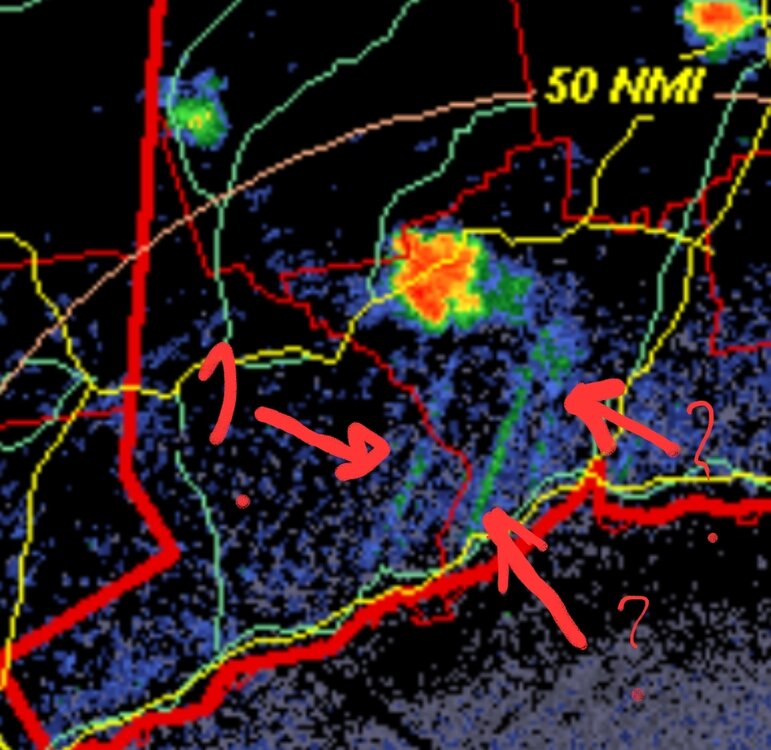
The radar has what looks like moisture being fed in strips to the storm nearby via the sound. Any other reason for the lines on the radar?
-
Havent had the AC on this entire month. Despite the warm days, all but 1 of the nights have dipped below 60, 2 of them below 50. Keep this going through October, but lets get some rain. Things are getting pretty crispy with the drier air.
-
July 2025 Obs/Disco ... possible historic month for heat
Spanks45 replied to Typhoon Tip's topic in New England
Glad this isnt winter and could have been snow.....would have been tough, lol -
July 2025 Obs/Disco ... possible historic month for heat
Spanks45 replied to Typhoon Tip's topic in New England
Yup, looks like we are going to be skunked around here. Im sure we will get some as the boundary drapes southward later on, but any convection is pretty much done for around here. Temps are dropping steadily over the past couple hours and the air has lost that muggy feel. -
July 2025 Obs/Disco ... possible historic month for heat
Spanks45 replied to Typhoon Tip's topic in New England
I recall last year's SW CT flood started on the models looking similar to that with the jackpot, hope it doesn't start shifting our way...we could use some rain, but not 4-8 inches of it -
July 2025 Obs/Disco ... possible historic month for heat
Spanks45 replied to Typhoon Tip's topic in New England
Sure did, add the whole house fan into the equation and sleeping wasn't too bad. Low got down to 67⁰ this morning, 72⁰ by midnight. House was 73⁰ when i woke up this morning. The house was almost 87⁰ at 9 pm last night... Nope.... Yeah, if they cant get it fixed today...the next 2 days are going to need one for sure. By Friday evening, windows will be wide open for sure


